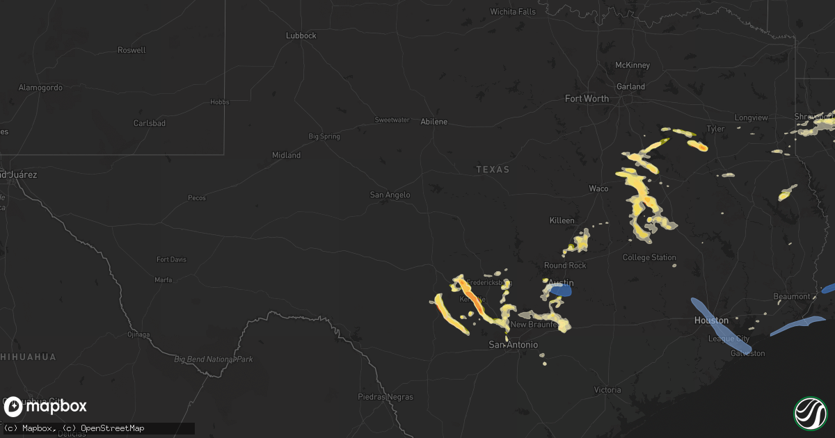
Hail Map in Texas on March 23, 2025
Get this storm
March 23 map
$229
one time, instant access
Download today. No call, no setup
Keep the $229
Bought the map and want the full workflow? Apply the entire $229 to a subscription within 7 days. None of it is wasted.
Every map, not just this one
This buys you this map. Subscription and you get every map we run, in the markets you choose from a few cities to whole states to nationwide. Plus real-time alerts the moment a storm fires.
Contact data
Name, contact info, occupancy, even credit band for addresses in the footprint. You go from where it hit to who to call.
Become the source they trust
Unlimited branding weather history reports on demand. You already have the documented answer ready for the property owner, and you are the one who showed up with it.
Property data and RoofTrace estimates
Pull up any address you have got, its value and the exact code rules for that jurisdiction, straight from One Click Code. Then RoofTrace estimates the squares, pitch, and roof value, priced the way you price.
Storm reports in Texas
Texas
| Date | Description |
|---|---|
| 03/23/20256:57 PM CDT | Near intersection of i-10 and fm 479. |
| 03/23/20256:54 PM CDT | Golf ball hail reported in kerens. |
| 03/23/20256:33 PM CDT | Photo of half dollar hail in mildred on social media. |
| 03/23/20256:25 PM CDT | Time estimated via radar. |
| 03/23/20258:54 AM CDT | Social media report of quarter-sized hail at the dam at lake palestine. |
| 03/23/20254:36 AM CDT | A local report indicates 66 MPH wind near 4 SE Sabine Pass |
| 03/23/20254:30 AM CDT | A local report indicates 70 MPH wind near 2 ENE Sea Rim State Par |
| 03/23/20254:27 AM CDT | Weathernet station at sabine pass school recorded a wind gust of 83 mph. |
| 03/23/20253:23 AM CDT | Galveston county emergency manager reported damage to a manufactured home at 427 9th street in san leon. Photos shared showed siding peeled off with a corner wall blown |
| 03/23/20253:22 AM CDT | Pearland regional airport asos recorded a 61 mph wind gust. |
| 03/23/20253:21 AM CDT | Khou asos recorded a 61 mph wind gust. |
| 03/23/20253:20 AM CDT | Mesonet station 9221d at morgans point measured a 58 mph wind gust. |
| 03/22/202511:03 PM CDT | Report from mping. |
| 03/22/202510:27 PM CDT | Report via social media. |
| 03/22/202510:25 PM CDT | A local report indicates 1.25 inch wind near 4 N Weir |
| 03/22/202510:24 PM CDT | Report from mping quarter |
| 03/22/202510:23 PM CDT | Report from mping. Time estimated by radar. |
| 03/22/202510:04 PM CDT | Ping pong ball size hail at cr 750 and cr 750a on lake limestone. |
| 03/22/202510:00 PM CDT | Quarter size hail covering the ground on southwest side of lake limestone. |
| 03/22/20259:59 PM CDT | A local report indicates 1.00 inch wind near Holland |
| 03/22/20259:57 PM CDT | Report from mping: quarter |
| 03/22/20259:53 PM CDT | Asos station kaus austin-bergstrom intl arpt. |
| 03/22/20259:50 PM CDT | 50 to 60 mph estimated winds. |
| 03/22/20259:35 PM CDT | A local report indicates 1.00 inch wind near 2 SW Boerne |
| 03/22/20259:24 PM CDT | Time estimated by radar. |
| 03/22/20259:22 PM CDT | Report from mping: quarter |
| 03/22/20259:11 PM CDT | Half dollar to ping pong ball size hail along lcr 456 south of mexia relayed via em. |
| 03/22/20259:06 PM CDT | Report from mping: half dollar |
| 03/22/20259:05 PM CDT | Golf ball size hail in berryville relayed via media. |
| 03/22/20259:05 PM CDT | Report from mping: quarter |
| 03/22/20259:00 PM CDT | A local report indicates 1.00 inch wind near 1 NNE Bee Cave |
| 03/22/20259:00 PM CDT | A picture was posted to social media of quarter size hail that fell near the teaselville community west of bullard. |
| 03/22/20258:57 PM CDT | Quarter size hail in frankston. |
| 03/22/20258:54 PM CDT | Corrects previous hail report from 2 nw cuney. Social media report of quarter-sized hail at the dam at lake palestine. |
| 03/22/20258:54 PM CDT | Time estimated by radar. |
| 03/22/20258:48 PM CDT | Quarter size hail at lcr 374 and honest ridge road relayed via em. |
| 03/22/20258:39 PM CDT | Report from mping: hen egg |
| 03/22/20258:23 PM CDT | A local report indicates 2.00 inch wind near 1 NE Center Point |
| 03/22/20258:19 PM CDT | Half dollar size hail near new york southwest of moore station relayed via media. Time estimated by radar. |
| 03/22/20258:06 PM CDT | Quarter size hail reported at fm 607 and cr 3612 southwest of brownsboro. |
| 03/22/20257:59 PM CDT | Quarter size hail reported at hwy 31 and fm 1803. |
| 03/22/20257:49 PM CDT | Report from mping: quarter |
| 03/22/20257:49 PM CDT | A local report indicates 1.00 inch wind near Kyle |
| 03/22/20257:37 PM CDT | A local report indicates 2.00 inch wind near Kerrville |
| 03/22/20257:37 PM CDT | Report from mping: tennis ball |
| 03/22/20257:33 PM CDT | A local report indicates 1.00 inch wind near San Augustine |
| 03/22/20257:30 PM CDT | Golf ball size hail via picture relayed by em near purdon |
| 03/22/20257:29 PM CDT | Kerrville near methodist encampment. |
| 03/22/20257:26 PM CDT | Golfball size hail at intersection of i-10 and harper rd. |
| 03/22/20257:11 PM CDT | Report from mping: quarter |
| 03/22/20257:09 PM CDT | Report from mping: quarter |
All States Impacted by Hail Map on March 23, 2025
Cities Impacted by Hail Map on March 23, 2025
- McCrory, AR
- Augusta, AR
- Tell City, IN
- Evanston, IN
- Cherry Valley, AR
- Hickory Ridge, AR
- Cannelton, IN
- Leopold, IN
- Troy, IN
- Wynne, AR
- Parkin, AR
- Dumas, MS
- Pioneer, LA
- Rayville, LA
- Oak Ridge, LA
- Baldwyn, MS
- Derby, IN
- New Albany, MS
- Guntown, MS
- Earle, AR
- Turrell, AR
- Tyronza, AR
- Booneville, MS
- Utica, MS
- Hollandale, MS
- Dermott, AR
- Marietta, MS
- Willow City, TX
- Fredericksburg, TX
- New Site, MS
- Crystal Springs, MS
- Edwards, MS
- Raymond, MS
- Gilmore, AR
- Tishomingo, MS
- Dennis, MS
- Belmont, MS
- Crawfordsville, AR
- Vance, MS
- Lambert, MS
- Millington, TN
- Centerville, TN
- Duck River, TN
- Lake Providence, LA
- Pontotoc, MS
- Randolph, MS
- Marion, AR
- Cherokee, AL
- Russellville, AL
- Red Bay, AL
- Paducah, KY
- Junction, TX
- Harper, TX
- Drew, MS
- Arkansas City, AR
- Rohwer, AR
- McGehee, AR
- Williamsport, TN
- Hampshire, TN
- Santa Fe, TN
- Brookport, IL
- Oak Grove, LA
- Anguilla, MS
- Mayersville, MS
- Rolling Fork, MS
- Glen Allan, MS
- Tutwiler, MS
- Charleston, MS
- Greenville, MS
- Hickory, KY
- Fancy Farm, KY
- Smithland, KY
- Ledbetter, KY
- Franklin, TN
- Enid, MS
- Batesville, MS
- Pope, MS
- Benoit, MS
- Corsicana, TX
- Florence, MS
- Terry, MS
- Columbia, TN
- Thompsons Station, TN
- Tuscumbia, AL
- Fredonia, KY
- Marion, KY
- Grand Rivers, KY
- Calvert City, KY
- Hamburg, AR
- Brentwood, TN
- Portland, AR
- Moorhead, MS
- Dubach, LA
- Homer, LA
- Bernice, LA
- Mayfield, KY
- Antioch, TN
- Nolensville, TN
- Symsonia, KY
- Tupelo, MS
- Oakland, MS
- Hampton, AR
- Mountain Home, TX
- Parkdale, AR
- Boaz, KY
- Belden, MS
- La Vergne, TN
- Canton, MS
- Smyrna, TN
- Arrington, TN
- Burna, KY
- Leland, MS
- Indianola, MS
- Inverness, MS
- Water Valley, MS
- Coffeeville, MS
- Strong, AR
- El Dorado, AR
- Montrose, AR
- Hermitage, TN
- Mount Juliet, TN
- Murfreesboro, TN
- Lebanon, TN
- Houlka, MS
- Pickens, MS
- Itta Bena, MS
- Fulton, KY
- Hickman, KY
- Plantersville, MS
- Vaughan, MS
- Camden, MS
- Bentonia, MS
- Courtland, MS
- Minter City, MS
- Philipp, MS
- Hermitage, AR
- Verona, MS
- Kerens, TX
- Leighton, AL
- Jersey, AR
- East Prairie, MO
- Clinton, KY
- Holcomb, MS
- Minden, LA
- Huttig, AR
- Lake Village, AR
- Harrisville, MS
- Gordonsville, TN
- Carthage, TN
- Brush Creek, TN
- Fulton, MS
- Scobey, MS
- Tillatoba, MS
- Florence, AL
- Sidon, MS
- Greenwood, MS
- Cascilla, MS
- Okolona, MS
- Shannon, MS
- Water Valley, KY
- Mooreville, MS
- Johnson City, TX
- Ruston, LA
- Boyle, MS
- Shaw, MS
- Elmwood, TN
- Nettleton, MS
- Frost, TX
- Stonewall, TX
- Farmington, KY
- Kirksey, KY
- Braxton, MS
- Ingram, TX
- Kerrville, TX
- Oxford, MS
- Sallis, MS
- Purdon, TX
- Groveton, TX
- Wingo, KY
- Sedalia, KY
- Golden, MS
- Fountain Hill, AR
- Goodman, MS
- Arkadelphia, AR
- Murray, KY
- Almo, KY
- San Augustine, TX
- Tremont, MS
- Paris, MS
- Granville, TN
- Watertown, TN
- Pleasant Shade, TN
- Gainesboro, TN
- Houston, MS
- Choudrant, LA
- Banner, MS
- Eustace, TX
- Mabank, TX
- Whitleyville, TN
- Hilham, TN
- Trinidad, TX
- Malakoff, TX
- Kosciusko, MS
- Carrollton, MS
- Pennington, TX
- Amory, MS
- Bruce, MS
- Hamilton, AL
- Coila, MS
- Crossett, AR
- Gibsland, LA
- Farmerville, LA
- Downsville, LA
- Barry, TX
- Brandon, MS
- Mendenhall, MS
- Hazel, KY
- Schlater, MS
- Hye, TX
- Blooming Grove, TX
- Smithville, MS
- Richland, TX
- Athens, TX
- Wortham, TX
- Lufkin, TX
- Spruce Pine, AL
- Aberdeen, MS
- Winona, MS
- Athens, LA
- Big Creek, MS
- Ethel, MS
- Lebanon Junction, KY
- McCarley, MS
- McCool, MS
- Cotton Valley, LA
- Kyle, TX
- Sunflower, MS
- Shreveport, LA
- Calhoun City, MS
- Shepherdsville, KY
- Mount Washington, KY
- Coxs Creek, KY
- Vardaman, MS
- Dawson, TX
- Arcadia, LA
- Doddsville, MS
- Mount Calm, TX
- Buda, TX
- Hubbard, TX
- Leakey, TX
- Taylorsville, KY
- Pittsboro, MS
- Hunt, TX
- Greenwood Springs, MS
- Coolidge, TX
- Comfort, TX
- Detroit, AL
- Clermont, KY
- Center Point, TX
- Iuka, MS
- Sulligent, AL
- Haughton, LA
- Bossier City, LA
- Kilmichael, MS
- Eudora, AR
- Larue, TX
- Murchison, TX
- Marion, LA
- Streetman, TX
- Princeton, LA
- Lisbon, LA
- Lockhart, TX
- Shelbyville, TX
- Beaverton, AL
- Morgantown, KY
- Roundhill, KY
- Brownsville, KY
- Blanco, TX
- Boerne, TX
- Mantachie, MS
- San Marcos, TX
- Brownsboro, TX
- Wilmot, AR
- Jones, LA
- North Carrollton, MS
- Mexia, TX
- Frankston, TX
- Summerfield, LA
- Haynesville, LA
- Simsboro, LA
- Bastrop, LA
- Caneyville, KY
- Bee Spring, KY
- Lawrenceburg, KY
- Fairfield, TX
- Prairie Hill, TX
- Groesbeck, TX
- Lillie, LA
- Mammoth Cave, KY
- Killen, AL
- Vanderpool, TX
- Versailles, KY
- Bloomfield, KY
- Dubberly, LA
- Kendalia, TX
- Elm Grove, LA
- Pipe Creek, TX
- Duck Hill, MS
- Guin, AL
- Stewart, MS
- Chatham, MS
- Town Creek, AL
- Moulton, AL
- Mount Hope, AL
- Winfield, AL
- Brilliant, AL
- Indian Mound, TN
- De Berry, TX
- Cub Run, KY
- Dripping Springs, TX
- Austin, TX
- Junction City, AR
- Spearsville, LA
- Medina, TX
- Palmyra, TN
- Maxwell, TX
- Sterlington, LA
- Prairie, MS
- Eupora, MS
- Sibley, LA
- Belzoni, MS
- Round Mountain, TX
- Teague, TX
- Isola, MS
- Bandera, TX
- Grenada, MS
- Wimberley, TX
- Driftwood, TX
- Bullard, TX
- Jacksonville, TX
- Nauvoo, AL
- Eldridge, AL
- Utopia, TX
- Tarpley, TX
- Doyline, LA
- Dellrose, TN
- Stonewall, LA
- Monroe, LA
- Spring Branch, TX
- Bergheim, TX
- Bear Creek, AL
- Canyon Lake, TX
- Silver City, MS
- Hamilton, MS
- Caledonia, MS
- Grambling, LA
- Buffalo, TX
- Bartlett, TX
- Salado, TX
- Kilgore, TX
- Belton, TX
- Thornton, TX
- Bulverde, TX
- Little River Academy, TX
- Temple, TX
- Kosse, TX
- Jewett, TX
- Carbon Hill, AL
- Fayetteville, TN
- Gattman, MS
- Manchaca, TX
- Jasper, AL
- Keithville, LA
- Maben, MS
- Holland, TX
- D Hanis, TX
- New Braunfels, TX
- Hillsboro, AL
- Trinity, AL
- Rogers, TX
- Vernon, AL
- Helotes, TX
- Del Valle, TX
- Hondo, TX
- San Antonio, TX
- Mathiston, MS
- Rosebud, TX
- Georgetown, TX
- Marquez, TX
- Yazoo City, MS
- Louise, MS
- Carthage, TX
- Gary, TX
- Franklin, TX
- Oakwood, TX
- Fayette, AL
- Bremond, TX
- Frierson, LA
- Tenaha, TX
- Granger, TX
- Jarrell, TX
- Mer Rouge, LA
- Henderson, TX
- Jamestown, LA
- Sturgis, MS
- Ringgold, LA
- Saltillo, MS
- Starkville, MS
- Townley, AL
- Seguin, TX
- Vaiden, MS
- Lexington, MS
- Kingsbury, TX
- Martindale, TX
- Luling, TX
- Joaquin, TX
- West, MS
- Keatchie, LA
- Heflin, LA
- Normangee, TX
- Durant, MS
- Calvert, TX
- Gonzales, TX
- Bremen, AL
- Hanceville, AL
- Vina, AL
- Hearne, TX
- Epps, LA
- Barksdale Afb, LA
- Benton, MS
- Jbsa Lackland, TX
- Madisonville, TX
- Stockdale, TX
- Sutherland Springs, TX
- Transylvania, LA
- Carthage, MS
- La Vernia, TX
- Mangham, LA
- Baskin, LA
- Coushatta, LA
- Rusk, TX
- Quitman, LA
- Floresville, TX
- Alto, TX
- Delhi, LA
- Jonesboro, LA
- Bryan, TX
- Louisville, MS
- Tallulah, LA
- Chatfield, TX
- Winnsboro, LA
- Chatham, LA
- Anderson, TX
- Newellton, LA
- Columbia, LA
- Huntsville, TX
- Pearl, MS
- Pelahatchie, MS
- Morton, MS
- Gore Springs, MS
- Forest, MS
- Lake, MS
- Pulaski, MS
- Vicksburg, MS
- Lorman, MS
- Lawrence, MS
- Newton, MS
- Haleyville, AL
- Port Gibson, MS
- Hickory, MS
- Houston, TX
- Baytown, TX
- Galena Park, TX
- Pasadena, TX
- South Houston, TX
- Pearland, TX
- Webster, TX
- Friendswood, TX
- League City, TX
- Dickinson, TX
- Santa Fe, TX
- Bacliff, TX
- Seabrook, TX
- Kemah, TX
- Texas City, TX
- La Marque, TX
- Galveston, TX
- Port Bolivar, TX
- Prattville, AL
- Anahuac, TX
- Cypress, TX
- Spring, TX
- Tomball, TX
- Jasper, TX
- Winnie, TX
- Jonesville, LA
- Evergreen, AL
- Beaumont, TX
- Port Arthur, TX
- Cameron, LA
- Sabine Pass, TX
- Orange, TX
- Bethany, LA
- Greenwood, LA
- Hackberry, LA
- Lake Charles, LA
- Vinton, LA
- Sulphur, LA
- Iowa, LA
- Bell City, LA
- Abbeville, LA
- Lacassine, LA
- Lake Arthur, LA
- Welsh, LA
- Erath, LA
- Jennings, LA
- Roanoke, LA
- Mermentau, LA
- Morse, LA
- Basile, LA
- Evangeline, LA
- Egan, LA
- Iota, LA
- Estherwood, LA
- Crowley, LA
- Eunice, LA
- Branch, LA
- Rayne, LA
- Kaplan, LA
- Lafayette, LA
- Scott, LA
- Duson, LA
- Church Point, LA
- Youngsville, LA
- Maurice, LA
- Broussard, LA
- Opelousas, LA
- Carencro, LA
- Sunset, LA
- Ville Platte, LA
- Oberlin, LA
- Saint Martinville, LA
- Breaux Bridge, LA
- Arnaudville, LA
- New Iberia, LA
- Port Barre, LA
- Washington, LA
- Krotz Springs, LA
- Palmetto, LA
- Lottie, LA
- Morganza, LA
- Maringouin, LA
- Fordoche, LA
- Grosse Tete, LA
- Melville, LA
- Plaquemine, LA
- Bienville, LA
- Hall Summit, LA
- Castor, LA


