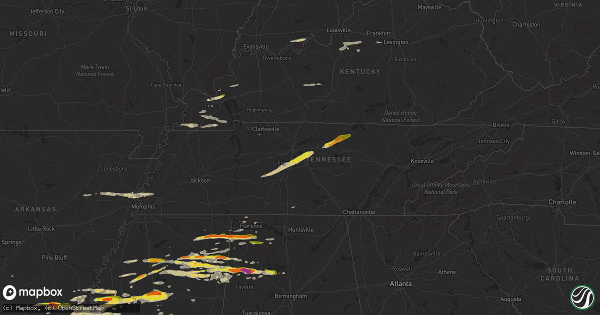
Hail Map on March 23, 2025
Get this storm
March 23 map
$229
one time, instant access
Download today. No call, no setup
Keep the $229
Bought the map and want the full workflow? Apply the entire $229 to a subscription within 7 days. None of it is wasted.
Every map, not just this one
This buys you this map. Subscription and you get every map we run, in the markets you choose from a few cities to whole states to nationwide. Plus real-time alerts the moment a storm fires.
Contact data
Name, contact info, occupancy, even credit band for addresses in the footprint. You go from where it hit to who to call.
Become the source they trust
Unlimited branding weather history reports on demand. You already have the documented answer ready for the property owner, and you are the one who showed up with it.
Property data and RoofTrace estimates
Pull up any address you have got, its value and the exact code rules for that jurisdiction, straight from One Click Code. Then RoofTrace estimates the squares, pitch, and roof value, priced the way you price.
States Impacted by Hail Map on March 23, 2025
Storm reports
Mississippi
| Date | Description |
|---|---|
| 03/23/20256:59 PM CDT | Report of quarter size hail south of fulton on hwy 25 about a half mile from the interstate. |
| 03/23/20256:57 PM CDT | Corrects previous hail report from 1 n fulton. Delayed report of half dollar size hail in fulton. Time estimated via radar. |
| 03/23/20256:53 PM CDT | Report of quarter size hail west of shannon and north of okolona. |
| 03/23/20256:45 PM CDT | Picture submitted via social media from near pickens. |
| 03/23/20256:44 PM CDT | Quarter size hail report from water valley. Time estimated via radar. |
| 03/23/20256:44 PM CDT | 3 power poles down. |
| 03/23/20256:25 PM CDT | Multiple reports of quarter size hail in sw tupelo near s thomas street and cliff gookin blvd. |
| 03/23/20256:23 PM CDT | Penny to quarter size. |
| 03/23/20255:52 PM CDT | Report of golf ball size hail in bloody springs. |
| 03/23/20255:32 PM CDT | A local report indicates 1.00 inch wind near Burton |
| 03/23/20255:15 PM CDT | Delayed report of multiple trees down along county road 5061 south of booneville. Time estimated via radar. |
| 03/23/20255:15 PM CDT | Report of quarter hail in frankstown. |
| 03/23/20255:10 PM CDT | Quarter size hail report near the booneville airport. |
| 03/22/20259:13 PM CDT | Outbuilding damaged. |
| 03/22/20259:08 PM CDT | Report of a tree down on thornton lane and a few tree limbs down on nash road. Time estimated via radar. |
| 03/22/20258:50 PM CDT | Golfball size hail fell near duck hill. |
| 03/22/20258:50 PM CDT | Public report of a tree down. |
| 03/22/20258:48 PM CDT | Homes in hollandale sustained shingle damage. |
| 03/22/20258:36 PM CDT | A local report indicates 1.00 inch wind near 2 SW Browning |
| 03/22/20258:36 PM CDT | A local report indicates 1.00 inch wind near 5 NNE Erwin |
| 03/22/20258:33 PM CDT | A local report indicates 1.00 inch wind near 2 N Rising Sun |
| 03/22/20258:19 PM CDT | Tree down on house reported by local emergency manager. |
| 03/22/20258:19 PM CDT | Tree do |
| 03/22/20258:17 PM CDT | Corrects previous tstm wnd dmg report from 4 n pyland. Public report of a tree down. |
| 03/22/20258:16 PM CDT | Report of quarter sized hail on hatley detroit road. |
| 03/22/20258:08 PM CDT | Report from mping of ping pong ball size hail. |
| 03/22/20257:48 PM CDT | A local report indicates 1.25 inch wind near 1 SSW Winona |
| 03/22/20257:45 PM CDT | Reported near leland. |
| 03/22/20257:30 PM CDT | Reported at glh airport. |
| 03/22/20257:30 PM CDT | Hail accumulated on the ground. Report via pictures submitted on social media. |
| 03/22/20257:27 PM CDT | A local report indicates 1.25 inch wind near 1 S Carrollton |
| 03/22/20257:25 PM CDT | House along ms hwy 16 damaged by a tornado. Trees and powerlines downed. |
| 03/22/20257:22 PM CDT | Photo of quarter-sized hail between bigbee and carolina. |
| 03/22/20257:20 PM CDT | Nickel to quarter size hail at attala co eoc. |
| 03/22/20257:16 PM CDT | A small vortex formed under a rotating wall cloud. Seen from ms highway 14 on the west side of rolling fork. |
| 03/22/20257:15 PM CDT | A local report indicates 2.00 inch wind near 2 WSW Kosciusko |
| 03/22/20257:11 PM CDT | Report of half dollar hail along hwy 45 near okolona. |
| 03/22/20257:09 PM CDT | Report of quarter size hail in coffeeville. |
| 03/22/20257:04 PM CDT | Social media report of quarter size hail near greenwood. |
| 03/22/20257:00 PM CDT | Report via social media from near florence. |
Arkansas
| Date | Description |
|---|---|
| 03/23/20256:58 PM CDT | A local report indicates 2.50 inch wind near Johnsville |
| 03/23/20256:51 PM CDT | A video was posted to social media of quarter size hail that fell near huttig. |
| 03/23/20256:49 PM CDT | Social media report of hail up to quarter size near fountain hill. |
| 03/23/20256:40 PM CDT | A local report indicates 1.00 inch wind near 2 W Ingalls |
| 03/23/20256:38 PM CDT | A local report indicates 1.00 inch wind near 2 S Dermott |
| 03/23/20255:13 PM CDT | A local report indicates 1.00 inch wind near 2 ESE Jericho |
| 03/23/20255:13 PM CDT | Powerlines down. |
| 03/22/20257:20 PM CDT | Emergency manager reported half dollar sized hail occurring at 7:20pm in south crossett.... |
| 03/22/20257:15 PM CDT | Quarter size hail falling in the crossett area. |
Tennessee
| Date | Description |
|---|---|
| 03/23/20256:35 PM CDT | Quarter size hail at the intersection of i-840 and stewarts ferry pike at 6:35 pm. Time estimated from radar. |
| 03/23/20256:25 PM CDT | Trained spotter reported half dollar size hail on murfreesboro rd near walmart in la vergne... Tn at 6:25 pm. |
| 03/23/20256:17 PM CDT | A local report indicates 1.00 inch wind near 2 E Franklin |
| 03/22/20257:13 PM CDT | Quarter size hail measured in gainesboro... Tn. Time estimated based on radar. |
| 03/22/20257:00 PM CDT | Quarter size hail in south carthage. Time estimated by radar. |
| 03/22/20257:00 PM CDT | Quarter size hail in south carthage. Time estimated by radar. |
Alabama
| Date | Description |
|---|---|
| 03/23/20256:30 PM CDT | Report received via 911 dispatch of a tree down on walnut lane. |
| 03/23/20256:28 PM CDT | Awing/cover to a back porch was blown off of a house littleville due to severe thunderstorm winds. |
| 03/23/20256:24 PM CDT | 911 dispatch reported a tree down at cr 33 and greenhill road. |
| 03/23/20255:59 PM CDT | Public report received of golf ball size hail which caused minor damage to vehicles. |
| 03/22/202510:40 PM CDT | Two trees blown down in garden city. Time estimated from radar. |
| 03/22/202510:22 PM CDT | A power pole was knocked down on cr-25. Time estimated by radar. |
| 03/22/20259:02 PM CDT | Golf ball size hail reported at the winfield travel plaza. |
| 03/22/20258:57 PM CDT | Photo and video of hail near guin ranging from quarter to half dollar size. |
| 03/22/20258:57 PM CDT | Report of quarter size hail near guin. |
| 03/22/20258:26 PM CDT | Quarter size hail observed in moulton. |
Texas
| Date | Description |
|---|---|
| 03/23/20256:57 PM CDT | Near intersection of i-10 and fm 479. |
| 03/23/20256:54 PM CDT | Golf ball hail reported in kerens. |
| 03/23/20256:33 PM CDT | Photo of half dollar hail in mildred on social media. |
| 03/23/20256:25 PM CDT | Time estimated via radar. |
| 03/23/20258:54 AM CDT | Social media report of quarter-sized hail at the dam at lake palestine. |
| 03/23/20254:36 AM CDT | A local report indicates 66 MPH wind near 4 SE Sabine Pass |
| 03/23/20254:30 AM CDT | A local report indicates 70 MPH wind near 2 ENE Sea Rim State Par |
| 03/23/20254:27 AM CDT | Weathernet station at sabine pass school recorded a wind gust of 83 mph. |
| 03/23/20253:23 AM CDT | Galveston county emergency manager reported damage to a manufactured home at 427 9th street in san leon. Photos shared showed siding peeled off with a corner wall blown |
| 03/23/20253:22 AM CDT | Pearland regional airport asos recorded a 61 mph wind gust. |
| 03/23/20253:21 AM CDT | Khou asos recorded a 61 mph wind gust. |
| 03/23/20253:20 AM CDT | Mesonet station 9221d at morgans point measured a 58 mph wind gust. |
| 03/22/202511:03 PM CDT | Report from mping. |
| 03/22/202510:27 PM CDT | Report via social media. |
| 03/22/202510:25 PM CDT | A local report indicates 1.25 inch wind near 4 N Weir |
| 03/22/202510:24 PM CDT | Report from mping quarter |
| 03/22/202510:23 PM CDT | Report from mping. Time estimated by radar. |
| 03/22/202510:04 PM CDT | Ping pong ball size hail at cr 750 and cr 750a on lake limestone. |
| 03/22/202510:00 PM CDT | Quarter size hail covering the ground on southwest side of lake limestone. |
| 03/22/20259:59 PM CDT | A local report indicates 1.00 inch wind near Holland |
| 03/22/20259:57 PM CDT | Report from mping: quarter |
| 03/22/20259:53 PM CDT | Asos station kaus austin-bergstrom intl arpt. |
| 03/22/20259:50 PM CDT | 50 to 60 mph estimated winds. |
| 03/22/20259:35 PM CDT | A local report indicates 1.00 inch wind near 2 SW Boerne |
| 03/22/20259:24 PM CDT | Time estimated by radar. |
| 03/22/20259:22 PM CDT | Report from mping: quarter |
| 03/22/20259:11 PM CDT | Half dollar to ping pong ball size hail along lcr 456 south of mexia relayed via em. |
| 03/22/20259:06 PM CDT | Report from mping: half dollar |
| 03/22/20259:05 PM CDT | Golf ball size hail in berryville relayed via media. |
| 03/22/20259:05 PM CDT | Report from mping: quarter |
| 03/22/20259:00 PM CDT | A local report indicates 1.00 inch wind near 1 NNE Bee Cave |
| 03/22/20259:00 PM CDT | A picture was posted to social media of quarter size hail that fell near the teaselville community west of bullard. |
| 03/22/20258:57 PM CDT | Quarter size hail in frankston. |
| 03/22/20258:54 PM CDT | Time estimated by radar. |
| 03/22/20258:54 PM CDT | Corrects previous hail report from 2 nw cuney. Social media report of quarter-sized hail at the dam at lake palestine. |
| 03/22/20258:48 PM CDT | Quarter size hail at lcr 374 and honest ridge road relayed via em. |
| 03/22/20258:39 PM CDT | Report from mping: hen egg |
| 03/22/20258:23 PM CDT | A local report indicates 2.00 inch wind near 1 NE Center Point |
| 03/22/20258:19 PM CDT | Half dollar size hail near new york southwest of moore station relayed via media. Time estimated by radar. |
| 03/22/20258:06 PM CDT | Quarter size hail reported at fm 607 and cr 3612 southwest of brownsboro. |
| 03/22/20257:59 PM CDT | Quarter size hail reported at hwy 31 and fm 1803. |
| 03/22/20257:49 PM CDT | A local report indicates 1.00 inch wind near Kyle |
| 03/22/20257:49 PM CDT | Report from mping: quarter |
| 03/22/20257:37 PM CDT | A local report indicates 2.00 inch wind near Kerrville |
| 03/22/20257:37 PM CDT | Report from mping: tennis ball |
| 03/22/20257:33 PM CDT | A local report indicates 1.00 inch wind near San Augustine |
| 03/22/20257:30 PM CDT | Golf ball size hail via picture relayed by em near purdon |
| 03/22/20257:29 PM CDT | Kerrville near methodist encampment. |
| 03/22/20257:26 PM CDT | Golfball size hail at intersection of i-10 and harper rd. |
| 03/22/20257:11 PM CDT | Report from mping: quarter |
| 03/22/20257:09 PM CDT | Report from mping: quarter |
Kentucky
| Date | Description |
|---|---|
| 03/23/20256:08 PM CDT | A local report indicates 1.00 inch wind near 6 ESE Smithland |
Louisiana
| Date | Description |
|---|---|
| 03/23/20256:44 PM CDT | Pictures of golfball size hail were posted to social media just southeast of bernice. |
| 03/23/20255:21 PM CDT | 1.5 to 2.0 inch hail along hwy 17. |
| 03/23/20255:20 PM CDT | A local report indicates 1.25 inch wind near Pioneer |
| 03/23/20256:30 AM CDT | Photos received of a roof partially lifted off a trailer home near academy drive in richard... La. |
| 03/23/20256:20 AM CDT | Several photos received of many trees down in the community of ritchie... La southwest of eunice. Several homes impacted... One with a tree through the middle of the st |
| 03/23/20255:15 AM CDT | Photos received of a large tree downed partially through the roof of a house in the maplewood subdivision in sulphur... La. |
| 03/23/20254:44 AM CDT | Recorded on a personal weather station. |
| 03/23/202512:53 AM CDT | Golfball size hail fell in the conway community north of farmerville. |
| 03/23/202512:43 AM CDT | A picture was posted to social media of quarter size hail that fell on raymond odom road north of farmerville. |
| 03/23/202512:19 AM CDT | A large tree was blown down on highway 2 on the eastern side of the bernice city limits. |
| 03/23/202512:14 AM CDT | A picture of quarter to half dollar size hail was posted to social media that fell just west of bernice. |
| 03/22/202510:45 PM CDT | Public report of quarter-sized hail on missile base rd. |
| 03/22/202510:43 PM CDT | Social media report of quarter-sized hail in bienville. |
| 03/22/20259:05 PM CDT | A local report indicates 1.00 inch wind near 4 E Arcadia |
| 03/22/20258:30 PM CDT | Social media post of quarter sized hail on lauri ln |
| 03/22/20258:10 PM CDT | Public report of quarter-sized hail on lake claiborne. |
| 03/22/20258:08 PM CDT | Rocky branch on hwy 143 north of the nwr. |
| 03/22/20258:08 PM CDT | Public report of golf ball sized hail on 552 in point... La. |
| 03/22/20257:52 PM CDT | A local report indicates 1.00 inch wind near 1 N Homer |
| 03/22/20257:42 PM CDT | Quarter size hail in the point community. |
| 03/22/20257:22 PM CDT | A picture was posted to social media of quarter size hail that fell along highway 15 between chelsea lane and mosleys bluff road. |
| 03/22/20257:12 PM CDT | Corrects previous hail report from 1 se farmerville. Rocky branch on hwy 143 north of the nwr. |
| 03/22/20257:12 PM CDT | Quarter to half dollar size hail fell in minden. |
Cities Impacted by Hail Map on March 23, 2025
- McCrory, AR
- Augusta, AR
- Tell City, IN
- Evanston, IN
- Cherry Valley, AR
- Hickory Ridge, AR
- Cannelton, IN
- Leopold, IN
- Troy, IN
- Wynne, AR
- Parkin, AR
- Dumas, MS
- Pioneer, LA
- Rayville, LA
- Oak Ridge, LA
- Baldwyn, MS
- Derby, IN
- New Albany, MS
- Guntown, MS
- Earle, AR
- Turrell, AR
- Tyronza, AR
- Booneville, MS
- Utica, MS
- Hollandale, MS
- Dermott, AR
- Marietta, MS
- Willow City, TX
- Fredericksburg, TX
- New Site, MS
- Crystal Springs, MS
- Edwards, MS
- Raymond, MS
- Gilmore, AR
- Tishomingo, MS
- Dennis, MS
- Belmont, MS
- Crawfordsville, AR
- Vance, MS
- Lambert, MS
- Millington, TN
- Centerville, TN
- Duck River, TN
- Lake Providence, LA
- Pontotoc, MS
- Randolph, MS
- Marion, AR
- Cherokee, AL
- Russellville, AL
- Red Bay, AL
- Paducah, KY
- Junction, TX
- Harper, TX
- Drew, MS
- Arkansas City, AR
- Rohwer, AR
- McGehee, AR
- Williamsport, TN
- Hampshire, TN
- Santa Fe, TN
- Brookport, IL
- Oak Grove, LA
- Anguilla, MS
- Mayersville, MS
- Rolling Fork, MS
- Glen Allan, MS
- Tutwiler, MS
- Charleston, MS
- Greenville, MS
- Hickory, KY
- Fancy Farm, KY
- Smithland, KY
- Ledbetter, KY
- Franklin, TN
- Enid, MS
- Batesville, MS
- Pope, MS
- Benoit, MS
- Corsicana, TX
- Florence, MS
- Terry, MS
- Columbia, TN
- Thompsons Station, TN
- Tuscumbia, AL
- Fredonia, KY
- Marion, KY
- Grand Rivers, KY
- Calvert City, KY
- Hamburg, AR
- Brentwood, TN
- Portland, AR
- Moorhead, MS
- Dubach, LA
- Homer, LA
- Bernice, LA
- Mayfield, KY
- Antioch, TN
- Nolensville, TN
- Symsonia, KY
- Tupelo, MS
- Oakland, MS
- Hampton, AR
- Mountain Home, TX
- Parkdale, AR
- Boaz, KY
- Belden, MS
- La Vergne, TN
- Canton, MS
- Smyrna, TN
- Arrington, TN
- Burna, KY
- Leland, MS
- Indianola, MS
- Inverness, MS
- Water Valley, MS
- Coffeeville, MS
- Strong, AR
- El Dorado, AR
- Montrose, AR
- Hermitage, TN
- Mount Juliet, TN
- Murfreesboro, TN
- Lebanon, TN
- Houlka, MS
- Pickens, MS
- Itta Bena, MS
- Fulton, KY
- Hickman, KY
- Plantersville, MS
- Vaughan, MS
- Camden, MS
- Bentonia, MS
- Courtland, MS
- Minter City, MS
- Philipp, MS
- Hermitage, AR
- Verona, MS
- Kerens, TX
- Leighton, AL
- Jersey, AR
- East Prairie, MO
- Clinton, KY
- Holcomb, MS
- Minden, LA
- Huttig, AR
- Lake Village, AR
- Harrisville, MS
- Gordonsville, TN
- Carthage, TN
- Brush Creek, TN
- Fulton, MS
- Scobey, MS
- Tillatoba, MS
- Florence, AL
- Sidon, MS
- Greenwood, MS
- Cascilla, MS
- Okolona, MS
- Shannon, MS
- Water Valley, KY
- Mooreville, MS
- Johnson City, TX
- Ruston, LA
- Boyle, MS
- Shaw, MS
- Elmwood, TN
- Nettleton, MS
- Frost, TX
- Stonewall, TX
- Farmington, KY
- Kirksey, KY
- Braxton, MS
- Ingram, TX
- Kerrville, TX
- Oxford, MS
- Sallis, MS
- Purdon, TX
- Groveton, TX
- Wingo, KY
- Sedalia, KY
- Golden, MS
- Fountain Hill, AR
- Goodman, MS
- Arkadelphia, AR
- Murray, KY
- Almo, KY
- San Augustine, TX
- Tremont, MS
- Paris, MS
- Granville, TN
- Watertown, TN
- Pleasant Shade, TN
- Gainesboro, TN
- Houston, MS
- Choudrant, LA
- Banner, MS
- Eustace, TX
- Mabank, TX
- Whitleyville, TN
- Hilham, TN
- Trinidad, TX
- Malakoff, TX
- Kosciusko, MS
- Carrollton, MS
- Pennington, TX
- Amory, MS
- Bruce, MS
- Hamilton, AL
- Coila, MS
- Crossett, AR
- Gibsland, LA
- Farmerville, LA
- Downsville, LA
- Barry, TX
- Brandon, MS
- Mendenhall, MS
- Hazel, KY
- Schlater, MS
- Hye, TX
- Blooming Grove, TX
- Smithville, MS
- Richland, TX
- Athens, TX
- Wortham, TX
- Lufkin, TX
- Spruce Pine, AL
- Aberdeen, MS
- Winona, MS
- Athens, LA
- Big Creek, MS
- Ethel, MS
- Lebanon Junction, KY
- McCarley, MS
- McCool, MS
- Cotton Valley, LA
- Kyle, TX
- Sunflower, MS
- Shreveport, LA
- Calhoun City, MS
- Shepherdsville, KY
- Mount Washington, KY
- Coxs Creek, KY
- Vardaman, MS
- Dawson, TX
- Arcadia, LA
- Doddsville, MS
- Mount Calm, TX
- Buda, TX
- Hubbard, TX
- Leakey, TX
- Taylorsville, KY
- Pittsboro, MS
- Hunt, TX
- Greenwood Springs, MS
- Coolidge, TX
- Comfort, TX
- Detroit, AL
- Clermont, KY
- Center Point, TX
- Iuka, MS
- Sulligent, AL
- Haughton, LA
- Bossier City, LA
- Kilmichael, MS
- Eudora, AR
- Larue, TX
- Murchison, TX
- Marion, LA
- Streetman, TX
- Princeton, LA
- Lisbon, LA
- Lockhart, TX
- Shelbyville, TX
- Beaverton, AL
- Morgantown, KY
- Roundhill, KY
- Brownsville, KY
- Blanco, TX
- Boerne, TX
- Mantachie, MS
- San Marcos, TX
- Brownsboro, TX
- Wilmot, AR
- Jones, LA
- North Carrollton, MS
- Mexia, TX
- Frankston, TX
- Summerfield, LA
- Haynesville, LA
- Simsboro, LA
- Bastrop, LA
- Caneyville, KY
- Bee Spring, KY
- Lawrenceburg, KY
- Fairfield, TX
- Prairie Hill, TX
- Groesbeck, TX
- Lillie, LA
- Mammoth Cave, KY
- Killen, AL
- Vanderpool, TX
- Versailles, KY
- Bloomfield, KY
- Dubberly, LA
- Kendalia, TX
- Elm Grove, LA
- Pipe Creek, TX
- Duck Hill, MS
- Guin, AL
- Stewart, MS
- Chatham, MS
- Town Creek, AL
- Moulton, AL
- Mount Hope, AL
- Winfield, AL
- Brilliant, AL
- Indian Mound, TN
- De Berry, TX
- Cub Run, KY
- Dripping Springs, TX
- Austin, TX
- Junction City, AR
- Spearsville, LA
- Medina, TX
- Palmyra, TN
- Maxwell, TX
- Sterlington, LA
- Prairie, MS
- Eupora, MS
- Sibley, LA
- Belzoni, MS
- Round Mountain, TX
- Teague, TX
- Isola, MS
- Bandera, TX
- Grenada, MS
- Wimberley, TX
- Driftwood, TX
- Bullard, TX
- Jacksonville, TX
- Nauvoo, AL
- Eldridge, AL
- Utopia, TX
- Tarpley, TX
- Doyline, LA
- Dellrose, TN
- Stonewall, LA
- Monroe, LA
- Spring Branch, TX
- Bergheim, TX
- Bear Creek, AL
- Canyon Lake, TX
- Silver City, MS
- Hamilton, MS
- Caledonia, MS
- Grambling, LA
- Buffalo, TX
- Bartlett, TX
- Salado, TX
- Kilgore, TX
- Belton, TX
- Thornton, TX
- Bulverde, TX
- Little River Academy, TX
- Temple, TX
- Kosse, TX
- Jewett, TX
- Carbon Hill, AL
- Fayetteville, TN
- Gattman, MS
- Manchaca, TX
- Jasper, AL
- Keithville, LA
- Maben, MS
- Holland, TX
- D Hanis, TX
- New Braunfels, TX
- Hillsboro, AL
- Trinity, AL
- Rogers, TX
- Vernon, AL
- Helotes, TX
- Del Valle, TX
- Hondo, TX
- San Antonio, TX
- Mathiston, MS
- Rosebud, TX
- Georgetown, TX
- Marquez, TX
- Yazoo City, MS
- Louise, MS
- Carthage, TX
- Gary, TX
- Franklin, TX
- Oakwood, TX
- Fayette, AL
- Bremond, TX
- Frierson, LA
- Tenaha, TX
- Granger, TX
- Jarrell, TX
- Mer Rouge, LA
- Henderson, TX
- Jamestown, LA
- Sturgis, MS
- Ringgold, LA
- Saltillo, MS
- Starkville, MS
- Townley, AL
- Seguin, TX
- Vaiden, MS
- Lexington, MS
- Kingsbury, TX
- Martindale, TX
- Luling, TX
- Joaquin, TX
- West, MS
- Keatchie, LA
- Heflin, LA
- Normangee, TX
- Durant, MS
- Calvert, TX
- Gonzales, TX
- Bremen, AL
- Hanceville, AL
- Vina, AL
- Hearne, TX
- Epps, LA
- Barksdale Afb, LA
- Benton, MS
- Jbsa Lackland, TX
- Madisonville, TX
- Stockdale, TX
- Sutherland Springs, TX
- Transylvania, LA
- Carthage, MS
- La Vernia, TX
- Mangham, LA
- Baskin, LA
- Coushatta, LA
- Rusk, TX
- Quitman, LA
- Floresville, TX
- Alto, TX
- Delhi, LA
- Jonesboro, LA
- Bryan, TX
- Louisville, MS
- Tallulah, LA
- Chatfield, TX
- Winnsboro, LA
- Chatham, LA
- Anderson, TX
- Newellton, LA
- Columbia, LA
- Huntsville, TX
- Pearl, MS
- Pelahatchie, MS
- Morton, MS
- Gore Springs, MS
- Forest, MS
- Lake, MS
- Pulaski, MS
- Vicksburg, MS
- Lorman, MS
- Lawrence, MS
- Newton, MS
- Haleyville, AL
- Port Gibson, MS
- Hickory, MS
- Houston, TX
- Baytown, TX
- Galena Park, TX
- Pasadena, TX
- South Houston, TX
- Pearland, TX
- Webster, TX
- Friendswood, TX
- League City, TX
- Dickinson, TX
- Santa Fe, TX
- Bacliff, TX
- Seabrook, TX
- Kemah, TX
- Texas City, TX
- La Marque, TX
- Galveston, TX
- Port Bolivar, TX
- Prattville, AL
- Anahuac, TX
- Cypress, TX
- Spring, TX
- Tomball, TX
- Jasper, TX
- Winnie, TX
- Jonesville, LA
- Evergreen, AL
- Beaumont, TX
- Port Arthur, TX
- Cameron, LA
- Sabine Pass, TX
- Orange, TX
- Bethany, LA
- Greenwood, LA
- Hackberry, LA
- Lake Charles, LA
- Vinton, LA
- Sulphur, LA
- Iowa, LA
- Bell City, LA
- Abbeville, LA
- Lacassine, LA
- Lake Arthur, LA
- Welsh, LA
- Erath, LA
- Jennings, LA
- Roanoke, LA
- Mermentau, LA
- Morse, LA
- Basile, LA
- Evangeline, LA
- Egan, LA
- Iota, LA
- Estherwood, LA
- Crowley, LA
- Eunice, LA
- Branch, LA
- Rayne, LA
- Kaplan, LA
- Lafayette, LA
- Scott, LA
- Duson, LA
- Church Point, LA
- Youngsville, LA
- Maurice, LA
- Broussard, LA
- Opelousas, LA
- Carencro, LA
- Sunset, LA
- Ville Platte, LA
- Oberlin, LA
- Saint Martinville, LA
- Breaux Bridge, LA
- Arnaudville, LA
- New Iberia, LA
- Port Barre, LA
- Washington, LA
- Krotz Springs, LA
- Palmetto, LA
- Lottie, LA
- Morganza, LA
- Maringouin, LA
- Fordoche, LA
- Grosse Tete, LA
- Melville, LA
- Plaquemine, LA
- Bienville, LA
- Hall Summit, LA
- Castor, LA