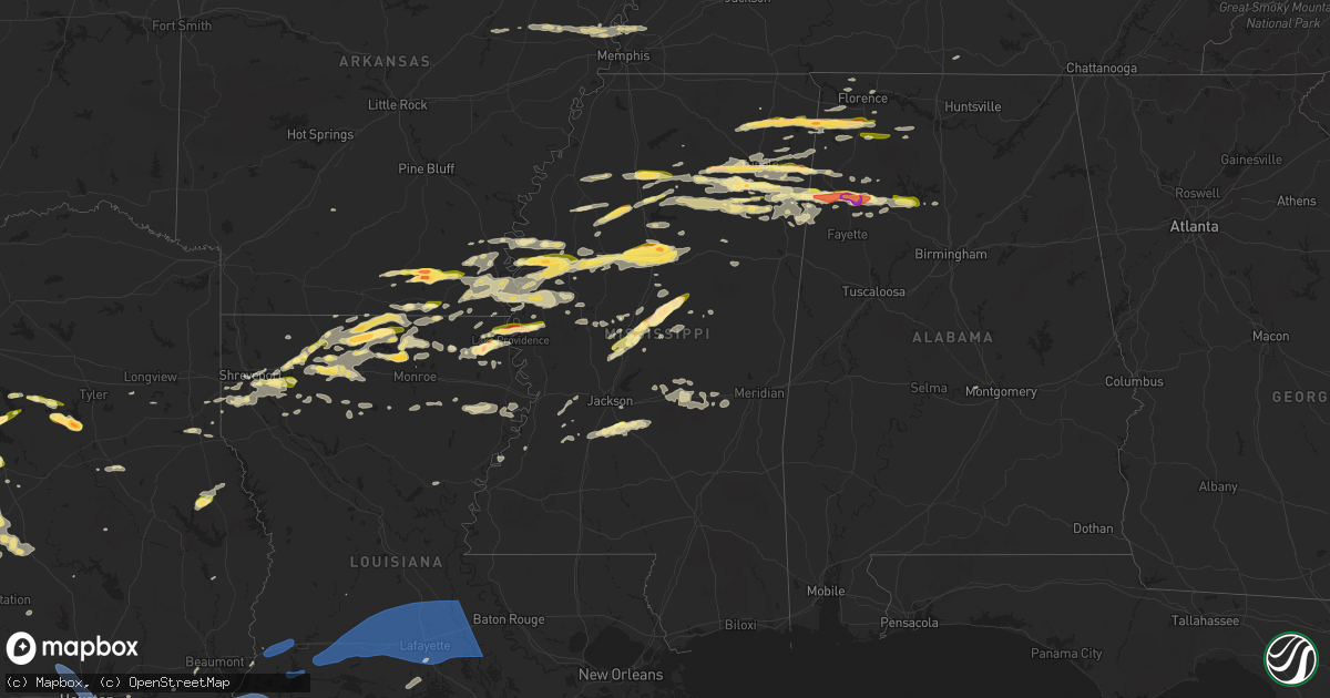
Hail Map in Mississippi on March 23, 2025
Get this storm
March 23 map
$229
one time, instant access
Download today. No call, no setup
Keep the $229
Bought the map and want the full workflow? Apply the entire $229 to a subscription within 7 days. None of it is wasted.
Every map, not just this one
This buys you this map. Subscription and you get every map we run, in the markets you choose from a few cities to whole states to nationwide. Plus real-time alerts the moment a storm fires.
Contact data
Name, contact info, occupancy, even credit band for addresses in the footprint. You go from where it hit to who to call.
Become the source they trust
Unlimited branding weather history reports on demand. You already have the documented answer ready for the property owner, and you are the one who showed up with it.
Property data and RoofTrace estimates
Pull up any address you have got, its value and the exact code rules for that jurisdiction, straight from One Click Code. Then RoofTrace estimates the squares, pitch, and roof value, priced the way you price.
Storm reports in Mississippi
Mississippi
| Date | Description |
|---|---|
| 03/23/20256:59 PM CDT | Report of quarter size hail south of fulton on hwy 25 about a half mile from the interstate. |
| 03/23/20256:57 PM CDT | Corrects previous hail report from 1 n fulton. Delayed report of half dollar size hail in fulton. Time estimated via radar. |
| 03/23/20256:53 PM CDT | Report of quarter size hail west of shannon and north of okolona. |
| 03/23/20256:45 PM CDT | Picture submitted via social media from near pickens. |
| 03/23/20256:44 PM CDT | Quarter size hail report from water valley. Time estimated via radar. |
| 03/23/20256:44 PM CDT | 3 power poles down. |
| 03/23/20256:25 PM CDT | Multiple reports of quarter size hail in sw tupelo near s thomas street and cliff gookin blvd. |
| 03/23/20256:23 PM CDT | Penny to quarter size. |
| 03/23/20255:52 PM CDT | Report of golf ball size hail in bloody springs. |
| 03/23/20255:32 PM CDT | A local report indicates 1.00 inch wind near Burton |
| 03/23/20255:15 PM CDT | Delayed report of multiple trees down along county road 5061 south of booneville. Time estimated via radar. |
| 03/23/20255:15 PM CDT | Report of quarter hail in frankstown. |
| 03/23/20255:10 PM CDT | Quarter size hail report near the booneville airport. |
| 03/22/20259:13 PM CDT | Outbuilding damaged. |
| 03/22/20259:08 PM CDT | Report of a tree down on thornton lane and a few tree limbs down on nash road. Time estimated via radar. |
| 03/22/20258:50 PM CDT | Public report of a tree down. |
| 03/22/20258:50 PM CDT | Golfball size hail fell near duck hill. |
| 03/22/20258:48 PM CDT | Homes in hollandale sustained shingle damage. |
| 03/22/20258:36 PM CDT | A local report indicates 1.00 inch wind near 2 SW Browning |
| 03/22/20258:36 PM CDT | A local report indicates 1.00 inch wind near 5 NNE Erwin |
| 03/22/20258:33 PM CDT | A local report indicates 1.00 inch wind near 2 N Rising Sun |
| 03/22/20258:19 PM CDT | Tree do |
| 03/22/20258:19 PM CDT | Tree down on house reported by local emergency manager. |
| 03/22/20258:17 PM CDT | Corrects previous tstm wnd dmg report from 4 n pyland. Public report of a tree down. |
| 03/22/20258:16 PM CDT | Report of quarter sized hail on hatley detroit road. |
| 03/22/20258:08 PM CDT | Report from mping of ping pong ball size hail. |
| 03/22/20257:48 PM CDT | A local report indicates 1.25 inch wind near 1 SSW Winona |
| 03/22/20257:45 PM CDT | Reported near leland. |
| 03/22/20257:30 PM CDT | Reported at glh airport. |
| 03/22/20257:30 PM CDT | Hail accumulated on the ground. Report via pictures submitted on social media. |
| 03/22/20257:27 PM CDT | A local report indicates 1.25 inch wind near 1 S Carrollton |
| 03/22/20257:25 PM CDT | House along ms hwy 16 damaged by a tornado. Trees and powerlines downed. |
| 03/22/20257:22 PM CDT | Photo of quarter-sized hail between bigbee and carolina. |
| 03/22/20257:20 PM CDT | Nickel to quarter size hail at attala co eoc. |
| 03/22/20257:16 PM CDT | A small vortex formed under a rotating wall cloud. Seen from ms highway 14 on the west side of rolling fork. |
| 03/22/20257:15 PM CDT | A local report indicates 2.00 inch wind near 2 WSW Kosciusko |
| 03/22/20257:11 PM CDT | Report of half dollar hail along hwy 45 near okolona. |
| 03/22/20257:09 PM CDT | Report of quarter size hail in coffeeville. |
| 03/22/20257:04 PM CDT | Social media report of quarter size hail near greenwood. |
| 03/22/20257:00 PM CDT | Report via social media from near florence. |
All States Impacted by Hail Map on March 23, 2025
Cities Impacted by Hail Map on March 23, 2025
- McCrory, AR
- Augusta, AR
- Tell City, IN
- Evanston, IN
- Cherry Valley, AR
- Hickory Ridge, AR
- Cannelton, IN
- Leopold, IN
- Troy, IN
- Wynne, AR
- Parkin, AR
- Dumas, MS
- Pioneer, LA
- Rayville, LA
- Oak Ridge, LA
- Baldwyn, MS
- Derby, IN
- New Albany, MS
- Guntown, MS
- Earle, AR
- Turrell, AR
- Tyronza, AR
- Booneville, MS
- Utica, MS
- Hollandale, MS
- Dermott, AR
- Marietta, MS
- Willow City, TX
- Fredericksburg, TX
- New Site, MS
- Crystal Springs, MS
- Edwards, MS
- Raymond, MS
- Gilmore, AR
- Tishomingo, MS
- Dennis, MS
- Belmont, MS
- Crawfordsville, AR
- Vance, MS
- Lambert, MS
- Millington, TN
- Centerville, TN
- Duck River, TN
- Lake Providence, LA
- Pontotoc, MS
- Randolph, MS
- Marion, AR
- Cherokee, AL
- Russellville, AL
- Red Bay, AL
- Paducah, KY
- Junction, TX
- Harper, TX
- Drew, MS
- Arkansas City, AR
- Rohwer, AR
- McGehee, AR
- Williamsport, TN
- Hampshire, TN
- Santa Fe, TN
- Brookport, IL
- Oak Grove, LA
- Anguilla, MS
- Mayersville, MS
- Rolling Fork, MS
- Glen Allan, MS
- Tutwiler, MS
- Charleston, MS
- Greenville, MS
- Hickory, KY
- Fancy Farm, KY
- Smithland, KY
- Ledbetter, KY
- Franklin, TN
- Enid, MS
- Batesville, MS
- Pope, MS
- Benoit, MS
- Corsicana, TX
- Florence, MS
- Terry, MS
- Columbia, TN
- Thompsons Station, TN
- Tuscumbia, AL
- Fredonia, KY
- Marion, KY
- Grand Rivers, KY
- Calvert City, KY
- Hamburg, AR
- Brentwood, TN
- Portland, AR
- Moorhead, MS
- Dubach, LA
- Homer, LA
- Bernice, LA
- Mayfield, KY
- Antioch, TN
- Nolensville, TN
- Symsonia, KY
- Tupelo, MS
- Oakland, MS
- Hampton, AR
- Mountain Home, TX
- Parkdale, AR
- Boaz, KY
- Belden, MS
- La Vergne, TN
- Canton, MS
- Smyrna, TN
- Arrington, TN
- Burna, KY
- Leland, MS
- Indianola, MS
- Inverness, MS
- Water Valley, MS
- Coffeeville, MS
- Strong, AR
- El Dorado, AR
- Montrose, AR
- Hermitage, TN
- Mount Juliet, TN
- Murfreesboro, TN
- Lebanon, TN
- Houlka, MS
- Pickens, MS
- Itta Bena, MS
- Fulton, KY
- Hickman, KY
- Plantersville, MS
- Vaughan, MS
- Camden, MS
- Bentonia, MS
- Courtland, MS
- Minter City, MS
- Philipp, MS
- Hermitage, AR
- Verona, MS
- Kerens, TX
- Leighton, AL
- Jersey, AR
- East Prairie, MO
- Clinton, KY
- Holcomb, MS
- Minden, LA
- Huttig, AR
- Lake Village, AR
- Harrisville, MS
- Gordonsville, TN
- Carthage, TN
- Brush Creek, TN
- Fulton, MS
- Scobey, MS
- Tillatoba, MS
- Florence, AL
- Sidon, MS
- Greenwood, MS
- Cascilla, MS
- Okolona, MS
- Shannon, MS
- Water Valley, KY
- Mooreville, MS
- Johnson City, TX
- Ruston, LA
- Boyle, MS
- Shaw, MS
- Elmwood, TN
- Nettleton, MS
- Frost, TX
- Stonewall, TX
- Farmington, KY
- Kirksey, KY
- Braxton, MS
- Ingram, TX
- Kerrville, TX
- Oxford, MS
- Sallis, MS
- Purdon, TX
- Groveton, TX
- Wingo, KY
- Sedalia, KY
- Golden, MS
- Fountain Hill, AR
- Goodman, MS
- Arkadelphia, AR
- Murray, KY
- Almo, KY
- San Augustine, TX
- Tremont, MS
- Paris, MS
- Granville, TN
- Watertown, TN
- Pleasant Shade, TN
- Gainesboro, TN
- Houston, MS
- Choudrant, LA
- Banner, MS
- Eustace, TX
- Mabank, TX
- Whitleyville, TN
- Hilham, TN
- Trinidad, TX
- Malakoff, TX
- Kosciusko, MS
- Carrollton, MS
- Pennington, TX
- Amory, MS
- Bruce, MS
- Hamilton, AL
- Coila, MS
- Crossett, AR
- Gibsland, LA
- Farmerville, LA
- Downsville, LA
- Barry, TX
- Brandon, MS
- Mendenhall, MS
- Hazel, KY
- Schlater, MS
- Hye, TX
- Blooming Grove, TX
- Smithville, MS
- Richland, TX
- Athens, TX
- Wortham, TX
- Lufkin, TX
- Spruce Pine, AL
- Aberdeen, MS
- Winona, MS
- Athens, LA
- Big Creek, MS
- Ethel, MS
- Lebanon Junction, KY
- McCarley, MS
- McCool, MS
- Cotton Valley, LA
- Kyle, TX
- Sunflower, MS
- Shreveport, LA
- Calhoun City, MS
- Shepherdsville, KY
- Mount Washington, KY
- Coxs Creek, KY
- Vardaman, MS
- Dawson, TX
- Arcadia, LA
- Doddsville, MS
- Mount Calm, TX
- Buda, TX
- Hubbard, TX
- Leakey, TX
- Taylorsville, KY
- Pittsboro, MS
- Hunt, TX
- Greenwood Springs, MS
- Coolidge, TX
- Comfort, TX
- Detroit, AL
- Clermont, KY
- Center Point, TX
- Iuka, MS
- Sulligent, AL
- Haughton, LA
- Bossier City, LA
- Kilmichael, MS
- Eudora, AR
- Larue, TX
- Murchison, TX
- Marion, LA
- Streetman, TX
- Princeton, LA
- Lisbon, LA
- Lockhart, TX
- Shelbyville, TX
- Beaverton, AL
- Morgantown, KY
- Roundhill, KY
- Brownsville, KY
- Blanco, TX
- Boerne, TX
- Mantachie, MS
- San Marcos, TX
- Brownsboro, TX
- Wilmot, AR
- Jones, LA
- North Carrollton, MS
- Mexia, TX
- Frankston, TX
- Summerfield, LA
- Haynesville, LA
- Simsboro, LA
- Bastrop, LA
- Caneyville, KY
- Bee Spring, KY
- Lawrenceburg, KY
- Fairfield, TX
- Prairie Hill, TX
- Groesbeck, TX
- Lillie, LA
- Mammoth Cave, KY
- Killen, AL
- Vanderpool, TX
- Versailles, KY
- Bloomfield, KY
- Dubberly, LA
- Kendalia, TX
- Elm Grove, LA
- Pipe Creek, TX
- Duck Hill, MS
- Guin, AL
- Stewart, MS
- Chatham, MS
- Town Creek, AL
- Moulton, AL
- Mount Hope, AL
- Winfield, AL
- Brilliant, AL
- Indian Mound, TN
- De Berry, TX
- Cub Run, KY
- Dripping Springs, TX
- Austin, TX
- Junction City, AR
- Spearsville, LA
- Medina, TX
- Palmyra, TN
- Maxwell, TX
- Sterlington, LA
- Prairie, MS
- Eupora, MS
- Sibley, LA
- Belzoni, MS
- Round Mountain, TX
- Teague, TX
- Isola, MS
- Bandera, TX
- Grenada, MS
- Wimberley, TX
- Driftwood, TX
- Bullard, TX
- Jacksonville, TX
- Nauvoo, AL
- Eldridge, AL
- Utopia, TX
- Tarpley, TX
- Doyline, LA
- Dellrose, TN
- Stonewall, LA
- Monroe, LA
- Spring Branch, TX
- Bergheim, TX
- Bear Creek, AL
- Canyon Lake, TX
- Silver City, MS
- Hamilton, MS
- Caledonia, MS
- Grambling, LA
- Buffalo, TX
- Bartlett, TX
- Salado, TX
- Kilgore, TX
- Belton, TX
- Thornton, TX
- Bulverde, TX
- Little River Academy, TX
- Temple, TX
- Kosse, TX
- Jewett, TX
- Carbon Hill, AL
- Fayetteville, TN
- Gattman, MS
- Manchaca, TX
- Jasper, AL
- Keithville, LA
- Maben, MS
- Holland, TX
- D Hanis, TX
- New Braunfels, TX
- Hillsboro, AL
- Trinity, AL
- Rogers, TX
- Vernon, AL
- Helotes, TX
- Del Valle, TX
- Hondo, TX
- San Antonio, TX
- Mathiston, MS
- Rosebud, TX
- Georgetown, TX
- Marquez, TX
- Yazoo City, MS
- Louise, MS
- Carthage, TX
- Gary, TX
- Franklin, TX
- Oakwood, TX
- Fayette, AL
- Bremond, TX
- Frierson, LA
- Tenaha, TX
- Granger, TX
- Jarrell, TX
- Mer Rouge, LA
- Henderson, TX
- Jamestown, LA
- Sturgis, MS
- Ringgold, LA
- Saltillo, MS
- Starkville, MS
- Townley, AL
- Seguin, TX
- Vaiden, MS
- Lexington, MS
- Kingsbury, TX
- Martindale, TX
- Luling, TX
- Joaquin, TX
- West, MS
- Keatchie, LA
- Heflin, LA
- Normangee, TX
- Durant, MS
- Calvert, TX
- Gonzales, TX
- Bremen, AL
- Hanceville, AL
- Vina, AL
- Hearne, TX
- Epps, LA
- Barksdale Afb, LA
- Benton, MS
- Jbsa Lackland, TX
- Madisonville, TX
- Stockdale, TX
- Sutherland Springs, TX
- Transylvania, LA
- Carthage, MS
- La Vernia, TX
- Mangham, LA
- Baskin, LA
- Coushatta, LA
- Rusk, TX
- Quitman, LA
- Floresville, TX
- Alto, TX
- Delhi, LA
- Jonesboro, LA
- Bryan, TX
- Louisville, MS
- Tallulah, LA
- Chatfield, TX
- Winnsboro, LA
- Chatham, LA
- Anderson, TX
- Newellton, LA
- Columbia, LA
- Huntsville, TX
- Pearl, MS
- Pelahatchie, MS
- Morton, MS
- Gore Springs, MS
- Forest, MS
- Lake, MS
- Pulaski, MS
- Vicksburg, MS
- Lorman, MS
- Lawrence, MS
- Newton, MS
- Haleyville, AL
- Port Gibson, MS
- Hickory, MS
- Houston, TX
- Baytown, TX
- Galena Park, TX
- Pasadena, TX
- South Houston, TX
- Pearland, TX
- Webster, TX
- Friendswood, TX
- League City, TX
- Dickinson, TX
- Santa Fe, TX
- Bacliff, TX
- Seabrook, TX
- Kemah, TX
- Texas City, TX
- La Marque, TX
- Galveston, TX
- Port Bolivar, TX
- Prattville, AL
- Anahuac, TX
- Cypress, TX
- Spring, TX
- Tomball, TX
- Jasper, TX
- Winnie, TX
- Jonesville, LA
- Evergreen, AL
- Beaumont, TX
- Port Arthur, TX
- Cameron, LA
- Sabine Pass, TX
- Orange, TX
- Bethany, LA
- Greenwood, LA
- Hackberry, LA
- Lake Charles, LA
- Vinton, LA
- Sulphur, LA
- Iowa, LA
- Bell City, LA
- Abbeville, LA
- Lacassine, LA
- Lake Arthur, LA
- Welsh, LA
- Erath, LA
- Jennings, LA
- Roanoke, LA
- Mermentau, LA
- Morse, LA
- Basile, LA
- Evangeline, LA
- Egan, LA
- Iota, LA
- Estherwood, LA
- Crowley, LA
- Eunice, LA
- Branch, LA
- Rayne, LA
- Kaplan, LA
- Lafayette, LA
- Scott, LA
- Duson, LA
- Church Point, LA
- Youngsville, LA
- Maurice, LA
- Broussard, LA
- Opelousas, LA
- Carencro, LA
- Sunset, LA
- Ville Platte, LA
- Oberlin, LA
- Saint Martinville, LA
- Breaux Bridge, LA
- Arnaudville, LA
- New Iberia, LA
- Port Barre, LA
- Washington, LA
- Krotz Springs, LA
- Palmetto, LA
- Lottie, LA
- Morganza, LA
- Maringouin, LA
- Fordoche, LA
- Grosse Tete, LA
- Melville, LA
- Plaquemine, LA
- Bienville, LA
- Hall Summit, LA
- Castor, LA


