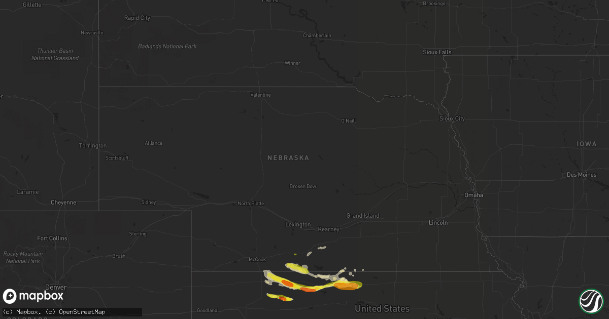
Hail Map in Nebraska on March 23, 2018
Get this storm
March 23 map
$229
one time, instant access
Download today. No call, no setup
Keep the $229
Bought the map and want the full workflow? Apply the entire $229 to a subscription within 7 days. None of it is wasted.
Every map, not just this one
This buys you this map. Subscription and you get every map we run, in the markets you choose from a few cities to whole states to nationwide. Plus real-time alerts the moment a storm fires.
Contact data
Name, contact info, occupancy, even credit band for addresses in the footprint. You go from where it hit to who to call.
Become the source they trust
Unlimited branding weather history reports on demand. You already have the documented answer ready for the property owner, and you are the one who showed up with it.
Property data and RoofTrace estimates
Pull up any address you have got, its value and the exact code rules for that jurisdiction, straight from One Click Code. Then RoofTrace estimates the squares, pitch, and roof value, priced the way you price.
Storm reports in Nebraska
Nebraska
| Date | Description |
|---|---|
| 03/23/20183:15 AM CDT | At 815 PM CDT, a severe thunderstorm was located 9 miles southwest of Stamford, or 16 miles northeast of Norton, moving east at 35 mph. HAZARD...Golf ball size hail and 60 mph wind gusts. SOURCE...Radar indicated. IMPACT...People and animals outdoors will be injured. Expect hail damage to roofs, siding, windows, and vehicles. Expect wind damage to roofs, siding, and trees. Locations impacted include... Alma, Orleans, Stamford, Long Island, Woodruff and Harlan County Dam. |
| 03/22/20187:55 PM CDT | Mostly nickel size hail... A few up to the size of quarters. |
Cities Impacted by Hail Map on March 23, 2018
- Hendley, NE
- Beaver City, NE
- Logan, KS
- Prairie View, KS
- Phillipsburg, KS
- Glade, KS
- Red Cloud, NE
- Norcatur, KS
- Norton, KS
- Kirwin, KS
- Almena, KS
- Athol, KS
- Smith Center, KS
- Lebanon, KS
- Lenora, KS
- Riverton, NE
- Gaylord, KS
- Agra, KS
- Kensington, KS
- Oberlin, KS
- Esbon, KS
- Portis, KS
- Hill City, KS
- Morland, KS
- Imperial, MO
- Arnold, MO
- Long Island, KS
- Stamford, NE
- Jennings, KS
- Selden, KS
- Axtell, NE
- Wilcox, NE
- Holdrege, NE
- Waterloo, IL
- Warrenton, MO
- Dresden, KS
- Oxford, NE
- Orleans, NE
- Danbury, NE
- Mankato, KS
- Auxvasse, MO
- Valmeyer, IL
- Guide Rock, NE
- Clayton, KS
- Edison, NE


