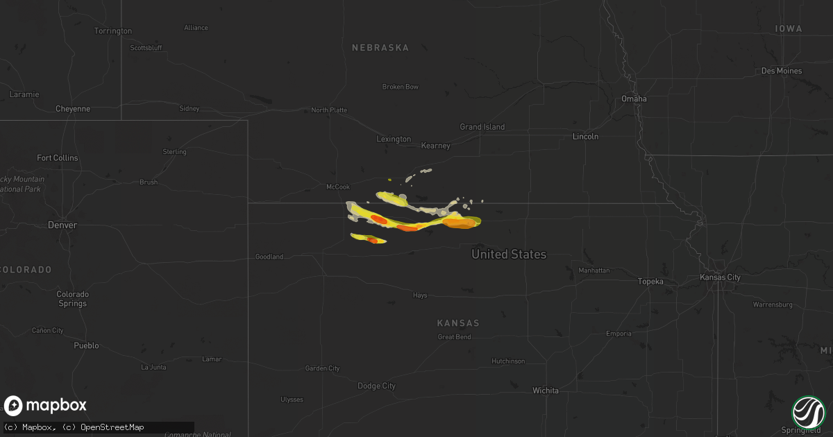
Hail Map on March 23, 2018
Get this storm
March 23 map
$229
one time, instant access
Download today. No call, no setup
Keep the $229
Bought the map and want the full workflow? Apply the entire $229 to a subscription within 7 days. None of it is wasted.
Every map, not just this one
This buys you this map. Subscription and you get every map we run, in the markets you choose from a few cities to whole states to nationwide. Plus real-time alerts the moment a storm fires.
Contact data
Name, contact info, occupancy, even credit band for addresses in the footprint. You go from where it hit to who to call.
Become the source they trust
Unlimited branding weather history reports on demand. You already have the documented answer ready for the property owner, and you are the one who showed up with it.
Property data and RoofTrace estimates
Pull up any address you have got, its value and the exact code rules for that jurisdiction, straight from One Click Code. Then RoofTrace estimates the squares, pitch, and roof value, priced the way you price.
Storm reports
Kansas
| Date | Description |
|---|---|
| 03/23/20189:25 AM CDT | A local report indicates 1.00 inch wind near SMITH CENTER |
| 03/23/20184:42 AM CDT | At 941 PM CDT, a severe thunderstorm was located over Esbon, or 29 miles northwest of Beloit, moving east at 50 mph. This warning replaces the previous warning in effect for Smith County. HAZARD...60 mph wind gusts and half dollar size hail. SOURCE...Radar indicated. IMPACT...Hail damage to vehicles is expected. Expect wind damage to roofs, siding, and trees. Locations impacted include... Mankato, Lebanon, Burr Oak, Esbon, Formoso, Webber, Lovewell State Park and Montrose. |
| 03/23/20183:57 AM CDT | At 856 PM CDT, severe thunderstorms were located along a line extending from near Harlan County Dam to near Agra, moving east at 35 mph. This warning replaces the previous warning for Phillips county. HAZARD...60 mph wind gusts and half dollar size hail. SOURCE...Radar indicated. IMPACT...Hail damage to vehicles is expected. Expect wind damage to roofs, siding, and trees. Locations impacted include... Smith Center, Kensington, Agra, Lebanon, Athol and Bellaire. |
| 03/23/20183:08 AM CDT | At 808 PM CDT, a severe thunderstorm was located 9 miles southeast of Norton, moving east at 45 mph. HAZARD...60 mph wind gusts and quarter size hail. SOURCE...Radar indicated. IMPACT...Hail damage to vehicles is expected. Expect wind damage to roofs, siding, and trees. Locations impacted include... Phillipsburg, Logan, Agra, Kirwin, Prairie View, Glade and Speed. |
| 03/23/20182:53 AM CDT | At 752 PM CDT, a severe thunderstorm was located near Hendley, or 17 miles north of Norton, moving east at 35 mph. HAZARD...60 mph wind gusts and half dollar size hail. SOURCE...Radar indicated. IMPACT...Hail damage to vehicles is expected. Expect wind damage to roofs, siding, and trees. Locations impacted include... Beaver City, Hendley and Hollinger. |
| 03/23/20182:53 AM CDT | At 752 PM CDT, a severe thunderstorm was located 8 miles southeast of Norton, moving east at 65 mph. HAZARD...60 mph wind gusts and quarter size hail. SOURCE...Radar indicated. IMPACT...Hail damage to vehicles is expected. Expect wind damage to roofs, siding, and trees. Locations impacted include... Norton, Almena and Calvert. |
| 03/23/20182:38 AM CDT | At 738 PM CDT, a severe thunderstorm was located 9 miles southeast of Jennings, or 20 miles northeast of Hoxie, moving east at 45 mph. HAZARD...Golf ball size hail and 60 mph wind gusts. SOURCE...Radar indicated. IMPACT...People and animals outdoors will be injured. Expect hail damage to roofs, siding, windows, and vehicles. Expect wind damage to roofs, siding, and trees. Locations impacted include... Lenora, Jennings, Nicodemus, Edmond, Densmore and New Almelo. |
| 03/23/20182:23 AM CDT | At 722 PM CDT, a severe thunderstorm was located 7 miles west of Norcatur, or 11 miles east of Oberlin, moving east at 45 mph. HAZARD...Quarter size hail and wind gusts up to 55 mph. SOURCE...Radar indicated. IMPACT...Hail damage to vehicles is expected. Locations impacted include... Norton, Lenora, Norcatur, Jennings, Clayton, Edmond and Kanona. |
| 03/22/20189:41 PM CDT | A local report indicates 1.00 inch wind near LEBANON |
| 03/22/20189:30 PM CDT | A local report indicates 1.00 inch wind near LEBANON |
| 03/22/20189:25 PM CDT | Corrects previous hail report from smith center. |
| 03/22/20189:22 PM CDT | Report via twitter. Time estimated from radar. |
| 03/22/20189:22 PM CDT | A local report indicates 1.50 inch wind near 1 NW SMITH CENTER |
| 03/22/20189:21 PM CDT | A local report indicates 1.00 inch wind near SMITH CENTER |
| 03/22/20189:20 PM CDT | A local report indicates 1.00 inch wind near SMITH CENTER |
| 03/22/20189:19 PM CDT | Hail was covering the ground. The duration of the hail event was 6 minutes. |
| 03/22/20189:09 PM CDT | A local report indicates 1.00 inch wind near 3 W ATHOL |
| 03/22/20189:06 PM CDT | A local report indicates 1.00 inch wind near KENSINGTON |
| 03/22/20188:44 PM CDT | Penny to quarter size hail. |
| 03/22/20188:40 PM CDT | Via spotter network. |
| 03/22/20188:33 PM CDT | A local report indicates 1.75 inch wind near 3 W GLADE |
| 03/22/20188:28 PM CDT | Mesonet station e3001... Logan. |
| 03/22/20188:15 PM CDT | Initial svr gust. Pk gust of 66 mph occurred at 823 pm. This is a correction to the prvs lsr. |
| 03/22/20188:15 PM CDT | Corrects previous hail report from logan. Picture received of hail. Time estimated from radar. |
| 03/22/20187:58 PM CDT | Asos station hlc... Hill city ks measured a peak wind gust of 63 mph at 658 pm mdt or 758 pm cdt. |
| 03/22/20187:50 PM CDT | A local report indicates 1.00 inch wind near NORTON |
| 03/22/20187:50 PM CDT | Spotter reported quarter size hail just north of lenora at 650 pm mdt. |
| 03/22/20187:48 PM CDT | Numerous ping pong to golfball sized hail |
| 03/22/20187:45 PM CDT | Hail ranged from pea-sized to quarter-sized |
| 03/22/20187:45 PM CDT | A local report indicates 1.00 inch wind near 7 W NEW ALMELO |
| 03/22/20187:40 PM CDT | A local report indicates 1.25 inch wind near 1 W REAGER |
| 03/22/20187:38 PM CDT | Lots of ping pong to golf ball hail. Screens and cars damaged. |
| 03/22/20187:38 PM CDT | Lots of ping pong to golf ball hail. Screens and cars damaged |
| 03/22/20187:35 PM CDT | A local report indicates 1.00 inch wind near NORCATUR |
| 03/22/20187:35 PM CDT | Near the decatur/sheridan county line. Sent via social media. |
Nebraska
| Date | Description |
|---|---|
| 03/23/20183:15 AM CDT | At 815 PM CDT, a severe thunderstorm was located 9 miles southwest of Stamford, or 16 miles northeast of Norton, moving east at 35 mph. HAZARD...Golf ball size hail and 60 mph wind gusts. SOURCE...Radar indicated. IMPACT...People and animals outdoors will be injured. Expect hail damage to roofs, siding, windows, and vehicles. Expect wind damage to roofs, siding, and trees. Locations impacted include... Alma, Orleans, Stamford, Long Island, Woodruff and Harlan County Dam. |
| 03/22/20187:55 PM CDT | Mostly nickel size hail... A few up to the size of quarters. |
Colorado
| Date | Description |
|---|---|
| 03/22/20188:17 PM CDT | At 115 PM MDT, strong outflow winds from a previous storm was located 7 miles southeast of Limon, moving southeast at 45 mph. HAZARD...60 mph wind gusts. SOURCE...Radar indicated. IMPACT...Expect damage to roofs, siding, and trees. Locations impacted include... Limon, Hugo, Genoa, Boyero and Karval. |
Cities Impacted by Hail Map on March 23, 2018
- Hendley, NE
- Beaver City, NE
- Logan, KS
- Prairie View, KS
- Phillipsburg, KS
- Glade, KS
- Red Cloud, NE
- Norcatur, KS
- Norton, KS
- Kirwin, KS
- Almena, KS
- Athol, KS
- Smith Center, KS
- Lebanon, KS
- Lenora, KS
- Riverton, NE
- Gaylord, KS
- Agra, KS
- Kensington, KS
- Oberlin, KS
- Esbon, KS
- Portis, KS
- Hill City, KS
- Morland, KS
- Imperial, MO
- Arnold, MO
- Long Island, KS
- Stamford, NE
- Jennings, KS
- Selden, KS
- Axtell, NE
- Wilcox, NE
- Holdrege, NE
- Waterloo, IL
- Warrenton, MO
- Dresden, KS
- Oxford, NE
- Orleans, NE
- Danbury, NE
- Mankato, KS
- Auxvasse, MO
- Valmeyer, IL
- Guide Rock, NE
- Clayton, KS
- Edison, NE