Hail Map in Indiana on March 23, 2012
Get this storm
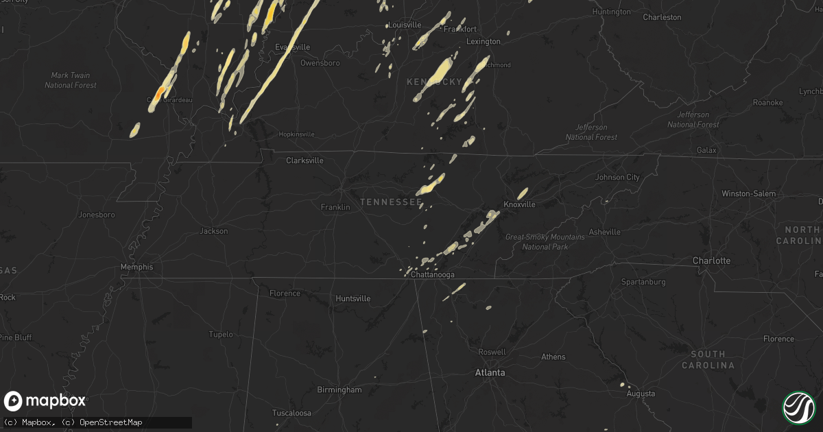
March 23 map
$229
one time, instant access
Download today. No call, no setup
Keep the $229
Bought the map and want the full workflow? Apply the entire $229 to a subscription within 7 days. None of it is wasted.
Every map, not just this one
This buys you this map. Subscription and you get every map we run, in the markets you choose from a few cities to whole states to nationwide. Plus real-time alerts the moment a storm fires.
Contact data
Name, contact info, occupancy, even credit band for addresses in the footprint. You go from where it hit to who to call.
Become the source they trust
Unlimited branding weather history reports on demand. You already have the documented answer ready for the property owner, and you are the one who showed up with it.
Property data and RoofTrace estimates
Pull up any address you have got, its value and the exact code rules for that jurisdiction, straight from One Click Code. Then RoofTrace estimates the squares, pitch, and roof value, priced the way you price.
Storm reports in Indiana
Indiana
| Date | Description |
|---|---|
| 03/23/20126:56 PM CDT | A local report indicates 1.00 inch wind near BEANBLOSSOM |
| 03/23/20126:54 PM CDT | A local report indicates 1.00 inch wind near NASHVILLE |
| 03/23/20125:50 PM CDT | A local report indicates 1.00 inch wind near MOROCCO |
| 03/23/20125:45 PM CDT | Hail lasted about 10 minutes. |
| 03/23/20125:38 PM CDT | A local report indicates 1.25 inch wind near BLOOMINGTON |
| 03/23/20125:23 PM CDT | A local report indicates 1.00 inch wind near 4 NW HARRODSBURG |
| 03/23/20124:32 PM CDT | A local report indicates 1.00 inch wind near 5 S ODON |
| 03/23/20123:54 PM CDT | Relayed from nwschat |
| 03/23/20123:45 PM CDT | Hail is covering the ground |
| 03/23/20123:39 PM CDT | Report of a brief tornado touchdown in an open field north of center square. Tornado then lifted and the funnel cloud continued moving northeast. |
| 03/23/20123:31 PM CDT | A local report indicates 1.00 inch wind near CARLISLE |
| 03/23/20123:29 PM CDT | A local report indicates 1.00 inch wind near 1 W FREELANDVILLE |
| 03/22/201210:30 PM CDT | A local report indicates 1.75 inch wind near 1 SW MUNCIE |
| 03/22/201210:20 PM CDT | A local report indicates 1.00 inch wind near 2 SE MUNCIE |
| 03/22/201210:15 PM CDT | A local report indicates 1.25 inch wind near MUNCIE |
| 03/22/20129:41 PM CDT | Spotter reported nickel to quarter size hail falling |
| 03/22/20128:25 PM CDT | A local report indicates 1.00 inch wind near FAIRLAND |
| 03/22/20127:15 PM CDT | A local report indicates 1.00 inch wind near S SPEARSVILLE |
| 03/22/20127:10 PM CDT | Tree limbs and other litter at weber hill and east washington |
| 03/22/20127:00 PM CDT | Hailstones found on ground a while after storm passage |
All States Impacted by Hail Map on March 23, 2012
Cities Impacted by Hail Map on March 23, 2012
- Iuka, IL
- Salem, IL
- Talking Rock, GA
- Ellijay, GA
- Manchester, OH
- Maysville, KY
- Vine Grove, KY
- Ekron, KY
- Mayfield, KY
- Shepherdsville, KY
- Cape Girardeau, MO
- Jackson, MO
- Decatur, TN
- Niota, TN
- Evensville, TN
- Athens, TN
- Corryton, TN
- Knoxville, TN
- Luttrell, TN
- Eddyville, IL
- Milford, IL
- Rineyville, KY
- Elizabethtown, KY
- Cecilia, KY
- Parkersburg, IL
- Albion, IL
- West Salem, IL
- Golden Gate, IL
- Ellery, IL
- Mattoon, IL
- Humboldt, IL
- West York, IL
- Annapolis, IL
- Puxico, MO
- Dexter, MO
- Dudley, MO
- Bloomfield, MO
- Whitewater, MO
- Carmi, IL
- Sullivan, IN
- Merom, IN
- Waynesburg, KY
- Kings Mountain, KY
- Ralph, AL
- Watson, IL
- Effingham, IL
- Grand Tower, IL
- Altenburg, MO
- Jasper, TN
- South Pittsburg, TN
- Sequatchie, TN
- Linton, IN
- Carlisle, IN
- Dugger, IN
- Odum, GA
- Thomasboro, IL
- Gifford, IL
- Rantoul, IL
- Hilham, TN
- Chattanooga, TN
- Bloomfield, IN
- Solsberry, IN
- West Union, OH
- Morocco, IN
- Paducah, KY
- Symsonia, KY
- Boaz, KY
- Ledbetter, KY
- North Middletown, KY
- Paris, KY
- Oran, MO
- Wolf Lake, IL
- Chaffee, MO
- Advance, MO
- Climax, GA
- Bainbridge, GA
- Oakland City, IN
- Rickman, TN
- Crawford, TN
- Cookeville, TN
- Monterey, TN
- Nicholasville, KY
- Richmond, KY
- Lancaster, KY
- Science Hill, KY
- Louisville, KY
- Mount Washington, KY
- Finchville, KY
- Coxs Creek, KY
- Taylorsville, KY
- Fisherville, KY
- Montgomery, IN
- Allendale, IL
- Owensville, IN
- Mount Carmel, IL
- Sumner, IL
- Bellmont, IL
- Crossville, IL
- Grayville, IL
- Browns, IL
- Griffin, IN
- Summersville, KY
- Greensburg, KY
- Heltonville, IN
- Norman, IN
- Bloomington, IN
- Mackville, KY
- Springfield, KY
- Willisburg, KY
- Campbellsville, KY
- Lebanon, KY
- Birchwood, TN
- Nashville, IN
- Unionville, IN
- Stonefort, IL
- Carrier Mills, IL
- Urbana, IL
- Tolono, IL
- Philo, IL
- Norris City, IL
- Harrisburg, IL
- Omaha, IL
- Equality, IL
- Ridgway, IL
- Stilesville, IN
- Coatesville, IN
- Stanford, KY
- Martinsville, IN
- Raleigh, IL
- Galatia, IL
- Franklin, IN
- Farmland, IN
- Ridgeville, IN
- Somerville, OH
- Hamilton, OH
- Seven Mile, OH
- Trenton, OH
- Otwell, IN
- Crane, IN
- Winslow, IN
- Calvert City, KY
- Springville, IN
- Cannelburg, IN
- Owensburg, IN
- Clay, KY
- Evansville, IN
- Washington, IN
- Marion, KY
- Corydon, KY
- Grand Rivers, KY
- Odon, IN
- Tiline, KY
- Salem, KY
- Waverly, KY
- Loogootee, IN
- Elberfeld, IN
- Haubstadt, IN
- Morganfield, KY
- Petersburg, IN
- Chandler, IN
- Smithland, KY
- Sturgis, KY
- Henderson, KY
- Muncie, IN
- Selma, IN
- Greenfield, IN
- Laconia, IN
- Villa Grove, IL
- Pesotum, IL
- Sidney, IL
- Tuscola, IL
- Burnside, KY
- Saint Joseph, IL
- Penfield, IL
- West Point, KY
- Elizabeth, IN
- Brandenburg, KY
- Muldraugh, KY
- Wellington, IL
- Hoopeston, IL
- Kingston, TN
- Loudon, TN
- Murphysboro, IL
- Shelburn, IN
- Lawrenceville, IL
- Bicknell, IN
- Edwardsport, IN
- Oaktown, IN
- Coalmont, IN
- Jasonville, IN
- Flat Rock, IL
- Clay City, IN
- Lewis, IN
- Bruceville, IN
- Frankfort, KY
- Fort Branch, IN
- Lynnville, IN
- Mulkeytown, IL
- Benton, IL
- Christopher, IL
- Monticello, KY
- Texico, IL
- Bluford, IL
- Mount Vernon, IL
- Johnsonville, IL
- Du Quoin, IL
- Elkville, IL
- Vergennes, IL
- Tamaroa, IL
- Burnt Prairie, IL
- Sparta, TN
- Gravel Switch, KY
- Harrodsburg, KY
- Nancy, KY
- Armstrong, IL
- Claxton, GA
- Register, GA
- Mason, IL
- Spencer, TN
- Pikeville, TN
- Terre Haute, IN
- Farmersburg, IN
- Claremont, IL
- Mill Shoals, IL
- Calhoun, IL
- Olney, IL
- Fairfield, IL
- Albany, KY
- Fairland, IN
- Fountaintown, IN
- Shelbyville, IN
- Boggstown, IN
- New Palestine, IN
- Needham, IN
- Corydon, IN
- Jamestown, KY
- Columbia, KY
- Simpson, IL
- Golconda, IL
- Charlottesville, IN
- Middleburg, KY
- Yosemite, KY
- Eldorado, IL
- Ozark, IL
- Sheldon, IL
- New Castle, IN
- Middletown, IN
- Shirley, IN
- Nineveh, IN
- Morgantown, IN
- Trafalgar, IN
- Salem, IN
- Ragland, AL
- Livingston, TN
- Russell Springs, KY
- Marshall, IL
- Hilliard, FL
- Coolidge, GA
- Screven, GA
- Jesup, GA
- Enfield, IL
- Alpine, TN
- Kentland, IN
- Brook, IN
- Thompsonville, IL
- Tompkinsville, KY
- Burkesville, KY
- Reidsville, GA
- Collins, GA
- Philadelphia, TN
- Sweetwater, TN
- Lenoir City, TN
- Amo, IN
- North Vernon, IN
- Paris Crossing, IN
- Commiskey, IN
- Metropolis, IL
- Salvisa, KY
- Bedford, IN
- Greencastle, IN
- Saint Francisville, IL
- Neoga, IL
- Gays, IL
- Windsor, IL
- Glens Fork, KY
- Paris, IL
- Lawrenceburg, KY
- Daleville, IN
- Yorktown, IN
- Albany, IN
- Hustonville, KY
- Defuniak Springs, FL
- Crandall, GA
- Chatsworth, GA
- Dalton, GA
- Broughton, IL
- New Burnside, IL
- Grantsburg, IL
- Shelbyville, KY
- Eminence, KY
- Pleasureville, KY
- Pekin, IN
- Lyons, GA
- Wilkinson, IN
- Knightstown, IN
- Markleville, IN
- Eubank, KY
- Cincinnati, OH
- Indianapolis, IN
- Greenwood, IN
- Morristown, IN
- Carthage, IN
- Appling, GA
- West Union, IL
- Elizabethtown, IL
- Herod, IL
- Black, AL
- Hartford, AL
- Springport, IN
- Kennard, IN
- Mooreland, IN
- Edinburgh, IN
- Whiteland, IN
- Parker City, IN
- Stearns, KY
- Thomasville, GA
- Flag Pond, TN
- Ellettsville, IN
- Gosport, IN
- Signal Mountain, TN
- Whitwell, TN
- Soddy Daisy, TN
- Estill, SC
- Garnett, SC
- Pineland, SC
- Dunlap, TN
- Rome, GA
- Indianola, IL
- Metcalf, IL
- Lupton City, TN
- Hixson, TN
- Brownstown, IN
- Freetown, IN
- Fredericksburg, IN
- Danville, KY
- Allred, TN
- Baxter, TN
- Wilder, TN
- Georgetown, TN
- Palmyra, IN
- Frohna, MO
- Gorham, IL
- Pomona, IL
- Jamestown, TN
- Pall Mall, TN
- Glendale, KY
- Glennville, GA
- Dayton, TN
- Sale Creek, TN
- Springfield, GA
- Clyo, GA
- West Frankfort, IL
- Borden, IN
- Seymour, IN
- Hutsonville, IL
- Palestine, IL
- Benton, KY
- Rocky Face, GA
- La Fayette, GA
- Medora, IN
- Metter, GA
- Warsaw, KY
- Glencoe, KY
- Bagdad, KY
- Simpsonville, KY
- Bethlehem, KY
- Raywick, KY
- Scottsburg, IN
- Keenes, IL
- Rossville, IL
- Dillard, GA
- Plainville, GA
- Adairsville, GA
- Ludowici, GA
- Marshall, IN
- Sewanee, TN
- Herscher, IL
- Williamsport, IN
- Surrency, GA
- Middletown, OH
- Opdyke, IL
- Wing, AL
- Chrisman, IL
- Rockville, IN
- Decker, IN
- Patoka, IN
- Royalton, IL
- Georgetown, IN
- Baxley, GA
- Guyton, GA
- Liberty, KY
- Dunnville, KY
- Scheller, IL
- Pendleton, IN
- Evans, GA
- Laurel Hill, FL
- Lexington, KY
- Coalmont, TN
- Arcola, IL
- Garfield, KY
- Big Clifty, KY
- Calhoun, TN
- Riceville, TN
- Austin, IN
- Crothersville, IN
- Brookport, IL
- Bartow, GA
- Davisboro, GA


