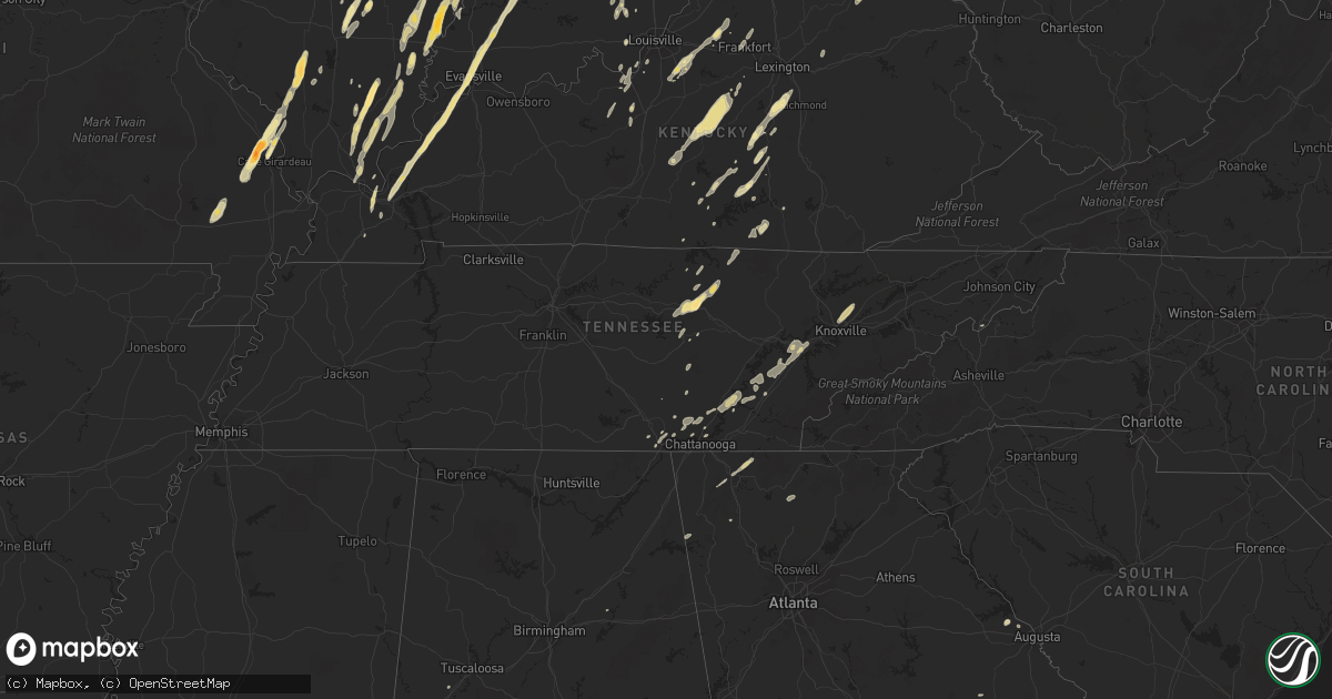
Hail Map in Illinois on March 23, 2012
Get this storm
March 23 map
$229
one time, instant access
Download today. No call, no setup
Keep the $229
Bought the map and want the full workflow? Apply the entire $229 to a subscription within 7 days. None of it is wasted.
Every map, not just this one
This buys you this map. Subscription and you get every map we run, in the markets you choose from a few cities to whole states to nationwide. Plus real-time alerts the moment a storm fires.
Contact data
Name, contact info, occupancy, even credit band for addresses in the footprint. You go from where it hit to who to call.
Become the source they trust
Unlimited branding weather history reports on demand. You already have the documented answer ready for the property owner, and you are the one who showed up with it.
Property data and RoofTrace estimates
Pull up any address you have got, its value and the exact code rules for that jurisdiction, straight from One Click Code. Then RoofTrace estimates the squares, pitch, and roof value, priced the way you price.
Storm reports in Illinois
Illinois
| Date | Description |
|---|---|
| 03/23/20124:52 PM CDT | A local report indicates 1.00 inch wind near HOOPESTON |
| 03/23/20124:46 PM CDT | A local report indicates 60 MPH wind near HENNING |
| 03/23/20124:15 PM CDT | Siding peeled away from building in downtown area. |
| 03/23/20124:10 PM CDT | Spotters reported large pine tree uprooted. |
| 03/23/20123:20 PM CDT | A local report indicates 1.00 inch wind near MARTINSVILLE |
| 03/23/20123:15 PM CDT | A local report indicates 1.00 inch wind near MARTINSVILLE |
| 03/23/20122:20 PM CDT | A local report indicates 1.75 inch wind near BELLMONT |
| 03/23/20122:16 PM CDT | Spotter had to pull over due to large hail on route 15. |
| 03/23/20122:15 PM CDT | Trees blown down. |
| 03/23/20122:12 PM CDT | A local report indicates 1.00 inch wind near BELLMONT |
| 03/23/20121:57 PM CDT | Tornado briefly touched down 2 miles southeast of carter. |
| 03/23/20121:57 PM CDT | Tornado briefly touched down 3 miles south of iuka. |
| 03/23/20121:35 PM CDT | A local report indicates 1.25 inch wind near CARMI |
| 03/23/20121:31 PM CDT | A local report indicates 1.00 inch wind near CARMI |
| 03/23/20121:26 PM CDT | A local report indicates 1.75 inch wind near 2 WSW ETNA |
| 03/23/20121:10 PM CDT | A local report indicates 1.00 inch wind near EFFINGHAM |
| 03/23/20121:09 PM CDT | A local report indicates 1.75 inch wind near 1 S EFFINGHAM |
| 03/23/201212:47 PM CDT | A local report indicates 1.75 inch wind near DU QUOIN |
| 03/23/201212:46 PM CDT | A local report indicates 1.50 inch wind near DU QUOIN |
| 03/23/201212:42 PM CDT | Brief rope tornado touchdown and golf ball size hail |
| 03/23/201212:32 PM CDT | Just north of siu carbondale airport. Brief touchdown and it went back up. |
| 03/23/201212:30 PM CDT | Brief touchdown just outside the city limits of dowell. It touched down and then went back up into the clouds. |
| 03/23/201212:30 PM CDT | Public report relayed by law enforcement of a tornado near truax and trayer road. |
| 03/23/201212:26 PM CDT | A local report indicates 1.75 inch wind near 2 NW HARRISBURG |
| 03/23/201212:24 PM CDT | The following is the preliminary damage assessment for jackson county illinois. * event type.........ef1 tornado * event date.........friday march 23 2012 * event time. |
All States Impacted by Hail Map on March 23, 2012
Cities Impacted by Hail Map on March 23, 2012
- Iuka, IL
- Salem, IL
- Talking Rock, GA
- Ellijay, GA
- Manchester, OH
- Maysville, KY
- Vine Grove, KY
- Ekron, KY
- Mayfield, KY
- Shepherdsville, KY
- Cape Girardeau, MO
- Jackson, MO
- Decatur, TN
- Niota, TN
- Evensville, TN
- Athens, TN
- Corryton, TN
- Knoxville, TN
- Luttrell, TN
- Eddyville, IL
- Milford, IL
- Rineyville, KY
- Elizabethtown, KY
- Cecilia, KY
- Parkersburg, IL
- Albion, IL
- West Salem, IL
- Golden Gate, IL
- Ellery, IL
- Mattoon, IL
- Humboldt, IL
- West York, IL
- Annapolis, IL
- Puxico, MO
- Dexter, MO
- Dudley, MO
- Bloomfield, MO
- Whitewater, MO
- Carmi, IL
- Sullivan, IN
- Merom, IN
- Waynesburg, KY
- Kings Mountain, KY
- Ralph, AL
- Watson, IL
- Effingham, IL
- Grand Tower, IL
- Altenburg, MO
- Jasper, TN
- South Pittsburg, TN
- Sequatchie, TN
- Linton, IN
- Carlisle, IN
- Dugger, IN
- Odum, GA
- Thomasboro, IL
- Gifford, IL
- Rantoul, IL
- Hilham, TN
- Chattanooga, TN
- Bloomfield, IN
- Solsberry, IN
- West Union, OH
- Morocco, IN
- Paducah, KY
- Symsonia, KY
- Boaz, KY
- Ledbetter, KY
- North Middletown, KY
- Paris, KY
- Oran, MO
- Wolf Lake, IL
- Chaffee, MO
- Advance, MO
- Climax, GA
- Bainbridge, GA
- Oakland City, IN
- Rickman, TN
- Crawford, TN
- Cookeville, TN
- Monterey, TN
- Nicholasville, KY
- Richmond, KY
- Lancaster, KY
- Science Hill, KY
- Louisville, KY
- Mount Washington, KY
- Finchville, KY
- Coxs Creek, KY
- Taylorsville, KY
- Fisherville, KY
- Montgomery, IN
- Allendale, IL
- Owensville, IN
- Mount Carmel, IL
- Sumner, IL
- Bellmont, IL
- Crossville, IL
- Grayville, IL
- Browns, IL
- Griffin, IN
- Summersville, KY
- Greensburg, KY
- Heltonville, IN
- Norman, IN
- Bloomington, IN
- Mackville, KY
- Springfield, KY
- Willisburg, KY
- Campbellsville, KY
- Lebanon, KY
- Birchwood, TN
- Nashville, IN
- Unionville, IN
- Stonefort, IL
- Carrier Mills, IL
- Urbana, IL
- Tolono, IL
- Philo, IL
- Norris City, IL
- Harrisburg, IL
- Omaha, IL
- Equality, IL
- Ridgway, IL
- Stilesville, IN
- Coatesville, IN
- Stanford, KY
- Martinsville, IN
- Raleigh, IL
- Galatia, IL
- Franklin, IN
- Farmland, IN
- Ridgeville, IN
- Somerville, OH
- Hamilton, OH
- Seven Mile, OH
- Trenton, OH
- Otwell, IN
- Crane, IN
- Winslow, IN
- Calvert City, KY
- Springville, IN
- Cannelburg, IN
- Owensburg, IN
- Clay, KY
- Evansville, IN
- Washington, IN
- Marion, KY
- Corydon, KY
- Grand Rivers, KY
- Odon, IN
- Tiline, KY
- Salem, KY
- Waverly, KY
- Loogootee, IN
- Elberfeld, IN
- Haubstadt, IN
- Morganfield, KY
- Petersburg, IN
- Chandler, IN
- Smithland, KY
- Sturgis, KY
- Henderson, KY
- Muncie, IN
- Selma, IN
- Greenfield, IN
- Laconia, IN
- Villa Grove, IL
- Pesotum, IL
- Sidney, IL
- Tuscola, IL
- Burnside, KY
- Saint Joseph, IL
- Penfield, IL
- West Point, KY
- Elizabeth, IN
- Brandenburg, KY
- Muldraugh, KY
- Wellington, IL
- Hoopeston, IL
- Kingston, TN
- Loudon, TN
- Murphysboro, IL
- Shelburn, IN
- Lawrenceville, IL
- Bicknell, IN
- Edwardsport, IN
- Oaktown, IN
- Coalmont, IN
- Jasonville, IN
- Flat Rock, IL
- Clay City, IN
- Lewis, IN
- Bruceville, IN
- Frankfort, KY
- Fort Branch, IN
- Lynnville, IN
- Mulkeytown, IL
- Benton, IL
- Christopher, IL
- Monticello, KY
- Texico, IL
- Bluford, IL
- Mount Vernon, IL
- Johnsonville, IL
- Du Quoin, IL
- Elkville, IL
- Vergennes, IL
- Tamaroa, IL
- Burnt Prairie, IL
- Sparta, TN
- Gravel Switch, KY
- Harrodsburg, KY
- Nancy, KY
- Armstrong, IL
- Claxton, GA
- Register, GA
- Mason, IL
- Spencer, TN
- Pikeville, TN
- Terre Haute, IN
- Farmersburg, IN
- Claremont, IL
- Mill Shoals, IL
- Calhoun, IL
- Olney, IL
- Fairfield, IL
- Albany, KY
- Fairland, IN
- Fountaintown, IN
- Shelbyville, IN
- Boggstown, IN
- New Palestine, IN
- Needham, IN
- Corydon, IN
- Jamestown, KY
- Columbia, KY
- Simpson, IL
- Golconda, IL
- Charlottesville, IN
- Middleburg, KY
- Yosemite, KY
- Eldorado, IL
- Ozark, IL
- Sheldon, IL
- New Castle, IN
- Middletown, IN
- Shirley, IN
- Nineveh, IN
- Morgantown, IN
- Trafalgar, IN
- Salem, IN
- Ragland, AL
- Livingston, TN
- Russell Springs, KY
- Marshall, IL
- Hilliard, FL
- Coolidge, GA
- Screven, GA
- Jesup, GA
- Enfield, IL
- Alpine, TN
- Kentland, IN
- Brook, IN
- Thompsonville, IL
- Tompkinsville, KY
- Burkesville, KY
- Reidsville, GA
- Collins, GA
- Philadelphia, TN
- Sweetwater, TN
- Lenoir City, TN
- Amo, IN
- North Vernon, IN
- Paris Crossing, IN
- Commiskey, IN
- Metropolis, IL
- Salvisa, KY
- Bedford, IN
- Greencastle, IN
- Saint Francisville, IL
- Neoga, IL
- Gays, IL
- Windsor, IL
- Glens Fork, KY
- Paris, IL
- Lawrenceburg, KY
- Daleville, IN
- Yorktown, IN
- Albany, IN
- Hustonville, KY
- Defuniak Springs, FL
- Crandall, GA
- Chatsworth, GA
- Dalton, GA
- Broughton, IL
- New Burnside, IL
- Grantsburg, IL
- Shelbyville, KY
- Eminence, KY
- Pleasureville, KY
- Pekin, IN
- Lyons, GA
- Wilkinson, IN
- Knightstown, IN
- Markleville, IN
- Eubank, KY
- Cincinnati, OH
- Indianapolis, IN
- Greenwood, IN
- Morristown, IN
- Carthage, IN
- Appling, GA
- West Union, IL
- Elizabethtown, IL
- Herod, IL
- Black, AL
- Hartford, AL
- Springport, IN
- Kennard, IN
- Mooreland, IN
- Edinburgh, IN
- Whiteland, IN
- Parker City, IN
- Stearns, KY
- Thomasville, GA
- Flag Pond, TN
- Ellettsville, IN
- Gosport, IN
- Signal Mountain, TN
- Whitwell, TN
- Soddy Daisy, TN
- Estill, SC
- Garnett, SC
- Pineland, SC
- Dunlap, TN
- Rome, GA
- Indianola, IL
- Metcalf, IL
- Lupton City, TN
- Hixson, TN
- Brownstown, IN
- Freetown, IN
- Fredericksburg, IN
- Danville, KY
- Allred, TN
- Baxter, TN
- Wilder, TN
- Georgetown, TN
- Palmyra, IN
- Frohna, MO
- Gorham, IL
- Pomona, IL
- Jamestown, TN
- Pall Mall, TN
- Glendale, KY
- Glennville, GA
- Dayton, TN
- Sale Creek, TN
- Springfield, GA
- Clyo, GA
- West Frankfort, IL
- Borden, IN
- Seymour, IN
- Hutsonville, IL
- Palestine, IL
- Benton, KY
- Rocky Face, GA
- La Fayette, GA
- Medora, IN
- Metter, GA
- Warsaw, KY
- Glencoe, KY
- Bagdad, KY
- Simpsonville, KY
- Bethlehem, KY
- Raywick, KY
- Scottsburg, IN
- Keenes, IL
- Rossville, IL
- Dillard, GA
- Plainville, GA
- Adairsville, GA
- Ludowici, GA
- Marshall, IN
- Sewanee, TN
- Herscher, IL
- Williamsport, IN
- Surrency, GA
- Middletown, OH
- Opdyke, IL
- Wing, AL
- Chrisman, IL
- Rockville, IN
- Decker, IN
- Patoka, IN
- Royalton, IL
- Georgetown, IN
- Baxley, GA
- Guyton, GA
- Liberty, KY
- Dunnville, KY
- Scheller, IL
- Pendleton, IN
- Evans, GA
- Laurel Hill, FL
- Lexington, KY
- Coalmont, TN
- Arcola, IL
- Garfield, KY
- Big Clifty, KY
- Calhoun, TN
- Riceville, TN
- Austin, IN
- Crothersville, IN
- Brookport, IL
- Bartow, GA
- Davisboro, GA


