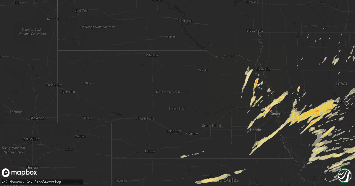
Hail Map in Nebraska on March 22, 2011
Get this storm
March 22 map
$229
one time, instant access
Download today. No call, no setup
Keep the $229
Bought the map and want the full workflow? Apply the entire $229 to a subscription within 7 days. None of it is wasted.
Every map, not just this one
This buys you this map. Subscription and you get every map we run, in the markets you choose from a few cities to whole states to nationwide. Plus real-time alerts the moment a storm fires.
Contact data
Name, contact info, occupancy, even credit band for addresses in the footprint. You go from where it hit to who to call.
Become the source they trust
Unlimited branding weather history reports on demand. You already have the documented answer ready for the property owner, and you are the one who showed up with it.
Property data and RoofTrace estimates
Pull up any address you have got, its value and the exact code rules for that jurisdiction, straight from One Click Code. Then RoofTrace estimates the squares, pitch, and roof value, priced the way you price.
Storm reports in Nebraska
Nebraska
| Date | Description |
|---|---|
| 03/22/20114:43 PM CDT | A local report indicates a tornado near 6 S CRAIG |
| 03/22/20114:39 PM CDT | A local report indicates 1.25 inch wind near 2 E FORT CALHOUN |
| 03/22/20114:31 PM CDT | A local report indicates 1.75 inch wind near PENDER |
| 03/22/20114:30 PM CDT | Hail just slightly smaller than tennis ball size |
| 03/22/20114:16 PM CDT | Ground almost completely covered with hail. The hail lasted for around 5 minutes. Updated this report - found some hail up to golfball size. Winds estimated 50 mph plus |
| 03/22/20114:00 PM CDT | All of the vinyl siding ripped off the side of a house and 2 large sliding doors on a shed blown off of their tracks. Gusts estimated at 60 mph. Dime size hail covered |
| 03/22/20113:45 PM CDT | Winds estimated up to 60 mph and half inch hail. |
| 03/22/20113:45 PM CDT | A local report indicates 1.50 inch wind near 3 ENE WAYNE |
| 03/22/20113:38 PM CDT | Hail up to quarter size reported in wayne to 1 mile east of town...hail was from 332 to 338 pm. |
| 03/22/20113:35 PM CDT | A local report indicates 1.00 inch wind near 4 N RAYMOND |
| 03/22/20113:30 PM CDT | A local report indicates 1.00 inch wind near 2 N MALCOLM |
All States Impacted by Hail Map on March 22, 2011
Cities Impacted by Hail Map on March 22, 2011
- Dumont, IA
- Indianola, IA
- Saint Charles, IA
- Blue Earth, MN
- Mystic, IA
- Moravia, IA
- Centerville, IA
- Bancroft, IA
- New Albin, IA
- Eitzen, MN
- Adair, IA
- Anita, IA
- Pattonsburg, MO
- Valparaiso, NE
- Raymond, NE
- Marshalltown, IA
- Bevier, MO
- Excello, MO
- Callao, MO
- Villisca, IA
- Red Oak, IA
- Dixon, NE
- Stanton, NE
- Baxter, IA
- Melbourne, IA
- Newton, IA
- Cylinder, IA
- Ringsted, IA
- Ceresco, NE
- Forest City, IA
- Glen Elder, KS
- Beloit, KS
- Tipton, KS
- Runnells, IA
- Milan, MO
- Emerson, IA
- Elliott, IA
- Rayville, MO
- Lawson, MO
- Malvern, IA
- Glenwood, IA
- Tabor, IA
- Winterset, IA
- Garland, NE
- Pleasant Dale, NE
- Malcolm, NE
- Griswold, IA
- Dougherty, IA
- Sheffield, IA
- Rockwell, IA
- Galt, MO
- Kirksville, MO
- Humphreys, MO
- Green City, MO
- Greentop, MO
- Harris, MO
- Novinger, MO
- Green Castle, MO
- Pollock, MO
- Concord, NE
- Allen, NE
- Wakefield, NE
- Pilger, NE
- Wayne, NE
- King City, MO
- Woolstock, IA
- Clarion, IA
- Westside, IA
- Manning, IA
- Adams, MN
- Elkton, MN
- Omaha, NE
- Blair, NE
- Creston, IA
- Chillicothe, MO
- Fort Calhoun, NE
- Bennington, NE
- Washington, NE
- Kennard, NE
- Elkhorn, NE
- Valley, NE
- Ridgeway, IA
- Calmar, IA
- Cresco, IA
- Beatrice, NE
- Powersville, MO
- West Point, NE
- Walthill, NE
- Bedford, IA
- Burr, NE
- Dunbar, NE
- Nebraska City, NE
- Adams, NE
- Syracuse, NE
- Sterling, NE
- Denver, MO
- Traer, IA
- Toledo, IA
- Garwin, IA
- Thurman, IA
- Hastings, IA
- Henderson, IA
- Darlington, MO
- Albany, MO
- Stanberry, MO
- Promise City, IA
- Corydon, IA
- Bancroft, NE
- Winnebago, NE
- Thurston, NE
- Pender, NE
- Emerson, NE
- Glasco, KS
- Iron Ridge, WI
- Truro, IA
- Mount Ayr, IA
- Clearfield, IA
- Benton, IA
- Diagonal, IA
- Downs, KS
- Jamestown, KS
- Concordia, KS
- Osborne, KS
- Hamilton, MO
- Breckenridge, MO
- Mooresville, MO
- Arlington, NE
- Modale, IA
- Logan, IA
- Woodbine, IA
- Missouri Valley, IA
- Waterloo, NE
- Helena, MO
- Norwalk, IA
- Carlisle, IA
- Wheeling, MO
- Chula, MO
- Purdin, MO
- Linneus, MO
- Laredo, MO
- Winigan, MO
- Browning, MO
- Braymer, MO
- Carrollton, MO
- Bogard, MO
- Norborne, MO
- Keldron, SD
- Clyde, KS
- Clifton, KS
- Melrose, IA
- Martinsville, MO
- Worth, MO
- Gentry, MO
- Filley, NE
- Lake Mills, IA
- Dunlap, IA
- Van Meter, IA
- Cumming, IA
- Lamoni, IA
- Prescott, IA
- Corning, IA
- Hartford, WI
- Allenton, WI
- Mayville, WI
- Kellerton, IA
- Grand River, IA
- Decatur, IA
- Leon, IA
- Van Wert, IA
- Peru, IA
- Lorimor, IA
- Prole, IA
- Martensdale, IA
- Bevington, IA
- Killduff, IA
- Lynnville, IA
- Reasnor, IA
- Sully, IA
- Grinnell, IA
- Kellogg, IA
- Geneva, IA
- Aredale, IA
- Hampton, IA
- Beemer, NE
- Macon, MO
- Earlham, IA
- Linn, KS
- Palmer, KS
- Mercer, MO
- Eagle Grove, IA
- Ottumwa, IA
- Clifton Hill, MO
- Albert City, IA
- Fontanelle, IA
- Stuart, IA
- Massena, IA
- Bridgewater, IA
- Greenfield, IA
- Redding, IA
- Weldon, IA
- Alma, NE
- Hardy, IA
- Humboldt, IA
- Macedonia, IA
- Carson, IA
- Onawa, IA
- Dow City, IA
- Ithaca, NE
- Mead, NE
- Seward, NE
- Yutan, NE
- Ashland, NE
- Magnolia, IA
- Fremont, NE
- Earling, IA
- Wahoo, NE
- Haverhill, IA
- Williamsburg, IA
- Herman, NE
- Downing, MO
- Queen City, MO
- Lenox, IA
- Cumberland, IA
- Irwin, IA
- Cincinnati, IA
- Unionville, MO
- Sharpsburg, IA
- Gravity, IA
- Lucas, IA
- Woodburn, IA
- Belmond, IA
- Gallatin, MO
- Aspinwall, IA
- Manilla, IA
- Cook, NE
- Douglas, NE
- Otoe, NE
- Union, NE
- Pickrell, NE
- Rhodes, IA
- Maxwell, IA
- Mingo, IA
- Colfax, IA
- Laurel, IA
- Brooklyn, IA
- Malcom, IA
- Montezuma, IA
- Mitchellville, IA
- New Virginia, IA
- Osceola, IA
- Marble Rock, IA
- Greene, IA
- Ravenwood, MO
- Davis City, IA
- Garden Grove, IA
- Humeston, IA
- Allerton, IA
- Lineville, IA
- Republican City, NE
- Orleans, NE
- West Des Moines, IA
- Waukee, IA
- Macksburg, IA
- Urbandale, IA
- Dexter, IA
- Oakland, IA
- Pacific Junction, IA
- Adel, IA
- Lewis, IA
- Grant, IA
- Talmage, NE
- Hancock, IA
- Booneville, IA
- Clive, IA
- Orient, IA
- Menlo, IA
- De Soto, IA
- Latimer, IA
- Grant City, MO
- Rosalie, NE
- Afton, IA
- Murray, IA
- Thayer, IA
- Clare, IA
- Audubon, IA
- Stanton, IA
- Clarinda, IA
- Nodaway, IA
- Walnut, IA
- Redfield, IA
- Dallas Center, IA
- Cromwell, IA
- New Market, IA
- Trenton, MO
- Amity, MO
- Weatherby, MO
- McFall, MO
- Coffey, MO
- Rea, MO
- Savannah, MO
- Jameson, MO
- Bethany, MO
- New Hampton, MO
- Gilman City, MO
- Union Star, MO
- Jamesport, MO
- Maysville, MO
- Milo, IA
- Hooper, NE
- Linwood, NE
- Bruno, NE
- Wisner, NE
- Richmond, MO
- Palo, IA
- Shellsburg, IA
- Chapin, IA
- Rockford, IA
- Nora Springs, IA
- Salisbury, MO
- Dodge, NE
- Snyder, NE
- Scribner, NE
- North Bend, NE
- Larchwood, IA
- Tekamah, NE
- Laurel, NE
- Shannon City, IA
- Salem, IA
- Estherville, IA
- Princeton, MO
- Kingston, MO
- Polo, MO
- Drakesville, IA
- Charles City, IA
- Oakland, NE
- Uehling, NE
- Craig, NE
- Decatur, NE
- Clarence, MO
- Lyons, NE
- Atlantic, IA
- Jewell, IA
- Ellsworth, IA
- Williams, IA
- Storm Lake, IA
- Clarksville, IA
- Allison, IA
- Richland Center, WI
- Hillsboro, WI
- Ridgeway, MO
- Spickard, MO
- Fredericksburg, IA
- Lacona, IA
- Hardin, MO
- Firth, NE
- Cortland, NE
- Kimballton, IA
- Harlan, IA
- Avoca, IA
- Blakesburg, IA
- Shields, ND
- Natoma, KS
- Waldo, KS
- Alton, KS
- Winside, NE
- Altoona, IA
- Percival, IA
- Des Moines, IA
- Windsor Heights, IA
- Odell, NE
- Silver City, IA
- Grimes, IA
- Johnston, IA
- Ankeny, IA
- Casey, IA
- Imogene, IA
- Wiota, IA
- Unadilla, NE
- Nehawka, NE
- Diller, NE
- De Witt, NE
- Saint Joseph, MO
- Cosby, MO
- Monroe, IA
- Leigh, NE
- Palco, KS
- Saint Ansgar, IA
- Anabel, MO
- Milford, NE
- Newtown, MO
- Defiance, IA
- Patterson, IA
- Lansing, IA
- Pleasantville, IA
- Sheridan, MO
- Tingley, IA
- Eagleville, MO
- Guilford, MO
- Hatfield, MO
- Ellston, IA
- Blockton, IA
- Blythedale, MO
- Belle Plaine, IA
- Hartwick, IA
- Neosho, WI
- Hustisford, WI
- Huntsville, MO
- Bosworth, MO
- Hale, MO
- Moulton, IA
- Exline, IA
- Utica, MO
- Gilman, IA
- Cowgill, MO
- Armstrong, MO
- Albia, IA
- Soldiers Grove, WI
- Ludlow, MO
- Elmer, MO
- Bloomington, NE
- Dawn, MO
- Ames, NE
- North English, IA
- Deep River, IA
- Abie, NE
- David City, NE
- Kingdom City, MO
- Auxvasse, MO
- Lawler, IA
- New Hampton, IA
- Elberon, IA
- Simpson, KS
- Cainsville, MO
- Tina, MO
- Prairie City, IA
- Owatonna, MN
- Meadville, MO
- Buffalo Center, IA
- Bloomfield, IA
- Bladen, NE
- Little Sioux, IA
- Waterbury, NE
- Hubbard, NE
- Franklin, NE
- Chelsea, IA
- Vining, IA
- Oskaloosa, IA
- Klemme, IA
- Ferryville, WI
- Emden, IL
- Terra Alta, WV
- Eglon, WV
- Gormania, WV
- Oakland, MD
- Aurora, WV


