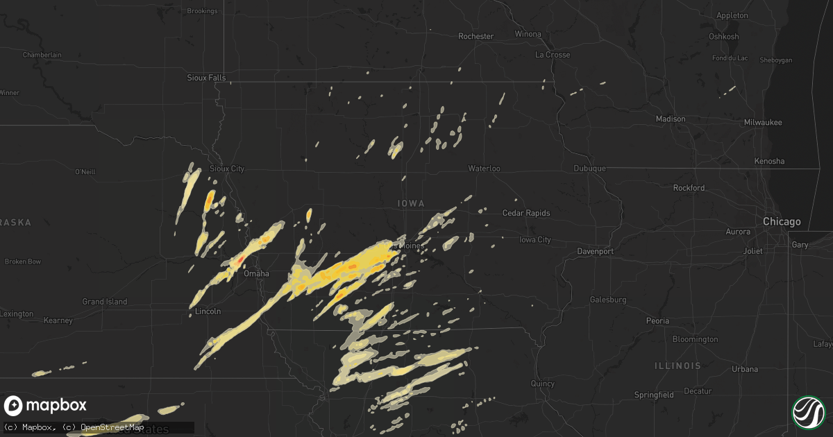
Hail Map in Iowa on March 22, 2011
Get this storm
March 22 map
$229
one time, instant access
Download today. No call, no setup
Keep the $229
Bought the map and want the full workflow? Apply the entire $229 to a subscription within 7 days. None of it is wasted.
Every map, not just this one
This buys you this map. Subscription and you get every map we run, in the markets you choose from a few cities to whole states to nationwide. Plus real-time alerts the moment a storm fires.
Contact data
Name, contact info, occupancy, even credit band for addresses in the footprint. You go from where it hit to who to call.
Become the source they trust
Unlimited branding weather history reports on demand. You already have the documented answer ready for the property owner, and you are the one who showed up with it.
Property data and RoofTrace estimates
Pull up any address you have got, its value and the exact code rules for that jurisdiction, straight from One Click Code. Then RoofTrace estimates the squares, pitch, and roof value, priced the way you price.
Storm reports in Iowa
Iowa
| Date | Description |
|---|---|
| 03/22/20116:59 PM CDT | A local report indicates 1.00 inch wind near 4 WNW ANKENY AIRPORT |
| 03/22/20116:49 PM CDT | A local report indicates 1.00 inch wind near WEST DES MOINES |
| 03/22/20116:46 PM CDT | Sheriff reported nickel to quarter size hail one mile south and one mile west of aredale. |
| 03/22/20116:44 PM CDT | At 144th st and aurora ave. |
| 03/22/20116:43 PM CDT | A local report indicates 1.75 inch wind near WINTERSET |
| 03/22/20116:37 PM CDT | Damage to a building. Roof blown off into the front yard. |
| 03/22/20116:36 PM CDT | A local report indicates 1.00 inch wind near 3 W WAUKEE |
| 03/22/20116:30 PM CDT | Vehicle damage reported. |
| 03/22/20116:28 PM CDT | Outbuilding debris and tree damage strewn over highway 169. Reported by off duty nws employee. |
| 03/22/20116:24 PM CDT | Damage to buildings. 20 inch diameter tree snapped off. |
| 03/22/20116:23 PM CDT | Tornado with property damage to an outbuilding. |
| 03/22/20116:19 PM CDT | Quarter hail |
| 03/22/20116:18 PM CDT | A local report indicates a tornado near 2 SW CRESTON |
| 03/22/20116:18 PM CDT | A local report indicates a tornado near 3 NE CRESTON |
| 03/22/20116:17 PM CDT | Tornado with debris. |
| 03/22/20116:17 PM CDT | A local report indicates a tornado near W CROMWELL |
| 03/22/20116:16 PM CDT | A local report indicates a tornado near 3 NE CRESTON AIRPORT |
| 03/22/20116:16 PM CDT | Debris observed |
| 03/22/20116:15 PM CDT | A local report indicates a tornado near 1 E CRESTON |
| 03/22/20116:15 PM CDT | Nws storm survey team rated this tornado an ef2 with peak winds of 120 mph. Continuous 11 mile path. Most damage was ef1 with one localized ef2 damage. Refer to the new |
| 03/22/20116:13 PM CDT | A local report indicates 1.50 inch wind near 2 S ORIENT |
| 03/22/20116:03 PM CDT | A local report indicates 1.75 inch wind near PRESCOTT |
| 03/22/20115:58 PM CDT | A local report indicates a tornado near 3 NW GREENFIELD |
| 03/22/20115:55 PM CDT | Wind damage to a machine shed from thunderstorm wind gusts. |
| 03/22/20115:50 PM CDT | A local report indicates 1.00 inch wind near 1 NE BRIDGEWATER |
| 03/22/20115:49 PM CDT | A local report indicates 1.75 inch wind near BRIDGEWATER |
| 03/22/20115:45 PM CDT | Tornado near delta ave and highway 92 ... |
| 03/22/20115:44 PM CDT | A local report indicates 1.75 inch wind near 6 W GREENFIELD |
| 03/22/20115:38 PM CDT | Kcin awos. |
| 03/22/20115:30 PM CDT | Nws storm survey team rated this tornado an ef1 with peak winds of 89 mph. Continuous 2 1/2 mile path. Most damage was ef0 with one localized ef1 damage. Refer to the n |
| 03/22/20115:23 PM CDT | Quarter to ping pong ball sized hail. |
| 03/22/20115:22 PM CDT | Shed blown down approximately 1 mile west of highway 92 and county road n28. Delayed report. Time approximate. |
| 03/22/20115:20 PM CDT | A local report indicates 1.00 inch wind near WOODBINE |
| 03/22/20115:13 PM CDT | Sustained winds of 45 to 50 mph. |
| 03/22/20115:08 PM CDT | A local report indicates 1.75 inch wind near 1 E ASPINWALL |
| 03/22/20115:05 PM CDT | 1 inch hail |
| 03/22/20115:04 PM CDT | A local report indicates 1.75 inch wind near 5 E MISSOURI VALLEY |
| 03/22/20115:04 PM CDT | A local report indicates 1.00 inch wind near 1 W RED OAK |
| 03/22/20115:03 PM CDT | Wall cloud spotted with storm. |
| 03/22/20115:00 PM CDT | A local report indicates a tornado near 2 E MISSOURI VALLEY |
| 03/22/20115:00 PM CDT | A local report indicates 1.75 inch wind near 1 N RED OAK |
| 03/22/20114:58 PM CDT | Delayed report from chaser website. |
| 03/22/20114:40 PM CDT | Nickel size hail also fell with the wind. |
| 03/21/201111:23 PM CDT | A local report indicates 60 MPH wind near 1 S MEDIAPOLIS |
| 03/21/201111:15 PM CDT | A local report indicates 58 MPH wind near DAVENPORT MUNICIPAL AIR |
| 03/21/201111:02 PM CDT | Delayed report from march 22nd. Idot rwis at i280/i80. |
| 03/21/20119:45 PM CDT | A local report indicates 60 MPH wind near E MORAVIA |
| 03/21/20117:50 PM CDT | A local report indicates 1.00 inch wind near BAXTER |
| 03/21/20117:48 PM CDT | A local report indicates 1.00 inch wind near DES MOINES INT AIRPORT |
| 03/21/20117:46 PM CDT | A local report indicates 1.00 inch wind near URBANDALE |
| 03/21/20117:41 PM CDT | Located on i-35 near mile marker 65. |
| 03/21/20117:26 PM CDT | Quarter to golf ball sized hail. |
| 03/21/20117:18 PM CDT | Location estimated |
| 03/21/20117:17 PM CDT | A local report indicates 1.00 inch wind near 6 S EARLHAM |
| 03/21/20117:14 PM CDT | Brief touchdown. |
| 03/21/20117:10 PM CDT | A local report indicates 1.00 inch wind near 3 WSW LENOX |
| 03/21/20117:08 PM CDT | Trained spotter estimated nickel to quarter size three miles southwest of charles city |
| 03/21/20117:07 PM CDT | Quarter sized hail covering the ground in dexter. |
| 03/21/20117:06 PM CDT | A local report indicates 1.00 inch wind near JOHNSTON |
| 03/21/20117:01 PM CDT | At 67th st and douglas ave. |
All States Impacted by Hail Map on March 22, 2011
Cities Impacted by Hail Map on March 22, 2011
- Dumont, IA
- Indianola, IA
- Saint Charles, IA
- Blue Earth, MN
- Mystic, IA
- Moravia, IA
- Centerville, IA
- Bancroft, IA
- New Albin, IA
- Eitzen, MN
- Adair, IA
- Anita, IA
- Pattonsburg, MO
- Valparaiso, NE
- Raymond, NE
- Marshalltown, IA
- Bevier, MO
- Excello, MO
- Callao, MO
- Villisca, IA
- Red Oak, IA
- Dixon, NE
- Stanton, NE
- Baxter, IA
- Melbourne, IA
- Newton, IA
- Cylinder, IA
- Ringsted, IA
- Ceresco, NE
- Forest City, IA
- Glen Elder, KS
- Beloit, KS
- Tipton, KS
- Runnells, IA
- Milan, MO
- Emerson, IA
- Elliott, IA
- Rayville, MO
- Lawson, MO
- Malvern, IA
- Glenwood, IA
- Tabor, IA
- Winterset, IA
- Garland, NE
- Pleasant Dale, NE
- Malcolm, NE
- Griswold, IA
- Dougherty, IA
- Sheffield, IA
- Rockwell, IA
- Galt, MO
- Kirksville, MO
- Humphreys, MO
- Green City, MO
- Greentop, MO
- Harris, MO
- Novinger, MO
- Green Castle, MO
- Pollock, MO
- Concord, NE
- Allen, NE
- Wakefield, NE
- Pilger, NE
- Wayne, NE
- King City, MO
- Woolstock, IA
- Clarion, IA
- Westside, IA
- Manning, IA
- Adams, MN
- Elkton, MN
- Omaha, NE
- Blair, NE
- Creston, IA
- Chillicothe, MO
- Fort Calhoun, NE
- Bennington, NE
- Washington, NE
- Kennard, NE
- Elkhorn, NE
- Valley, NE
- Ridgeway, IA
- Calmar, IA
- Cresco, IA
- Beatrice, NE
- Powersville, MO
- West Point, NE
- Walthill, NE
- Bedford, IA
- Burr, NE
- Dunbar, NE
- Nebraska City, NE
- Adams, NE
- Syracuse, NE
- Sterling, NE
- Denver, MO
- Traer, IA
- Toledo, IA
- Garwin, IA
- Thurman, IA
- Hastings, IA
- Henderson, IA
- Darlington, MO
- Albany, MO
- Stanberry, MO
- Promise City, IA
- Corydon, IA
- Bancroft, NE
- Winnebago, NE
- Thurston, NE
- Pender, NE
- Emerson, NE
- Glasco, KS
- Iron Ridge, WI
- Truro, IA
- Mount Ayr, IA
- Clearfield, IA
- Benton, IA
- Diagonal, IA
- Downs, KS
- Jamestown, KS
- Concordia, KS
- Osborne, KS
- Hamilton, MO
- Breckenridge, MO
- Mooresville, MO
- Arlington, NE
- Modale, IA
- Logan, IA
- Woodbine, IA
- Missouri Valley, IA
- Waterloo, NE
- Helena, MO
- Norwalk, IA
- Carlisle, IA
- Wheeling, MO
- Chula, MO
- Purdin, MO
- Linneus, MO
- Laredo, MO
- Winigan, MO
- Browning, MO
- Braymer, MO
- Carrollton, MO
- Bogard, MO
- Norborne, MO
- Keldron, SD
- Clyde, KS
- Clifton, KS
- Melrose, IA
- Martinsville, MO
- Worth, MO
- Gentry, MO
- Filley, NE
- Lake Mills, IA
- Dunlap, IA
- Van Meter, IA
- Cumming, IA
- Lamoni, IA
- Prescott, IA
- Corning, IA
- Hartford, WI
- Allenton, WI
- Mayville, WI
- Kellerton, IA
- Grand River, IA
- Decatur, IA
- Leon, IA
- Van Wert, IA
- Peru, IA
- Lorimor, IA
- Prole, IA
- Martensdale, IA
- Bevington, IA
- Killduff, IA
- Lynnville, IA
- Reasnor, IA
- Sully, IA
- Grinnell, IA
- Kellogg, IA
- Geneva, IA
- Aredale, IA
- Hampton, IA
- Beemer, NE
- Macon, MO
- Earlham, IA
- Linn, KS
- Palmer, KS
- Mercer, MO
- Eagle Grove, IA
- Ottumwa, IA
- Clifton Hill, MO
- Albert City, IA
- Fontanelle, IA
- Stuart, IA
- Massena, IA
- Bridgewater, IA
- Greenfield, IA
- Redding, IA
- Weldon, IA
- Alma, NE
- Hardy, IA
- Humboldt, IA
- Macedonia, IA
- Carson, IA
- Onawa, IA
- Dow City, IA
- Ithaca, NE
- Mead, NE
- Seward, NE
- Yutan, NE
- Ashland, NE
- Magnolia, IA
- Fremont, NE
- Earling, IA
- Wahoo, NE
- Haverhill, IA
- Williamsburg, IA
- Herman, NE
- Downing, MO
- Queen City, MO
- Lenox, IA
- Cumberland, IA
- Irwin, IA
- Cincinnati, IA
- Unionville, MO
- Sharpsburg, IA
- Gravity, IA
- Lucas, IA
- Woodburn, IA
- Belmond, IA
- Gallatin, MO
- Aspinwall, IA
- Manilla, IA
- Cook, NE
- Douglas, NE
- Otoe, NE
- Union, NE
- Pickrell, NE
- Rhodes, IA
- Maxwell, IA
- Mingo, IA
- Colfax, IA
- Laurel, IA
- Brooklyn, IA
- Malcom, IA
- Montezuma, IA
- Mitchellville, IA
- New Virginia, IA
- Osceola, IA
- Marble Rock, IA
- Greene, IA
- Ravenwood, MO
- Davis City, IA
- Garden Grove, IA
- Humeston, IA
- Allerton, IA
- Lineville, IA
- Republican City, NE
- Orleans, NE
- West Des Moines, IA
- Waukee, IA
- Macksburg, IA
- Urbandale, IA
- Dexter, IA
- Oakland, IA
- Pacific Junction, IA
- Adel, IA
- Lewis, IA
- Grant, IA
- Talmage, NE
- Hancock, IA
- Booneville, IA
- Clive, IA
- Orient, IA
- Menlo, IA
- De Soto, IA
- Latimer, IA
- Grant City, MO
- Rosalie, NE
- Afton, IA
- Murray, IA
- Thayer, IA
- Clare, IA
- Audubon, IA
- Stanton, IA
- Clarinda, IA
- Nodaway, IA
- Walnut, IA
- Redfield, IA
- Dallas Center, IA
- Cromwell, IA
- New Market, IA
- Trenton, MO
- Amity, MO
- Weatherby, MO
- McFall, MO
- Coffey, MO
- Rea, MO
- Savannah, MO
- Jameson, MO
- Bethany, MO
- New Hampton, MO
- Gilman City, MO
- Union Star, MO
- Jamesport, MO
- Maysville, MO
- Milo, IA
- Hooper, NE
- Linwood, NE
- Bruno, NE
- Wisner, NE
- Richmond, MO
- Palo, IA
- Shellsburg, IA
- Chapin, IA
- Rockford, IA
- Nora Springs, IA
- Salisbury, MO
- Dodge, NE
- Snyder, NE
- Scribner, NE
- North Bend, NE
- Larchwood, IA
- Tekamah, NE
- Laurel, NE
- Shannon City, IA
- Salem, IA
- Estherville, IA
- Princeton, MO
- Kingston, MO
- Polo, MO
- Drakesville, IA
- Charles City, IA
- Oakland, NE
- Uehling, NE
- Craig, NE
- Decatur, NE
- Clarence, MO
- Lyons, NE
- Atlantic, IA
- Jewell, IA
- Ellsworth, IA
- Williams, IA
- Storm Lake, IA
- Clarksville, IA
- Allison, IA
- Richland Center, WI
- Hillsboro, WI
- Ridgeway, MO
- Spickard, MO
- Fredericksburg, IA
- Lacona, IA
- Hardin, MO
- Firth, NE
- Cortland, NE
- Kimballton, IA
- Harlan, IA
- Avoca, IA
- Blakesburg, IA
- Shields, ND
- Natoma, KS
- Waldo, KS
- Alton, KS
- Winside, NE
- Altoona, IA
- Percival, IA
- Des Moines, IA
- Windsor Heights, IA
- Odell, NE
- Silver City, IA
- Grimes, IA
- Johnston, IA
- Ankeny, IA
- Casey, IA
- Imogene, IA
- Wiota, IA
- Unadilla, NE
- Nehawka, NE
- Diller, NE
- De Witt, NE
- Saint Joseph, MO
- Cosby, MO
- Monroe, IA
- Leigh, NE
- Palco, KS
- Saint Ansgar, IA
- Anabel, MO
- Milford, NE
- Newtown, MO
- Defiance, IA
- Patterson, IA
- Lansing, IA
- Pleasantville, IA
- Sheridan, MO
- Tingley, IA
- Eagleville, MO
- Guilford, MO
- Hatfield, MO
- Ellston, IA
- Blockton, IA
- Blythedale, MO
- Belle Plaine, IA
- Hartwick, IA
- Neosho, WI
- Hustisford, WI
- Huntsville, MO
- Bosworth, MO
- Hale, MO
- Moulton, IA
- Exline, IA
- Utica, MO
- Gilman, IA
- Cowgill, MO
- Armstrong, MO
- Albia, IA
- Soldiers Grove, WI
- Ludlow, MO
- Elmer, MO
- Bloomington, NE
- Dawn, MO
- Ames, NE
- North English, IA
- Deep River, IA
- Abie, NE
- David City, NE
- Kingdom City, MO
- Auxvasse, MO
- Lawler, IA
- New Hampton, IA
- Elberon, IA
- Simpson, KS
- Cainsville, MO
- Tina, MO
- Prairie City, IA
- Owatonna, MN
- Meadville, MO
- Buffalo Center, IA
- Bloomfield, IA
- Bladen, NE
- Little Sioux, IA
- Waterbury, NE
- Hubbard, NE
- Franklin, NE
- Chelsea, IA
- Vining, IA
- Oskaloosa, IA
- Klemme, IA
- Ferryville, WI
- Emden, IL
- Terra Alta, WV
- Eglon, WV
- Gormania, WV
- Oakland, MD
- Aurora, WV


