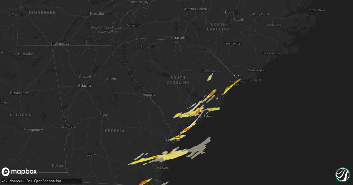
Hail Map in South Carolina on March 20, 2018
Get this storm
March 20 map
$229
one time, instant access
Download today. No call, no setup
Keep the $229
Bought the map and want the full workflow? Apply the entire $229 to a subscription within 7 days. None of it is wasted.
Every map, not just this one
This buys you this map. Subscription and you get every map we run, in the markets you choose from a few cities to whole states to nationwide. Plus real-time alerts the moment a storm fires.
Contact data
Name, contact info, occupancy, even credit band for addresses in the footprint. You go from where it hit to who to call.
Become the source they trust
Unlimited branding weather history reports on demand. You already have the documented answer ready for the property owner, and you are the one who showed up with it.
Property data and RoofTrace estimates
Pull up any address you have got, its value and the exact code rules for that jurisdiction, straight from One Click Code. Then RoofTrace estimates the squares, pitch, and roof value, priced the way you price.
Storm reports in South Carolina
South Carolina
| Date | Description |
|---|---|
| 03/20/20184:58 PM CDT | Berkeley co warning point reported quarter size hail at the dispatch center. Time estimted by radar. |
| 03/20/20184:40 PM CDT | Tree down at orangeburg rd in front of blackberry creek subdivision. Time estimated by radar. |
| 03/20/20182:55 PM CDT | Reported by andrews industrial supply on county line rd. |
| 03/20/20182:55 PM CDT | Reported by andrews industrial supply on county line rd. |
| 03/20/20182:39 PM CDT | A local report indicates 1.75 inch wind near 2 SW EDISTO ISLAND |
| 03/20/20182:34 PM CDT | Mping report of quarter size hail. |
| 03/20/20182:25 PM CDT | Two trees reported down near intersection of sc61 and arrowhead lane. Time estimated based on radar. |
| 03/20/20182:20 PM CDT | A local report indicates 1.75 inch wind near 3 S LADSON |
| 03/20/20182:18 PM CDT | A local report indicates 1.00 inch wind near 2 S LADSON |
| 03/20/20182:15 PM CDT | Berkeley warning point reported one inch hail. |
| 03/20/20182:12 PM CDT | Updated after measurement to indicate actual sizes averaged 1.5 inches with at least one hailstone measuring 1.75 inches. |
| 03/20/20182:12 PM CDT | Quarter-size hail reported on abbey lane within oakbrook subdivision. |
| 03/20/20182:10 PM CDT | Trained spotter reported golf ball size hail on st helena island near cuffee rd. |
| 03/20/20182:05 PM CDT | Largest hail identified was 1.75 inches...average size 1.0 inches. |
| 03/20/20182:00 PM CDT | Largest hail identified was 1.75 inches...average size 1.0 inches. |
| 03/20/20182:00 PM CDT | Photo of 2 inch hail measured on daufuskie island. |
| 03/20/20181:50 PM CDT | A local report indicates 1.00 inch wind near 1 WNW FOREST BEACH |
| 03/20/20181:45 PM CDT | Quarter size hail reported near central church on highway 278. |
| 03/20/201812:45 AM CDT | At 545 PM EDT, a severe thunderstorm was located near Summerville, moving east at 50 mph. HAZARD...60 mph wind gusts and quarter size hail. SOURCE...Radar indicated. IMPACT...Minor hail damage to vehicles is possible. Expect wind damage to trees and powerlines. Locations impacted include... Summerville, Moncks Corner, Ladson, Bonneau, Jamestown, Southern Lake Moultrie, Old Santee Canal State Park and Pinopolis.This warning includes I-26 between mile markers 191 and 200. |
| 03/20/201812:11 AM CDT | At 511 AM EDT, a severe thunderstorm was located 10 miles southwest of Magnolia Gardens, moving east at 60 mph. HAZARD...60 mph wind gusts and quarter size hail. SOURCE...Radar indicated. IMPACT...Minor hail damage to vehicles is possible. Expect wind damage to trees and powerlines. Locations impacted include... Charleston, North Charleston, Mount Pleasant, Downtown Charleston, Fort Sumter, Magnolia Gardens, I-26/I-526 Interchange and Hollywood.This warning includes... I-26 between mile markers 214 and 221. I-526 between mile markers 11 and 18, and between mile markers 23and 31. |
| 03/19/201811:26 PM CDT | At 425 AM EDT, severe thunderstorms were located along a line extending from 7 miles southwest of Walterboro to 10 miles southeast of Lake Warren State Park, moving east at 50 mph. HAZARD...60 mph wind gusts and penny size hail. SOURCE...Radar indicated. IMPACT...Expect damage to trees and powerlines. Locations impacted include... Walterboro, Yemassee, Hollywood, Ravenel, Meggett, Bennetts Point, Gardens Corner and Jacksonboro.This warning includes I-95 in South Carolina between mile markers 34and 57. |
| 03/19/201810:46 PM CDT | At 345 PM EDT, a severe thunderstorm was located near Trio, or 19 miles south of Kingstree, moving northeast at 25 mph. HAZARD...60 mph wind gusts and quarter size hail. SOURCE...Radar indicated. IMPACT...Minor hail damage to vehicles is possible. Expect wind damage to trees and power lines. Locations impacted include... Andrews, Rhems, Trio, Warsaw, Earle, Nesmith, Morrisville, Henry and Oatland. |
| 03/19/201810:18 PM CDT | At 318 PM EDT, a severe thunderstorm was located 10 miles southeast of Walterboro, moving east at 45 mph. HAZARD...60 mph wind gusts and half dollar size hail. SOURCE...Radar indicated. IMPACT...Minor hail damage to vehicles is possible. Expect wind damage to trees and powerlines. Locations impacted include... Charleston, Edisto Beach, Hollywood, Folly Beach, Ravenel, Seabrook Island, Kiawah Island and Meggett. |
| 03/19/201810:08 PM CDT | At 306 AM EDT, a severe thunderstorm was nearing the Alexander area and moving east near 45 mph and toward the Girard and Sardis areas. HAZARD...70 mph wind gusts. SOURCE...Radar indicated. IMPACT...Expect considerable tree damage. Damage is likely to mobile homes, roofs, and outbuildings. Locations impacted include... Sardis and Girard. |
| 03/19/201810:06 PM CDT | At 306 PM EDT, severe thunderstorms were located along a line extending from 7 miles southeast of Moncks Corner to near Slands Bridge, moving northeast at 45 mph. HAZARD...60 mph wind gusts and quarter size hail. SOURCE...Radar indicated. IMPACT...Minor hail damage to vehicles is possible. Expect wind damage to trees and powerlines. Locations impacted include... Charleston, North Charleston, Summerville, Goose Creek, Hanahan, Moncks Corner, Middleton Place and Slands Bridge.This warning includes... I-26 between mile markers 188 and 220. I-526 between mile markers 11 and 26. |
| 03/19/20189:52 PM CDT | At 252 PM EDT, a severe thunderstorm was located 11 miles north of Yemassee, moving east at 40 mph. HAZARD...60 mph wind gusts and half dollar size hail. SOURCE...Radar indicated. IMPACT...Minor hail damage to vehicles is possible. Expect wind damage to trees and powerlines. Locations impacted include... Walterboro, Cottageville, Hendersonville and Round O. This warning includes I-95 in South Carolina between mile markers 44and 63. |
| 03/19/20189:28 PM CDT | At 228 PM EDT, a severe thunderstorm was located over Savannah, moving northeast at 55 mph. HAZARD...60 mph wind gusts and quarter size hail. SOURCE...Radar indicated. IMPACT...Minor hail damage to vehicles is possible. Expect wind damage to trees and powerlines. Locations impacted include... Savannah, Hilton Head Island, Bluffton, Beaufort, Port Royal, Wilmington Island, Fort Pulaski National Monument and Bellinger Hill Area.This warning includes... I-16 between mile markers 164 and 168. I-516 between mile markers 4 and 9. |
| 03/19/20188:56 PM CDT | At 154 AM EDT, a likely severe thunderstorm in southern McDuffie County was moving eastward near 45 mph and toward Richmond County and northern Burke County. HAZARD...60 mph wind gusts. SOURCE...Radar indicated. IMPACT...Expect damage to roofs, siding, and trees. Locations impacted include... Grovetown, Evans, Augusta, Martinez, Fort Gordon, Hephzibah, Blythe and Keysville. |
| 03/19/20188:55 PM CDT | Hail reported at bojangles restaurant on highway 9. |
| 03/19/20188:30 PM CDT | In target parking lot... Small hail covered ground... Mixed with several stones as large as quarters. |
| 03/19/20188:22 PM CDT | Report received from wbtw... Hail fell in the parking lot of the station. |
| 03/19/20188:21 PM CDT | Report relayed by wfo charleston sc |
All States Impacted by Hail Map on March 20, 2018
Cities Impacted by Hail Map on March 20, 2018
- Deland, FL
- Dunnellon, FL
- Beverly Hills, FL
- Groveland, FL
- Mascotte, FL
- Orlando, FL
- Windermere, FL
- Winter Garden, FL
- Green Pond, SC
- Edisto Island, SC
- Saint Helena Island, SC
- Jacksonville, FL
- Oviedo, FL
- Winter Park, FL
- Chiefland, FL
- Summerville, SC
- Savannah, GA
- Hilton Head Island, SC
- Bluffton, SC
- Daufuskie Island, SC
- Daytona Beach, FL
- Ormond Beach, FL
- Millwood, GA
- Hortense, GA
- Waycross, GA
- Brunswick, GA
- Townsend, GA
- Patterson, GA
- Darien, GA
- Riceboro, GA
- Midway, GA
- Nicholls, GA
- Sapelo Island, GA
- Bristol, GA
- Mershon, GA
- Axson, GA
- Jesup, GA
- Screven, GA
- Blackshear, GA
- Ocoee, FL
- Gotha, FL
- Old Town, FL
- Andrews, SC
- Wauchula, FL
- Bowling Green, FL
- Parrish, FL
- Surrency, GA
- Odum, GA
- Myrtle Beach, SC
- Atlantic Beach, FL
- Neptune Beach, FL
- Lorida, FL
- Okeechobee, FL
- Zolfo Springs, FL
- Sebring, FL
- Myakka City, FL
- Ona, FL
- Avon Park, FL
- Edgemoor, SC
- Goose Creek, SC
- De Leon Springs, FL
- Paisley, FL
- Ridgeville, SC
- Ocala, FL
- Murrells Inlet, SC
- Georgetown, SC
- Vero Beach, FL
- Fernandina Beach, FL
- Cottageville, SC
- Adams Run, SC
- North Charleston, SC
- Charleston, SC
- Ladson, SC
- Eustis, FL
- Umatilla, FL
- Altoona, FL
- Macclenny, FL
- Bryceville, FL
- Lake City, FL
- Lulu, FL
- Glen Saint Mary, FL
- Little River, SC
- North Myrtle Beach, SC
- Longs, SC
- Silver Springs, FL
- Ocklawaha, FL
- Merritt Island, FL
- Christmas, FL
- Cocoa, FL
- Titusville, FL
- Patrick Afb, FL
- Cape Canaveral, FL
- Moncks Corner, SC
- Beaufort, SC
- Wadmalaw Island, SC
- Apopka, FL
- Clermont, FL
- Saint George, GA
- Folkston, GA
- Hilliard, FL
- Round O, SC
- Pinopolis, SC
- Lake Butler, FL
- Fort White, FL
- Sanderson, FL
- Trenton, FL
- Newberry, FL
- McClellanville, SC
- Awendaw, SC
- Varnville, SC
- Walterboro, SC
- Ruffin, SC
- Early Branch, SC
- Branford, FL
- Mims, FL
- Scranton, SC
- Coward, SC
- Terra Ceia, FL
- Palmetto, FL
- Mount Pleasant, SC
- Yemassee, SC
- Oakland, FL
- Maitland, FL
- Nesmith, SC
- Kingstree, SC
- Saint Stephen, SC
- Lane, SC
- Bonneau, SC
- Baxley, GA
- Alma, GA
- Pierson, FL
- Dorchester, SC
- Saint Augustine, FL
- Lake City, SC
- Effingham, SC
- Pamplico, SC
- Nakina, NC
- Fort Pierce, FL
- Ravenel, SC
- Loris, SC
- Tabor City, NC
- Huger, SC
- Cordesville, SC
- Hollywood, SC
- Hanahan, SC
- Johns Island, SC
- Bushnell, FL
- Cross City, FL
- Fort McCoy, FL
- Webster, FL
- Florence, SC
- Spring Hill, FL
- Crystal River, FL
- Homosassa, FL
- Lecanto, FL
- Satsuma, FL
- Monroe, NC
- Starke, FL
- Brooksville, FL
- Jamestown, SC
- Horseshoe Beach, FL
- Winter Springs, FL
- Casselberry, FL
- Yulee, FL
- Islandton, SC
- Ash, NC
- Calabash, NC
- Conway, SC


