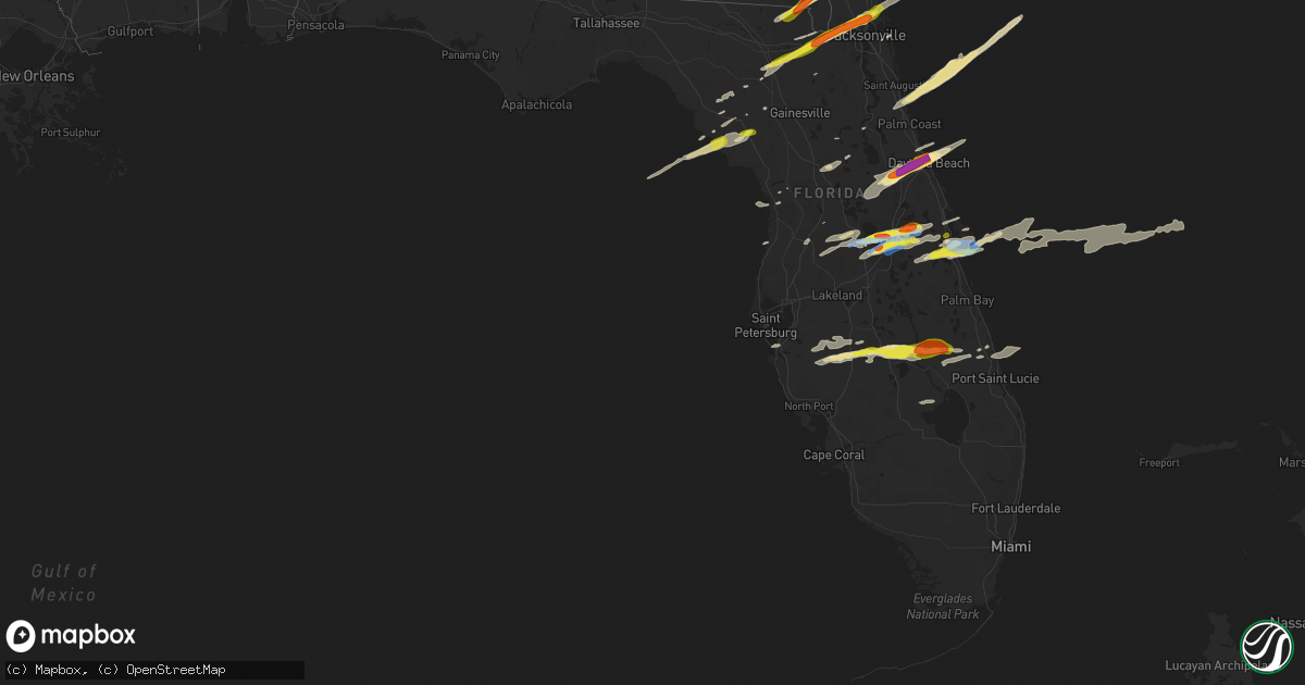
Hail Map in Florida on March 20, 2018
Get this storm
March 20 map
$229
one time, instant access
Download today. No call, no setup
Keep the $229
Bought the map and want the full workflow? Apply the entire $229 to a subscription within 7 days. None of it is wasted.
Every map, not just this one
This buys you this map. Subscription and you get every map we run, in the markets you choose from a few cities to whole states to nationwide. Plus real-time alerts the moment a storm fires.
Contact data
Name, contact info, occupancy, even credit band for addresses in the footprint. You go from where it hit to who to call.
Become the source they trust
Unlimited branding weather history reports on demand. You already have the documented answer ready for the property owner, and you are the one who showed up with it.
Property data and RoofTrace estimates
Pull up any address you have got, its value and the exact code rules for that jurisdiction, straight from One Click Code. Then RoofTrace estimates the squares, pitch, and roof value, priced the way you price.
Storm reports in Florida
Florida
| Date | Description |
|---|---|
| 03/20/20185:10 PM CDT | Quarter size hail near fort drum from storm chaser. Time estimated by radar. |
| 03/20/20184:51 PM CDT | A trained spotter reports 2 inch hail in holly hill. |
| 03/20/20184:51 PM CDT | Trained spotter reports 2 inch hail in daytona beach. |
| 03/20/20184:50 PM CDT | Numerous reports of hail one inch or slightly larger near intersection of jimmy ann dr and lpga blvd. |
| 03/20/20184:50 PM CDT | A large amount of quarter to half dollar sized hail fell at 530 ruth street in daytona beach. |
| 03/20/20184:50 PM CDT | Hail from nickel to quarter size reported by the daytona beach news journal office on 6th st in daytona beach. |
| 03/20/20184:50 PM CDT | Penny to quarter size hail. |
| 03/20/20184:50 PM CDT | Near intersection of seabreeze blvd and halifax ave in daytona beach. |
| 03/20/20184:35 PM CDT | Awos at sebring regional airport reported a wind gust of 62 mph. |
| 03/20/20184:35 PM CDT | A member of the public reported golf ball sized hail just north of deleon springs. He reported damage to his pool screen enclosure. |
| 03/20/20184:30 PM CDT | Widespread trees and power lines down throughout highlands county. |
| 03/20/20184:23 PM CDT | Quarter size hail in ormond beach. Time estimated by radar. |
| 03/20/20184:15 PM CDT | Highlands county em reported an overturned produce truck on sr 621 and charlie dr. |
| 03/20/20184:15 PM CDT | Highlands county em reported a downed tree on lakeview dr. In sebring. |
| 03/20/20183:45 PM CDT | Numerous large tree branches snapped and fences downed. |
| 03/20/20183:14 PM CDT | Hail up to half dollar size north merritt island. |
| 03/20/20183:06 PM CDT | Report from usaf meteorologist... Along tangelo ave about 1/4 mile east of i-95 in canaveral groves. |
| 03/20/20183:02 PM CDT | Delayed report - a trained spotter measured a 65mph wind gust at a weather station in north merritt island. |
| 03/20/20183:00 PM CDT | Usaf wind tower 403 had gust to 62 knots from nw. |
| 03/20/20182:56 PM CDT | The awos at the ccafs skid strip measured a peak wind gust of 63 knots / 73 mph from the west. |
| 03/20/20182:55 PM CDT | Usaf wind tower gust of 50 knots from nw. |
| 03/20/20182:54 PM CDT | Quarter size hail. |
| 03/20/20182:30 PM CDT | Quarter size hail near alafaya trail and stoney brook east. |
| 03/20/20182:30 PM CDT | Widespread ping pong sized hail fell over the jacksonville nws wfo with largest stones at golf ball sized. Size measured and verified by nws employees. |
| 03/20/20182:25 PM CDT | Widespread quarter sized hail about 12 miles south of jacksonville. |
| 03/20/20182:25 PM CDT | Widespread quarter sized hail. |
| 03/20/20182:22 PM CDT | Ping pong sized hail observed near hilliard in nassau county. |
| 03/20/20182:22 PM CDT | Quarter size hail near intersection of hoffner/semoran just north of oia. |
| 03/20/20182:18 PM CDT | Widespread hail up to ping pong ball sized observed at bryceville. |
| 03/20/20182:17 PM CDT | Hail reported as quarter size or larger near intersection of gatlin and conway. |
| 03/20/20182:15 PM CDT | A trained spotter reported 1.25 inch or half dollar sized hail 3 miles north of orlando international airport. |
| 03/20/20182:15 PM CDT | Delayed report - an emergency management official reported hail the size of golf balls in ocoee. |
| 03/20/20182:14 PM CDT | Trained spotter reported quarter sized hail at the 4300 block of john young parkway. |
| 03/20/20182:10 PM CDT | Public report via facebook of two palm trees snapped and small hail in the shore acres area. |
| 03/20/20182:06 PM CDT | Widespread hail up to 1 inch observed near macclenney. |
| 03/20/20182:03 PM CDT | Quarter size hail in maitland... Relayed by em. |
| 03/20/20181:59 PM CDT | Delayed report- per social media search... Various members of the public report hail ranging from ping pong ball to golf ball size fell in an area from oviedo to chuluo |
| 03/20/20181:59 PM CDT | Trained spotter reported quarter sized hail near ucf. |
| 03/20/20181:57 PM CDT | A local report indicates 1.50 inch wind near 5 WSW CHULUOTA |
| 03/20/20181:40 PM CDT | A local report indicates 1.00 inch wind near 4 S ALTAMONTE SPRINGS |
| 03/20/20181:33 PM CDT | Golf ball size hail in pine hills. Time estimated from radar. |
| 03/20/20181:32 PM CDT | Hail up to quarter size in pine hills area. |
| 03/20/201812:25 PM CDT | Levy county public works reported half dollar size hail in chiefland. Also received a report of quarter size hail from a trained spotter in chiefland. |
| 03/20/201812:11 PM CDT | Estimated quarter size hail from the yellow jacket rv park. |
| 03/20/20187:53 AM CDT | At 1252 PM EDT, a severe thunderstorm was located 5 miles southeast of Horseshoe Point, or 20 miles south of Cross City, moving east at 60 mph. HAZARD...60 mph wind gusts and quarter size hail. SOURCE...Radar indicated. IMPACT...Hail damage to vehicles is expected. Expect wind damage to roofs, siding, and trees. Locations impacted include... Chiefland, Fowlers Bluff, Andrews, Manattee Road, Fanning Springs, Otter Creek and Manatee Springs State Park. |
| 03/20/20187:48 AM CDT | At 1248 PM EDT, a severe thunderstorm was located 7 miles south of Horseshoe Point, or 23 miles southwest of Cross City, moving east at 60 mph. HAZARD...60 mph wind gusts and quarter size hail. SOURCE...Radar indicated. IMPACT...Hail damage to vehicles is expected. Expect wind damage to roofs, siding, and trees. Locations impacted include... Horseshoe Point, Fowlers Bluff, Suwannee, Horseshoe Beach, Shired Island, Old Town, Yellow Jacket and Fanning Springs. |
| 03/20/20185:31 AM CDT | At 1030 AM EDT, a severe thunderstorm was located just west Ormond Beach, moving east at 35 mph. HAZARD...60 mph wind gusts. SOURCE...Radar indicated. IMPACT...Expect damage to roofs, siding, and trees. Locations impacted include... Daytona Beach, Ormond Beach, Holly Hill, Ormond-By-the-Sea and Ormond Beach Airport. |
| 03/20/20184:30 AM CDT | At 928 AM EDT, a severe thunderstorm was located over DeLeon Springs, moving east at 40 mph. HAZARD...60 mph wind gusts. SOURCE...Radar indicated. IMPACT...Expect damage to roofs, siding, and trees. Locations impacted include... DeLeon Springs, Daytona Beach, Port Orange, DeLand, South Daytona and Holly Hill. |
| 03/20/20183:22 AM CDT | At 821 PM EDT, a severe thunderstorm was located near Belle Meade, or near Marco Island, moving east at 50 mph. HAZARD...60 mph wind gusts and penny size hail. SOURCE...Radar indicated. IMPACT...Expect damage to roofs, siding, and trees. Locations impacted include... Marco Island, Carnestown, Marco Island Airport, Belle Meade and Naples Manor. |
| 03/20/20183:13 AM CDT | At 813 PM EDT, a severe thunderstorm was located 7 miles west of Jonathan Dickinson State Park, or 7 miles southwest of Hobe Sound, moving east at 55 mph. HAZARD...60 mph wind gusts and quarter size hail. SOURCE...Radar indicated. IMPACT...Hail damage to vehicles is expected. Expect wind damage to roofs, siding, and trees. Locations impacted include... Tequesta, Jupiter Island, Hobe Sound, Hobe Sound Beach and Jonathan Dickinson State Park. |
| 03/20/20182:51 AM CDT | At 751 PM EDT, a severe thunderstorm was located near Canal Point, moving east at 50 mph. HAZARD...60 mph wind gusts and nickel size hail. SOURCE...Radar indicated. IMPACT...Expect damage to roofs, siding, and trees. Locations impacted include... Pahokee and Canal Point. |
| 03/20/20181:21 AM CDT | At 621 PM EDT, a severe thunderstorm was located 10 miles northeast of Babcock Ranch, or 13 miles southeast of Arcadia, moving east at 40 mph. HAZARD...60 mph wind gusts and nickel size hail. SOURCE...Radar indicated. IMPACT...Expect damage to roofs, siding, and trees. Locations impacted include... Lake Placid, Venus, Archbold and Placid Lakes. |
| 03/20/201812:56 AM CDT | At 555 PM EDT, a severe thunderstorm was located near Kissimmee Prarie Preserve, or 9 miles west of Fort Drum, moving east at 45 mph. HAZARD...60 mph wind gusts and half dollar size hail. SOURCE...Radar indicated. IMPACT...Hail damage to vehicles is expected. Expect wind damage to roofs, siding, and trees. Locations impacted include... Fort Drum, Kissimmee Prarie Preserve, as well as rural portions of far southwestern Indian River County and far northwestern Saint Lucie County. |
| 03/20/201812:32 AM CDT | At 532 PM EDT, a severe thunderstorm was located over DeLand Airport, or near DeLeon Springs, moving northeast at 55 mph. HAZARD...70 mph wind gusts and half dollar size hail. SOURCE...Radar indicated. IMPACT...Hail damage to vehicles is expected. Expect considerable tree damage. Wind damage is also likely to mobile homes, roofs, and outbuildings. Locations impacted include... Daytona Beach, Port Orange, Ormond Beach, DeLand and South Daytona. |
| 03/19/201811:56 PM CDT | At 455 PM EDT, a severe thunderstorm was located 8 miles east of Wauchula, moving east at 40 mph. HAZARD...60 mph wind gusts and quarter size hail. SOURCE...Radar indicated. IMPACT...Hail damage to vehicles is expected. Expect wind damage to roofs, siding, and trees. Locations impacted include... Sebring, Avon Park, Avon Park Air Force Range, Sebring Shores and Avon Park Executive Airport. |
| 03/19/201811:40 PM CDT | At 440 PM EDT, a severe thunderstorm was located 9 miles southeast of Hastings, moving northeast at 60 mph. HAZARD...60 mph wind gusts and quarter size hail. SOURCE...Radar indicated. IMPACT...Hail damage to vehicles is expected. Expect wind damage to roofs, siding, and trees. Locations impacted include... Palm Coast, Flagler Beach, Bunnell, Hastings, Andalusia, Saint Augustine Beach, Marineland, Crescent Beach, Saint Augustine Shores and Butler Beach. |
| 03/19/201811:37 PM CDT | At 436 PM EDT, a severe thunderstorm was located near Ona, or near Wauchula, moving east at 75 mph. HAZARD...60 mph wind gusts and quarter size hail. SOURCE...Radar indicated. IMPACT...Hail damage to vehicles is expected. Expect wind damage to roofs, siding, and trees. Locations impacted include... Sebring, Avon Park, Wauchula, Ona, Zolfo Springs, Avon Park Executive Airport, Avon Park Air Force Range and Sebring Shores. |
| 03/19/201810:54 PM CDT | At 353 PM EDT, a severe thunderstorm was located near Anna Maria, or near Bradenton, moving east at 40 mph. HAZARD...70 mph wind gusts and nickel size hail. SOURCE...Radar indicated. IMPACT...Expect considerable tree damage. Damage is likely to mobile homes, roofs, and outbuildings. Locations impacted include... Sarasota, Bradenton, Palmetto, Anna Maria, Lakewood Ranch, Ellenton, North Sarasota, Memphis, Sarasota Bradenton Airport, West Samoset, The Meadows, South Bradenton, Parrish, West Bradenton, Kensington Park, Holmes Beach, Bradenton Beach, Lake Manatee State Park, Samoset and Desoto Lakes. |
| 03/19/201810:42 PM CDT | At 341 PM EDT, a severe thunderstorm was located near Titusville Airport, moving east at 45 mph. HAZARD...60 mph wind gusts and quarter size hail. SOURCE...Radar indicated. IMPACT...Hail damage to vehicles is expected. Expect wind damage to roofs, siding, and trees. Locations impacted include... Titusville, Rockledge, Cocoa, Cocoa Beach and Cape Canaveral. |
| 03/19/201810:18 PM CDT | At 317 PM EDT, a severe thunderstorm was located over Azalea Park, moving northeast at 50 mph. Quarter sized hail has already been reported with this storm. HAZARD...Ping pong ball size hail and 60 mph wind gusts. SOURCE...Radar indicated. IMPACT...People and animals outdoors will be injured. Expect hail damage to roofs, siding, windows, and vehicles. Expect wind damage to roofs, siding, and trees. Locations impacted include... Orlando, Winter Park, Wedgefield, Avalon Park and Orlando International Airport. |
| 03/19/201810:14 PM CDT | At 314 PM EDT, severe thunderstorms were located along a line extending from near Gandy to near Memphis, moving east at 45 mph. HAZARD...60 mph wind gusts and nickel size hail. SOURCE...Radar indicated. IMPACT...Expect damage to roofs, siding, and trees. Locations impacted include... Tampa, Bradenton, Pinellas Park, Palmetto, Fish Hawk, Downtown Saint Petersburg, Saint Petersburg, Fort Desoto Park, Brandon, St. Petersburg, St. Pete Beach, Anna Maria, Tierra Verde, Greater Sun Center, Palm River-Clair Mel, Memphis, West Samoset, Riverview, West And East Lealman and Parrish. |
| 03/19/201810:09 PM CDT | At 308 PM EDT, severe thunderstorms were located along a line extending from St. Pete Beach to near Anna Maria, moving northeast at 45 mph. HAZARD...60 mph wind gusts and nickel size hail. SOURCE...Radar indicated. IMPACT...Expect damage to roofs, siding, and trees. Locations impacted include... Fort Desoto Park, St. Petersburg, St. Pete Beach, Anna Maria, Tierra Verde, Holmes Beach and Pass-A-Grille Beach. |
| 03/19/201810:03 PM CDT | At 302 PM EDT, a severe thunderstorm was located over Bay Hill, or near Windermere, moving northeast at 50 mph. HAZARD...60 mph wind gusts and half dollar size hail. SOURCE...Radar indicated. IMPACT...Hail damage to vehicles is expected. Expect wind damage to roofs, siding, and trees. Locations impacted include... Orlando, Windermere, Bay Lake, Oak Ridge and Conway. |
| 03/19/20189:48 PM CDT | At 248 PM EDT, a severe thunderstorm was located over Goldenrod, moving east at 40 mph. HAZARD...70 mph wind gusts and half dollar size hail. SOURCE...Radar indicated. IMPACT...Hail damage to vehicles is expected. Expect considerable tree damage. Wind damage is also likely to mobile homes, roofs, and outbuildings. Locations impacted include... Orlando, Oviedo, Winter Springs, Winter Park, University of Central Florida, and Casselberry. |
| 03/19/20189:24 PM CDT | At 224 PM EDT, a severe thunderstorm was located over Mascotte, moving northeast at 45 mph. HAZARD...60 mph wind gusts and quarter size hail. SOURCE...Radar indicated. IMPACT...Hail damage to vehicles is expected. Expect wind damage to roofs, siding, and trees. Locations impacted include... Groveland, Mascotte, Howey-In-the-hills, Ferndale and Clermont. |
| 03/19/20189:23 PM CDT | At 223 PM EDT, severe thunderstorms were located along a line extending from 8 miles north of Bell to near Manattee Road, moving northeast at 55 mph. HAZARD...Ping pong ball size hail and 60 mph wind gusts. SOURCE...Radar indicated. IMPACT...People and animals outdoors will be injured. Expect hail damage to roofs, siding, windows, and vehicles. Expect wind damage to roofs, siding, and trees. Locations impacted include... Gainesville, Starke, Trenton, Lake Butler, Bell, Raiford, Worthington Spring, Ichetucknee Spring, Columbia and Alachua. |
| 03/19/20189:21 PM CDT | At 221 PM EDT, a severe thunderstorm was located 8 miles southwest of Ichetucknee Spring, moving east at 70 mph. HAZARD...60 mph wind gusts and quarter size hail. SOURCE...Radar indicated. IMPACT...Hail damage to vehicles is expected. Expect wind damage to roofs, siding, and trees. Locations impacted include... Hatch Bend and Fletcher Springs. |
| 03/19/20189:04 PM CDT | At 202 PM EDT, multiple severe thunderstorms was located in Hernando and Pasco counties moving northeast at 55 mph. HAZARD...60 mph wind gusts and quarter size hail. SOURCE...Radar indicated. IMPACT...Hail damage to vehicles is expected. Expect wind damage to roofs, siding, and trees. Locations impacted include... Spring Hill, Brooksville, Wildwood, Dade City, Bushnell, Hill n Dale, South Brooksville, North Brooksville, Hernando County Airport, North Weeki Wachee, Lake Panasoffkee, Ridge Manor, Center Hill, Webster, Coleman, High Point, Lake Lindsey, Adamsville, Glen Lakes and Sumterville. |
| 03/19/20188:51 PM CDT | At 151 PM EDT, a severe thunderstorm was located over Alachua, or 12 miles southwest of Worthington Spring, moving northeast at 55 mph. HAZARD...60 mph wind gusts and quarter size hail. SOURCE...Radar indicated. IMPACT...Hail damage to vehicles is expected. Expect wind damage to roofs, siding, and trees. Locations impacted include... Starke, Worthington Spring, Alachua, High Springs, Worthington Springs, Beasley, New River, Sampson, Lawtey and Hampton. |
| 03/19/20188:39 PM CDT | At 137 PM EDT, a severe thunderstorm was located 11 miles southwest of Mascotte, moving east at 45 mph. HAZARD...60 mph wind gusts and quarter size hail. SOURCE...Radar indicated. IMPACT...Hail damage to vehicles is expected. Expect wind damage to roofs, siding, and trees. Locations impacted include... Groveland, Mascotte, Ferndale, Clermont and Lake Louisa. |
| 03/19/20188:35 PM CDT | At 135 PM EDT, a severe thunderstorm was located 10 miles northeast of Dade City, moving east at 40 mph. HAZARD...60 mph wind gusts and quarter size hail. SOURCE...Radar indicated. IMPACT...Hail damage to vehicles is expected. Expect wind damage to roofs, siding, and trees. This severe thunderstorm will remain over mainly rural areas of southeastern Sumter and eastern Pasco Counties. |
| 03/19/20188:29 PM CDT | At 129 PM EDT, a severe thunderstorm was located near Chiefland, moving east at 50 mph. HAZARD...60 mph wind gusts and half dollar size hail. SOURCE...Radar indicated. IMPACT...Hail damage to vehicles is expected. Expect wind damage to roofs, siding, and trees. Locations impacted include... Gainesville, Trenton, Citra, Alachua, Hawthorne, Archer, University Of Florida, Rochelle, Cross Creek and Orange Heights. |
| 03/19/20188:26 PM CDT | At 126 PM EDT, a severe thunderstorm was located 7 miles northeast of Beverly Hills, moving east at 50 mph. HAZARD...60 mph wind gusts and quarter size hail. SOURCE...Radar indicated. IMPACT...Hail damage to vehicles is expected. Expect wind damage to roofs, siding, and trees. Locations impacted include... Ocala, Salt Springs, Juniper Springs, Lynne, Weirsdale, Ocklawaha, Moss Bluff, Silver Springs Shores, Lake Weir and Santos. |
| 03/19/20188:20 PM CDT | At 120 PM EDT, a severe thunderstorm was located over Kingsley, or near Starke, moving northeast at 50 mph. HAZARD...60 mph wind gusts and penny size hail. SOURCE...Radar indicated. IMPACT...Expect damage to roofs, siding, and trees. Locations impacted include... Jacksonville, Orange Park, Green Cove Springs, Starke, Unf, Mandarin, Fruit Cove, Arlington, Middleburg and Ponte Vedra Beach. |
All States Impacted by Hail Map on March 20, 2018
Cities Impacted by Hail Map on March 20, 2018
- Deland, FL
- Dunnellon, FL
- Beverly Hills, FL
- Groveland, FL
- Mascotte, FL
- Orlando, FL
- Windermere, FL
- Winter Garden, FL
- Green Pond, SC
- Edisto Island, SC
- Saint Helena Island, SC
- Jacksonville, FL
- Oviedo, FL
- Winter Park, FL
- Chiefland, FL
- Summerville, SC
- Savannah, GA
- Hilton Head Island, SC
- Bluffton, SC
- Daufuskie Island, SC
- Daytona Beach, FL
- Ormond Beach, FL
- Millwood, GA
- Hortense, GA
- Waycross, GA
- Brunswick, GA
- Townsend, GA
- Patterson, GA
- Darien, GA
- Riceboro, GA
- Midway, GA
- Nicholls, GA
- Sapelo Island, GA
- Bristol, GA
- Mershon, GA
- Axson, GA
- Jesup, GA
- Screven, GA
- Blackshear, GA
- Ocoee, FL
- Gotha, FL
- Old Town, FL
- Andrews, SC
- Wauchula, FL
- Bowling Green, FL
- Parrish, FL
- Surrency, GA
- Odum, GA
- Myrtle Beach, SC
- Atlantic Beach, FL
- Neptune Beach, FL
- Lorida, FL
- Okeechobee, FL
- Zolfo Springs, FL
- Sebring, FL
- Myakka City, FL
- Ona, FL
- Avon Park, FL
- Edgemoor, SC
- Goose Creek, SC
- De Leon Springs, FL
- Paisley, FL
- Ridgeville, SC
- Ocala, FL
- Murrells Inlet, SC
- Georgetown, SC
- Vero Beach, FL
- Fernandina Beach, FL
- Cottageville, SC
- Adams Run, SC
- North Charleston, SC
- Charleston, SC
- Ladson, SC
- Eustis, FL
- Umatilla, FL
- Altoona, FL
- Macclenny, FL
- Bryceville, FL
- Lake City, FL
- Lulu, FL
- Glen Saint Mary, FL
- Little River, SC
- North Myrtle Beach, SC
- Longs, SC
- Silver Springs, FL
- Ocklawaha, FL
- Merritt Island, FL
- Christmas, FL
- Cocoa, FL
- Titusville, FL
- Patrick Afb, FL
- Cape Canaveral, FL
- Moncks Corner, SC
- Beaufort, SC
- Wadmalaw Island, SC
- Apopka, FL
- Clermont, FL
- Saint George, GA
- Folkston, GA
- Hilliard, FL
- Round O, SC
- Pinopolis, SC
- Lake Butler, FL
- Fort White, FL
- Sanderson, FL
- Trenton, FL
- Newberry, FL
- McClellanville, SC
- Awendaw, SC
- Varnville, SC
- Walterboro, SC
- Ruffin, SC
- Early Branch, SC
- Branford, FL
- Mims, FL
- Scranton, SC
- Coward, SC
- Terra Ceia, FL
- Palmetto, FL
- Mount Pleasant, SC
- Yemassee, SC
- Oakland, FL
- Maitland, FL
- Nesmith, SC
- Kingstree, SC
- Saint Stephen, SC
- Lane, SC
- Bonneau, SC
- Baxley, GA
- Alma, GA
- Pierson, FL
- Dorchester, SC
- Saint Augustine, FL
- Lake City, SC
- Effingham, SC
- Pamplico, SC
- Nakina, NC
- Fort Pierce, FL
- Ravenel, SC
- Loris, SC
- Tabor City, NC
- Huger, SC
- Cordesville, SC
- Hollywood, SC
- Hanahan, SC
- Johns Island, SC
- Bushnell, FL
- Cross City, FL
- Fort McCoy, FL
- Webster, FL
- Florence, SC
- Spring Hill, FL
- Crystal River, FL
- Homosassa, FL
- Lecanto, FL
- Satsuma, FL
- Monroe, NC
- Starke, FL
- Brooksville, FL
- Jamestown, SC
- Horseshoe Beach, FL
- Winter Springs, FL
- Casselberry, FL
- Yulee, FL
- Islandton, SC
- Ash, NC
- Calabash, NC
- Conway, SC


