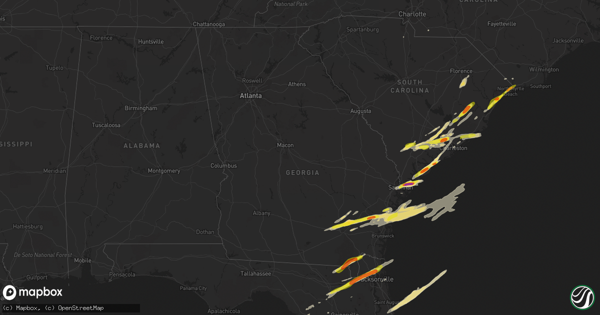
Hail Map in Georgia on March 20, 2018
Get this storm
March 20 map
$229
one time, instant access
Download today. No call, no setup
Keep the $229
Bought the map and want the full workflow? Apply the entire $229 to a subscription within 7 days. None of it is wasted.
Every map, not just this one
This buys you this map. Subscription and you get every map we run, in the markets you choose from a few cities to whole states to nationwide. Plus real-time alerts the moment a storm fires.
Contact data
Name, contact info, occupancy, even credit band for addresses in the footprint. You go from where it hit to who to call.
Become the source they trust
Unlimited branding weather history reports on demand. You already have the documented answer ready for the property owner, and you are the one who showed up with it.
Property data and RoofTrace estimates
Pull up any address you have got, its value and the exact code rules for that jurisdiction, straight from One Click Code. Then RoofTrace estimates the squares, pitch, and roof value, priced the way you price.
Storm reports in Georgia
Georgia
| Date | Description |
|---|---|
| 03/20/20182:00 PM CDT | Quarter sized hail observed 3 miles west of browntown near hwy 40. |
| 03/20/20181:39 PM CDT | Golf ball sized hailobserved in bristol. |
| 03/20/20181:32 PM CDT | Widespread hail about hen egg size near blackshear... Ga. |
| 03/20/20181:10 PM CDT | Quarter sized hail observed in dixie union. |
| 03/20/20187:45 AM CDT | At 1244 AM EDT, a severe thunderstorm was located near Flovilla, or 8 miles southeast of Jackson, moving east at 50 mph. HAZARD...60 mph wind gusts and penny size hail. SOURCE...Radar indicated. IMPACT...Expect damage to roofs, siding, and trees. Locations impacted include... Jackson, Monticello, Flovilla, Bradley, Wayside, Berner, Round Oak, High Falls State Park, Blount, Hillsboro, McElheneys Crossroads, Juliette, Indian Springs State Park and Plant Scherer. |
| 03/20/20187:27 AM CDT | At 1227 AM EDT, a severe thunderstorm was located over Shady Dale, or 9 miles northeast of Monticello, moving east at 45 mph. HAZARD...60 mph wind gusts and quarter size hail. SOURCE...Radar indicated. IMPACT...Hail damage to vehicles is expected. Expect wind damage to roofs, siding, and trees. Locations impacted include... Eatonton, Madison, Greensboro, White Plains, Siloam, Shady Dale, Buckhead, Phoenix, Reynolds Plantation, Liberty, Veazey, Resseaus Crossroads, Central Georgia Experiment Stn, Plant Harlee Branch, Parks Mill, Swords, Harmony, Godfrey, Oconee Springs Park and Warfield. |
| 03/20/201812:28 AM CDT | At 528 PM EDT, a severe thunderstorm was located 8 miles northwest of Thalmann, or 11 miles south of Gardi, moving northeast at 55 mph. HAZARD...60 mph wind gusts and quarter size hail. SOURCE...Radar indicated. IMPACT...Hail damage to vehicles is expected. Expect wind damage to roofs, siding, and trees. Locations impacted include... Everett, Raybon, Mount Pleasant and Hortense. |
| 03/19/201811:42 PM CDT | At 441 AM EDT, a severe thunderstorm was located 10 miles southwest of Millen, moving east at 55 mph. HAZARD...60 mph wind gusts and penny size hail. SOURCE...Radar indicated. IMPACT...Expect damage to trees and powerlines. Locations impacted include... Statesboro, Sylvania, Middleground, Butts, Portal, Newington, Oliver and Rocky Ford. |
| 03/19/201810:42 PM CDT | At 342 AM EDT, a severe thunderstorm was located near Allendale, moving east at 55 mph. HAZARD...60 mph wind gusts and penny size hail. SOURCE...Radar indicated. IMPACT...Expect damage to trees and powerlines. Locations impacted include... Allendale, Hampton, Lake Warren State Park, Colleton, Varnville, Fairfax, Brunson and Gifford.This warning includes I-95 in South Carolina near mile marker 45. |
| 03/19/201810:02 PM CDT | At 302 PM EDT, a severe thunderstorm was located near Gardi, moving east at 45 mph. HAZARD...Ping pong ball size hail and 60 mph wind gusts. SOURCE...Radar indicated. IMPACT...People and animals outdoors will be injured. Expect hail damage to roofs, siding, windows, and vehicles. Expect wind damage to trees and powerlines. Locations impacted include... Darien, Tibet, Jones, Wolf Island, Harris Neck, St. Catherines Island, Eulonia and Valona.This warning includes I-95 in Georgia between mile markers 50 and 70. |
| 03/19/20189:57 PM CDT | At 257 PM EDT, a severe thunderstorm was located near Sanderson, or 12 miles north of Raiford, moving northeast at 55 mph. HAZARD...Golf ball size hail and 60 mph wind gusts. SOURCE...Radar indicated. IMPACT...People and animals outdoors will be injured. Expect hail damage to roofs, siding, windows, and vehicles. Expect wind damage to roofs, siding, and trees. Locations impacted include... Jacksonville, Callahan, Jacksonville International Arpt, Arlington, Yulee, Macclenny, Glen St. Mary, Cisco Gardens, Little Talbot Island and Fort Caroline. |
| 03/19/20189:50 PM CDT | At 248 AM EDT, severe thunderstorms were located along a line extending from 12 miles west of Savannah River Site to 8 miles southwest of Waynesboro to near Louisville, moving east at 55 mph. HAZARD...60 mph wind gusts and quarter size hail. SOURCE...Radar indicated. IMPACT...Minor hail damage to vehicles is possible. Expect wind damage to trees and powerlines. Locations impacted include... Allendale, Millen, Sylvania, Hampton, Lake Warren State Park, Butts, Estill and Fairfax. |
| 03/19/20189:46 PM CDT | At 246 AM EDT, severe thunderstorms were located along a line extending from 6 miles south of Vidette to near Riddleville, moving east at 55 mph. HAZARD...60 mph wind gusts and quarter size hail. SOURCE...Radar indicated. IMPACT...Hail damage to vehicles is expected. Expect wind damage to roofs, siding, and trees. Locations impacted include... Louisville, Wadley, Davisboro, Bartow, Riddleville, Three Points, Moxley, Blundale and Colemans Lake. |
| 03/19/20189:30 PM CDT | At 229 AM EDT, likely severe thunderstorms in Richmond County were moving eastward near 45 mph. HAZARD...60 mph wind gusts. SOURCE...Radar indicated. IMPACT...Expect damage to roofs, siding, and trees. Locations impacted include... Barnwell, Savannah River Site, Clearwater, Williston, New Ellenton, Jackson, Snelling and Elko. |
| 03/19/20189:26 PM CDT | At 225 AM EDT, likely severe thunderstorms were approaching the western border of Burke County. Movement was east near 45 mph. HAZARD...60 mph wind gusts. SOURCE...Radar indicated. IMPACT...Expect damage to roofs, siding, and trees. Locations impacted include... Waynesboro, Midville and Vidette. |
| 03/19/20189:26 PM CDT | At 225 PM EDT, a severe thunderstorm was located 10 miles northwest of Taylor, or 13 miles southeast of Fargo, moving northeast at 55 mph. HAZARD...60 mph wind gusts and quarter size hail. SOURCE...Radar indicated. IMPACT...Hail damage to vehicles is expected. Expect wind damage to roofs, siding, and trees. Locations impacted include... Hilliard, Folkston and Homeland. |
| 03/19/20189:13 PM CDT | At 213 PM EDT, a severe thunderstorm was located 7 miles southeast of Alma, moving east at 55 mph. HAZARD...60 mph wind gusts and quarter size hail. SOURCE...Radar indicated. IMPACT...Hail damage to vehicles is expected. Expect wind damage to roofs, siding, and trees. Locations impacted include... Jesup, Blackshear, Patterson, Gardi, Screven, Odum, Offerman, Jamestown, Bristol and New Lacy. |
| 03/19/20188:53 PM CDT | At 153 AM EDT, a severe thunderstorm was located over Deepstep, or 9 miles west of Sandersville, moving east at 45 mph. HAZARD...Ping pong ball size hail and 60 mph wind gusts. SOURCE...Radar indicated. IMPACT...People and animals outdoors will be injured. Expect hail damage to roofs, siding, windows, and vehicles. Expect wind damage to roofs, siding, and trees. Locations impacted include... Milledgeville, Sandersville, Louisville, Wrightsville, Sparta, Gibson, Wrens, Wadley, Davisboro, Tennille, Harrison, Stapleton, Bartow, Oconee, Avera, Mitchell, Deepstep, Riddleville, Edge Hill and Edgehill. |
| 03/19/20188:47 PM CDT | At 147 PM EDT, a severe thunderstorm was located near Cogdell, or 9 miles east of Pearson, moving east at 45 mph. HAZARD...60 mph wind gusts and nickel size hail. SOURCE...Radar indicated. IMPACT...Expect damage to roofs, siding, and trees. Locations impacted include... Waycross, Pearson, Jamestown, Pebble Hill, Dixie Union, Millwood and Axson. |
| 03/19/20188:32 PM CDT | At 131 AM EDT, a severe thunderstorm was just west of Columbia County moving east near 45 mph. HAZARD...60 mph wind gusts. SOURCE...Radar indicated. IMPACT...Expect damage to roofs, siding, and trees. Locations impacted include... Grovetown, Thomson, Harlem, Boneville and Dearing. |
| 03/19/20188:24 PM CDT | At 124 AM EDT, severe thunderstorms were located along a line extending from Berner to near Orchard Hill, moving east at 45 mph. HAZARD...60 mph wind gusts and half dollar size hail. SOURCE...Radar indicated. IMPACT...Hail damage to vehicles is expected. Expect wind damage to roofs, siding, and trees. Locations impacted include... Griffin, Barnesville, Jackson, Forsyth, Gray, Zebulon, Flovilla, Milner, Williamson, Orchard Hill, Aldora, East Griffin, Bradley, Wayside, Walker Mill, Round Oak, Rover, Blount, Liberty Hill and Collier. |
| 03/19/20188:14 PM CDT | At 114 AM EDT, a severe thunderstorm was located over Springfield, or 9 miles north of Sparta, moving east at 55 mph. HAZARD...60 mph wind gusts and nickel size hail. SOURCE...Radar indicated. IMPACT...Expect damage to roofs, siding, and trees. Locations impacted include... Warrenton, Norwood, Camak, Springfield, Powelton, Beall Springs, Reese, Mesena, Mayfield, Culverton and Barnett. |
| 03/19/20188:13 PM CDT | At 112 AM EDT, a severe thunderstorm was located over Resseaus Crossroads, or 9 miles south of Eatonton, moving east at 50 mph. HAZARD...60 mph wind gusts and quarter size hail. SOURCE...Radar indicated. IMPACT...Hail damage to vehicles is expected. Expect wind damage to roofs, siding, and trees. Locations impacted include... Milledgeville, Eatonton, Sandersville, Sparta, Tennille, Deepstep, Midway-Hardwick, Meriwether, Hamburg State Park, Shoals, Beulah, Allenwood, Resseaus Crossroads, Plant Harlee Branch, Hardwick, Ethridge, Devereux, Jewell, Warthen and Underwood. |
All States Impacted by Hail Map on March 20, 2018
Cities Impacted by Hail Map on March 20, 2018
- Deland, FL
- Dunnellon, FL
- Beverly Hills, FL
- Groveland, FL
- Mascotte, FL
- Orlando, FL
- Windermere, FL
- Winter Garden, FL
- Green Pond, SC
- Edisto Island, SC
- Saint Helena Island, SC
- Jacksonville, FL
- Oviedo, FL
- Winter Park, FL
- Chiefland, FL
- Summerville, SC
- Savannah, GA
- Hilton Head Island, SC
- Bluffton, SC
- Daufuskie Island, SC
- Daytona Beach, FL
- Ormond Beach, FL
- Millwood, GA
- Hortense, GA
- Waycross, GA
- Brunswick, GA
- Townsend, GA
- Patterson, GA
- Darien, GA
- Riceboro, GA
- Midway, GA
- Nicholls, GA
- Sapelo Island, GA
- Bristol, GA
- Mershon, GA
- Axson, GA
- Jesup, GA
- Screven, GA
- Blackshear, GA
- Ocoee, FL
- Gotha, FL
- Old Town, FL
- Andrews, SC
- Wauchula, FL
- Bowling Green, FL
- Parrish, FL
- Surrency, GA
- Odum, GA
- Myrtle Beach, SC
- Atlantic Beach, FL
- Neptune Beach, FL
- Lorida, FL
- Okeechobee, FL
- Zolfo Springs, FL
- Sebring, FL
- Myakka City, FL
- Ona, FL
- Avon Park, FL
- Edgemoor, SC
- Goose Creek, SC
- De Leon Springs, FL
- Paisley, FL
- Ridgeville, SC
- Ocala, FL
- Murrells Inlet, SC
- Georgetown, SC
- Vero Beach, FL
- Fernandina Beach, FL
- Cottageville, SC
- Adams Run, SC
- North Charleston, SC
- Charleston, SC
- Ladson, SC
- Eustis, FL
- Umatilla, FL
- Altoona, FL
- Macclenny, FL
- Bryceville, FL
- Lake City, FL
- Lulu, FL
- Glen Saint Mary, FL
- Little River, SC
- North Myrtle Beach, SC
- Longs, SC
- Silver Springs, FL
- Ocklawaha, FL
- Merritt Island, FL
- Christmas, FL
- Cocoa, FL
- Titusville, FL
- Patrick Afb, FL
- Cape Canaveral, FL
- Moncks Corner, SC
- Beaufort, SC
- Wadmalaw Island, SC
- Apopka, FL
- Clermont, FL
- Saint George, GA
- Folkston, GA
- Hilliard, FL
- Round O, SC
- Pinopolis, SC
- Lake Butler, FL
- Fort White, FL
- Sanderson, FL
- Trenton, FL
- Newberry, FL
- McClellanville, SC
- Awendaw, SC
- Varnville, SC
- Walterboro, SC
- Ruffin, SC
- Early Branch, SC
- Branford, FL
- Mims, FL
- Scranton, SC
- Coward, SC
- Terra Ceia, FL
- Palmetto, FL
- Mount Pleasant, SC
- Yemassee, SC
- Oakland, FL
- Maitland, FL
- Nesmith, SC
- Kingstree, SC
- Saint Stephen, SC
- Lane, SC
- Bonneau, SC
- Baxley, GA
- Alma, GA
- Pierson, FL
- Dorchester, SC
- Saint Augustine, FL
- Lake City, SC
- Effingham, SC
- Pamplico, SC
- Nakina, NC
- Fort Pierce, FL
- Ravenel, SC
- Loris, SC
- Tabor City, NC
- Huger, SC
- Cordesville, SC
- Hollywood, SC
- Hanahan, SC
- Johns Island, SC
- Bushnell, FL
- Cross City, FL
- Fort McCoy, FL
- Webster, FL
- Florence, SC
- Spring Hill, FL
- Crystal River, FL
- Homosassa, FL
- Lecanto, FL
- Satsuma, FL
- Monroe, NC
- Starke, FL
- Brooksville, FL
- Jamestown, SC
- Horseshoe Beach, FL
- Winter Springs, FL
- Casselberry, FL
- Yulee, FL
- Islandton, SC
- Ash, NC
- Calabash, NC
- Conway, SC


