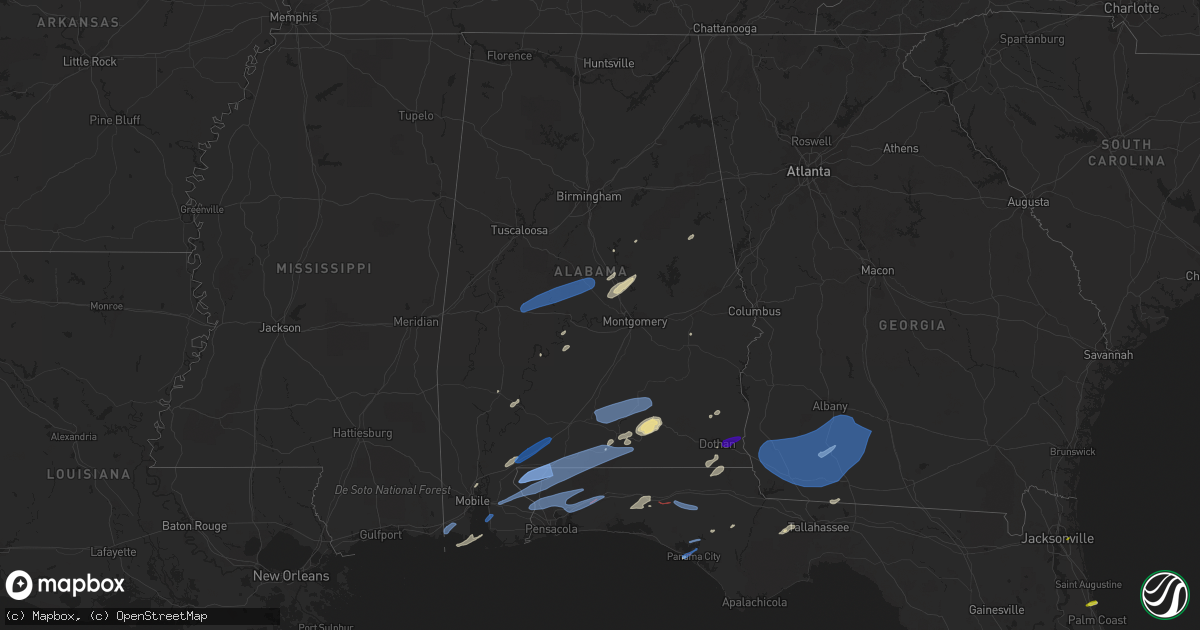
Hail Map in Alabama on March 18, 2022
Get this storm
March 18 map
$229
one time, instant access
Download today. No call, no setup
Keep the $229
Bought the map and want the full workflow? Apply the entire $229 to a subscription within 7 days. None of it is wasted.
Every map, not just this one
This buys you this map. Subscription and you get every map we run, in the markets you choose from a few cities to whole states to nationwide. Plus real-time alerts the moment a storm fires.
Contact data
Name, contact info, occupancy, even credit band for addresses in the footprint. You go from where it hit to who to call.
Become the source they trust
Unlimited branding weather history reports on demand. You already have the documented answer ready for the property owner, and you are the one who showed up with it.
Property data and RoofTrace estimates
Pull up any address you have got, its value and the exact code rules for that jurisdiction, straight from One Click Code. Then RoofTrace estimates the squares, pitch, and roof value, priced the way you price.
Storm reports in Alabama
Alabama
| Date | Description |
|---|---|
| 03/18/202212:45 PM CDT | Mping report. |
| 03/18/202212:40 PM CDT | Power lines down at intersection of southland drive and south park avenue. |
| 03/18/202212:40 PM CDT | Power lines down on the 1400 block of w. Selma street. |
| 03/18/202212:35 PM CDT | Downed tree in dothan. |
| 03/18/202212:00 PM CDT | Tree down county road 248. |
| 03/18/202211:30 AM CDT | Damage to a barn on carport on rockhole bridge rd near highway 55. |
| 03/18/202211:15 AM CDT | Tree down blocking roadway on cr 215 near victoria cemetery. |
| 03/18/202211:06 AM CDT | Reports of downed trees on kirkland road just east of hwy 31. Time estimated on radar. |
| 03/18/202210:37 AM CDT | Usa mesonet site in fairhope measured a thunderstorm wind gust of 61 mph. |
| 03/18/20229:04 AM CDT | *** 10 inj *** a narrow swath of intense wind gusts estimated at 90 to 100mph affected a mobile home park where several mobile homes were rolled/destroyed. The surround |
| 03/18/20228:55 AM CDT | Several mobile homes damaged or destroyed. Several injuries reported. Time estimated. |
| 03/18/20228:07 AM CDT | Tree blocking the roadway. Wind gust to 39 mph at pell city airport reported at 8:15 am. |
| 03/18/20228:07 AM CDT | Tree blocking the roadway. Wind gust to 39 mph at pell city airport reported at 8:15 am. |
| 03/18/20226:40 AM CDT | At 1139 AM CDT, severe thunderstorms were located along a line extending from near Opp to 8 miles north of Point Baker, moving southeast at 35 mph. HAZARD...60 mph wind gusts and quarter size hail. SOURCE...Radar indicated. IMPACT...Hail damage to vehicles is expected. Expect wind damage to roofs, siding, and trees. Locations impacted include... Crestview, Andalusia, Opp, Florala, Baker, Laurel Hill and Lockhart. |
| 03/18/20226:06 AM CDT | At 1106 AM CDT, a severe thunderstorm was located over Calvert, or 12 miles east of Citronelle, moving east at 65 mph. HAZARD...60 mph wind gusts. SOURCE...Radar indicated. IMPACT...Expect damage to roofs, siding, and trees. Locations impacted include... McCullough, Uriah, Mount Vernon, Calvert, I65 And CR 1, Movico, I65 And AL 113, I65 And AL 21 and Poarch Creek Reservation. |
| 03/18/20226:00 AM CDT | At 1100 AM CDT, severe thunderstorms were located 5 miles south of Andalusia, moving east at 45 mph. HAZARD...70 mph wind gusts and quarter size hail. SOURCE...Radar indicated. IMPACT...Hail damage to vehicles is expected. Expect considerable tree damage. Wind damage is also likely to mobile homes, roofs, and outbuildings. Locations impacted include... Andalusia, Opp, Florala, River Falls, Red Level, Lockhart, Dozier, Heath and Gantt. |
| 03/18/20225:36 AM CDT | At 1035 AM CDT, a severe thunderstorm was located 6 miles northwest of Brewton, moving east at 40 mph. HAZARD...60 mph wind gusts and quarter size hail. SOURCE...Radar indicated. IMPACT...Hail damage to vehicles is expected. Expect wind damage to roofs, siding, and trees. Locations impacted include... Brewton, Evergreen, Flomaton, East Brewton, Castleberry, Pollard, Riverview and I65 And US 84. |
| 03/18/20225:25 AM CDT | At 1025 AM CDT, severe thunderstorms were located along a line extending from 7 miles north of Dozier to 10 miles northwest of Laurel Hill, moving east at 55 mph. HAZARD...60 mph wind gusts. SOURCE...Radar indicated. IMPACT...Expect damage to roofs, siding, and trees. Locations impacted include... Elba, Enterprise, Fort Rucker, New Brockton, Lee, Kinston, Mixons Crossroads, Curtis, Carl Folsom A/p, Central City, Camp Humming Hills, Clintonville, Roeton, Camp Alaflo Bsa, Arcus, Enterprise Municipal A/P, Alberton, Richburg, Victoria and Danleys Crossroads. |
| 03/18/20225:16 AM CDT | At 1015 AM CDT, a severe thunderstorm was located 9 miles southwest of River Falls, or 9 miles west of Andalusia, moving east at 45 mph. HAZARD...60 mph wind gusts and quarter size hail. SOURCE...Radar indicated. IMPACT...Hail damage to vehicles is expected. Expect wind damage to roofs, siding, and trees. Locations impacted include... Andalusia, Opp and Heath. |
| 03/18/20225:09 AM CDT | At 1008 AM CDT, a severe thunderstorm was located 9 miles east of Petit Bois Island, or 15 miles west of Dauphin Island, moving northeast at 60 mph. HAZARD...60 mph wind gusts and penny size hail. SOURCE...Radar indicated. IMPACT...Expect damage to roofs, siding, and trees. Locations impacted include... Fairhope, Foley, Orange Beach, Point Clear, Dauphin Island, Magnolia Springs, Bon Secour, Summerdale, Silverhill, Fort Morgan and Alabama Port. |
| 03/18/20224:58 AM CDT | At 958 AM CDT, a severe thunderstorm was located 8 miles east of Evergreen, moving northeast at 45 mph. HAZARD...60 mph wind gusts and quarter size hail. SOURCE...Radar indicated. IMPACT...Hail damage to vehicles is expected. Expect wind damage to roofs, siding, and trees. Locations impacted include... Andalusia, Luverne, Brantley, McKenzie, River Falls, Red Level, Rutledge, Dozier, Heath, Gantt, Glenwood and Petrey. |
| 03/18/20223:09 AM CDT | At 808 AM CDT, a severe thunderstorm was located 8 miles south of Whatley, or 11 miles east of Jackson, moving northeast at 60 mph. HAZARD...60 mph wind gusts and quarter size hail. SOURCE...Radar indicated. IMPACT...Hail damage to vehicles is expected. Expect wind damage to roofs, siding, and trees. Locations impacted include... Peterman, Beatrice, Vredenburgh and Pine Apple. |
| 03/18/20223:03 AM CDT | At 803 AM CDT, severe thunderstorms were located along a line extending from 5 miles east of Clara to 7 miles west of State Line to 5 miles northeast of Beaumont, moving east at 60 mph. HAZARD...60 mph wind gusts and penny size hail. SOURCE...Radar indicated. IMPACT...Expect damage to roofs, siding, and trees. Locations impacted include... Jackson, Grove Hill, Chatom, Saint Stephens, Wagarville, Leroy, Clara, Deer Park, Tibbie, Millry, State Line, Buckatunna, Fruitdale and McIntosh. |
| 03/18/20222:59 AM CDT | At 759 AM CDT, severe thunderstorms were located along a line extending from Coosa Island to Fayetteville, moving northeast at 45 mph. HAZARD...60 mph wind gusts and penny size hail. SOURCE...Radar indicated. IMPACT...Expect damage to roofs, siding, and trees. Locations impacted include... Talladega, Sylacauga, Childersburg, Ashland, Munford, Waldo, Alpine Bay Resort, Winterboro, Fayetteville, Alpine, Sycamore, Logan Martin Lake, Country Club Estates, Cleveland Crossroads, Gantts Quarry, Varnons, Camp Mac, Ironaton, Millerville and Mignon. |
| 03/18/20222:52 AM CDT | At 752 AM CDT, severe thunderstorms were located along a line extending from near Lay Lake Dam to near White Hall, moving east at 60 mph. HAZARD...60 mph wind gusts and penny size hail. SOURCE...Radar indicated. IMPACT...Expect damage to roofs, siding, and trees. Locations impacted include... Prattville, Alexander City, Millbrook, Wetumpka, Tallassee, Goodwater, Rockford, Kellyton, Equality, Stewartville, Weogufka, Elmore, Coosada, Deatsville, Eclectic, Autaugaville, Jacksons' Gap, Martin Dam, Dollar and Bradford. |
| 03/18/20222:45 AM CDT | At 745 AM CDT, a severe thunderstorm was located 7 miles southwest of Mobile Regional Airport, or 9 miles north of Grand Bay, moving northeast at 35 mph. HAZARD...70 mph wind gusts. SOURCE...Radar indicated. IMPACT...Expect considerable tree damage. Damage is likely to mobile homes, roofs, and outbuildings. Locations impacted include... Creola, Chunchula, Axis, Mount Vernon, Semmes, Movico and Mobile Regional Airport. |
| 03/18/20222:10 AM CDT | At 710 AM CDT, a severe thunderstorm was located near Marion, moving northeast at 60 mph. HAZARD...60 mph wind gusts and nickel size hail. SOURCE...Radar indicated. IMPACT...Expect damage to roofs, siding, and trees. Locations impacted include... Clanton, Valley Grande, Maplesville, Billingsley, Plecher, Vida Junction, Parnell, Paul M Grist State Park, Pooles Crossroads, Radford, Stanton, Summerfield, Valley Creek Junction, Plantersville, Suttle, Oakmulgee, Sprott, Isabella, Barrett Creek and Dawson Mill. |
| 03/18/20221:57 AM CDT | At 656 AM CDT, severe thunderstorms were located along a line extending from near Uniontown to near Thomasville, moving east at 45 mph. HAZARD...60 mph wind gusts and penny size hail. SOURCE...Radar indicated. IMPACT...Expect damage to roofs, siding, and trees. Locations impacted include... Thomasville, Camden, Pine Hill and Yellow Bluff. |
| 03/18/20221:22 AM CDT | At 622 AM CDT, severe thunderstorms were located along a line extending from 6 miles northwest of Pennington to 6 miles southeast of Butler, moving east at 60 mph. HAZARD...60 mph wind gusts and quarter size hail. SOURCE...Radar indicated. IMPACT...Hail damage to vehicles is expected. Expect wind damage to roofs, siding, and trees. Locations impacted include... Linden, Thomaston, Sweet Water, Myrtlewood, Dayton, Putnam, Freddie Jones Field, Pin Hook, Shawnee, Nanafalia, Consul, Magnolia, Wayne, Surginer, Miller, Chickasaw State Park, Dixons Mill, Vineland, Half Acre and Carleys. |
| 03/18/20221:18 AM CDT | At 618 AM CDT, severe thunderstorms were located along a line extending from 4 miles north of Lisman to 4 miles southwest of Silas, moving east at 65 mph. HAZARD...70 mph wind gusts and nickel size hail. SOURCE...Radar indicated. IMPACT...Expect considerable tree damage. Damage is likely to mobile homes, roofs, and outbuildings. Locations impacted include... Thomasville, Pine Hill, Coffeeville, Fulton and Yellow Bluff. |
| 03/18/202212:24 AM CDT | At 523 AM CDT, severe thunderstorms were located along a line extending from 3 miles north of Turnerville to Sanford, moving east at 60 mph. HAZARD...60 mph wind gusts and nickel size hail. SOURCE...Radar indicated. IMPACT...Expect damage to roofs, siding, and trees. Locations impacted include... Waynesboro, Butler, Clara, Lisman, Millry, State Line, Buckatunna, Silas, Pennington, Gilbertown and Toxey. |
| 03/18/202212:07 AM CDT | At 507 AM CDT, severe thunderstorms were located along a line extending from near Garlandville to 8 miles southwest of Moss to near Improve, moving east at 55 mph. HAZARD...60 mph wind gusts and nickel size hail. SOURCE...Radar indicated. IMPACT...Expect damage to roofs, siding, and trees. Severe thunderstorms will be near... Moss around 515 AM CDT. Rose Hill around 520 AM CDT. Sandersville around 525 AM CDT. Stonewall, Heidelberg and Moselle around 530 AM CDT. Goodwater and Stafford Springs around 535 AM CDT. Ellisville and Sable around 540 AM CDT. Ovett and Tuckers Crossing around 545 AM CDT. De Soto around 550 AM CDT.Other locations impacted by these severe thunderstorms includePachuta and Shubuta. |
All States Impacted by Hail Map on March 18, 2022
Cities Impacted by Hail Map on March 18, 2022
- Panama City, FL
- Marbury, AL
- Titus, AL
- Deatsville, AL
- Lake Wales, FL
- Newville, AL
- Doniphan, MO
- Maynard, AR
- Warm Springs, AR
- Frostproof, FL
- Saint Augustine, FL
- Midland City, AL
- Ozark, AL
- Calvert City, KY
- Benton, KY
- Symsonia, KY
- Gilbertsville, KY
- Grand Rivers, KY
- Kuttawa, KY
- Campbellton, FL
- Graceville, FL
- Cottonwood, AL
- Valley Springs, AR
- Yellville, AR
- Opp, AL
- Elba, AL
- Kinston, AL
- Paoli, IN
- Hardinsburg, IN
- Defuniak Springs, FL
- Quincy, FL
- Eddyville, KY
- Boaz, KY
- Paducah, KY
- Hickory, KY
- Verbena, AL
- Prattville, AL
- Clanton, AL
- Dothan, AL
- Grove Hill, AL
- Sardis, AL
- Sylacauga, AL
- Caneyville, KY
- Leitchfield, KY
- Falls Of Rough, KY
- Bay Minette, AL
- Perdido, AL
- Atmore, AL
- Andalusia, AL
- Tuskegee, AL
- Christmas, FL
- Thomasville, GA
- Tallahassee, FL
- Youngstown, FL
- Rockford, AL
- Whatley, AL
- Titusville, FL
- Mims, FL
- Kenansville, FL
- Minter, AL
- Venus, FL
- Saraland, AL
- Hosford, FL
- Cragford, AL
- Wadley, AL
- Moore Haven, FL
- Labelle, FL
- Orlando, FL
- Pelham, GA
- Camilla, GA
- Coden, AL
- Camden, AL
- Slocomb, AL
- Clarksville, FL
- Altha, FL
- Sebring, FL
- Shelby, AL
- McHenry, KY
- Cromwell, KY
- Olaton, KY
- Beaver Dam, KY
- Centertown, KY
- Rosine, KY
- Horse Branch, KY
- Hartford, KY
- Brandenburg, KY
- Muldraugh, KY
- Elizabeth, IN
- Ekron, KY
- Vine Grove, KY
- Irvington, KY
- Fairdale, KY
- Louisville, KY
- West Point, KY
- Garfield, KY
- Guston, KY
- Elizabethtown, KY
- Cecilia, KY
- Shelbyville, KY
- Shepherdsville, KY
- Lebanon Junction, KY
- Coxs Creek, KY
- Taylorsville, KY
- Waddy, KY
- Selma, AL
- Marion, AL
- Maplesville, AL
- Faunsdale, AL
- Billingsley, AL
- Plantersville, AL
- Stanton, AL
- Newbern, AL
- Uniontown, AL
- Marion Junction, AL
- Irvington, AL
- Grand Bay, AL
- Luverne, AL
- Brantley, AL
- Greenville, AL
- McKenzie, AL
- Dozier, AL
- Georgiana, AL
- Rutledge, AL
- Red Level, AL
- Glenwood, AL
- Fairhope, AL
- McDavid, FL
- Jay, FL
- Robertsdale, AL
- Wing, AL
- Milton, FL
- Flomaton, AL
- Molino, FL
- Loxley, AL
- Century, FL
- Brewton, AL
- Florala, AL
- Holt, FL
- Bagdad, FL
- Crestview, FL
- Baker, FL
- Cantonment, FL
- Repton, AL
- Chipley, FL
- Vernon, FL
- Caryville, FL
- Panama City Beach, FL
- Lynn Haven, FL
- Norman Park, GA
- Bainbridge, GA
- Ochlocknee, GA
- Moultrie, GA
- Coolidge, GA
- Iron City, GA
- Newton, GA
- Meigs, GA
- Damascus, GA
- Donalsonville, GA
- Albany, GA
- Blakely, GA
- Jakin, GA
- Brinson, GA
- Hartsfield, GA
- Whigham, GA
- Cairo, GA
- Colquitt, GA
- Sale City, GA
- Doerun, GA
- Climax, GA
- Baconton, GA
- Sylvester, GA
- Funston, GA
- Leary, GA
- Sumner, GA
- Cowarts, AL
- Webb, AL
- Columbia, AL
- Ashford, AL
- Princeton, KY
- Jacksonville, FL
- Salem, IN
- Campbellsburg, IN
- Ponce De Leon, FL
- Rineyville, KY


