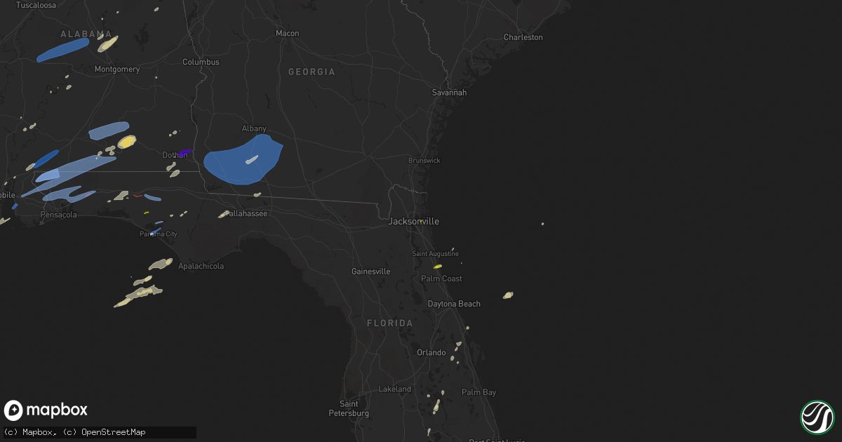
Hail Map on March 18, 2022
Get this storm
March 18 map
$229
one time, instant access
Download today. No call, no setup
Keep the $229
Bought the map and want the full workflow? Apply the entire $229 to a subscription within 7 days. None of it is wasted.
Every map, not just this one
This buys you this map. Subscription and you get every map we run, in the markets you choose from a few cities to whole states to nationwide. Plus real-time alerts the moment a storm fires.
Contact data
Name, contact info, occupancy, even credit band for addresses in the footprint. You go from where it hit to who to call.
Become the source they trust
Unlimited branding weather history reports on demand. You already have the documented answer ready for the property owner, and you are the one who showed up with it.
Property data and RoofTrace estimates
Pull up any address you have got, its value and the exact code rules for that jurisdiction, straight from One Click Code. Then RoofTrace estimates the squares, pitch, and roof value, priced the way you price.
Storm reports
Alabama
| Date | Description |
|---|---|
| 03/18/202212:45 PM CDT | Mping report. |
| 03/18/202212:40 PM CDT | Power lines down on the 1400 block of w. Selma street. |
| 03/18/202212:40 PM CDT | Power lines down at intersection of southland drive and south park avenue. |
| 03/18/202212:35 PM CDT | Downed tree in dothan. |
| 03/18/202212:00 PM CDT | Tree down county road 248. |
| 03/18/202211:30 AM CDT | Damage to a barn on carport on rockhole bridge rd near highway 55. |
| 03/18/202211:15 AM CDT | Tree down blocking roadway on cr 215 near victoria cemetery. |
| 03/18/202211:06 AM CDT | Reports of downed trees on kirkland road just east of hwy 31. Time estimated on radar. |
| 03/18/202210:37 AM CDT | Usa mesonet site in fairhope measured a thunderstorm wind gust of 61 mph. |
| 03/18/20229:04 AM CDT | *** 10 inj *** a narrow swath of intense wind gusts estimated at 90 to 100mph affected a mobile home park where several mobile homes were rolled/destroyed. The surround |
| 03/18/20228:55 AM CDT | Several mobile homes damaged or destroyed. Several injuries reported. Time estimated. |
| 03/18/20228:07 AM CDT | Tree blocking the roadway. Wind gust to 39 mph at pell city airport reported at 8:15 am. |
| 03/18/20228:07 AM CDT | Tree blocking the roadway. Wind gust to 39 mph at pell city airport reported at 8:15 am. |
| 03/18/20226:40 AM CDT | At 1139 AM CDT, severe thunderstorms were located along a line extending from near Opp to 8 miles north of Point Baker, moving southeast at 35 mph. HAZARD...60 mph wind gusts and quarter size hail. SOURCE...Radar indicated. IMPACT...Hail damage to vehicles is expected. Expect wind damage to roofs, siding, and trees. Locations impacted include... Crestview, Andalusia, Opp, Florala, Baker, Laurel Hill and Lockhart. |
| 03/18/20226:06 AM CDT | At 1106 AM CDT, a severe thunderstorm was located over Calvert, or 12 miles east of Citronelle, moving east at 65 mph. HAZARD...60 mph wind gusts. SOURCE...Radar indicated. IMPACT...Expect damage to roofs, siding, and trees. Locations impacted include... McCullough, Uriah, Mount Vernon, Calvert, I65 And CR 1, Movico, I65 And AL 113, I65 And AL 21 and Poarch Creek Reservation. |
| 03/18/20226:00 AM CDT | At 1100 AM CDT, severe thunderstorms were located 5 miles south of Andalusia, moving east at 45 mph. HAZARD...70 mph wind gusts and quarter size hail. SOURCE...Radar indicated. IMPACT...Hail damage to vehicles is expected. Expect considerable tree damage. Wind damage is also likely to mobile homes, roofs, and outbuildings. Locations impacted include... Andalusia, Opp, Florala, River Falls, Red Level, Lockhart, Dozier, Heath and Gantt. |
| 03/18/20225:36 AM CDT | At 1035 AM CDT, a severe thunderstorm was located 6 miles northwest of Brewton, moving east at 40 mph. HAZARD...60 mph wind gusts and quarter size hail. SOURCE...Radar indicated. IMPACT...Hail damage to vehicles is expected. Expect wind damage to roofs, siding, and trees. Locations impacted include... Brewton, Evergreen, Flomaton, East Brewton, Castleberry, Pollard, Riverview and I65 And US 84. |
| 03/18/20225:25 AM CDT | At 1025 AM CDT, severe thunderstorms were located along a line extending from 7 miles north of Dozier to 10 miles northwest of Laurel Hill, moving east at 55 mph. HAZARD...60 mph wind gusts. SOURCE...Radar indicated. IMPACT...Expect damage to roofs, siding, and trees. Locations impacted include... Elba, Enterprise, Fort Rucker, New Brockton, Lee, Kinston, Mixons Crossroads, Curtis, Carl Folsom A/p, Central City, Camp Humming Hills, Clintonville, Roeton, Camp Alaflo Bsa, Arcus, Enterprise Municipal A/P, Alberton, Richburg, Victoria and Danleys Crossroads. |
| 03/18/20225:16 AM CDT | At 1015 AM CDT, a severe thunderstorm was located 9 miles southwest of River Falls, or 9 miles west of Andalusia, moving east at 45 mph. HAZARD...60 mph wind gusts and quarter size hail. SOURCE...Radar indicated. IMPACT...Hail damage to vehicles is expected. Expect wind damage to roofs, siding, and trees. Locations impacted include... Andalusia, Opp and Heath. |
| 03/18/20225:09 AM CDT | At 1008 AM CDT, a severe thunderstorm was located 9 miles east of Petit Bois Island, or 15 miles west of Dauphin Island, moving northeast at 60 mph. HAZARD...60 mph wind gusts and penny size hail. SOURCE...Radar indicated. IMPACT...Expect damage to roofs, siding, and trees. Locations impacted include... Fairhope, Foley, Orange Beach, Point Clear, Dauphin Island, Magnolia Springs, Bon Secour, Summerdale, Silverhill, Fort Morgan and Alabama Port. |
| 03/18/20224:58 AM CDT | At 958 AM CDT, a severe thunderstorm was located 8 miles east of Evergreen, moving northeast at 45 mph. HAZARD...60 mph wind gusts and quarter size hail. SOURCE...Radar indicated. IMPACT...Hail damage to vehicles is expected. Expect wind damage to roofs, siding, and trees. Locations impacted include... Andalusia, Luverne, Brantley, McKenzie, River Falls, Red Level, Rutledge, Dozier, Heath, Gantt, Glenwood and Petrey. |
| 03/18/20223:09 AM CDT | At 808 AM CDT, a severe thunderstorm was located 8 miles south of Whatley, or 11 miles east of Jackson, moving northeast at 60 mph. HAZARD...60 mph wind gusts and quarter size hail. SOURCE...Radar indicated. IMPACT...Hail damage to vehicles is expected. Expect wind damage to roofs, siding, and trees. Locations impacted include... Peterman, Beatrice, Vredenburgh and Pine Apple. |
| 03/18/20223:03 AM CDT | At 803 AM CDT, severe thunderstorms were located along a line extending from 5 miles east of Clara to 7 miles west of State Line to 5 miles northeast of Beaumont, moving east at 60 mph. HAZARD...60 mph wind gusts and penny size hail. SOURCE...Radar indicated. IMPACT...Expect damage to roofs, siding, and trees. Locations impacted include... Jackson, Grove Hill, Chatom, Saint Stephens, Wagarville, Leroy, Clara, Deer Park, Tibbie, Millry, State Line, Buckatunna, Fruitdale and McIntosh. |
| 03/18/20222:59 AM CDT | At 759 AM CDT, severe thunderstorms were located along a line extending from Coosa Island to Fayetteville, moving northeast at 45 mph. HAZARD...60 mph wind gusts and penny size hail. SOURCE...Radar indicated. IMPACT...Expect damage to roofs, siding, and trees. Locations impacted include... Talladega, Sylacauga, Childersburg, Ashland, Munford, Waldo, Alpine Bay Resort, Winterboro, Fayetteville, Alpine, Sycamore, Logan Martin Lake, Country Club Estates, Cleveland Crossroads, Gantts Quarry, Varnons, Camp Mac, Ironaton, Millerville and Mignon. |
| 03/18/20222:52 AM CDT | At 752 AM CDT, severe thunderstorms were located along a line extending from near Lay Lake Dam to near White Hall, moving east at 60 mph. HAZARD...60 mph wind gusts and penny size hail. SOURCE...Radar indicated. IMPACT...Expect damage to roofs, siding, and trees. Locations impacted include... Prattville, Alexander City, Millbrook, Wetumpka, Tallassee, Goodwater, Rockford, Kellyton, Equality, Stewartville, Weogufka, Elmore, Coosada, Deatsville, Eclectic, Autaugaville, Jacksons' Gap, Martin Dam, Dollar and Bradford. |
| 03/18/20222:45 AM CDT | At 745 AM CDT, a severe thunderstorm was located 7 miles southwest of Mobile Regional Airport, or 9 miles north of Grand Bay, moving northeast at 35 mph. HAZARD...70 mph wind gusts. SOURCE...Radar indicated. IMPACT...Expect considerable tree damage. Damage is likely to mobile homes, roofs, and outbuildings. Locations impacted include... Creola, Chunchula, Axis, Mount Vernon, Semmes, Movico and Mobile Regional Airport. |
| 03/18/20222:10 AM CDT | At 710 AM CDT, a severe thunderstorm was located near Marion, moving northeast at 60 mph. HAZARD...60 mph wind gusts and nickel size hail. SOURCE...Radar indicated. IMPACT...Expect damage to roofs, siding, and trees. Locations impacted include... Clanton, Valley Grande, Maplesville, Billingsley, Plecher, Vida Junction, Parnell, Paul M Grist State Park, Pooles Crossroads, Radford, Stanton, Summerfield, Valley Creek Junction, Plantersville, Suttle, Oakmulgee, Sprott, Isabella, Barrett Creek and Dawson Mill. |
| 03/18/20221:57 AM CDT | At 656 AM CDT, severe thunderstorms were located along a line extending from near Uniontown to near Thomasville, moving east at 45 mph. HAZARD...60 mph wind gusts and penny size hail. SOURCE...Radar indicated. IMPACT...Expect damage to roofs, siding, and trees. Locations impacted include... Thomasville, Camden, Pine Hill and Yellow Bluff. |
| 03/18/20221:22 AM CDT | At 622 AM CDT, severe thunderstorms were located along a line extending from 6 miles northwest of Pennington to 6 miles southeast of Butler, moving east at 60 mph. HAZARD...60 mph wind gusts and quarter size hail. SOURCE...Radar indicated. IMPACT...Hail damage to vehicles is expected. Expect wind damage to roofs, siding, and trees. Locations impacted include... Linden, Thomaston, Sweet Water, Myrtlewood, Dayton, Putnam, Freddie Jones Field, Pin Hook, Shawnee, Nanafalia, Consul, Magnolia, Wayne, Surginer, Miller, Chickasaw State Park, Dixons Mill, Vineland, Half Acre and Carleys. |
| 03/18/20221:18 AM CDT | At 618 AM CDT, severe thunderstorms were located along a line extending from 4 miles north of Lisman to 4 miles southwest of Silas, moving east at 65 mph. HAZARD...70 mph wind gusts and nickel size hail. SOURCE...Radar indicated. IMPACT...Expect considerable tree damage. Damage is likely to mobile homes, roofs, and outbuildings. Locations impacted include... Thomasville, Pine Hill, Coffeeville, Fulton and Yellow Bluff. |
| 03/18/202212:24 AM CDT | At 523 AM CDT, severe thunderstorms were located along a line extending from 3 miles north of Turnerville to Sanford, moving east at 60 mph. HAZARD...60 mph wind gusts and nickel size hail. SOURCE...Radar indicated. IMPACT...Expect damage to roofs, siding, and trees. Locations impacted include... Waynesboro, Butler, Clara, Lisman, Millry, State Line, Buckatunna, Silas, Pennington, Gilbertown and Toxey. |
| 03/18/202212:07 AM CDT | At 507 AM CDT, severe thunderstorms were located along a line extending from near Garlandville to 8 miles southwest of Moss to near Improve, moving east at 55 mph. HAZARD...60 mph wind gusts and nickel size hail. SOURCE...Radar indicated. IMPACT...Expect damage to roofs, siding, and trees. Severe thunderstorms will be near... Moss around 515 AM CDT. Rose Hill around 520 AM CDT. Sandersville around 525 AM CDT. Stonewall, Heidelberg and Moselle around 530 AM CDT. Goodwater and Stafford Springs around 535 AM CDT. Ellisville and Sable around 540 AM CDT. Ovett and Tuckers Crossing around 545 AM CDT. De Soto around 550 AM CDT.Other locations impacted by these severe thunderstorms includePachuta and Shubuta. |
Georgia
| Date | Description |
|---|---|
| 03/18/20222:05 PM CDT | Damage to a sheds roof on a farm at 1047 cedar springs road. Part of a metal roof was tossed into nearby trees. |
| 03/18/20221:35 PM CDT | Awos station kbge bainbridge. |
| 03/18/20221:18 PM CDT | Report from mping: 1-inch tree limbs broken; shingles blown off. |
| 03/18/20221:18 PM CDT | Power line down connecting to traffic light. |
| 03/18/202210:26 AM CDT | Tree down on a house in woodstock on newcastle walk |
| 03/18/20229:37 AM CDT | Tree downed onto a barn and pool house on ridgeview drive |
| 03/18/20226:30 AM CDT | A follower on twitter posted a picture of downed trees and powerlines on briar cliff drive this morning from thomasville... Ga. Location is estimated. |
| 03/18/202212:25 AM CDT | At 524 PM EDT, a severe thunderstorm was located near Needmore, or near Fargo, moving northeast at 40 mph. HAZARD...60 mph wind gusts and quarter size hail. SOURCE...Radar indicated. IMPACT...Hail damage to vehicles is expected. Expect wind damage to roofs, siding, and trees. Locations impacted include... Fargo and Needmore. |
| 03/17/202211:16 PM CDT | At 416 PM CDT, severe thunderstorms were located along a line extending from near Cottonwood to 7 miles southeast of Chipley, moving east at 45 mph. HAZARD...60 mph wind gusts. SOURCE...Radar indicated. IMPACT...Expect damage to roofs, siding, and trees. Locations impacted include... Marianna, Chattahoochee, Malone, Sneads, Grand Ridge, Greenwood, Bascom, Blue Spring, Union City, Lovedale, Haynes, Sink Creek, Dellwood, Star, Two Egg, Simsville, Cypress, Hornsville, Alliance and Chipola Terrace. |
| 03/17/20229:37 PM CDT | At 236 PM EDT, severe thunderstorms were located along a line extending from 10 miles west of Albany to 9 miles north of West Bainbridge, moving northeast at 40 mph. HAZARD...60 mph wind gusts. SOURCE...Radar indicated. IMPACT...Expect damage to roofs, siding, and trees. Locations impacted include... Newton, Albany, Sylvester, Pelham, Putney, Camilla, Moultrie, Baconton, Poulan, Doerun, Ochlocknee, East Albany, Marine Corps Logistics Base, Turner City, Walker, Terrell, Schley, Funston, Sumner and Sale City. |
Indiana
| Date | Description |
|---|---|
| 03/18/20223:26 AM CDT | At 826 PM EDT, a severe thunderstorm was located 8 miles northeast of Salem, or 17 miles south of Seymour, moving northeast at 35 mph. HAZARD...60 mph wind gusts and quarter size hail. SOURCE...Radar indicated. IMPACT...Hail damage to vehicles is expected. Expect wind damage to roofs, siding, and trees. This severe thunderstorm will be near... Crothersville around 845 PM EDT.Other locations in the path of this severe thunderstorm include ParisCrossing, Hayden, Vernon, North Vernon, Butlerville and Nebraska.This includes Interstate 65 between mile markers 37 and 47. |
| 03/18/20223:07 AM CDT | At 806 PM EDT, a severe thunderstorm was located 9 miles southeast of Paoli, moving northeast at 35 mph. HAZARD...60 mph wind gusts and penny size hail. SOURCE...Radar indicated. IMPACT...Expect damage to roofs, siding, and trees. Locations impacted include... Salem. |
| 03/18/20222:19 AM CDT | At 719 PM EDT, a severe thunderstorm was located 7 miles west of English, moving northeast at 40 mph. HAZARD...60 mph wind gusts and penny size hail. SOURCE...Radar indicated. IMPACT...Expect damage to roofs, siding, and trees. This severe thunderstorm will be near... English around 730 PM EDT. |
| 03/17/20227:13 PM CDT | Few trees down. Possible tornado. |
| 03/17/20227:10 PM CDT | Possible tornado. |
| 03/17/20227:10 PM CDT | Corrects location of previous tstm wnd dmg report from 1 nw new philadelphia. Few trees down. Possible tornado. |
| 03/17/20227:09 PM CDT | Trees down. Possible tornado. |
| 03/17/20227:08 PM CDT | Tree down. Possible tornado. |
Kentucky
| Date | Description |
|---|---|
| 03/18/20225:55 PM CDT | A local report indicates 1.00 inch wind near GRAND RIVERS |
| 03/18/20225:48 PM CDT | A local report indicates 1.25 inch wind near GILBERTSVILLE |
| 03/18/20225:41 PM CDT | A local report indicates 70 MPH wind near 1 SSE GILBERTSVILLE |
| 03/18/20225:33 PM CDT | A local report indicates 60 MPH wind near 1 NW SYMSONIA |
| 03/18/20229:41 AM CDT | Via nws chat reports of storm damage to homes on spear lane around st. John. |
| 03/18/20226:56 AM CDT | At 1156 PM EDT, a severe thunderstorm was located near Shelbyville, moving northeast at 40 mph. HAZARD...60 mph wind gusts. SOURCE...Radar indicated. IMPACT...Expect damage to roofs, siding, and trees. This severe thunderstorm will be near... Shelbyville around 1205 AM EDT. |
| 03/18/20226:51 AM CDT | At 1151 PM EDT, a severe thunderstorm was located near Coldstream, moving northeast at 40 mph. HAZARD...65 mph wind gusts. SOURCE...Radar indicated. IMPACT...Expect damage to roofs, siding, and trees. This severe thunderstorm will be near... La Grange around 1200 AM EDT.Other locations in the path of this severe thunderstorm include NewCastle. |
| 03/18/20226:27 AM CDT | At 1127 PM EDT, a severe thunderstorm was located 10 miles east of Shepherdsville, moving northeast at 40 mph. HAZARD...60 mph wind gusts. SOURCE...Radar indicated. IMPACT...Expect damage to roofs, siding, and trees. This severe thunderstorm will be near... Taylorsville around 1145 PM EDT. |
| 03/18/20226:04 AM CDT | At 1104 PM EDT, a severe thunderstorm was located 10 miles south of Shepherdsville, moving northeast at 35 mph. HAZARD...60 mph wind gusts. SOURCE...Radar indicated. IMPACT...Expect damage to roofs, siding, and trees. This severe thunderstorm will remain over mainly rural areas of northwestern Nelson and eastern Bullitt Counties, including the following locations... Ridgetop, Solitude, Bardstown Junction, Hobbs, Scuffletown, Deatsville, Cedar Grove, Belmont, Lebanon Junction and Lotus. |
| 03/18/20225:42 AM CDT | At 1042 PM EDT, a severe thunderstorm was located near Elizabethtown, moving northeast at 35 mph. HAZARD...60 mph wind gusts and quarter size hail. SOURCE...Radar indicated. IMPACT...Hail damage to vehicles is expected. Expect wind damage to roofs, siding, and trees. This severe thunderstorm will be near... Elizabethtown around 1050 PM EDT. |
| 03/18/20225:18 AM CDT | At 1018 PM EDT/918 PM CDT/, a severe thunderstorm was located 9 miles east of Hardinsburg, moving northeast at 30 mph. HAZARD...60 mph wind gusts. SOURCE...Radar indicated. IMPACT...Expect damage to roofs, siding, and trees. This severe thunderstorm will remain over mainly rural areas of southeastern Meade and east central Breckinridge Counties, including the following locations... Maples Corner, Guston, Garfield, Graysville, Big Spring, Buck Grove, Hillgrove, Ekron, Garrett and Bewleyville. |
| 03/18/20225:04 AM CDT | At 1004 PM EDT/904 PM CDT/, a severe thunderstorm was located 7 miles northwest of Leitchfield, moving east at 35 mph. HAZARD...60 mph wind gusts. SOURCE...Radar indicated. IMPACT...Expect damage to roofs, siding, and trees. This severe thunderstorm will remain over mainly rural areas of northeastern Grayson, southwestern Hardin and southeastern Breckinridge Counties, including the following locations... Dyer, Constantine, Limp, Saint Paul, Hudson, Vertrees, Cobblers Knob, West Clifty, Solway and Tar Hill. |
| 03/18/20223:27 AM CDT | At 826 PM CDT, a severe thunderstorm was located 8 miles east of Hartford, moving east at 40 mph. HAZARD...60 mph wind gusts. SOURCE...Radar indicated. IMPACT...Expect damage to roofs, siding, and trees. This severe thunderstorm will remain over mainly rural areas of western Grayson, southwestern Breckinridge and east central Ohio Counties, including the following locations... Horse Branch, Steff, Shreve, Tousey, Windy Hill, Caneyville, Do Stop, Pine Knob, Dogwalk and Jingo. |
| 03/18/202212:32 AM CDT | At 531 PM CDT, a severe thunderstorm was located near Reidland, moving east at 40 mph. HAZARD...60 mph wind gusts and quarter size hail. SOURCE...Radar indicated. IMPACT...Hail damage to vehicles is expected. Expect wind damage to roofs, siding, and trees. This severe thunderstorm will be near... Benton around 540 PM CDT. Calvert City around 545 PM CDT.This includes the following highways... Interstate 24 in Kentucky between Mile Markers 15 and 29. Interstate 69 in Kentucky between Mile Markers 39 and 51. |
| 03/17/202211:14 PM CDT | At 413 PM CDT, a severe thunderstorm was located near Big Oak Tree State Park, moving northeast at 45 mph. HAZARD...60 mph wind gusts and quarter size hail. SOURCE...Emergency management and law enforcement. IMPACT...Hail damage to vehicles is expected. Expect wind damage to roofs, siding, and trees. This severe thunderstorm will be near... Towosahgy State Historic Site around 420 PM CDT.Other locations in the path of this severe thunderstorm includeBardwell. |
| 03/17/202211:03 PM CDT | Unanchored 30x60 pole barn blown off foundation into road. Tree down. |
| 03/17/202210:36 PM CDT | Klou asos measured wind gust of 58 mph. |
| 03/17/202210:32 PM CDT | Large tree down on power lines via social media around brown park off browns lane and kresge way. |
| 03/17/202210:24 PM CDT | Ksdf asos measured 68 mph wind gust... |
| 03/17/20229:58 PM CDT | Power poles and wires down along wooldridge ferry road between ky 434 and ky 313. Time estimated via radar. |
| 03/17/20229:50 PM CDT | Large number of power poles broken along south wilson road between w.a. Jenkins road and hutcherson lane. Power company provided pictures via social media. |
| 03/17/20229:43 PM CDT | Via nws chat... Trained spotter reported power lines down in thornhill estates and damage reports from firefighters of damage in the neighborhood. |
| 03/17/20229:40 PM CDT | Significant roof damage to a home on spears lane just off st. John rd. |
| 03/17/20229:38 PM CDT | A tornado touched down near the intersection of spears lane and st. John road and continued for 10 minutes... Lifting near leasor lane at 10:48 edt. The tornado was 100 |
Missouri
| Date | Description |
|---|---|
| 03/18/20223:40 PM CDT | Multiple videos of a narrow funnel with some minor debris looking north from portageville and west from marston. Damage to a carport was reported with the tornado. Exac |
| 03/18/20222:21 PM CDT | Video shared on twitter of 1 inch hail covering the ground. |
| 03/18/20221:29 AM CDT | At 628 AM CDT, severe thunderstorms were located along a line extending from 14 miles east of Niangua to near Hartville to 8 miles east of Ava to near Price Place, moving northeast at 25 mph. HAZARD...60 mph wind gusts and nickel size hail. SOURCE...Radar indicated. IMPACT...Expect damage to roofs, siding, and trees. Locations impacted include... Bull Shoals Lake... Mountain Grove... Cabool... Gainesville... Dawson... Norwood... Hartville... Bakersfield... Theodosia... Pontiac... Huggins... Wasola... Plato... Sundown... Competition... Manes... Brixey... Willhoit... Brushyknob... Tecumseh... |
| 03/18/202212:46 AM CDT | At 546 AM CDT, severe thunderstorms were located along a line extending from near Strafford to near Fordland to 7 miles southwest of Ava, moving east at 40 mph. HAZARD...60 mph wind gusts and nickel size hail. SOURCE...Radar indicated. IMPACT...Expect damage to roofs, siding, and trees. Locations impacted include... Northeastern Springfield... Marshfield... Ava... Strafford... Seymour... Mansfield... Fordland... Norwood... Hartville... Niangua... Duncan... Diggins... Brushyknob... Grovespring... Northview... Gentryville... Rome... Vanzant... Squires... Goodhope... This includes Interstate 44 between mile markers 78 and 102. |
| 03/18/202212:08 AM CDT | At 508 AM CDT, severe thunderstorms were located along a line extending from near Battlefield to near Highlandville to near Merriam Woods to 7 miles southeast of Hollister, moving northeast at 35 mph. HAZARD...60 mph wind gusts and nickel size hail. SOURCE...Radar indicated. IMPACT...Expect damage to roofs, siding, and trees. Locations impacted include... Springfield... Nixa... Ozark... Republic... Lake Taneycomo... Bull Shoals Lake... Battlefield... Hollister... Rogersville... Strafford... Forsyth... Seymour... Merriam Woods... Sparta... Kissee Mills... Highlandville... Rockaway Beach... Fremont Hills... Fordland... Bull Creek... This includes Interstate 44 near mile marker 69, and between milemarkers 78 and 96. |
| 03/17/202211:29 PM CDT | At 429 AM CDT, severe thunderstorms were located along a line extending from near Aurora to near Galena to 6 miles southwest of Kimberling City, moving northeast at 35 mph. HAZARD...60 mph wind gusts and quarter size hail. SOURCE...Radar indicated. IMPACT...Hail damage to vehicles is expected. Expect wind damage to roofs, siding, and trees. Locations impacted include... Southwestern Springfield... Nixa... Ozark... Republic... Branson... Lake Taneycomo... Table Rock Lake... Table Rock State Park... Aurora... Battlefield... Hollister... Silver Dollar City... Kimberling City... Forsyth... Marionville... Clever... Merriam Woods... Crane... Shell Knob... Kissee Mills... This includes Interstate 44 near mile marker 69. |
| 03/17/20229:16 PM CDT | At 216 PM CDT, a severe thunderstorm was located 7 miles north of Maynard, or 9 miles southwest of Doniphan, moving east at 40 mph. HAZARD...60 mph wind gusts and quarter size hail. SOURCE...Radar indicated. IMPACT...Hail damage to vehicles is expected. Expect wind damage to roofs, siding, and trees. This severe thunderstorm will be near... Doniphan around 230 PM CDT.Other locations in the path of this severe thunderstorm include Oxly,Naylor and Fairdealing. |
Florida
| Date | Description |
|---|---|
| 03/18/20226:24 PM CDT | A 24-ft fiberglass boat |
| 03/18/20226:24 PM CDT | A 24-ft fiberglass boat |
| 03/18/20226:20 PM CDT | Extensive damage to roofs and residences were reported in the area of west 19th st between hickory ave and arthur ave. Numerous powerlines are down along calhoun ave... |
| 03/18/20226:20 PM CDT | Fd tweeted damage report on frankfurt avenue between 17th and 23rd street. Possible tornado. |
| 03/18/20226:20 PM CDT | Multiple reports of structural damage and trees and power lines down across the city. Several videos of a tornado posted to twitter. |
| 03/18/20226:20 PM CDT | One home had a collapsed roof at 1912 clay avenue. There were also power lines down in the area. Possible tornado. |
| 03/18/20226:18 PM CDT | Roofs of two homes damaged at 1812 and 1815 foster avenue. |
| 03/18/20226:15 PM CDT | Power line reported down caused by thunderstorm winds. |
| 03/18/20225:59 PM CDT | Weatherstem sensor at gulf coast state college measured this gust. |
| 03/18/20225:21 PM CDT | Quarter hail on highway 20 between highway 77 and 79. |
| 03/18/20224:48 PM CDT | Several one-inch tree limbs broken and some roof shingle damage. |
| 03/18/20224:45 PM CDT | 911 call center reported power line wires down on a home at 6545 brandemere rd north. |
| 03/18/20224:35 PM CDT | Trees down on melvin road. |
| 03/18/20224:11 PM CDT | Trees down along bryant bay road. |
| 03/18/20224:11 PM CDT | Trees down along whitehead crossing road. |
| 03/18/20223:54 PM CDT | Trees down at hinsons crossroads. |
| 03/18/20223:40 PM CDT | Multiple mature pine trees snapped off mid-trunk near 945 george montgomery road. |
| 03/18/20223:38 PM CDT | A 50-yard swatch of trees were blown down in this area. A tds was detected on kevx radar. |
| 03/18/202212:29 PM CDT | Reports of significant damage to at least four residences and multiple trees down on log lake road in holt... Fl. Tds observed on radar. Time estimated by radar. |
| 03/18/202212:28 PM CDT | Corrects previous tornado report from 4 sw galliver to include intensity rating of the tornado to ef1. A tornado touched down just west of the intersection of log lake |
| 03/18/20226:54 AM CDT | At 1153 AM CDT, severe thunderstorms were located along a line extending from 12 miles east of Riverview to near Foley, moving east at 30 mph. HAZARD...60 mph wind gusts and quarter size hail. SOURCE...Radar indicated. IMPACT...Hail damage to vehicles is expected. Expect wind damage to roofs, siding, and trees. Locations impacted include... Pensacola, Ferry Pass, Brent, West Pensacola, Ensley, Warrington, Gonzalez, Gulf Shores, Foley, Pace, Milton, Gulf Breeze, Orange Beach, Goulding, Bagdad, Lillian, Myrtle Grove, Oriole Beach, Bon Secour and Navarre. |
| 03/18/20226:47 AM CDT | At 1147 AM CDT, severe thunderstorms were located along a line extending from near Blue Springs State Park to near Florala, moving northeast at 30 mph. HAZARD...60 mph wind gusts. SOURCE...Radar indicated. IMPACT...Expect damage to roofs, siding, and trees. Locations impacted include... Daleville, Abbeville, Geneva, Enterprise, Fort Rucker, Ozark, Headland, Dothan, Hartford, Taylor, Midland City, Level Plains, Slocomb, Samson, Newton, New Brockton, Ariton, Pinckard, Malvern and Clayhatchee. |
| 03/18/20226:07 AM CDT | At 1107 AM CDT, severe thunderstorms were located along a line extending from 13 miles southwest of Red Level to near Foley, moving southeast at 20 mph. HAZARD...60 mph wind gusts and quarter size hail. SOURCE...Radar indicated. IMPACT...Hail damage to vehicles is expected. Expect wind damage to roofs, siding, and trees. Locations impacted include... Pensacola, Ferry Pass, Brent, West Pensacola, Ensley, Warrington, Gonzalez, Gulf Shores, Foley, Pace, Milton, Gulf Breeze, Brewton, Orange Beach, Goulding, Robertsdale, Point Clear, Century, Flomaton and Bagdad. |
| 03/18/20225:30 AM CDT | At 1030 AM CDT, severe thunderstorms were located along a line extending from 8 miles southwest of Bratt to 3 miles west of Loxley, moving east at 40 mph. HAZARD...60 mph wind gusts and quarter size hail. SOURCE...Radar indicated. IMPACT...Hail damage to vehicles is expected. Expect wind damage to roofs, siding, and trees. Locations impacted include... Robertsdale, Century, Flomaton, Loxley, Molino, Silverhill, Jay and Bratt. |
| 03/18/20225:05 AM CDT | At 1005 PM EDT, a severe thunderstorm was located over Mims, moving northeast at 30 mph. HAZARD...60 mph wind gusts. SOURCE...Radar indicated. IMPACT...Expect damage to roofs, siding, and trees. Locations impacted include... Titusville, Oak Hill, Haulover Canal, Mims and Playalinda Beach. |
| 03/18/20224:35 AM CDT | At 934 AM CDT, a severe thunderstorm was located over I65 And AL 21, or 8 miles north of Atmore, moving northeast at 45 mph. HAZARD...60 mph wind gusts and quarter size hail. SOURCE...Radar indicated. IMPACT...Hail damage to vehicles is expected. Expect wind damage to roofs, siding, and trees. Locations impacted include... Atmore, Evergreen, McCullough, Castleberry, Repton, I65 And US 84, I65 And CR 1, I65 And AL 113, I65 And AL 21 and Poarch Creek Reservation. |
| 03/18/20223:32 AM CDT | At 832 AM CDT, a severe thunderstorm was located near I65 And I165, or 4 miles west of Prichard, moving northeast at 65 mph. HAZARD...60 mph wind gusts and quarter size hail. SOURCE...Radar indicated. IMPACT...Hail damage to vehicles is expected. Expect wind damage to roofs, siding, and trees. Locations impacted include... Prichard, Saraland, Bay Minette, Chickasaw, Satsuma, Creola, Stockton, Axis, I65 And AL 225, I65 And I165 and I65 And AL 158. |
| 03/18/20222:01 AM CDT | At 701 PM EDT/601 PM CDT/, severe thunderstorms were located along a line extending from 15 miles southwest of Marianna to 8 miles south of Panama City Beach, moving east at 40 mph. HAZARD...60 mph wind gusts. SOURCE...Radar indicated. IMPACT...Expect damage to roofs, siding, and trees. Locations impacted include... Panama City, Lynn Haven, Panama City Beach, Callaway, Blountstown, Springfield, Mexico Beach, Hiland Park, Stonemill Creek, Tyndall Air Force Base, Orange, Bradford, Parker, Wewahitchka, Bristol, Altha, Wausau, Rock Bluff, Honeyville and Clarksville. |
| 03/18/20221:50 AM CDT | At 650 PM EDT, a severe thunderstorm was located near Crescent Beach, or 12 miles east of Hastings, moving east at 20 mph. HAZARD...60 mph wind gusts and quarter size hail. SOURCE...Radar indicated. IMPACT...Hail damage to vehicles is expected. Expect wind damage to roofs, siding, and trees. Locations impacted include... Marineland and Crescent Beach. |
| 03/18/202212:29 AM CDT | At 528 PM EDT, a severe thunderstorm was located near San Marco, or near Arlington, moving northeast at 20 mph. HAZARD...60 mph wind gusts and quarter size hail. SOURCE...Radar indicated. IMPACT...Hail damage to vehicles is expected. Expect wind damage to roofs, siding, and trees. Locations impacted include... Unf, Arlington, Neptune Beach, Craig Field, San Pablo and Fort Caroline. |
| 03/17/202211:33 PM CDT | At 433 PM CDT, severe thunderstorms were located along a line extending from 15 miles northwest of Panama City Beach to 27 miles south of Santa Rosa Beach, moving northeast at 35 mph. HAZARD...60 mph wind gusts. SOURCE...Radar indicated. IMPACT...Expect damage to roofs, siding, and trees. Locations impacted include... Panama City, Lynn Haven, Panama City Beach, Callaway, Springfield, Hiland Park, Tyndall Air Force Base, Parker, Ebro, Dirego Park, College Station, Gulf Resort Beach, West Panama City, Seaside, Bahama Beach, Bennett, Porter Lake, Brannonville, Millville and West Bay. |
| 03/17/202210:51 PM CDT | At 351 PM CDT, severe thunderstorms were located along a line extending from near Graceville to 12 miles southeast of De Funiak Springs, moving east at 40 mph. HAZARD...60 mph wind gusts. SOURCE...Radar indicated. IMPACT...Expect damage to roofs, siding, and trees. Locations impacted include... Vernon, Chipley, Graceville, Bonifay, Marianna, Bradford, Live Oak, Malone, Cottondale, Ponce De Leon, Alford, Caryville, Wausau, Esto, Westville, Campbellton, Noma, Whitehead Crossroads, Gritney and Holmes Valley. |
| 03/17/202210:06 PM CDT | At 306 PM CDT, severe thunderstorms were located along a line extending from near De Funiak Springs to near Eglin Air Force Base to near Niceville, moving east at 30 mph. HAZARD...60 mph wind gusts and quarter size hail. SOURCE...Radar indicated. IMPACT...Hail damage to vehicles is expected. Expect wind damage to roofs, siding, and trees. Locations impacted include... De Funiak Springs, Eglin Air Force Base, Union, Ponce De Leon, Westville, Oakwood Hills, Douglass Crossroad, Alpine Heights, De Funiak Spring Airport, Rock Hill, Eucheeanna, Pleasant Ridge, Center Ridge, New Home, Knox Hill, Piney Grove, Argyle and Mossy Head. |
| 03/17/202210:00 PM CDT | At 259 PM CDT, a severe thunderstorm was located 6 miles northeast of Niceville, moving east at 40 mph. HAZARD...60 mph wind gusts and quarter size hail. SOURCE...Radar indicated. IMPACT...Hail damage to vehicles is expected. Expect wind damage to roofs, siding, and trees. Locations impacted include... Niceville and Valparaiso. |
| 03/17/20228:53 PM CDT | At 153 PM EDT/1253 PM CDT/, severe thunderstorms were located along a line extending from 8 miles northwest of Edison to 6 miles southeast of Cottonwood, moving southeast at 25 mph. HAZARD...60 mph wind gusts. SOURCE...Radar indicated. IMPACT...Expect damage to roofs, siding, and trees. Locations impacted include... Colquitt, Newton, Morgan, Albany, Blakely, Donalsonville, Bainbridge, Edison, Arlington, Columbia, Leary, West Bainbridge, Walker, Douglasville, Centerville, Malone, Gordon, Iron City, Damascus and Brinson. |
| 03/17/20228:51 PM CDT | At 151 PM CDT, severe thunderstorms were located along a line extending from near Samson to 10 miles southwest of Geneva to 8 miles north of De Funiak Springs, moving east at 30 mph. HAZARD...60 mph wind gusts and quarter size hail. SOURCE...Radar indicated. IMPACT...Hail damage to vehicles is expected. Expect wind damage to roofs, siding, and trees. Locations impacted include... Geneva, Hartford, Slocomb, Samson, Esto, Noma, Black, Kellys Crossroads, Lytle, Darlington, Marl, Arrant Settlement, Logan Field Municipal A/P, Geneva Municipal A/P, Glendale, Holland Crossroads, Hendrix Crossroad, Smith Crossroads, Izagora and New Hope. |
| 03/17/20228:28 PM CDT | At 128 PM EDT/1228 PM CDT/, severe thunderstorms were located along a line extending from 6 miles northwest of Fort Gaines to Taylor, moving northeast at 50 mph. HAZARD...60 mph wind gusts. SOURCE...Radar indicated. IMPACT...Expect damage to roofs, siding, and trees. Locations impacted include... Abbeville, Cottonwood, Fort Gaines, Headland, Dothan, Blakely, Taylor, Kinsey, Ashford, Slocomb, Cowarts, Webb, Columbia, Centerville, Malvern, Rehobeth, Avon, Newville, Madrid and Gordon. |
Tennessee
| Date | Description |
|---|---|
| 03/17/202210:51 PM CDT | At 351 PM CDT, a severe thunderstorm was located over Lilbourn, moving northeast at 40 mph. HAZARD...60 mph wind gusts and quarter size hail. SOURCE...Radar indicated. IMPACT...Hail damage to vehicles is expected. Expect wind damage to roofs, siding, and trees. This severe thunderstorm will be near... Hunter-Dawson State Historic Site around 355 PM CDT. Farrenburg around 400 PM CDT.Other locations in the path of this severe thunderstorm include EastPrairie, Big Oak Tree State Park and Towosahgy State Historic Site.This includes Interstate 55 between Mile Markers 39 and 54. |
Mississippi
| Date | Description |
|---|---|
| 03/18/20224:50 AM CDT | At 949 AM CDT, a severe thunderstorm was located over Bayou La Batre, moving northeast at 45 mph. HAZARD...60 mph wind gusts and penny size hail. SOURCE...Radar indicated. IMPACT...Expect damage to roofs, siding, and trees. Locations impacted include... Downtown Mobile, Tillmans Corner, Theodore, Spanish Fort, Grand Bay, Bayou La Batre, Coden and I10 And I65. |
| 03/18/20224:43 AM CDT | At 943 AM CDT, severe thunderstorms were located along a line extending from 8 miles north of Leakesville to 5 miles south of Beaumont, moving northeast at 40 mph. HAZARD...60 mph wind gusts and quarter size hail. SOURCE...Radar indicated. IMPACT...Hail damage to vehicles is expected. Expect wind damage to roofs, siding, and trees. Locations impacted include... Chatom, Leakesville, Beaumont, McLain and Fruitdale. |
| 03/18/20224:23 AM CDT | At 922 AM CDT, a severe thunderstorm was located 5 miles southeast of Poplarville, moving northeast at 45 mph. HAZARD...60 mph wind gusts and nickel size hail. SOURCE...Radar indicated. IMPACT...Expect damage to roofs, siding, and trees. Locations impacted include... Wiggins and Perkinston. |
| 03/18/20224:06 AM CDT | At 905 AM CDT, a severe thunderstorm was located 4 miles northeast of Maxie, or 10 miles north of Wiggins, moving northeast at 45 mph. HAZARD...60 mph wind gusts and penny size hail. SOURCE...Radar indicated. IMPACT...Expect damage to roofs, siding, and trees. Locations impacted include... Leakesville, Beaumont and McLain. |
| 03/18/20223:34 AM CDT | At 834 AM CDT, a severe thunderstorm was located near Poplarville, moving northeast at 55 mph. HAZARD...60 mph wind gusts. SOURCE...Radar indicated. IMPACT...Expect damage to roofs, siding, and trees. Locations impacted include... Poplarville.This includes Interstate 59 in Mississippi between mile markers 26and 36. |
| 03/18/202212:05 AM CDT | At 504 AM CDT, a line of severe thunderstorms extending from near Magnolia to near Easleyville was moving east at 35 mph. HAZARD...60 mph wind gusts. SOURCE...Radar indicated. IMPACT...Expect damage to roofs, siding, and trees. Locations impacted include... Greensburg, Kentwood, Tylertown, Osyka, Salem, Easleyville, Mount Herman and Tangipahoa.This includes the following Interstates... Interstate 55 in Louisiana between mile markers 54 and 66. Interstate 55 in Mississippi between mile markers 1 and 7. |
| 03/17/202211:20 PM CDT | At 420 AM CDT, severe thunderstorms were located along a line extending from White Oak to Clem to near Tilton, moving east at 45 mph. HAZARD...60 mph wind gusts. SOURCE...Radar indicated. IMPACT...Expect damage to roofs, siding, and trees. Severe thunderstorms will be near... White Oak, Clem and Lone Star around 425 AM CDT. Magee, Mount Olive and Arm around 430 AM CDT. Raleigh, Society Hill and Burns around 435 AM CDT. Pineville and Carson around 445 AM CDT. Taylorsville and Hebron around 450 AM CDT. Melba around 455 AM CDT. Stringer around 500 AM CDT. Garlandville around 505 AM CDT.Other locations impacted by these severe thunderstorms includeSylvarena, New Hebron, Mize, Silver Creek, Bassfield, Louin,Polkville, Seminary, Montrose and Soso. |
Cities Impacted by Hail Map on March 18, 2022
- Panama City, FL
- Marbury, AL
- Titus, AL
- Deatsville, AL
- Lake Wales, FL
- Newville, AL
- Doniphan, MO
- Maynard, AR
- Warm Springs, AR
- Frostproof, FL
- Saint Augustine, FL
- Midland City, AL
- Ozark, AL
- Calvert City, KY
- Benton, KY
- Symsonia, KY
- Gilbertsville, KY
- Grand Rivers, KY
- Kuttawa, KY
- Campbellton, FL
- Graceville, FL
- Cottonwood, AL
- Valley Springs, AR
- Yellville, AR
- Opp, AL
- Elba, AL
- Kinston, AL
- Paoli, IN
- Hardinsburg, IN
- Defuniak Springs, FL
- Quincy, FL
- Eddyville, KY
- Boaz, KY
- Paducah, KY
- Hickory, KY
- Verbena, AL
- Prattville, AL
- Clanton, AL
- Dothan, AL
- Grove Hill, AL
- Sardis, AL
- Sylacauga, AL
- Caneyville, KY
- Leitchfield, KY
- Falls Of Rough, KY
- Bay Minette, AL
- Perdido, AL
- Atmore, AL
- Andalusia, AL
- Tuskegee, AL
- Christmas, FL
- Thomasville, GA
- Tallahassee, FL
- Youngstown, FL
- Rockford, AL
- Whatley, AL
- Titusville, FL
- Mims, FL
- Kenansville, FL
- Minter, AL
- Venus, FL
- Saraland, AL
- Hosford, FL
- Cragford, AL
- Wadley, AL
- Moore Haven, FL
- Labelle, FL
- Orlando, FL
- Pelham, GA
- Camilla, GA
- Coden, AL
- Camden, AL
- Slocomb, AL
- Clarksville, FL
- Altha, FL
- Sebring, FL
- Shelby, AL
- McHenry, KY
- Cromwell, KY
- Olaton, KY
- Beaver Dam, KY
- Centertown, KY
- Rosine, KY
- Horse Branch, KY
- Hartford, KY
- Brandenburg, KY
- Muldraugh, KY
- Elizabeth, IN
- Ekron, KY
- Vine Grove, KY
- Irvington, KY
- Fairdale, KY
- Louisville, KY
- West Point, KY
- Garfield, KY
- Guston, KY
- Elizabethtown, KY
- Cecilia, KY
- Shelbyville, KY
- Shepherdsville, KY
- Lebanon Junction, KY
- Coxs Creek, KY
- Taylorsville, KY
- Waddy, KY
- Selma, AL
- Marion, AL
- Maplesville, AL
- Faunsdale, AL
- Billingsley, AL
- Plantersville, AL
- Stanton, AL
- Newbern, AL
- Uniontown, AL
- Marion Junction, AL
- Irvington, AL
- Grand Bay, AL
- Luverne, AL
- Brantley, AL
- Greenville, AL
- McKenzie, AL
- Dozier, AL
- Georgiana, AL
- Rutledge, AL
- Red Level, AL
- Glenwood, AL
- Fairhope, AL
- McDavid, FL
- Jay, FL
- Robertsdale, AL
- Wing, AL
- Milton, FL
- Flomaton, AL
- Molino, FL
- Loxley, AL
- Century, FL
- Brewton, AL
- Florala, AL
- Holt, FL
- Bagdad, FL
- Crestview, FL
- Baker, FL
- Cantonment, FL
- Repton, AL
- Chipley, FL
- Vernon, FL
- Caryville, FL
- Panama City Beach, FL
- Lynn Haven, FL
- Norman Park, GA
- Bainbridge, GA
- Ochlocknee, GA
- Moultrie, GA
- Coolidge, GA
- Iron City, GA
- Newton, GA
- Meigs, GA
- Damascus, GA
- Donalsonville, GA
- Albany, GA
- Blakely, GA
- Jakin, GA
- Brinson, GA
- Hartsfield, GA
- Whigham, GA
- Cairo, GA
- Colquitt, GA
- Sale City, GA
- Doerun, GA
- Climax, GA
- Baconton, GA
- Sylvester, GA
- Funston, GA
- Leary, GA
- Sumner, GA
- Cowarts, AL
- Webb, AL
- Columbia, AL
- Ashford, AL
- Princeton, KY
- Jacksonville, FL
- Salem, IN
- Campbellsburg, IN
- Ponce De Leon, FL
- Rineyville, KY