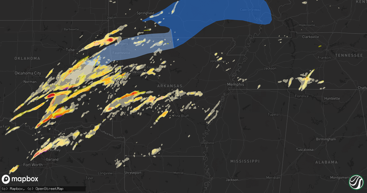
Hail Map in Arkansas on March 14, 2024
Get this storm
March 14 map
$229
one time, instant access
Download today. No call, no setup
Keep the $229
Bought the map and want the full workflow? Apply the entire $229 to a subscription within 7 days. None of it is wasted.
Every map, not just this one
This buys you this map. Subscription and you get every map we run, in the markets you choose from a few cities to whole states to nationwide. Plus real-time alerts the moment a storm fires.
Contact data
Name, contact info, occupancy, even credit band for addresses in the footprint. You go from where it hit to who to call.
Become the source they trust
Unlimited branding weather history reports on demand. You already have the documented answer ready for the property owner, and you are the one who showed up with it.
Property data and RoofTrace estimates
Pull up any address you have got, its value and the exact code rules for that jurisdiction, straight from One Click Code. Then RoofTrace estimates the squares, pitch, and roof value, priced the way you price.
Storm reports in Arkansas
Arkansas
| Date | Description |
|---|---|
| 03/14/20246:51 PM CDT | Report from mping: quarter |
| 03/14/20246:51 PM CDT | Damage to windows and ac units. |
| 03/14/20246:35 PM CDT | A local report indicates 1.50 inch wind near 3 W Tag |
| 03/14/20246:34 PM CDT | Report from mping: ping pong ball |
| 03/14/20246:31 PM CDT | A local report indicates 3.00 inch wind near Gravelly |
| 03/14/20246:30 PM CDT | A local report indicates 1.00 inch wind near Van Buren |
| 03/14/20246:18 PM CDT | A local report indicates 1.75 inch wind near 3 NNE Cedar Creek |
| 03/14/20246:14 PM CDT | Power poles broken. |
| 03/14/20245:40 PM CDT | A local report indicates 1.75 inch wind near Y City |
| 03/14/20245:27 PM CDT | Report from mping: quarter |
| 03/14/20245:25 PM CDT | A local report indicates 1.00 inch wind near Mountainburg |
| 03/14/20245:25 PM CDT | A local report indicates 1.00 inch wind near Fort Smith |
| 03/14/20245:10 PM CDT | Report from mping: quarter |
| 03/14/20245:05 PM CDT | Tree limbs broken and shingles blown off a roof. |
| 03/14/20244:55 PM CDT | Large tree limbs were broken. |
| 03/14/20244:15 PM CDT | A few trees were blown down. |
| 03/14/20243:54 PM CDT | Thunderstorm winds estimated to 60 mph damaged tree limbs. |
| 03/14/20243:45 PM CDT | A local report indicates 1.00 inch wind near Elkins |
| 03/14/20243:35 PM CDT | Thunderstorm winds estimated to 65 mph damaged a boat dock at the hickory creek marina on beaver lake. |
| 03/14/20243:30 PM CDT | Large tree down. |
| 03/14/20243:25 PM CDT | Thunderstorm winds estimated to 60 mph damaged trees and tree limbs. |
| 03/14/20242:28 PM CDT | A local report indicates 2.75 inch wind near Gravette |
| 03/14/20242:17 PM CDT | Busted windows in car. Funnel cloud also reported. Report includes information from ham radio operator. |
| 03/14/20242:13 PM CDT | Observed 1/4 mile north of the community center in maysville. |
| 03/13/20249:08 PM CDT | A local report indicates 1.00 inch wind near 2 WNW Shady Grove |
| 03/13/20248:35 PM CDT | A local report indicates 1.50 inch wind near Story |
| 03/13/20248:30 PM CDT | Public reported quarter sized along needham st. |
| 03/13/20248:29 PM CDT | A local report indicates 1.75 inch wind near 1 WSW Prattsville |
| 03/13/20248:28 PM CDT | A local report indicates 1.25 inch wind near Hot Springs Village |
| 03/13/20248:20 PM CDT | Public reported half dollar sized hail in brookland... Ar. |
| 03/13/20248:09 PM CDT | Roof blown off house. |
| 03/13/20248:05 PM CDT | A local report indicates 2.75 inch wind near 1 SE Jessieville |
| 03/13/20248:04 PM CDT | Report from mping: quarter |
| 03/13/20248:01 PM CDT | Public reported quarter sized hail about 10 miles wsw of paragould. |
| 03/13/20247:57 PM CDT | A local report indicates a tornado near 1 N Mountain Valley |
| 03/13/20247:57 PM CDT | Corrects previous tornado report from 1 n mountain valley to include intensity rating of ef-2. |
| 03/13/20247:55 PM CDT | A local report indicates 1.00 inch wind near Lavaca |
| 03/13/20247:18 PM CDT | Report from mping: quarter |
All States Impacted by Hail Map on March 14, 2024
Cities Impacted by Hail Map on March 14, 2024
- Saint Augustine, IL
- Abingdon, IL
- Avon, IL
- Prairie City, IL
- Berwick, IL
- Eureka, KS
- Hamilton, KS
- Virgil, KS
- Gridley, KS
- Madison, KS
- Toronto, KS
- Yates Center, KS
- Burlington, KS
- Le Roy, KS
- Westphalia, KS
- Garnett, KS
- Waverly, KS
- Piqua, KS
- Downs, IL
- Le Roy, IL
- Ellsworth, IL
- Mora, MO
- Smithton, MO
- Florence, MO
- Otterville, MO
- Syracuse, MO
- Fortuna, MO
- Tipton, MO
- Clarksburg, MO
- Saint Anne, IL
- Momence, IL
- Kankakee, IL
- California, MO
- Latham, MO
- Pembroke Township, IL
- Lake Village, IN
- Schneider, IN
- Lowell, IN
- Tower Hill, IL
- Shelbyville, IL
- Lakewood, IL
- Martinsville, IL
- Annapolis, IL
- West York, IL
- West Union, IL
- Jefferson City, MO
- Holts Summit, MO
- Tebbetts, MO
- Indianapolis, IN
- Camby, IN
- Comanche, OK
- Duncan, OK
- Waurika, OK
- Macomb, OK
- Asher, OK
- Maud, OK
- Tecumseh, OK
- Marlow, OK
- Foster, OK
- Henrietta, TX
- Elmore City, OK
- Lindsay, OK
- Maysville, OK
- Pauls Valley, OK
- Ringling, OK
- Loco, OK
- Shawnee, OK
- Prague, OK
- Wetumka, OK
- Weleetka, OK
- Okemah, OK
- Henryetta, OK
- Okmulgee, OK
- Ringgold, TX
- Paris Crossing, IN
- Commiskey, IN
- Deputy, IN
- Madison, IN
- Lexington, IN
- Morris, OK
- Chouteau, OK
- Chamois, MO
- Twelve Mile, IN
- Arthur, IL
- Oblong, IL
- Star City, IN
- Kewanna, IN
- Crothersville, IN
- Brookston, IN
- Jasonville, IN
- Sullivan, IN
- Demotte, IN
- Farmersburg, IN
- Lewis, IN
- Shelburn, IN
- Terre Haute, IN
- Pimento, IN
- Odon, IN
- Newberry, IN
- Elnora, IN
- West Terre Haute, IN
- Sheldon, IL
- Kentland, IN
- Sedalia, MO
- Green Ridge, MO
- Ryan, OK
- Brazil, IN
- Earlsboro, OK
- Seminole, OK
- Cole Camp, MO
- Rosedale, IN
- Wanette, OK
- Herscher, IL
- Bonfield, IL
- Akron, IN
- Macy, IN
- Willow Hill, IL
- Yale, IL
- Clinton, IN
- Riley, IN
- New Goshen, IN
- Wewoka, OK
- Georgetown, IL
- Ridge Farm, IL
- Indianola, IL
- Castle, OK
- Wheatfield, IN
- Rensselaer, IN
- Fair Oaks, IN
- Paris, IL
- Wolcott, IN
- Mooresville, IN
- Monrovia, IN
- Chrisman, IL
- Holdenville, OK
- Freelandville, IN
- Sandborn, IN
- Oaktown, IN
- Bicknell, IN
- Edwardsport, IN
- Sullivan, IL
- Lovington, IL
- Paoli, OK
- Wayne, OK
- Byars, OK
- Francesville, IN
- Winamac, IN
- Byers, TX
- Vincennes, IN
- Plainville, IN
- Earl Park, IN
- Goodland, IN
- Ada, OK
- Aroma Park, IL
- Cook Sta, MO
- Onarga, IL
- Bainbridge, IN
- Roachdale, IN
- Lexington, OK
- Montezuma, IN
- Hillsdale, IN
- Pryor, OK
- Hanover, IN
- Milton, KY
- Nocona, TX
- Terral, OK
- Wynnewood, OK
- Stratford, OK
- Locust Grove, OK
- Boynton, OK
- Salina, OK
- Haskell, OK
- Vevay, IN
- Spavinaw, OK
- Porter, OK
- Taft, OK
- Gore, OK
- Jay, OK
- Vian, OK
- Grove, OK
- Park Hill, OK
- Cookson, OK
- Davis, OK
- Muskogee, OK
- South West City, MO
- Eucha, OK
- Colcord, OK
- Ghent, KY
- Florence, IN
- Warsaw, KY
- Sparta, KY
- Sanders, KY
- Glencoe, KY
- Dry Ridge, KY
- Carrollton, KY
- Sulphur, OK
- Anderson, MO
- Verona, KY
- Roff, OK
- Crittenden, KY
- Williamstown, KY
- Tahlequah, OK
- De Mossville, KY
- Falmouth, KY
- Wagoner, OK
- Gravette, AR
- Maysville, AR
- Sulphur Springs, AR
- Patriot, IN
- Butler, KY
- Foster, KY
- Eufaula, OK
- Checotah, OK
- Noel, MO
- Brooksville, KY
- Oktaha, OK
- Bella Vista, AR
- Hiwasse, AR
- Pineville, MO
- West Jefferson, OH
- London, OH
- Plain City, OH
- Hilliard, OH
- Dublin, OH
- Amlin, OH
- Galloway, OH
- Columbus, OH
- Lewis Center, OH
- Westerville, OH
- Galena, OH
- Powell, OH
- New Albany, OH
- Fort Gibson, OK
- Hulbert, OK
- Augusta, KY
- Germantown, KY
- Welling, OK
- Proctor, OK
- Mayslick, KY
- Mount Olivet, KY
- Maysville, KY
- Dover, KY
- Braggs, OK
- Bunch, OK
- Westville, OK
- Stilwell, OK
- Kansas, OK
- Watts, OK
- Stigler, OK
- Mokane, MO
- Steedman, MO
- Centralia, MO
- Sturgeon, MO
- Decatur, AR
- Gentry, AR
- Summers, AR
- Siloam Springs, AR
- Harrisburg, MO
- Fayetteville, AR
- Canehill, AR
- Lincoln, AR
- Evansville, AR
- Thompson, MO
- Mexico, MO
- Portland, MO
- Rhineland, MO
- Hermann, MO
- Springdale, AR
- Bentonville, AR
- Winslow, AR
- Prairie Grove, AR
- Farmington, AR
- West Fork, AR
- Morrow, AR
- Tollesboro, KY
- Rogers, AR
- Cave Springs, AR
- Lowell, AR
- Pea Ridge, AR
- Centerton, AR
- Bunceton, MO
- Pilot Grove, MO
- Berryville, AR
- Prairie Home, MO
- Boonville, MO
- Green Forest, AR
- Warrenton, MO
- Marthasville, MO
- Jonesburg, MO
- Goodman, MO
- Sullivan, MO
- Lonedell, MO
- Richwoods, MO
- Bourbon, MO
- Luebbering, MO
- Grubville, MO
- Dittmer, MO
- Elkins, AR
- Garfield, AR
- Laddonia, MO
- Rush Hill, MO
- Farber, MO
- Curryville, MO
- Vandalia, MO
- Porum, OK
- Middletown, MO
- Bowling Green, MO
- Mill Creek, OK
- Tishomingo, OK
- Pittsfield, IL
- Pearl, IL
- Winchester, IL
- Wallingford, KY
- Vanceburg, KY
- Hillsboro, MO
- Stonewall, OK
- Truesdale, MO
- Wright City, MO
- Foristell, MO
- Wentzville, MO
- Clever, MO
- Nixa, MO
- Ozark, MO
- Sparta, MO
- Montgomery City, MO
- Rogersville, MO
- New Florence, MO
- Fordland, MO
- Bruner, MO
- Wooldridge, MO
- Jamestown, MO
- Columbia, MO
- Oldfield, MO
- Seymour, MO
- Ava, MO
- Squires, MO
- Mansfield, MO
- Ashland, MO
- Clarksville, MO
- Sallisaw, OK
- Nebo, IL
- Eolia, MO
- Lake Saint Louis, MO
- O'Fallon, MO
- Pevely, MO
- Barnhart, MO
- Festus, MO
- Herculaneum, MO
- Webbers Falls, OK
- Waterloo, IL
- Smithton, IL
- New Athens, IL
- Tupelo, OK
- Golden Eagle, IL
- Saint Charles, MO
- Saint Peters, MO
- Drury, MO
- Norwood, MO
- Macomb, MO
- Mountain Grove, MO
- Marshfield, MO
- Hartville, MO
- Oak Grove, AR
- Lead Hill, AR
- Alpena, AR
- Omaha, AR
- Wesley, AR
- Eureka Springs, AR
- Hindsville, AR
- Huntsville, AR
- Lampe, MO
- Cedarcreek, MO
- Eagle Rock, MO
- Golden, MO
- Branson, MO
- Shell Knob, MO
- Hollister, MO
- Ridgedale, MO
- Blue Eye, MO
- Kirbyville, MO
- Marble Falls, AR
- Compton, AR
- Kingston, AR
- Ponca, AR
- Combs, AR
- Witter, AR
- Jasper, AR
- Harrison, AR
- Reeds Spring, MO
- Olive Hill, KY
- Emerson, KY
- Rockaway Beach, MO
- Grayson, KY
- Fulton, MO
- High Hill, MO
- Bellflower, MO
- Truxton, MO
- Hawk Point, MO
- Troy, MO
- Elsberry, MO
- Annada, MO
- Jacksonville, IL
- Murrayville, IL
- Woodson, IL
- Franklin, IL
- Waverly, IL
- Virden, IL
- Granite City, IL
- Konawa, OK
- Edwardsville, IL
- Williamsburg, MO
- Collinsville, IL
- Glen Carbon, IL
- Maryville, IL
- Troy, IL
- Valmeyer, IL
- Fults, IL
- Lynchburg, MO
- Grovespring, MO
- Graff, MO
- Plato, MO
- Huggins, MO
- Cabool, MO
- Houston, MO
- Vanzant, MO
- Solo, MO
- Bucyrus, MO
- Willow Springs, MO
- Elk Creek, MO
- Dora, MO
- Yellville, AR
- Theodosia, MO
- Rueter, MO
- Isabella, MO
- Protem, MO
- Kissee Mills, MO
- Peel, AR
- Oakland, AR
- Everton, AR
- Western Grove, AR
- Pyatt, AR
- Marine, IL
- Keota, OK
- La Fontaine, IN
- Bunker Hill, IN
- Marion, IN
- Miami, IN
- Highland, IL
- Amboy, IN
- Van Buren, IN
- Aviston, IL
- Warren, IN
- Montpelier, IN
- Trenton, IL
- Converse, IN
- Peru, IN
- Gans, OK
- Muldrow, OK
- Portage Des Sioux, MO
- Red Bud, IL
- Florissant, MO
- Hecker, IL
- Freeburg, IL
- Kinta, OK
- Auburn, IL
- Divernon, IL
- Pawnee, IL
- Thayer, IL
- Mascoutah, IL
- Belleville, IL
- Lenzburg, IL
- Mccurtain, OK
- Poneto, IN
- Liberty Center, IN
- Bluffton, IN
- Lebanon, IL
- Morrisonville, IL
- Potosi, MO
- Carrollton, IL
- Summerfield, IL
- Kane, IL
- Eldred, IL
- Centrahoma, OK
- Rockbridge, IL
- Saint James, MO
- Steelville, MO
- Coalgate, OK
- Greenfield, IL
- Frankfort, IN
- Colfax, IN
- Chesterfield, IL
- Medora, IL
- Saint Louis, MO
- Michigantown, IN
- Arnold, MO
- Imperial, MO
- East Alton, IL
- Wardville, OK
- South Roxana, IL
- Hartford, IL
- Stuart, OK
- Pocahontas, IL
- Fenton, MO
- Mcalester, OK
- Worden, IL
- Alhambra, IL
- Hamel, IL
- New Douglas, IL
- Livingston, IL
- East Carondelet, IL
- Blackwell, MO
- De Soto, MO
- Fletcher, MO
- Keystone, IN
- Geneva, IN
- Marietta, OK
- Roxana, IL
- Kiowa, OK
- Berne, IN
- Beulah, MO
- Edgar Springs, MO
- Lenox, MO
- Roby, MO
- Salem, MO
- Success, MO
- Licking, MO
- Raymondville, MO
- Jadwin, MO
- Eminence, MO
- Summersville, MO
- Yukon, MO
- Eunice, MO
- Hartshorn, MO
- Birch Tree, MO
- Mountain View, MO
- Caulfield, MO
- Peace Valley, MO
- Pomona, MO
- West Plains, MO
- Moody, MO
- Pottersville, MO
- Bakersfield, MO
- Elizabeth, AR
- Tecumseh, MO
- Gamaliel, AR
- Gepp, AR
- Henderson, AR
- Zanoni, MO
- Brixey, MO
- Bull Shoals, AR
- Gainesville, MO
- Gassville, AR
- Cotter, AR
- Flippin, AR
- Norfork, AR
- Summit, AR
- Lakeview, AR
- Valley Springs, AR
- Pontiac, MO
- Mountain Home, AR
- Saint Joe, AR
- Midway, AR
- Udall, MO
- Clarkridge, AR
- Calico Rock, AR
- Wasola, MO
- Hardenville, MO
- Thornfield, MO
- Prairie Du Rocher, IL
- Kempton, IN
- Forest, IN
- Russiaville, IN
- Tipton, IN
- Sharpsville, IN
- Taylorville, IL
- Bulpitt, IL
- Kincaid, IL
- Edinburg, IL
- Tovey, IL
- Goldsmith, IN
- Assumption, IL
- Stonington, IL
- Hettick, IL
- Carlinville, IL
- Rudy, AR
- Mountainburg, AR
- Columbia, IL
- Chester, AR
- Fort Smith, AR
- Barling, AR
- Lavaca, AR
- Alma, AR
- Van Buren, AR
- Dupo, IL
- Petroleum, IN
- Gillespie, IL
- Gainesville, TX
- Bokoshe, OK
- Spiro, OK
- Marissa, IL
- Addieville, IL
- Saint Libory, IL
- Litchfield, IL
- Shipman, IL
- O'Fallon, IL
- Haslet, TX
- Madill, OK
- Fort Worth, TX
- Rockford, OH
- Celina, OH
- Mendon, OH
- Hartford City, IN
- Cameron, OK
- Wabash, IN
- Inola, OK
- Wellsville, MO
- Fieldon, IL
- Kokomo, IN
- Ossian, IN
- Decatur, IN
- South Greenfield, MO
- Galveston, IN
- Walton, IN
- Markle, IN
- Walnut Shade, MO
- Dustin, OK
- Peebles, OH
- Brussels, IL
- Afton, OK
- Vinita, OK
- Thorntown, IN
- Darlington, IN
- Bradleyville, MO
- Healdton, OK
- Graham, OK
- Ratliff City, OK
- Springer, OK
- Scottsburg, IN
- Austin, IN
- Flemingsburg, KY
- Dupont, IN
- New Berlin, IL
- Scott Air Force Base, IL
- East Saint Louis, IL
- Greentown, IN
- Poteau, OK
- Huntington, IN
- Ladoga, IN
- Chelsea, OK
- Talala, OK
- Oologah, OK
- Sasakwa, OK
- Adair, OK
- Lebanon, IN
- Kirklin, IN
- Rose, OK
- Crystal City, MO
- Schell City, MO
- Monett, MO
- Purdy, MO
- Pierce City, MO
- Canadian, OK
- Hanna, OK
- Bryant, IN
- Pennville, IN
- Eldridge, MO
- Lebanon, MO
- Stoutland, MO
- Depew, OK
- Bristow, OK
- Ozark, AR
- Lamar, MO
- Auxvasse, MO
- Kingdom City, MO
- Broken Arrow, OK
- Strang, OK
- McCune, KS
- Cedarville, AR
- Aurora, MO
- Saint Jacob, IL
- Smithville, OK
- Heavener, OK
- Boles, AR
- Mena, AR
- West Alton, MO
- Powell, MO
- Washburn, MO
- Rocky Comfort, MO
- Forsyth, MO
- Taneyville, MO
- Venice, IL
- Caseyville, IL
- Lovejoy, IL
- Madison, IL
- Crawfordsville, IN
- New Bloomfield, MO
- Council Hill, OK
- Fitzhugh, OK
- Tunas, MO
- Buffalo, MO
- Milburn, OK
- White Hall, IL
- Kampsville, IL
- Liberal, MO
- Mindenmines, MO
- Windfall, IN
- Lanagan, MO
- Stella, MO
- Montreal, MO
- Mount Judea, AR
- Vendor, AR
- Galena, MO
- Kimberling City, MO
- Lagro, IN
- Bethany, IL
- Paden, OK
- Milton, IL
- Wood River, IL
- Rockville, MO
- Garrison, MO
- Chadwick, MO
- New Baden, IL
- Germantown, IL
- Bartelso, IL
- Carlyle, IL
- Albers, IL
- Camdenton, MO
- Billings, MO
- Natural Dam, AR
- Broken Bow, OK
- Ionia, MO
- Warner, OK
- Walnut, KS
- Saint Paul, KS
- Girard, KS
- Seligman, MO
- Fairview, MO
- Neosho, MO
- Stark City, MO
- Highlandville, MO
- La Russell, MO
- Chatham, IL
- Roanoke, TX
- Beggs, OK
- Indianola, OK
- Bowlegs, OK
- Uniontown, AR
- Whitefield, OK
- Swayzee, IN
- Jonesboro, IN
- Fairmount, IN
- Savanna, OK
- Butler, IL
- Moweaqua, IL
- Hillsboro, IL
- Argyle, TX
- Irving, IL
- Witt, IL
- Keller, TX
- Fort Jennings, OH
- Ottoville, OH
- Flower Mound, TX
- Krebs, OK
- Charleston, AR
- Findlay, IL
- Calvin, OK
- Saint Marys, OH
- Gas City, IN
- Mulberry, AR
- Windsor, IL
- Gays, IL
- Jamestown, IN
- Allen, OK
- Mattoon, IL
- Charleston, IL
- Sheridan, IN
- Atlanta, IN
- Nokomis, IL
- Fillmore, IL
- Arcadia, IN
- Denton, TX
- Waldron, AR
- Parks, AR
- Lewisville, TX
- Harvey, AR
- Hartshorne, OK
- Strasburg, IL
- Lamar, OK
- Ashmore, IL
- Findlay, OH
- Atwood, OK
- Coleman, OK
- Wapanucka, OK
- Caddo Gap, AR
- Norman, AR
- Lake Dallas, TX
- Little Elm, TX
- Aubrey, TX
- Fostoria, OH
- Arcadia, OH
- Alvada, OH
- Wapakoneta, OH
- New Riegel, OH
- Carey, OH
- Tiffin, OH
- Uniopolis, OH
- Whitestown, IN
- Zionsville, IN
- Dover, AR
- Pelsor, AR
- Carmel, IN
- Westfield, IN
- Noblesville, IN
- Gravelly, AR
- Bluffton, AR
- Bloomville, OH
- Republic, OH
- Attica, OH
- Summitville, IN
- Alexandria, IN
- Gaston, IN
- Muncie, IN
- Yorktown, IN
- Albany, IN
- Eaton, IN
- Wilburton, OK
- Watson, OK
- Fishers, IN
- Red Oak, OK
- Quinton, OK
- Cove, AR
- Hatfield, AR
- Lakeview, OH
- Frisco, TX
- Sycamore, OH
- New Bremen, OH
- New Knoxville, OH
- Botkins, OH
- Jackson Center, OH
- Lewistown, OH
- Belle Center, OH
- Huntsville, OH
- Prosper, TX
- Celina, TX
- Hamilton, MS
- Farmland, IN
- Parker City, IN
- Winchester, IN
- Ridgeville, IN
- Aberdeen, MS
- Pendleton, IN
- Greenwood Springs, MS
- Amory, MS
- Advance, IN
- New Washington, OH
- Atoka, OK
- Smithville, MS
- Willard, OH
- Hamilton, AL
- Tremont, MS
- Fulton, MS
- Briggsville, AR
- Danville, AR
- Russells Point, OH
- Bingham, IL
- Bonnerdale, AR
- Mount Ida, AR
- Plymouth, OH
- Shelby, OH
- Tiro, OH
- Markleville, IN
- Crowder, OK
- Millstadt, IL
- Coulterville, IL
- Oakdale, IL
- Mckinney, TX
- Nashville, IL
- Ashley, IL
- Plainview, AR
- Vina, AL
- Golden, MS
- Red Bay, AL
- Anna, TX
- New Castle, IN
- Shirley, IN
- Middletown, IN
- Kenefic, OK
- Shiloh, OH
- Greenwich, OH
- Leadwood, MO
- Irondale, MO
- Mineral Point, MO
- Davisville, MO
- Bonne Terre, MO
- Valles Mines, MO
- Cherryville, MO
- Belgrade, MO
- Bismarck, MO
- Park Hills, MO
- Cadet, MO
- Boss, MO
- Belleview, MO
- Bixby, MO
- Centerville, MO
- Viburnum, MO
- Ellington, MO
- Caledonia, MO
- French Village, MO
- Black, MO
- Bunker, MO
- Piedmont, MO
- Koshkonong, MO
- Redford, MO
- Fremont, MO
- Annapolis, MO
- Middle Brook, MO
- Van Buren, MO
- Pilot Knob, MO
- Lesterville, MO
- Alton, MO
- Arcadia, MO
- Vulcan, MO
- Ironton, MO
- Farmington, MO
- Winona, MO
- Doe Run, MO
- Bexar, AR
- Couch, MO
- Thayer, MO
- Viola, AR
- Camp, AR
- Mammoth Spring, AR
- Sturkie, AR
- Brandsville, MO
- Dolph, AR
- Salem, AR
- Raymond, OH
- West Mansfield, OH
- Marysville, OH
- Broadway, OH
- Ridgeway, OH
- Rushsylvania, OH
- Bellefontaine, OH
- Zanesfield, OH
- East Liberty, OH
- Oakland, IL
- Richwood, OH
- Oden, AR
- Trilla, IL
- Lerna, IL
- Van Alstyne, TX
- Staunton, IL
- Sorento, IL
- Jessieville, AR
- Mountain Pine, AR
- Hot Springs Village, AR
- Walshville, IL
- Panama, IL
- Donnellson, IL
- Hagerstown, IN
- Mooreland, IN
- Losantville, IN
- Coffeen, IL
- Union City, IN
- Saratoga, IN
- Ostrander, OH
- Magnetic Springs, OH
- Radnor, OH
- Belmont, MS
- Raymond, IL
- Rosamond, IL
- Pana, IL
- Oconee, IL
- Ramsey, IL
- Delaware, OH
- Caddo, OK
- Caney, OK
- Economy, IN
- Williamsburg, IN
- Modoc, IN
- Pencil Bluff, AR
- Greenville, IL
- Mulberry Grove, IL
- Smithboro, IL
- Vandalia, IL
- Richview, IL
- Hoyleton, IL
- Pocola, OK
- Woodlawn, IL
- Mount Vernon, IL
- Opdyke, IL
- Bluford, IL
- Belle Rive, IL
- Keenes, IL
- Wayne City, IL
- Sims, IL
- Fairfield, IL
- Beaver Falls, PA
- Rochester, PA
- Fombell, PA
- New Brighton, PA
- Zelienople, PA
- Harmony, PA
- Evans City, PA
- Renfrew, PA
- Connoquenessing, PA
- Butler, PA
- Beaver, PA
- Whitewright, TX
- Bono, AR
- Paragould, AR
- Sunbury, OH
- Tioga, TX
- Howe, TX
- Gunter, TX
- Blue Ridge, TX
- Leonard, TX
- Trenton, TX
- Stringtown, OK
- Lane, OK
- Thornville, OH
- Jacksontown, OH
- Heath, OH
- Hebron, OH
- Lonsdale, AR
- Paron, AR
- Benton, AR
- Glenford, OH
- Mount Perry, OH
- Hopewell, OH
- Nashport, OH
- Alexander, AR
- Little Rock, AR
- Croton, OH
- Centerburg, OH
- Johnstown, OH
- Utica, OH
- Newark, OH
- Alexandria, OH
- Granville, OH
- Saint Louisville, OH
- Zanesville, OH
- Frazeysburg, OH
- Dresden, OH
- Sims, AR
- Arkadelphia, AR
- Leola, AR
- Malvern, AR
- Westpoint, TN
- Iron City, TN
- Lawrenceburg, TN
- Loretto, TN
- Randolph, TX
- Bonham, TX
- Prattsville, AR
- Poyen, AR
- Patoka, IN
- Princeton, IN
- Saint Paris, OH
- Urbana, OH
- Celeste, TX
- Klondike, TX
- Cooper, TX
- Francisco, IN
- Roland, AR
- Patterson, MO
- Mill Spring, MO
- Ellsinore, MO
- Des Arc, MO
- Fredericktown, MO
- Silva, MO
- Patton, MO
- Marquand, MO
- Lodi, MO
- Sainte Genevieve, MO
- Marble Hill, MO
- Greenville, MO
- Clubb, MO
- Glenallen, MO
- Wappapello, MO
- Williamsville, MO
- Grandin, MO
- Oran, MO
- Chaffee, MO
- Brownwood, MO
- Whitewater, MO
- Bloomsdale, MO
- Zalma, MO
- Leopold, MO
- McGee, MO
- Lowndes, MO
- Sturdivant, MO
- Gipsy, MO
- Advance, MO
- Perryville, MO
- Bloomfield, MO
- Puxico, MO
- Bell City, MO
- Scott City, MO
- Bertrand, MO
- Friedheim, MO
- Jackson, MO
- Oak Ridge, MO
- Cape Girardeau, MO
- Vanduser, MO
- Sikeston, MO
- Millersville, MO
- Benton, MO
- Charleston, MO
- Daisy, MO
- Burfordville, MO
- Sedgewickville, MO
- Saint Mary, MO
- Ava, IL
- Cobden, IL
- Jacob, IL
- Chester, IL
- Cairo, IL
- McClure, IL
- Altenburg, MO
- Rockwood, IL
- Villa Ridge, IL
- Mounds, IL
- Miller City, IL
- Anna, IL
- Uniontown, MO
- Old Appleton, MO
- Ullin, IL
- Jonesboro, IL
- Wolf Lake, IL
- Pomona, IL
- Carbondale, IL
- Alto Pass, IL
- Makanda, IL
- Gorham, IL
- Frohna, MO
- Olive Branch, IL
- Pulaski, IL
- Murphysboro, IL
- Grand Tower, IL
- Tamms, IL
- Dongola, IL
- Thebes, IL
- Farrar, MO
- Campbell Hill, IL
- Steeleville, IL
- Ellis Grove, IL
- Modoc, IL
- Grantsburg, IL
- Belknap, IL
- Karnak, IL
- Kevil, KY
- Bardwell, KY
- Metropolis, IL
- Grand Chain, IL
- La Center, KY
- Buncombe, IL
- Goreville, IL
- Barlow, KY
- Paducah, KY
- Mound City, IL
- Vienna, IL
- Cypress, IL
- Melber, KY
- West Paducah, KY
- Cunningham, KY
- Wickliffe, KY
- Olmsted, IL
- Florence, AL
- Jonesboro, AR
- Brookland, AR
- Brookston, TX
- Sumner, TX
- Wolfe City, TX
- Summertown, TN
- Ethridge, TN
- Mount Pleasant, TN
- Mount Carmel, IL
- Allendale, IL
- Decker, IN
- Sumner, IL
- Saint Francisville, IL
- Hazleton, IN
- Monroe City, IN
- Petersburg, IN
- Loogootee, IN
- Cannelburg, IN
- Shoals, IN
- Bedford, KY
- Ashland City, TN
- English, IN
- Marengo, IN
- Palmyra, IN
- Pattonville, TX
- Paris, TX
- Blossom, TX
- Deport, TX
- Detroit, TX
- Pekin, IN
- Borden, IN
- Greenville, IN
- Clarksville, TX
- Russellville, AL
- Union City, OH
- Portland, IN
- Arcanum, OH
- New Madison, OH
- Chesterfield, MO
- Reelsville, IN
- Carbon, IN
- Cloverdale, IN
- Greencastle, IN
- Flora, IL
- Silex, MO
- Westfield, IL
- Casey, IL
- Story, AR
- Girard, IL
- Palmyra, IL
- Columbus Grove, OH
- Pandora, OH
- Rawson, OH
- Ottawa, OH
- Bluffton, OH
- Mount Cory, OH
- Hillsboro, IN
- Anderson, IN
- Alamo, IN
- Lapel, IN
- Fortville, IN
- New Ross, IN
- Waynetown, IN
- Vermilion, IL
- Berger, MO
- Savannah, TN
- Olivehill, TN
- Murray, KY
- Hazel, KY
- Sulligent, AL
- Nettleton, MS
- Columbus, MS
- Detroit, AL
- West Point, MS
- Selma, IN
- Frankton, IN
- Elwood, IN
- Dunkirk, IN
- Upland, IN
- Pilot Point, TX
- Clinton, AR
- Dennard, AR
- Batchtown, IL
- Cory, IN
- Bagwell, TX
- Mansfield, AR
- Piqua, OH
- Sparkman, AR
- Carthage, AR
- Fillmore, IN
- Versailles, MO
- Barnett, MO
- Russellville, MO
- Warsaw, OH
- Gurdon, AR
- McComb, OH
- Marshall, IN
- Rockville, IN
- House Springs, MO
- Bonnie, IL
- Ina, IL
- Campbell, TX
- Commerce, TX
- Cumby, TX
- Defiance, MO
- Augusta, MO
- Worthington, IN
- Switz City, IN
- Versailles, OH
- Greenville, OH
- Bradford, OH
- Norris City, IL
- Carmi, IL
- New Harmony, IN
- Enfield, IL
- Wadesville, IN
- New Haven, IL
- Mount Vernon, IN
- Hackett, AR
- Greenwood, AR
- Uniondale, IN
- Clayton, OK
- Centerpoint, IN
- Merom, IN
- Bridgeport, IL
- Flat Rock, IL
- Lawrenceville, IL
- Claremont, IL
- Olney, IL
- Okawville, IL
- Centertown, MO
- Poseyville, IN
- Evansville, IN
- Haubstadt, IN
- Batavia, OH
- Centralia, IL
- Pittsburg, OK
- Blanco, OK
- Lamar, AR
- Ardmore, OK
- Mannsville, OK
- Daisy, OK
- Hagarville, AR
- Carlisle, IN
- Palestine, IL
- Ansonia, OH
- Loami, IL
- Robertsville, MO
- Moscow Mills, MO
- Old Monroe, MO
- Hot Springs National Park, AR
- Maumelle, AR
- Griffin, IN
- Owensville, IN
- Antlers, OK
- Finley, OK
- Rattan, OK
- Collinwood, TN
- Lyons, IN
- Bloomfield, IN
- Scotland, IN
- Royal, AR
- Glenwood, AR
- Otisco, IN
- Marysville, IN
- Harrisburg, AR
- Bethel, OK
- Scranton, AR
- New Blaine, AR
- Washington, IN
- Hardinsburg, KY
- Roann, IN
- Booneville, AR
- Magazine, AR
- Stilesville, IN
- Coatesville, IN
- Parkersburg, IL
- Calhoun, IL
- New Paris, OH
- Fountain City, IN
- Richmond, IN
- Eldorado, OH
- Port Washington, OH
- Newcomerstown, OH
- Maryland Heights, MO
- Huntington, AR
- Eckerty, IN
- Taswell, IN
- Kingston, OK
- Hodgen, OK
- Fayetteville, OH
- Grand Junction, TN
- Upper Sandusky, OH
- Mount Orab, OH
- Goshen, OH
- Hillsboro, OH
- Williamsburg, OH
- Blanchester, OH
- Lynchburg, OH
- Marshall, AR
- Labadie, MO
- Leslie, AR
- Freeburg, MO
- Cypress Inn, TN
- Hampshire, TN
- London, AR
- Russellville, AR
- Eagletown, OK
- Clarksville, AR
- Oark, AR
- Waveland, IN
- Anna, OH
- Minster, OH
- Winslow, IN
- Ector, TX
- Springville, IN
- Miller, MO
- Middle Point, OH
- Van Wert, OH
- Hector, AR
- Alexander, IL
- Pleasant Plains, IL
- Ozone, AR
- Industry, PA
- Darlington, PA
- Justin, TX
- Muenster, TX
- Logansport, IN
- New Waverly, IN
- Jerusalem, AR
- Seymour, IN
- Marshall, IL
- Sheridan, AR
- Caldwell, OH
- Bloomington, IN
- Dennison, IL
- Mason, IL
- Louisville, IL
- Edgewood, IL
- Farina, IL
- Wheatland, IN
- North Salem, IN
- Danville, IN
- Greenfield, IN
- Mccordsville, IN
- Wheaton, MO
- Hartman, AR
- West Salem, IL
- Maplewood, OH
- Sidney, OH
- Roodhouse, IL
- Manila, AR
- Neoga, IL
- Mount Vernon, OH
- Hardin, IL
- Harned, KY
- Maria Stein, OH
- Saint Henry, OH
- Tuskahoma, OK
- Blue Mound, IL
- Kinmundy, IL
- Shobonier, IL
- Vernon, IL
- Alma, IL
- Patoka, IL
- Howe, OK
- Dix, IL
- Xenia, IL
- Pleasant Plain, OH
- Midland, OH
- Montgomery, IN
- Perryville, AR
- Mount Erie, IL
- Cisne, IL
- Waynesfield, OH
- De Graff, OH
- Quincy, OH
- Dodd City, TX
- Princeton, TX
- Bailey, TX
- Melissa, TX
- Bells, TX
- Savoy, TX
- Tom Bean, TX
- Sherman, TX
- Golden Gate, IL
- High Ridge, MO
- Cedar Hill, MO
- Thackerville, OK
- Saint Peter, IL
- Branch, AR
- Bethalto, IL
- Cumberland, OH
- Powersite, MO
- Daleville, MS
- Lauderdale, MS
- Dieterich, IL
- Nashoba, OK
- Arkoma, OK
- Shady Point, OK
- Albion, IL
- Avon, IN
- Brownsburg, IN
- Noble, IL
- Clay City, IL
- Ingraham, IL
- De Kalb, MS
- Meridian, MS
- Bailey, MS
- Paris, TN
- Crestwood, KY
- Smithfield, KY
- Fort Recovery, OH
- Coldwater, OH
- Atkins, AR
- Johnsonville, IL
- Walnut Hill, IL
- Texico, IL
- Iuka, IL
- Irvington, IL
- Kell, IL
- Keyesport, IL
- Hartford, AR
- North Little Rock, AR
- Whitesboro, TX
- Big Cabin, OK
- Marked Tree, AR
- Lepanto, AR
- Dyess, AR
- Grafton, IL
- Langley, AR
- Wickes, AR
- Cecil, AR
- Waynesboro, TN
- Selmer, TN
- Adamsville, TN
- Stantonville, TN
- Newton, IL
- Hohenwald, TN
- Shirley, AR
- Linton, IN
- Crossville, IL
- Grayville, IL
- Jeffersonville, IN
- Louisville, KY
- Haileyville, OK
- Coshocton, OH
- Clay City, IN
- Bowling Green, IN
- Ewing, IL
- Stewardson, IL
- Baldwin, IL
- Modesto, IL
- Rinard, IL
- Eureka, MO
- Glenarm, IL
- Waltonville, IL
- Rushville, OH
- Somerset, OH
- Chandlersville, OH
- New Lexington, OH
- Roseville, OH
- Cottage Grove, TN
- Puryear, TN
- Bellevue, TX
- Everton, MO
- Conesville, OH
- Pittsboro, IN
- Lizton, IN
- Scotland, AR
- Ratcliff, AR
- Wister, OK
- Roland, OK
- Paris, AR
- Altus, AR
- Pettigrew, AR
- Dyer, AR
- Fletcher, OH
- Conover, OH
- Washington, MO
- Moscow, TN
- Hickory Valley, TN
- La Grange, TN
- Caraway, AR
- Sandoval, IL
- Benton, IL
- Macedonia, IL
- Stover, MO
- State University, AR
- New Haven, MO
- Crooksville, OH
- New Washington, IN
- Nabb, IN
- Tippecanoe, OH
- Gnadenhutten, OH
- Uhrichsville, OH
- Kimbolton, OH
- Paoli, IN
- Hardinsburg, IN
- Bone Gap, IL
- Fairview Heights, IL
- Morris Chapel, TN
- Crump, TN
- Breese, IL
- Salem, IL
- Hoffman, IL
- Beckemeyer, IL
- Odin, IL
- Willshire, OH
- New Hampshire, OH
- Grissom Arb, IN
- New Market, IN
- Kingman, IN
- Veedersburg, IN
- Ingalls, IN
- Mount Sterling, MO
- Morrison, MO
- Linn, MO
- Clifton, TN
- Hasty, AR
- Pindall, AR
- Millersport, OH
- Pickerington, OH
- Buckeye Lake, OH
- Carroll, OH
- Canal Winchester, OH
- Baltimore, OH
- Grannis, AR
- Garvin, OK
- Palmer, IL
- Rives, TN
- Idabel, OK
- Mount Hope, AL
- Town Creek, AL
- Moulton, AL
- Trinity, AL
- Hillsboro, AL
- Decatur, AL
- Pulaski, TN
- Tanner, AL
- Ballinger, TX
- Talpa, TX
- Valera, TX
- Coleman, TX
- Bangs, TX
- Santa Anna, TX
- Santo, TX
- Lipan, TX
- Weatherford, TX
- Millsap, TX
- Granbury, TX
- Joelton, TN
- Millington, TN
- Ivanhoe, TX
- Ravenna, TX
- Helena, AR
- Lexa, AR
- West Helena, AR
- Cabot, AR
- Jacksonville, AR
- Milltown, IN
- Lewisville, AR
- Rossville, IN
- Ardmore, AL
- Elkmont, AL
- Athens, AL
- Toney, AL
- Turners Station, KY
- New Liberty, KY
- Worthville, KY
- Amity, AR
- Otwell, IN
- Rowena, TX
- Norton, TX
- Chillicothe, OH
- Pecan Gap, TX
- New Castle, KY
- Campbellsburg, KY
- Grapevine, AR
- White Hall, AR
- Butlerville, IN
- Horse Branch, KY
- Honey Grove, TX
- Windom, TX
- Roxton, TX
- Petty, TX
- Clarksdale, MS
- Crumrod, AR
- Alligator, MS
- Stuttgart, AR
- Saint Charles, AR
- Holly Grove, AR
- Marvell, AR
- Mead, OK
- Valley View, TX
- Calhoun, KY
- Utica, KY
- Smackover, AR
- Ranger, TX
- Eastland, TX
- Magnolia, AR
- Junction City, AR
- Emerson, AR
- El Dorado, AR
- Stevenson, AL
- Clarendon, AR
- Biscoe, AR
- Des Arc, AR
- Brinkley, AR
- Jonesville, KY
- Owenton, KY
- Prospect, TN
- Valliant, OK
- Jefferson, TX
- Karnack, TX
- Lonoke, AR
- Ladonia, TX
- Altheimer, AR
- Sherrill, AR
- Sherwood, AR
- Pottsboro, TX
- Austin, AR
- Conway, AR
- Almyra, AR
- Spruce Pine, AL
- Hazen, AR
- Carlisle, AR
- Princeton, AL
- Hartsburg, MO
- Kingston, OH
- Laurelville, OH
- Hattieville, AR
- Cleveland, AR
- Cynthiana, KY
- Berry, KY
- Manitou, KY
- Hanson, KY
- Dixon, KY
- Slaughters, KY
- Leighton, AL
- Lake City, AR
- Leitchfield, KY
- Scott, AR
- Little Rock Air Force Base, AR
- Kirby, AR
- Dierks, AR
- Umpire, AR
- Vine Grove, KY
- Ekron, KY
- Clarks Hill, IN
- Humnoke, AR
- Ulm, AR
- Wabbaseka, AR
- Tucker, AR
- England, AR
- Hopkinsville, KY
- North Vernon, IN
- De Witt, AR
- Arlington, TN
- Talihina, OK
- Mellwood, AR
- Pearcy, AR
- Elaine, AR
- Collinsville, TX
- Tyronza, AR
- Traskwood, AR
- Dundee, MS
- Sledge, MS
- Coahoma, MS
- Sulphur, KY
- Pendleton, KY
- Enloe, TX
- Mabelvale, AR
- Hollytree, AL
- Estillfork, AL
- Scottsboro, AL
- Corinth, KY
- Sadieville, KY
- Cotton Plant, AR
- Lake Creek, TX
- Mountain View, AR
- Fox, AR
- Bauxite, AR
- Salem, IN
- Campbellsburg, IN
- Humphrey, AR
- Memphis, TN
- Rhome, TX
- Perry Park, KY
- Bethlehem, KY
- Lockport, KY
- Newhope, AR
- Herndon, KY
- Honobia, OK
- Irvington, KY
- La Grange, KY
- Shelbyville, KY
- Phil Campbell, AL
- Fackler, AL
- New Market, AL
- Bridgeport, AL
- Gurley, AL
- Huntsville, AL
- Ardmore, TN
- Arthur City, TX
- Ozona, TX
- Dryden, TX
- Eldorado, TX
- Sonora, TX
- Minden, LA
- Christoval, TX
- Taylor, AR
- Marshall, TX
- Shelby, MS
- Duncan, MS
- Gunnison, MS
- Ida, LA
- Hosston, LA
- Vivian, LA
- Rodessa, LA
- Snow Lake, AR
- Stephenville, TX
- Winters, TX
- Oil City, LA
- Haynesville, LA
- Homer, LA
- Athens, LA
- Newark, TX
- Azle, TX
- Loving, NM
- Iraan, TX
- Sheffield, TX
- Monticello, AR
- Merigold, MS
- Lyon, MS
- Mingus, TX
- Leoma, TN
- Doddridge, AR
- Mound Bayou, MS
- Decatur, TX
- Bradley, AR
- Plain Dealing, LA
- Water Valley, MS
- Lovington, NM
- Caledonia, MS
- Gattman, MS
- Ponder, TX
- Shongaloo, LA
- Hazelwood, MO
- Bridgeton, MO
- Pleasureville, KY
- Mount Victory, OH
- La Rue, OH
- Austin, TX
- Catawissa, MO
- Union, MO
- Saint Clair, MO
- Saint Albans, MO
- Villa Ridge, MO
- Del Valle, TX
- Havana, AR
- Pacific, MO
- Adamsville, OH
- South Bloomingville, OH
- Rockbridge, OH
- Logan, OH
- Jerseyville, IL
- Brighton, IL
- Fidelity, IL
- Webster, KY
- New Albany, MS
- Steens, MS
- Belvidere, TN


