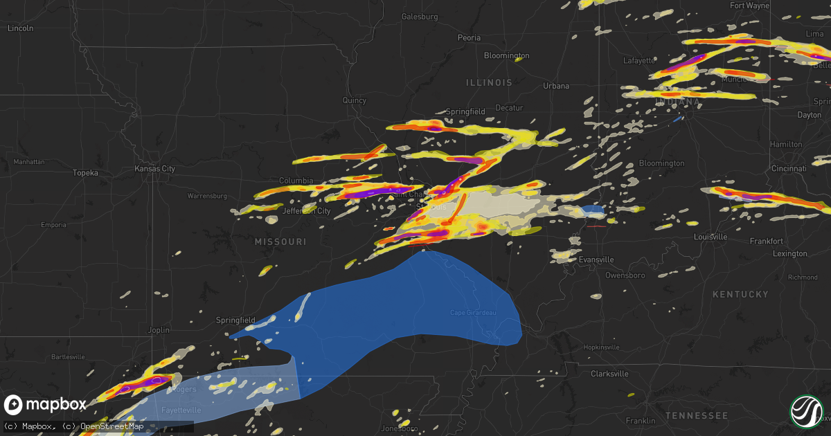
Hail Map on March 14, 2024
Get this storm
March 14 map
$229
one time, instant access
Download today. No call, no setup
Keep the $229
Bought the map and want the full workflow? Apply the entire $229 to a subscription within 7 days. None of it is wasted.
Every map, not just this one
This buys you this map. Subscription and you get every map we run, in the markets you choose from a few cities to whole states to nationwide. Plus real-time alerts the moment a storm fires.
Contact data
Name, contact info, occupancy, even credit band for addresses in the footprint. You go from where it hit to who to call.
Become the source they trust
Unlimited branding weather history reports on demand. You already have the documented answer ready for the property owner, and you are the one who showed up with it.
Property data and RoofTrace estimates
Pull up any address you have got, its value and the exact code rules for that jurisdiction, straight from One Click Code. Then RoofTrace estimates the squares, pitch, and roof value, priced the way you price.
States Impacted by Hail Map on March 14, 2024
Storm reports
Indiana
| Date | Description |
|---|---|
| 03/14/20246:57 PM CDT | Relayed via social media... Time estimated from radar. |
| 03/14/20246:44 PM CDT | Time estimated from radar. |
| 03/14/20246:39 PM CDT | Damage to homes and trees. Possible tornado. Time estimated from radar. |
| 03/14/20246:39 PM CDT | Reports 1.00 inch hail across montgomery county from ema and at i-74 and sr-32. |
| 03/14/20246:37 PM CDT | *** 38 inj *** ef-3 tornado with maximum winds of 165 mph tracked from west of selma into ohio with a path length of 25.03 miles and maximum width of 700 yards. |
| 03/14/20246:37 PM CDT | Time estimated from radar. |
| 03/14/20246:35 PM CDT | A local report indicates 1.25 inch wind near Center |
| 03/14/20246:33 PM CDT | Time estimated from radar. |
| 03/14/20246:32 PM CDT | A local report indicates 1.00 inch wind near Clinton |
| 03/14/20246:30 PM CDT | Southwest to south side of westfield reports of 1.00 to 1.25 inch hail. |
| 03/14/20246:30 PM CDT | Dime to quarter hail lasted from 730 to 733 pm at indiana route 32 and ditch road. |
| 03/14/20246:30 PM CDT | A local report indicates 1.00 inch wind near 2 W Trenton |
| 03/14/20246:30 PM CDT | Dime to quarter hail lasted 62 report from mping: quarter . |
| 03/14/20246:28 PM CDT | A local report indicates 1.00 inch wind near 1 NW Atlanta |
| 03/14/20246:28 PM CDT | Time estimated from radar. |
| 03/14/20246:26 PM CDT | Photo of 2.00 hail 2 miles north of delaware county airport. Time estimated from radar. |
| 03/14/20246:22 PM CDT | Time estimated from radar. |
| 03/14/20246:19 PM CDT | A local report indicates 1.00 inch wind near 4 W Atlanta |
| 03/14/20246:18 PM CDT | A local report indicates 1.75 inch wind near Whitestown |
| 03/14/20246:16 PM CDT | Several large tree limbs snapped. Time estimated from radar. |
| 03/14/20246:12 PM CDT | A local report indicates 2.00 inch wind near Poneto |
| 03/14/20246:08 PM CDT | Report from mping: ping pong ball |
| 03/14/20246:04 PM CDT | A local report indicates 1.00 inch wind near 1 SSE Marion |
| 03/14/20246:01 PM CDT | Thunderstorm winds downed small tree. Time estimated from radar. |
| 03/14/20245:48 PM CDT | Home damage from hail. Time estimated from radar. |
| 03/14/20245:47 PM CDT | Photo of 2.85 inch hail in jerome. Time estimated from radar. |
| 03/14/20245:40 PM CDT | Delayed report. Quarter size hail fell in gas city... In. Time given in social media report. |
| 03/14/20245:40 PM CDT | A local report indicates 1.50 inch wind near 1 N Fiat |
| 03/14/20245:40 PM CDT | Damage found in far southeast adams county has been confirmed to be due to a tornado that began at 6:40 pm edt on march 14th. The tornado initially began over an open f |
| 03/14/20245:38 PM CDT | A local report indicates 1.00 inch wind near 1 E Sharpsville |
| 03/14/20245:38 PM CDT | A local report indicates 1.75 inch wind near 4 NE Sharpsville |
| 03/14/20245:35 PM CDT | Photo of 1.50 to 2.00 hail. Time estimated from radar. |
| 03/14/20245:27 PM CDT | Quarter size hail photo on twitter. Time estimated from radar. |
| 03/14/20245:26 PM CDT | Time estimated from radar. |
| 03/14/20245:25 PM CDT | A local report indicates 1.50 inch wind near 2 N Wells |
| 03/14/20245:21 PM CDT | A local report indicates 1.00 inch wind near 3 SW Michigantown |
| 03/14/20245:18 PM CDT | A local report indicates 1.50 inch wind near 2 N Dillman |
| 03/14/20245:18 PM CDT | Report from mping: quarter |
| 03/14/20245:15 PM CDT | Delayed report. 2 inch hailstones fell at the intersection of in 218 and sr 1... Causing damage to siding and windows to several homes. Time estimated from radar. |
| 03/14/20245:15 PM CDT | Quarter size hail reported 2 sw of poneto. Time estimated from radar. |
| 03/14/20245:14 PM CDT | Photo of 1.10 to 1.25 inch hail reported at intersection of 380 east and 100 north. Time estimated from radar. |
| 03/14/20245:13 PM CDT | Photo received on facebook of a measured 2.5 hailstone in poneto. Time estimated by radar. |
| 03/14/20245:13 PM CDT | Delayed report. Facebook photo of a 2.5 inch hailstone near keystone... In. Time estimated from radar. |
| 03/14/20245:13 PM CDT | Photo of 2.25 inch hail near michigantown. Time estimated from radar. |
| 03/14/20245:12 PM CDT | Corrects time of previous hail report from poneto. |
| 03/14/20245:09 PM CDT | Report from mping: half dollar |
| 03/14/20245:08 PM CDT | Time estimated from radar. |
| 03/14/20245:08 PM CDT | A local report indicates 1.00 inch wind near Frankfort |
| 03/14/20245:05 PM CDT | A local report indicates 2.00 inch wind near Mount Zion |
| 03/14/20245:04 PM CDT | A local report indicates 1.00 inch wind near 1 S Bluffton |
| 03/14/20245:04 PM CDT | A local report indicates 1.00 inch wind near Decatur |
| 03/14/20244:50 PM CDT | A local report indicates 1.50 inch wind near Santa Fe |
| 03/14/20244:50 PM CDT | Corrects time of previous hail report from santa fe. |
| 03/14/20244:42 PM CDT | A local report indicates 1.00 inch wind near 1 NW Jalapa |
| 03/14/20244:40 PM CDT | A local report indicates 1.75 inch wind near Warren |
| 03/14/20241:29 PM CDT | Report from mping: quarter |
| 03/14/20241:29 PM CDT | A local report indicates 1.00 inch wind near Vevay |
| 03/14/20241:29 PM CDT | Numerous windshields damaged. |
| 03/14/20241:05 PM CDT | A local report indicates 1.50 inch wind near 1 ENE North Madison |
| 03/14/20241:00 PM CDT | A local report indicates 2.00 inch wind near 3 SSW Wirt |
| 03/14/202412:58 PM CDT | *** 2 inj *** an nws storm survey found a 17.2 mile long ef-2 tornado with peak winds of 115 mph occurred on the afternoon of march 14... 2024. The tornado was on the g |
| 03/14/202412:58 PM CDT | A local report indicates 2.25 inch wind near Volga |
| 03/14/202411:48 AM CDT | Delayed report. Thunderstorm winds blew a semi across i-65 southbound near exit with indiana route 252. Time estimated from radar. |
| 03/14/202411:43 AM CDT | Scattered tree limbs broken. Probably only 30 to 40 mph wind gusts. |
| 03/14/202411:40 AM CDT | Damage to a power pole on sr-1 in bluffton. |
| 03/14/202411:09 AM CDT | Estimated 45-50 mph gusts downed 3 inch dead limb and many 1-2 inch limbs and snapped a flag pole. Time estimated from radar. |
| 03/14/202410:54 AM CDT | Several large tree branches downed along with childrens playset. Time estimated from radar. |
| 03/14/202410:02 AM CDT | Hail stopped at about 1106 am edt. |
| 03/14/20249:54 AM CDT | Tree down on state road 66 near pirtle road. |
| 03/13/202410:43 PM CDT | A local report indicates 1.25 inch wind near Santa Fe |
| 03/13/202410:36 PM CDT | Tree down on state road 203 at state road 3. |
| 03/13/202410:34 PM CDT | Tree down on state road 3. |
| 03/13/202410:15 PM CDT | Several telephone poles down on state road 66. |
| 03/13/202410:12 PM CDT | A local report indicates 1.00 inch wind near 1 ESE Chambersburg |
| 03/13/202410:07 PM CDT | Tree down on state road 335 near lovell road. |
| 03/13/20249:48 PM CDT | A local report indicates 1.00 inch wind near 1 N Marengo |
| 03/13/20249:45 PM CDT | A local report indicates 1.00 inch wind near 2 W Huntingburg |
| 03/13/20249:44 PM CDT | Social media report of several tree limbs downed along us150. Time estimated from radar. |
| 03/13/20249:31 PM CDT | A local report indicates 1.00 inch wind near 2 ESE Brownstown |
| 03/13/20249:25 PM CDT | Trees down with estimated 60 to 65 mph wind gusts at storm onset. Time estimated from radar. |
| 03/13/20249:20 PM CDT | Pea to quarter sized hail. |
| 03/13/20249:14 PM CDT | Large tree limbs down with power outages. |
| 03/13/20249:11 PM CDT | Trees of unknown sized downed. Time estimated from radar. |
| 03/13/20249:05 PM CDT | Tree down along east parker lake road. Time estimated from radar. |
| 03/13/20249:02 PM CDT | Report from mping: 3-inch tree limbs broken; power poles broken. |
| 03/13/20248:59 PM CDT | Shed blown into roadway... Time estimated from radar. |
| 03/13/20248:56 PM CDT | Social media picture of tree over road near bloomfield. Time estimated from radar. |
| 03/13/20248:40 PM CDT | Asos station kgez shelbyville. |
| 03/13/20248:16 PM CDT | Corrects previous tstm wnd dmg report from 2 ne ellettsville. Several large tree limbs snapped. Time estimated from radar. |
| 03/13/20248:10 PM CDT | Numerous small to medium sized tree limbs downed across town. |
| 03/13/20248:10 PM CDT | Social media picture of several large tree limbs over road. Time estimated from radar. |
| 03/13/20247:34 PM CDT | Tree over sr 240. Time estimated from radar. |
| 03/13/20247:22 PM CDT | A local report indicates 1.00 inch wind near 2 W Sulphur Springs |
| 03/13/20247:20 PM CDT | Ef2 tornado with winds to 120 mph confirmed in darke county oh and miami county oh in the nws wilmington oh forecast area. This tornado also affected portions of delawa |
| 03/13/20247:19 PM CDT | Time estimated from radar. |
| 03/13/20247:17 PM CDT | Thunderstorm winds downed a tree onto indiana route 38. Time estimated from radar. |
| 03/13/20247:03 PM CDT | Wind damage in winchester. Pictures videos and reports suggest likely tornado. Not confirmed. Time estimated from radar. |
Missouri
| Date | Description |
|---|---|
| 03/14/20246:53 PM CDT | Del |
| 03/14/20246:53 PM CDT | Delayed report. |
| 03/14/20246:42 PM CDT | Multiple trees uprooted in town... Up to the size of 2 foot in diameter. |
| 03/14/20246:40 PM CDT | Delayed report... Time estimated from radar. Business sign blown across the road. |
| 03/14/20246:35 PM CDT | Delayed report: large tree blown over on a farmstead just northwest of doe run west of route b. Time estimated by radar. |
| 03/14/20246:30 PM CDT | Two large oak trees were uprooted and several smaller trees broken about halfway up near the intersection of missouri 221 and route b. |
| 03/14/20246:30 PM CDT | Corrects previous tstm wnd dmg report from doe run. Two large oak trees were uprooted and several smaller trees broken about halfway up near the intersection of missour |
| 03/14/20246:19 PM CDT | Powerlines down near belleview... Mo. |
| 03/14/20246:18 PM CDT | Time estimated from radar. Measured wind gust. Four inch tree branches down... Eleven inch plum tree down across roadway. |
| 03/14/20246:15 PM CDT | A local report indicates 2.00 inch wind near 1 SSE Saint Paul |
| 03/14/20246:13 PM CDT | Report from mping: hen egg |
| 03/14/20246:13 PM CDT | Report from mping: quarter |
| 03/14/20246:12 PM CDT | Report from mping: half dollar |
| 03/14/20246:06 PM CDT | Report from mping: quarter |
| 03/14/20245:58 PM CDT | Tree down over highway 21 north of centerville. |
| 03/14/20245:55 PM CDT | A local report indicates 1.75 inch wind near 1 N Murphy |
| 03/14/20245:55 PM CDT | Report from mping: quarter |
| 03/14/20245:53 PM CDT | Delayed report... Quarters reported at hampton ave and i-44 in st. Louis city. |
| 03/14/20245:52 PM CDT | Delayed report... Quarter sized hail reported at i-44 and jefferson ave in st. Louis city. |
| 03/14/20245:51 PM CDT | Report from mping: quarter |
| 03/14/20245:51 PM CDT | Corrects previous tstm wnd dmg report from 5 nnw barnett. Report via morgan county em of wind damage to the roof of a building off highway c. Time estimated from radar. |
| 03/14/20245:50 PM CDT | Report via morgan county em of wind damage to the roof of a building off highway c. Time estimated from radar. |
| 03/14/20245:50 PM CDT | Facebook post showing downed tree into residence near owensville. |
| 03/14/20245:48 PM CDT | Delayed report... Quarter sized hail at devonshire and january. |
| 03/14/20245:48 PM CDT | A local report indicates 1.50 inch wind near Crestwood |
| 03/14/20245:47 PM CDT | Report from mping: quarter |
| 03/14/20245:46 PM CDT | Report from mping: half dollar |
| 03/14/20245:46 PM CDT | Report from mping: golf ball |
| 03/14/20245:44 PM CDT | A local report indicates 1.00 inch wind near 1 SE Shrewsbury |
| 03/14/20245:44 PM CDT | Report from mping: half dollar |
| 03/14/20245:42 PM CDT | Report from mping: quarter |
| 03/14/20245:42 PM CDT | Report from mping: quarter |
| 03/14/20245:41 PM CDT | Report from mping: hen egg |
| 03/14/20245:40 PM CDT | Delayed report. |
| 03/14/20245:39 PM CDT | A local report indicates 1.75 inch wind near Crestwood |
| 03/14/20245:39 PM CDT | Report from mping: quarter |
| 03/14/20245:37 PM CDT | Report from mping: quarter |
| 03/14/20245:35 PM CDT | Report from mping: quarter |
| 03/14/20245:35 PM CDT | Trees down on cr 2070. |
| 03/14/20245:35 PM CDT | Delayed report: large limbs reported down at echo bluff state park. |
| 03/14/20245:35 PM CDT | Delayed report. |
| 03/14/20245:35 PM CDT | Delayed report. |
| 03/14/20245:34 PM CDT | Report from mping: ping pong ball |
| 03/14/20245:33 PM CDT | Delayed report. |
| 03/14/20245:32 PM CDT | Tree down on 19 highway near highway n. |
| 03/14/20245:32 PM CDT | Public weather station measured 69mph wind gust near the jadwin area. Time estimated from radar. |
| 03/14/20245:31 PM CDT | Report of multiple trees down south of salem... Near the jadwin area. Time estimated from radar. |
| 03/14/20245:31 PM CDT | Report from mping: quarter |
| 03/14/20245:31 PM CDT | A local report indicates 1.00 inch wind near 1 NE Sunset Hills |
| 03/14/20245:31 PM CDT | Report from mping: half dollar |
| 03/14/20245:30 PM CDT | Report from train spotter of trees down in west plains. Time estimated from radar. |
| 03/14/20245:30 PM CDT | Howell county em reports a tree down across the road near junction hill at state rout 160 and highway 17. Time estimated from radar. |
| 03/14/20245:30 PM CDT | A local report indicates 1.50 inch wind near 3 SSE Valley Park |
| 03/14/20245:28 PM CDT | Report relayed via broadcast media. Train spotter measured wind gust of 72 mph. Time estimated from radar. |
| 03/14/20245:27 PM CDT | Delayed report. |
| 03/14/20245:27 PM CDT | Delayed report... Quarter sized hail at 270 and gravois road in st. Louis city. |
| 03/14/20245:27 PM CDT | Delayed report. |
| 03/14/20245:25 PM CDT | Delayed report. |
| 03/14/20245:23 PM CDT | Report from mping: ping pong ball |
| 03/14/20245:22 PM CDT | Report from mping: quarter |
| 03/14/20245:18 PM CDT | A local report indicates 1.00 inch wind near Byrnes Mill |
| 03/14/20245:17 PM CDT | A local report indicates 1.25 inch wind near 1 SSW High Ridge |
| 03/14/20245:16 PM CDT | Delayed report. On county road 6633 in dent county straight line winds downed several trees and blew shingles off the roof at 150 cr 6633 in dent county. |
| 03/14/20245:15 PM CDT | A local report indicates 1.50 inch wind near 1 SW Webster Groves |
| 03/14/20245:12 PM CDT | Report from mping: quarter |
| 03/14/20245:04 PM CDT | Delayed report. |
| 03/14/20245:02 PM CDT | Relayed report from amateur radio of multiple trees down and power lines snapped in houston. Time estimated from radar. |
| 03/14/20245:01 PM CDT | Report relayed via swmo regional skywarn of carport destroyed and roof peeled off a barn. Time estimated from radar. |
| 03/14/20245:00 PM CDT | Report from roby fire department of trees down and blocking part of highway 17 between roby and success. Time estimated from radar. |
| 03/14/20244:57 PM CDT | Report from mping: hen egg |
| 03/14/20244:53 PM CDT | Report from mping: quarter |
| 03/14/20244:49 PM CDT | Report from mping: tennis ball |
| 03/14/20244:46 PM CDT | Report from mping: half dollar |
| 03/14/20244:46 PM CDT | Public we |
| 03/14/20244:46 PM CDT | Public weather station report. |
| 03/14/20244:45 PM CDT | Delayed report. |
| 03/14/20244:39 PM CDT | Report from mping: ping pong ball |
| 03/14/20244:38 PM CDT | A local report indicates 1.75 inch wind near 1 N Fulton |
| 03/14/20244:37 PM CDT | Report from mping: half dollar |
| 03/14/20244:36 PM CDT | Report from mping: quarter |
| 03/14/20244:35 PM CDT | Delayed report: golf ball size hail at the highway 38 and highway 95 junction north of mountain grove. |
| 03/14/20244:35 PM CDT | Delayed report. |
| 03/14/20244:35 PM CDT | Report from mping: tea cup |
| 03/14/20244:34 PM CDT | Delayed report. |
| 03/14/20244:33 PM CDT | Delayed report. |
| 03/14/20244:33 PM CDT | Report from mping: golf ball |
| 03/14/20244:32 PM CDT | A local report indicates 2.00 inch wind near 4 NW Saint Peters |
| 03/14/20244:32 PM CDT | A local report indicates 3.00 inch wind near 1 N O'Fallon |
| 03/14/20244:32 PM CDT | A local report indicates 1.25 inch wind near 2 N Arnold |
| 03/14/20244:32 PM CDT | Report from mping: quarter |
| 03/14/20244:32 PM CDT | Report from mping: tea cup |
| 03/14/20244:31 PM CDT | Photo on facebook shows several stones next to a quarter. Time estimated from radar. |
| 03/14/20244:30 PM CDT | Delayed report... Quarter sized hail at telegraph road and jeffersonian lane. |
| 03/14/20244:30 PM CDT | Garage door been blown off and several dead trees down. Reported by skyline fire department. Time estimated based on radar. |
| 03/14/20244:30 PM CDT | Report from mping: half dollar |
| 03/14/20244:29 PM CDT | Report from mping: quarter |
| 03/14/20244:29 PM CDT | Report via social media. |
| 03/14/20244:28 PM CDT | Report from mping: quarter |
| 03/14/20244:28 PM CDT | Delayed report... 2 to 2.5 inch hail. |
| 03/14/20244:28 PM CDT | Delayed report... Golfball sized hail in new town st. Charles. |
| 03/14/20244:28 PM CDT | Report from mping: half dol997 delayed report. |
| 03/14/20244:28 PM CDT | Report from mping: half dollar |
| 03/14/20244:27 PM CDT | Delayed report... Quarter sized hail at butler hill road and tesson ferry. |
| 03/14/20244:27 PM CDT | Report from mping: golf ball |
| 03/14/20244:27 PM CDT | Report from mping: quarter |
| 03/14/20244:26 PM CDT | A local report indicates 1.00 inch wind near 1 WNW Mehlville |
| 03/14/20244:26 PM CDT | A local report indicates 1.00 inch wind near Herculaneum |
| 03/14/20244:26 PM CDT | A local report indicates 1.00 inch wind near 1 N Fulton |
| 03/14/20244:26 PM CDT | Delayed report. |
| 03/14/20244:26 PM CDT | Delayed report. |
| 03/14/20244:25 PM CDT | A local report indicates 1.00 inch wind near 2 W Mehlville |
| 03/14/20244:25 PM CDT | Report relayed via em of golf ball sized hail in decaturville. Time estimated from radar. |
| 03/14/20244:24 PM CDT | Video sent via social media. |
| 03/14/20244:24 PM CDT | Trees down. |
| 03/14/20244:24 PM CDT | Report from mping: quarter |
| 03/14/20244:24 PM CDT | Delayed report. |
| 03/14/20244:23 PM CDT | Report from mping: half dollar |
| 03/14/20244:23 PM CDT | Delayed report. |
| 03/14/20244:22 PM CDT | A local report indicates 2.00 inch wind near 2 E O'Fallon |
| 03/14/20244:22 PM CDT | Report via social media. |
| 03/14/20244:22 PM CDT | Hail near st charles west high school... Around the size of a quarter. |
| 03/14/20244:21 PM CDT | A local report indicates 1.00 inch wind near 4 S Steelville |
| 03/14/20244:21 PM CDT | A local report indicates 1.00 inch wind near 4 NW Saint Peters |
| 03/14/20244:20 PM CDT | A local report indicates 1.50 inch wind near 2 WNW O'Fallon |
| 03/14/20244:20 PM CDT | Delayed report. |
| 03/14/20244:20 PM CDT | A local report indicates 3.00 inch wind near 2 SSE Saint Paul |
| 03/14/20244:20 PM CDT | Report from mping: hen egg+ |
| 03/14/20244:20 PM CDT | Delayed report... Time estimated from radar. |
| 03/14/20244:19 PM CDT | Report from mping: golf ball |
| 03/14/20244:19 PM CDT | Report from mping: quarter |
| 03/14/20244:19 PM CDT | Delayed report. Hail was approximately the size of a palm or two golf balls put together. Estimated 3-4 inches. |
| 03/14/20244:19 PM CDT | Delayed report... Time estimated from radar. |
| 03/14/20244:19 PM CDT | Report via social media. Time estimated by radar. Lar . |
| 03/14/20244:19 PM CDT | Several photos of 2-3 inch hail measured with a ruler. |
| 03/14/20244:19 PM CDT | Report via social media. Time estimated by radar. |
| 03/14/20244:19 PM CDT | A local report indicates 2.50 inch wind near 2 ENE Lake Saint Louis |
| 03/14/20244:19 PM CDT | Report from mping: golf ball |
| 03/14/20244:19 PM CDT | Report from mping: golf ball |
| 03/14/20244:18 PM CDT | Report from mping: golf ball |
| 03/14/20244:18 PM CDT | Report from mping: hen egg |
| 03/14/20244:18 PM CDT | Report from mping: baseball |
| 03/14/20244:18 PM CDT | Report from mping: half dollar |
| 03/14/20244:17 PM CDT | Report from mping: golf ball |
| 03/14/20244:16 PM CDT | Report from mping: half dollar |
| 03/14/20244:16 PM CDT | Severe roof damage: 387 w. State hwy f ozark. State hwy kk and u hwy trees down. |
| 03/14/20244:16 PM CDT | Report from mping: hen egg |
| 03/14/20244:16 PM CDT | Golf ball sized hail at st. Paul road and hwy p in st. Paul. |
| 03/14/20244:16 PM CDT | Delayed report. |
| 03/14/20244:16 PM CDT | Weather station at the eoc. |
| 03/14/20244:15 PM CDT | Delayed report: relayed report from public of a tree down on a camper. The camper was damaged. |
| 03/14/20244:15 PM CDT | Delayed report... Time estimated from radar. |
| 03/14/20244:13 PM CDT | A local report indicates 2.00 inch wind near 2 E Wentzville |
| 03/14/20244:13 PM CDT | Delayed report. |
| 03/14/20244:13 PM CDT | Report from mping: quarter |
| 03/14/20244:12 PM CDT | 1 1/2 mi e seymour star road 4 inch limbs down in the road. |
| 03/14/20244:12 PM CDT | Delayed report. |
| 03/14/20244:12 PM CDT | East hwy 14 in ava tree down. Picture sent on slack. |
| 03/14/20244:12 PM CDT | Delayed report... Time estimated from radar. |
| 03/14/20244:12 PM CDT | Report from mping: quarter |
| 03/14/20244:12 PM CDT | A local report indicates 1.75 inch wind near 2 E Flint Hill |
| 03/14/20244:12 PM CDT | Delayed report... Ping pong sized hail near the columbia regional airport. |
| 03/14/20244:11 PM CDT | Report from mping: quarter |
| 03/14/20244:10 PM CDT | Roof off a building on the square in seymour. |
| 03/14/20244:10 PM CDT | Delayed report... 911 call center via em reported power poles down near us 61/mo highway f and pike road 263 near bowling green. |
| 03/14/20244:08 PM CDT | Delayed report. |
| 03/14/20244:08 PM CDT | Report from mping: half dollar |
| 03/14/20244:08 PM CDT | Report from mping: quarter |
| 03/14/20244:06 PM CDT | Report from mping: golf ball |
| 03/14/20244:06 PM CDT | Report from mping: quarter . |
| 03/14/20244:06 PM CDT | Delayed report. |
| 03/14/20244:06 PM CDT | Report from mping: quarter |
| 03/14/20244:06 PM CDT | Report from mping: quarter |
| 03/14/20244:05 PM CDT | Delayed report... Time estimated from radar. Measured 2.25 inch hail. |
| 03/14/20244:05 PM CDT | Estimated size from a photo. Time estimated by radar. |
| 03/14/20244:05 PM CDT | Report via social media. |
| 03/14/20244:05 PM CDT | Delayed report. |
| 03/14/20244:04 PM CDT | Report from mping: quarter |
| 03/14/20244:04 PM CDT | Delayed report... Mping report 1 mile nw of wentzville. |
| 03/14/20244:00 PM CDT | Rogersville sheds blown over and trailers off their wheels. Time estimated based on radar. |
| 03/14/20244:00 PM CDT | Estimated size from facebook post. Time estimated from radar. |
| 03/14/20243:59 PM CDT | Report from mping: quarter |
| 03/14/20243:58 PM CDT | Mping reported 1 in hail 2 mi s of columbia... Mo. |
| 03/14/20243:57 PM CDT | Report from mping: golf ball |
| 03/14/20243:57 PM CDT | Report from mping: quarter |
| 03/14/20243:57 PM CDT | Report from mping: quarter |
| 03/14/20243:55 PM CDT | Report of billboard damage just south of ozark city limits on north 65. Tarps and ply wood aree hanging off billboard est of highway. |
| 03/14/20243:55 PM CDT | Quarter size hail and winds moving parked vehicles rogersville. |
| 03/14/20243:55 PM CDT | Several utility poles down near cyrene... Mo. |
| 03/14/20243:55 PM CDT | Public photo submission. Most pieces are around nickel size with biggest hail stone near quarter sized. |
| 03/14/20243:55 PM CDT | Photo of a range of hail sizes. Largest looks to be slightly bigger than a quarter. |
| 03/14/20243:54 PM CDT | Ham reported golf ball sized hail in wright city. |
| 03/14/20243:52 PM CDT | Video submission. Most hail was dime sized with few quarter sized pieces mixed in. Time estimated by radar. |
| 03/14/20243:50 PM CDT | Via social media. |
| 03/14/20243:48 PM CDT | Report from mping trees uprooted or snapped; roof blown off. Time based on radar estimate. |
| 03/14/20243:48 PM CDT | Shingle damage and small trees down |
| 03/14/20243:48 PM CDT | Report from mping 1-inch tree limbs broken; shingles blown off. Time based on radar. |
| 03/14/20243:47 PM CDT | Delayed report. Quarter size hail reported in cowgill. Time estimated from radar. |
| 03/14/20243:45 PM CDT | A local report indicates 1.00 inch wind near 2 SW Warrenton |
| 03/14/20243:45 PM CDT | Report from mping 1-inch tree limbs broken; shingles blown off. |
| 03/14/20243:45 PM CDT | Corrects previous tstm wnd dmg report from 2 sw ozark. Severe roof damage: 387 w. State hwy f ozark. State hwy kk and u hwy trees down. |
| 03/14/20243:43 PM CDT | Photo submission via social media. Time estimated by radar. |
| 03/14/20243:43 PM CDT | Photo submitted by the warrenton fire dept. Time estimated by radar. |
| 03/14/20243:43 PM CDT | Report from mping: half dollar |
| 03/14/20243:42 PM CDT | West kirkwood and teetop rd ozark fence panels down ozark. |
| 03/14/20243:42 PM CDT | Multiple power poles down. Time based on radar estimate. |
| 03/14/20243:42 PM CDT | Cert red sky ready roof blown off of storage unit off 65 hwy in ozark by lamberts. |
| 03/14/20243:42 PM CDT | 65 and cc east side roof of storage unit peeled off. |
| 03/14/20243:40 PM CDT | Size estimated from facebook post. |
| 03/14/20243:40 PM CDT | Photo submission via social media. |
| 03/14/20243:40 PM CDT | Intermittent tornado path with ef0 damage occurred just northeast of ozark. The tornado traveled one mile with a maximum width of 50 yards. Multiple trees were uprooted |
| 03/14/20243:40 PM CDT | Tractor trailer blown over at u.s. 160 and spokane road. U.s. 160 is blocked. |
| 03/14/20243:40 PM CDT | A local report indicates 1.00 inch wind near 2 E West Branson |
| 03/14/20243:37 PM CDT | Delayed report: warrenton fire provided a map of wind damage that was scattered about the warrenton area. The time of damage is estimated by radar and likely to have oc |
| 03/14/20243:36 PM CDT | Damages... Isolated between 10 highway in mills road on riverdale road in christian county. Time based on radar estimate. |
| 03/14/20243:36 PM CDT | E of mills on riverdale rd multiple trees down roof off home... Multiple trees down. |
| 03/14/20243:35 PM CDT | Measured by public weather station. |
| 03/14/20243:32 PM CDT | Report from mping: quarter |
| 03/14/20243:32 PM CDT | Report from mping: quarter . |
| 03/14/20243:30 PM CDT | Facebook post with a quarter for reference. Hail persisted from 3:25 to 3:37 pm. |
| 03/14/20243:29 PM CDT | A local report indicates 1.50 inch wind near 4 NE Mckittrick |
| 03/14/20243:28 PM CDT | Photo on twitter shows several quarter size hail stones. Time estimated from radar. |
| 03/14/20243:24 PM CDT | Estimated golf ball sized hail reported via broadcast media. |
| 03/14/20243:23 PM CDT | A local report indicates 1.50 inch wind near Bunceton |
| 03/14/20243:22 PM CDT | Called in by nws-paducah employee... Observed by family members. |
| 03/14/20243:22 PM CDT | Called in by nws paducah employee. Observed by family members. |
| 03/14/20243:20 PM CDT | Pea to quarter sized hail. |
| 03/14/20243:20 PM CDT | Dime to quarter size hail north side fellows lake. |
| 03/14/20243:10 PM CDT | Photos submission. Time estimated by radar. |
| 03/14/20243:02 PM CDT | A local report indicates 1.00 inch wind near 1 W Centralia |
| 03/14/20243:02 PM CDT | Photo from ham showing hail... Largest size was approximately ping pong sized. |
| 03/14/20242:59 PM CDT | A local report indicates 1.00 inch wind near Centralia |
| 03/14/20242:57 PM CDT | Mping reported golf ball 1 mi sw of wright city. |
| 03/14/20242:55 PM CDT | A local report indicates 1.50 inch wind near Anderson |
| 03/14/20242:35 PM CDT | Public weather station northwest of wheaton. |
| 03/14/20242:14 PM CDT | Via social media. |
| 03/14/20248:20 AM CDT | Via twitter with photo of quarter sized hail included. |
| 03/14/20247:46 AM CDT | A weak tornado was surveyed along lackland road in charlack |
| 03/13/20248:00 PM CDT | Large tree limbs down near interstate 55 north of sikeston. Winds were estimated to be around 70 mph. |
| 03/13/20247:55 PM CDT | Roof blown off house. |
| 03/13/20247:54 PM CDT | Corrects previous tstm wnd gst report from 1 se cape girardeau. |
| 03/13/20247:35 PM CDT | Trees down reports of power outages. |
| 03/13/20247:16 PM CDT | Report from mping: quarter |
Ohio
| Date | Description |
|---|---|
| 03/14/20246:57 PM CDT | Report of damage to houses near township road 29 and township road 12. |
| 03/14/20246:56 PM CDT | A local report indicates 1.75 inch wind near Jackson Center |
| 03/14/20246:56 PM CDT | Time estimated from radar. |
| 03/14/20246:54 PM CDT | Tornado began along marsh road just northeast of new washington in crawford county and continued east into northern richland county... Lifting along willet road east of |
| 03/14/20246:52 PM CDT | A local report indicates 2.75 inch wind near Jackson Center |
| 03/14/20246:50 PM CDT | A local report indicates 1.75 inch wind near 1 N Jackson Center |
| 03/14/20246:49 PM CDT | Multiple buildings destoryed in the lakeview area. Time estimated. |
| 03/14/20246:32 PM CDT | Corrects previous hail report from bloomville. Two to two and a half inch size hail. Report corrected for time based on radar. |
| 03/14/20246:32 PM CDT | Corrects previous hail report from bloomville. Two and a half to three inch size hail. Report corrected for time based on radar. |
| 03/14/20246:31 PM CDT | Report from mping: quarter |
| 03/14/20246:30 PM CDT | Corrects previous tstm wnd dmg report from 3 sw jenera. Emergency management reported several structures with significant damage... Including roofs blown off of homes a |
| 03/14/20246:30 PM CDT | An ef-1 tornado with maximum estimated winds of 100 mph developed in orange township in southwestern hancock county. The tornado tracked 3.3 miles towards the east... L |
| 03/14/20246:30 PM CDT | Corrects previous tstm wnd dmg report from 3 wsw jenera. Report of damage to houses near township road 29 and township road 12. Report corrected for time based on radar |
| 03/14/20246:29 PM CDT | *** 3 fatal... 27 inj *** ef3 tornado with winds to 155 mph confirmed in auglaize county oh and logan county oh. This tornado began south of wapakoneta and is believed |
| 03/14/20246:25 PM CDT | A local report indicates 1.00 inch wind near 1 WSW Tiffin |
| 03/14/20246:22 PM CDT | Utility pole down and hit a vehicle. |
| 03/14/20246:18 PM CDT | Semi blown over and several road signs downed. |
| 03/14/20246:09 PM CDT | Based on several social media photos and videos... Eyewitness reports... And law enforcement reports... A brief and intermittent tornado occurred from the extreme easte |
| 03/14/20246:08 PM CDT | Ema reports large tornado on the ground north of highway 33 near the auglaize/mercer county line. Time estimated. |
| 03/14/20246:03 PM CDT | Law enforcement observed a tornado at oh-37 and township road 168. |
| 03/14/20246:03 PM CDT | Law enforcement observed a tornado looking north from oh-37 and township road 168. |
| 03/14/20246:00 PM CDT | Ef1 tornado with winds to 105 mph confirmed in mercer county oh and auglaize county oh. This tornado began in celina and ended west of wapakoneta. |
| 03/14/20245:51 PM CDT | Structural damage on skeels road. Tornado sighted by fire department. Time estimated. |
| 03/14/20245:49 PM CDT | A local report indicates 1.00 inch wind near Ottoville |
| 03/14/20245:47 PM CDT | Minor damage to homes from hail. Time estimated. |
| 03/14/20245:45 PM CDT | Ef1 tornado with winds to 100 mph confirmed in western mercer county oh in the nws wilmington oh forecast area. This tornado also affected portions of adams county in i |
| 03/14/20245:42 PM CDT | A local report indicates 1.00 inch wind near 8 WSW Rockford |
| 03/14/20242:30 PM CDT | Asos station kosu columbus ohio state university airport. |
| 03/14/20242:20 PM CDT | 1 tree down on a house. |
| 03/14/202411:58 AM CDT | Roof damage to a home in wren. |
| 03/13/202410:45 PM CDT | Trees down -- time estimated. |
| 03/13/202410:45 PM CDT | Trees down on blue sky park rd -- time estimated. |
| 03/13/202410:40 PM CDT | Tree fell on vehicle in malta hill. Time estimated by radar. |
| 03/13/202410:30 PM CDT | Trees down on twelve mile rd -- time estimated. |
| 03/13/202410:20 PM CDT | Lines reported down on mainesville road. |
| 03/13/202410:05 PM CDT | Kluk asos. |
| 03/13/20249:55 PM CDT | A local report indicates 1.00 inch wind near 5 S Logan |
| 03/13/20249:25 PM CDT | Trees and power lines down in wayne township -- time estimated. |
| 03/13/20248:53 PM CDT | A local report indicates 1.00 inch wind near 1 WSW Fayetteville |
| 03/13/20248:48 PM CDT | A local report indicates 1.25 inch wind near 1 ENE Hartwood |
| 03/13/20248:46 PM CDT | House damaged. Time estimated from radar. |
| 03/13/20248:30 PM CDT | A local report indicates 1.00 inch wind near Port Washington |
| 03/13/20248:23 PM CDT | Picture via facebook |
| 03/13/20248:21 PM CDT | A local report indicates 1.00 inch wind near Dresden |
| 03/13/20248:15 PM CDT | A local report indicates 2.00 inch wind near Sunbury |
| 03/13/20248:10 PM CDT | A local report indicates 1.75 inch wind near 2 S Delaware |
| 03/13/20248:06 PM CDT | 5 homes damaged. Time estimated from radar. |
| 03/13/20248:04 PM CDT | A local report indicates 1.00 inch wind near Delaware |
| 03/13/20248:01 PM CDT | Ef1 tornado with winds to 110 mph confirmed in delaware county oh and licking county oh. This tornado began south of delaware and ended south of st. Louisville. |
| 03/13/20248:00 PM CDT | A local report indicates 1.00 inch wind near 3 SE Heath |
| 03/13/20247:58 PM CDT | A local report indicates 1.00 inch wind near 1 NE Harbor Hills |
| 03/13/20247:38 PM CDT | A local report indicates 1.00 inch wind near Richwood |
| 03/13/20247:38 PM CDT | Trailer in roadway on west road in plymouth. Emergency management also relayed several reports of significant damage southwest of plymouth. |
| 03/13/20247:34 PM CDT | Two and a half to three inch size hail. |
| 03/13/20247:30 PM CDT | Utility poles down on state route 103. |
| 03/13/20247:28 PM CDT | Multiple utility poles down. Metal siding or roof also wrapped around trees on state route 598 southwest of plymouth. |
| 03/13/20247:24 PM CDT | Ef2 tornado with winds to 125 mph confirmed in union county oh and delaware county oh. This tornado began northwest of raymond and ended northeast of ostrander. |
| 03/13/20247:23 PM CDT | Two to two and a half inch size hail. |
| 03/13/20247:15 PM CDT | A local report indicates 1.25 inch wind near Rushsylvania |
| 03/13/20247:13 PM CDT | Emergency management reported several structures with significant damage... Including roofs blown off of homes and partial collapse of barns along township road 29. Sev |
| 03/13/20247:04 PM CDT | At least 2 inch hail reported in attica area. Report relayed by emergency management. |
| 03/13/20247:03 PM CDT | A local report indicates 2.00 inch wind near 3 S Willard |
| 03/13/20247:03 PM CDT | Fire department reported half-mile wide tornado crossing state route 103 near the crawford county oh and huron county line. Report relayed by emergency management. |
| 03/13/20247:03 PM CDT | Corrects previous tstm wnd dmg report from 2 wsw plymouth. Multiple utility poles down. Metal siding or roof also wrapped around trees on state route 598 southwest of p |
| 03/13/20247:03 PM CDT | Corrects previous tstm wnd dmg report from 3 wsw plymouth. Trailer in roadway on west road in plymouth. Emergency management also relayed several reports of significant |
| 03/13/20247:03 PM CDT | Fire department reported half-mile wide tornado crossing state route 103 near the crawford county oh a |
| 03/13/20247:02 PM CDT | Corrects previous tstm wnd dmg report from 2 ssw willard. Utility poles down on state route 103. Report corrected for time based on radar. |
Mississippi
| Date | Description |
|---|---|
| 03/14/20246:10 PM CDT | Quarter inch hail reported in hamilton in monroe co. |
| 03/14/20246:10 PM CDT | Corrects previous hail report from 2 e new hamilton. Quarter sized hail reported in hamilton in monroe co. |
| 03/14/20245:17 AM CDT | Tree down along hwy 69 s. |
| 03/14/20245:15 AM CDT | A few trees down along hwy 35. |
| 03/14/20245:10 AM CDT | Trees down on sylvan rd. |
| 03/14/20245:07 AM CDT | This tornado touched down on ott road on friday morning... March 15th where it damaged a few harwood trees before moving east. The tornado then damaged several outbuild |
| 03/14/20245:07 AM CDT | A brief tornado touched down friday morning... March 15th near the community of woodlawn in eastern lowndes county. The path began near caledonia steens road where it d |
| 03/14/20245:06 AM CDT | Damage to a home off mccool rd... Possible tornado. |
| 03/14/20244:40 AM CDT | Tree down blocking pearce chapel rd in smithville. Time is radar estimated. |
| 03/14/20244:33 AM CDT | Large tree uprooted on county barn road. |
| 03/14/20244:31 AM CDT | Large tree down on vehicles and part of a house on pecan orchard lane. |
| 03/14/20244:21 AM CDT | Tree down in wren. |
| 03/14/20243:57 AM CDT | Several large trees downed and uprooted. Time is radar estimated. |
| 03/14/20243:55 AM CDT | Large trees snapped in half in the furrs community. |
| 03/14/20243:50 AM CDT | A downed tree on the natchez trace by mile marker 233 near witch dance. Time is radar estimated. |
| 03/14/20243:42 AM CDT | Large tree uprooted and fell on home. |
| 03/14/20243:41 AM CDT | Tree down across the road on horseshoe bend in pontotoc. Time is radar estimated. |
| 03/14/20243:41 AM CDT | Large trees down along garrett creek loop. |
| 03/14/20243:37 AM CDT | Power pole down in pontotoc. |
| 03/14/20243:33 AM CDT | Damage to a home in algoma. Time is radar estimated. |
| 03/14/20243:32 AM CDT | Damage to a home in algoma. |
| 03/14/20243:28 AM CDT | A utility pole was broken in downtown belzoni. |
| 03/14/20243:13 AM CDT | The tornado developed near reed`s market in new albany along west bankhead st... Causing intermittent tree damage as it moved across the park along the river. This torn |
| 03/14/20243:13 AM CDT | Multiple trees uprooted and large limbs down near union county library - jennie stephens smith library. Time is radar estimated. |
| 03/14/20242:00 AM CDT | Two home sustained roof damage. Power lines were down in lambert. |
| 03/14/20241:43 AM CDT | Corrects previous tstm wnd dmg report from sledge. Nine structures were damaged in sledge. Power lines reported down in the community and several residences had metal r |
| 03/13/20247:05 PM CDT | 1.00 inch hail reported along cotton gin road. |
| 03/13/20247:00 PM CDT | Powerline reported down in north tremont... Ms. |
Kentucky
| Date | Description |
|---|---|
| 03/14/20243:35 PM CDT | Tree limbs down - time estimated. |
| 03/14/20243:18 PM CDT | Tree down on car - time estimated. |
| 03/14/20242:15 PM CDT | Photo verified. Time estimated. |
| 03/14/20242:15 PM CDT | Numerous reports of hail across the county... Largest was around quarter sized -- time estimated. |
| 03/14/20242:05 PM CDT | A local report indicates 2.00 inch wind near 5 E Glencoe |
| 03/14/20242:04 PM CDT | Via mping. Time estimated. |
| 03/14/20241:40 PM CDT | A local report indicates 1.00 inch wind near Warsaw |
| 03/14/20241:25 PM CDT | A local report indicates 68 MPH wind near 1 ENE Carrollton |
| 03/14/20241:22 PM CDT | Damage to structures. Likely tornado. Time estimated. |
| 03/14/20241:08 PM CDT | Ef2 tornado with winds to 115 mph confirmed in carroll county ky and switzerland county in in the nws wilmington oh forecast area. This tornado also affected portions o |
| 03/14/202410:46 AM CDT | Trees down on the 3000 block of state road 1638. Trees have since been removed. |
| 03/14/202410:46 AM CDT | Power lines down on the 4500 block of state road 86... Just outside of custer. |
| 03/14/202412:40 AM CDT | Bath county dispatch reported a tree blown down onto telephone lines near the intersection of us-60 and moores ferry road. Time estimated from radar. |
| 03/14/202412:30 AM CDT | Montgomery county dispatch reported tree blown down by thunderstorm wind gusts. Tree was blocking nest egg road near the intersection of summer ridge road. |
| 03/13/202411:39 PM CDT | Two trees down in the monroe community. |
| 03/13/202411:30 PM CDT | Large tree down on miller road. |
| 03/13/202411:29 PM CDT | Tree down in the linwood community. |
| 03/13/202411:18 PM CDT | A local report indicates 1.00 inch wind near Bloomfield |
| 03/13/202411:13 PM CDT | Tree down on valley creek road. |
| 03/13/202411:12 PM CDT | Trees downed with rocks and trees in the roadway on state route 355. Time estimated from radar. |
| 03/13/202411:09 PM CDT | Roof off building and power poles down on state route 22. Time estimated from radar. |
| 03/13/202411:02 PM CDT | Tree down on hardinsburg road. |
| 03/13/202410:46 PM CDT | Power lines down on the 4500 block of state road 86. |
| 03/13/202410:46 PM CDT | Corrects time of previous tstm wnd dmg report from 4 nne garrett. Trees down on the 3000 block of state road 1638. Trees have since been removed. |
| 03/13/202410:42 PM CDT | Tree across rosetta road near stinnettsville. |
| 03/13/202410:42 PM CDT | A local report indicates 1.00 inch wind near 2 SE Highview |
| 03/13/202410:41 PM CDT | Trees down in the area of us 60 and state road 428. Trees have since been removed. |
| 03/13/202410:30 PM CDT | Tin roof removed off of a building in whitesville. Only visible wind damage in the area. Some minor hail damage also reported in the area. |
| 03/13/202410:28 PM CDT | Spotter me |
| 03/13/202410:28 PM CDT | Spotter measured 75 mph gust on i-24 at ky hwy 107. |
| 03/13/202410:10 PM CDT | A local report indicates 62 MPH wind near 1 SSW Hardinsburg |
| 03/13/20249:54 PM CDT | Corrects time for previous hail report from 2 se highview. |
| 03/13/20249:53 PM CDT | A local report indicates 1.00 inch wind near 3 SSE Highview |
| 03/13/20249:51 PM CDT | A local report indicates 1.00 inch wind near 2 N Bedford |
| 03/13/20249:04 PM CDT | Power lines down on home and trees down on strathmoor drive in paducah. Also power outages reported on n 8th street in paducah and in the st. Johns area of mccracken co |
| 03/13/20248:55 PM CDT | Trees and power lines down across the county... Including in the folsomdale... Hickory... And viola areas. Time estimated by radar. |
| 03/13/20248:53 PM CDT | Metal roof removed from a building on north 8th street in paducah. Numerous powerlines downed in the area as well. Radar and damage consistent with a small area of enha |
| 03/13/20248:38 PM CDT | Roof blown off a barn on phelps road in southeast ballard county. Time estimated from radar. |
| 03/13/20248:35 PM CDT | Power outages in the cunningham area and northwest of bardwell. Reports of trees down in both areas. |
| 03/13/20248:34 PM CDT | Corrects previous tstm wnd dmg report from 3 w paducah start time. Sporadic damage consistent with 70-75 mph wind gusts were found from near cunningham... Ky to the nor |
| 03/13/20248:03 PM CDT | Sporadic damage consistent with 70-75 mph wind gusts were found from near cunningham... Ky to the north side of paducah near 8th street. The damage was not oriented con |
Alabama
| Date | Description |
|---|---|
| 03/14/20246:58 AM CDT | Photos show downed tree limbs with damage to a structure in the straight mountain community of blount county. Photos viewed via social media. |
| 03/14/20246:55 AM CDT | Photos of a few trees down in the attalla area... Post via social media. |
| 03/14/20246:53 AM CDT | An nws storm survey near tenbroeck... Alabama determined an ef0 tornado occurred causing damage to a chicken house... Pole barn... And a small barn. For more informatio |
| 03/14/20246:50 AM CDT | Damage to two barn structures... Metal roofing blown off and a wall caved in. Time estimated from radar. |
| 03/14/20246:49 AM CDT | Several pine trees were snapped along sycamore dr and county road 20... With sycamore dr being blocked. |
| 03/14/20246:45 AM CDT | Video and pictures of damage to barn/chicken house with metal pieces tossed. Near county road 72 and ten broeck area. Report from social media. Time estimated from rada |
| 03/14/20246:45 AM CDT | Trees reported down along lakeshore drive in oneonta. Report of power lines down along 2nd avenue west and along county highway 42. |
| 03/14/20246:09 AM CDT | Damage to a car port... Powerpole... And a downed tree. Time estimated from radar. |
| 03/14/20246:00 AM CDT | Trees down on gum pond rd. Time estimated from radar. |
| 03/14/20245:55 AM CDT | Trees down on hough rd. Time estimated from radar. |
| 03/14/20245:55 AM CDT | Multiple trees down. Time estimated from radar. |
| 03/14/20245:55 AM CDT | Trees down near airport road. Time estimated from radar. |
| 03/14/20245:55 AM CDT | Trees down with blockage near mccutcheon rd. Time estimated from radar. |
| 03/14/20245:55 AM CDT | Photos from social media of trees snapped and uprooted as well as metal roofing tossed in laceys spring. Time estimated from radar. |
| 03/14/20245:55 AM CDT | Trees down on river loop rd. Time estimated from radar. |
| 03/14/20245:55 AM CDT | Tree fell on a storage shed near highway 231. Time estimated from radar. |
| 03/14/20245:55 AM CDT | Trees down and complete blockage near bess thompson road. Time estimated from radar. |
| 03/14/20245:55 AM CDT | Corrects previous tstm wnd dmg report from 11 w good hope. Multiple trees down in the crane hill area. Time estimated from radar. |
| 03/14/20245:52 AM CDT | Photo of a tree down a |
| 03/14/20245:52 AM CDT | Photo of a tree down across county road 1... Resulting in a motor vehicle accident. Also... A report of debris across the road near the intersection of state highway 15 |
| 03/14/20245:49 AM CDT | Tree down with partial road blockage. Time estimated from radar. |
| 03/14/20245:49 AM CDT | Corrects previous tstm wnd dmg report from 6 nne eva. Tree down with partial road blockage near eva road and chapman drive. Time estimated from radar. |
| 03/14/20245:47 AM CDT | Trees and power lines reported down near the intersection of county road 23 and county road 105 in fayette county. |
| 03/14/20245:45 AM CDT | Trees down near sample road and gum springs road. Time estimated from radar. |
| 03/14/20245:40 AM CDT | Barn damaged on community lane. Time estimated from radar. |
| 03/14/20245:39 AM CDT | Tree down with complete road blockage. Time estimated from radar. |
| 03/14/20245:39 AM CDT | Pictures and videos of damage to wooden barn on cedar creek rd between thompson rd and culver rd east of highway 31. Report from social media. Time estimated from radar |
| 03/14/20245:39 AM CDT | Trees down with road blockage. Time estimated from radar. |
| 03/14/20245:39 AM CDT | Corrects previous tstm wnd dmg report from 2 ene falkville. Trees down with road blockage near mt zion road and nat key road. Time estimated from radar. |
| 03/14/20245:39 AM CDT | Trees down and complete blockage near cedar cove rd. Time estimated from radar. |
| 03/14/20245:39 AM CDT | Corrects previous tstm wnd dmg report from 2 n falkville. Trees down on cedar creek rd. Time estimated from radar. |
| 03/14/20245:35 AM CDT | Photos of trees done... One possibly impacting a vehicle near ashridge on alabama highway 195 north of double springs. Photos via social media. |
| 03/14/20245:34 AM CDT | Pictures of several trees down including minor roof damage from guy roberts road... Across barkley bridge road to the powell road and garner road intersection. Report f |
| 03/14/20245:34 AM CDT | Corrects previous tstm wnd dmg report from 2 ssw hartselle. Pictures of several trees down including minor roof damage from guy roberts road... Across barkley bridge ro |
| 03/14/20245:34 AM CDT | Picture of metal roof damage to a hangar at the hartselle airport. Report from social media. Time estimated from radar. |
| 03/14/20245:34 AM CDT | Trees down with complete blockage near flint pointe circle sw and ferncrest st sw. Time estimated from radar. |
| 03/14/20245:34 AM CDT | Trees down near barkley bridge rd. Time estimated from radar. |
| 03/14/20245:34 AM CDT | Report of tree down. Time estimated from radar. |
| 03/14/20245:34 AM CDT | Corrects previous tstm wnd dmg report from 2 ssw hartselle. Report of tree down near barkley bridge and powell road. Time estimated from radar. |
| 03/14/20245:34 AM CDT | Trees down with road blockage. Time estimated from radar. |
| 03/14/20245:34 AM CDT | Trees down with blockage near nance ford rd and lee rd. Time estimated from radar. |
| 03/14/20245:34 AM CDT | Tree down on residence along guy roberts road. |
| 03/14/20245:34 AM CDT | Trees down with road blockage near garner road and powell road. Time estimated from radar. |
| 03/14/20245:34 AM CDT | Corrects previous tstm wnd dmg report from 3 sw hartselle. Trees down with road blockage near guy roberts road. Time estimated from radar. |
| 03/14/20245:33 AM CDT | Trees down near ray rd and tunsel rd. Time estimated from radar. |
| 03/14/20245:28 AM CDT | Downed power lines near norris mill rd and oak ridge lane. Times estimated from radar. |
| 03/14/20245:28 AM CDT | Trees down with road blockage. Time estimated from radar. |
| 03/14/20245:28 AM CDT | Corrects previous tstm wnd dmg report from 3 nnw hartselle. Trees down with road blockage near moss chapel road and highway 31. Time estimated from radar. |
| 03/14/20245:24 AM CDT | Trees were downed sporadically along mud creek rd... Ebenezer rd... And steedley rd. |
| 03/14/20245:20 AM CDT | Multiple trees down with blockage near norris mill and bowles bridge rd. Time estimated from radar. |
| 03/14/20245:13 AM CDT | Trees were downed on mcgill gin rd and at the intersection of hwy 18 & cr 34. |
| 03/14/20245:09 AM CDT | Three trees were uprooted at a residence. |
| 03/14/20245:00 AM CDT | Tree down on morris rd near pulaski pike. Time estimated from radar. |
| 03/14/20244:22 AM CDT | The roof of a barn was blown off at this location. Also... Trees 8 to 10 inches in diameter were blown down up to 1/2 mile away from the barn. |
| 03/14/20243:54 AM CDT | Report of a tree down in the riverton rose community in cherokee. Time estimated from radar. |
| 03/13/202411:02 PM CDT | Hail size estimated from pictures. |
| 03/13/202410:25 PM CDT | A local report indicates 1.00 inch wind near Russellville |
| 03/13/20247:19 PM CDT | Gym roof blown off at vina high school. Time estimated by radar. |
| 03/13/20247:15 PM CDT | Tree down on power lines. Time estimated from radar. |
Tennessee
| Date | Description |
|---|---|
| 03/14/20242:30 AM CDT | Several trees uprooted or downed. Large limbs snapped off. Two premade sheds destroyed. A shed at a business under construction was destroyed. |
| 03/14/20242:00 AM CDT | A few trees down... One of which fell on a carport at a residence. |
| 03/13/202411:21 PM CDT | Quarter size hail reported south of highway 31 east of pulaski. |
| 03/13/202411:21 PM CDT | Quarter size hail r |
| 03/13/20249:44 PM CDT | Tspotter report on kestrel home weather station in bethesda. |
| 03/13/20248:45 PM CDT | Tree down blocking cemetary road north of henryville. |
| 03/13/20248:40 PM CDT | Photos from tennessee valley weather show ping pong ball size hail fell in deerfield. |
| 03/13/20248:40 PM CDT | Quarter size hail reported southwest of deerfield. |
| 03/13/20248:12 PM CDT | Corrects time and location of previous tstm wnd dmg report from 6 ene savannah. Trees down on dew drop road. |
| 03/13/20248:01 PM CDT | Trees down on dew drop road. |
| 03/13/20248:00 PM CDT | Trees down on rich road and woodrow road. |
| 03/13/20248:00 PM CDT | Multiple trees down on dew drop rd.... Woodrow rd.... And rich rd. |
Illinois
| Date | Description |
|---|---|
| 03/14/20246:55 PM CDT | Report from mping: quarter |
| 03/14/20246:50 PM CDT | A local report indicates 60 MPH wind near Freeburg |
| 03/14/20246:48 PM CDT | Measured wind gust at freeburg eoc. |
| 03/14/20246:42 PM CDT | A local report indicates 1.75 inch wind near 2 S Smithton |
| 03/14/20246:39 PM CDT | A local report indicates 1.00 inch wind near 2 W Smithton |
| 03/14/20246:37 PM CDT | Report from mping: quarter |
| 03/14/20246:36 PM CDT | A local report indicates 1.00 inch wind near Damiansville |
| 03/14/20246:33 PM CDT | Delayed report. |
| 03/14/20246:29 PM CDT | A local report indicates 1.00 inch wind near 4 SE Mascoutah |
| 03/14/20246:26 PM CDT | A local report indicates 1.25 inch wind near Posen |
| 03/14/20246:26 PM CDT | Delayed report... Quarter sized hail at the corner of e harnett st and n jefferson st. |
| 03/14/20246:16 PM CDT | Report from mping: quarter |
| 03/14/20246:14 PM CDT | Delayed report. Time estimated from radar. |
| 03/14/20246:13 PM CDT | A local report indicates 2.50 inch wind near 3 S Nashville |
| 03/14/20246:04 PM CDT | Report from mping: quarter |
| 03/14/20246:00 PM CDT | Partial roof loss of the nashville high school gym. Time estimated by radar. |
| 03/14/20245:59 PM CDT | Report from mping: half dollar |
| 03/14/20245:59 PM CDT | Report from mping: half dollar |
| 03/14/20245:55 PM CDT | Relayed via broadcast media. Photos of a small outbuilding/shed flipped over and a pine tree broken at the trunk. Time estimated from radar. |
| 03/14/20245:55 PM CDT | Delayed report from wcia broadcast meteorologist of half dollar hail in oconee. |
| 03/14/20245:53 PM CDT | Delayed report. |
| 03/14/20245:52 PM CDT | Delayed report. |
| 03/14/20245:50 PM CDT | A local report indicates 2.00 inch wind near Litchfield |
| 03/14/20245:49 PM CDT | Report from mping: half dollar |
| 03/14/20245:40 PM CDT | Report from mping: golf ball |
| 03/14/20245:36 PM CDT | A local report indicates 1.75 inch wind near Coffeen |
| 03/14/20245:32 PM CDT | Relayed via social media post. |
| 03/14/20245:24 PM CDT | Measured half dollar hail east side of taylorville from a trained spotter. |
| 03/14/20245:22 PM CDT | Report from mping: hen egg |
| 03/14/20245:21 PM CDT | A local report indicates 2.75 inch wind near Livingston |
| 03/14/20245:20 PM CDT | Report from mping: half dollar |
| 03/14/20245:19 PM CDT | Report from mping: golf ball |
| 03/14/20245:17 PM CDT | Report from mping: hen egg |
| 03/14/20245:17 PM CDT | Report from mping: golf ball |
| 03/14/20245:17 PM CDT | A local report indicates 2.00 inch wind near 2 W Edwardsville |
| 03/14/20245:17 PM CDT | Report from mping: quarter |
| 03/14/20245:15 PM CDT | Social media photo of a large tree branch down. Time estimated from radar. |
| 03/14/20245:14 PM CDT | Corrects previous hail report from 1 e livingston. |
| 03/14/20245:14 PM CDT | A local report indicates 3.00 inch wind near 1 E Livingston |
| 03/14/20245:11 PM CDT | Delayed report. |
| 03/14/20245:11 PM CDT | Photo on twitter shows a seemingly healthy large pine tree split. Report also mentioned downed power lines. Time estimated from radar. |
| 03/14/20245:11 PM CDT | Report from mping: quarter |
| 03/14/20245:07 PM CDT | Corrects previous hail report from 1 e worden. Photos from twitter shows several measured hail stones up to at least 3 inches in diameter and possibly slightly larger. |
| 03/14/20245:07 PM CDT | Photo from twitter shows a spikey oblong hail stone of approximately 3 inches in diameter. Time estimated from radar. |
| 03/14/20245:06 PM CDT | A local report indicates 1.75 inch wind near 2 SSW Maeystown |
| 03/14/20245:04 PM CDT | Report from mping: quarter |
| 03/14/20245:04 PM CDT | Photo of quarter size hail sent via social media. Time estimated from radar. |
| 03/14/20245:03 PM CDT | Report from mping: quarter |
| 03/14/20245:01 PM CDT | A local report indicates 1.00 inch wind near 4 N Edwardsville |
| 03/14/20245:00 PM CDT | Report from mping: ping pong ball |
| 03/14/20245:00 PM CDT | Report from mping: half dollar |
| 03/14/20244:59 PM CDT | Report from mping: hen egg+ |
| 03/14/20244:59 PM CDT | Report from mping: quarter |
| 03/14/20244:57 PM CDT | Report from mping: half dollar |
| 03/14/20244:56 PM CDT | Report from mping: ping pong ball |
| 03/14/20244:56 PM CDT | A local report indicates 1.00 inch wind near Troy |
| 03/14/20244:55 PM CDT | Delayed report. |
| 03/14/20244:55 PM CDT | Report from mping: ping pong ball |
| 03/14/20244:55 PM CDT | Delayed report. |
| 03/14/20244:54 PM CDT | A local report indicates 1.00 inch wind near Hecker |
| 03/14/20244:54 PM CDT | Delayed report. |
| 03/14/20244:54 PM CDT | Report from mping: golf ball |
| 03/14/20244:54 PM CDT | Delayed report... 3.25 inch hail on southern illinois university at edwardsville. |
| 03/14/20244:54 PM CDT | Report from mping: ping pong ball |
| 03/14/20244:54 PM CDT | A local report indicates 2.00 inch wind near 1 E Edwardsville |
| 03/14/20244:53 PM CDT | Report from mping: ping pong ball |
| 03/14/20244:53 PM CDT | Delayed report. |
| 03/14/20244:53 PM CDT | A local report indicates 1.50 inch wind near 2 SW Glen Carbon |
| 03/14/20244:52 PM CDT | Delayed report. |
| 03/14/20244:51 PM CDT | Delayed report. |
| 03/14/20244:51 PM CDT | Report from mping: quarter |
| 03/14/20244:51 PM CDT | A local report indicates 1.25 inch wind near 2 W Edwardsville |
| 03/14/20244:50 PM CDT | Delayed report. |
| 03/14/20244:50 PM CDT | Delayed report. |
| 03/14/20244:50 PM CDT | Report from mping: quarter |
| 03/14/20244:50 PM CDT | Delayed report... Baseball sized hail on crook road between waterloo and red bud. |
| 03/14/20244:50 PM CDT | Siue campus. |
| 03/14/20244:50 PM CDT | Delayed report... Two inch hail at southern illinois university... Edwardsville. |
| 03/14/20244:50 PM CDT | A local report indicates 2.00 inch wind near 1 W Troy |
| 03/14/20244:49 PM CDT | Delayed report. |
| 03/14/20244:49 PM CDT | Report from mping: quarter |
| 03/14/20244:48 PM CDT | A local report indicates 1.75 inch wind near 1 E Maryville |
| 03/14/20244:48 PM CDT | A local report indicates 2.75 inch wind near 2 ESE New Design |
| 03/14/20244:47 PM CDT | Report from mping: quarter |
| 03/14/20244:47 PM CDT | Report from mping: quarter |
| 03/14/20244:47 PM CDT | Delayed report. |
| 03/14/20244:47 PM CDT | A local report indicates 1.75 inch wind near Glen Carbon |
| 03/14/20244:47 PM CDT | Delayed report. |
| 03/14/20244:46 PM CDT | Delayed report. |
| 03/14/20244:45 PM CDT | Delayed report. |
| 03/14/20244:45 PM CDT | Delayed report. |
| 03/14/20244:45 PM CDT | A local report indicates 1.25 inch wind near Glen Carbon |
| 03/14/20244:44 PM CDT | Report from mping: ping pong ball |
| 03/14/20244:43 PM CDT | Report from mping: quarter |
| 03/14/20244:42 PM CDT | Delayed report. |
| 03/14/20244:39 PM CDT | A local report indicates 1.25 inch wind near 1 NE Granite City |
| 03/14/20244:37 PM CDT | A local report indicates 1.00 inch wind near Franklin |
| 03/14/20244:36 PM CDT | Report from mping: quarter |
| 03/14/20244:29 PM CDT | A local report indicates 1.75 inch wind near Mascoutah |
| 03/14/20244:23 PM CDT | Broadcast media posted a picture of very large hailstones ranging from 3 to 4 inches. |
| 03/14/20244:21 PM CDT | Morgan co reported golfball sized hail in murrayville. |
| 03/14/20244:17 PM CDT | Delayed report. |
| 03/14/20244:14 PM CDT | Halfway between collinsville and granite city. |
| 03/14/20244:04 PM CDT | Scott co ema called to report golf ball sized hail in winchester. |
| 03/14/20248:29 AM CDT | Delayed report. Relayed from broadcast media. Time estimated from radar. |
| 03/14/20248:16 AM CDT | Multiple semi-trucks were blown over along i-55 northbound between litchfield and farmersville. Time and exact location estimated from nws lincoln radar. |
| 03/14/20247:58 AM CDT | An ef-0 tornado with maximum winds of 80 mph and a maximum width of 100 yards was surveyed. The tornado touched down 5 miles southwest of carlinville... Il along shipma |
| 03/14/20247:46 AM CDT | A brief ef-0 tornado touched down north of brighton... Il in jersey county... Il. The tornado crossed the jersey/macoupin county line... Lifting two minutes later. Maxi |
| 03/14/20247:45 AM CDT | Illinois state highway patrol reported multiple road blockages due to downed power lines just south of medora along illinois highway 267 and illinois highway 111. Time |
| 03/14/20247:44 AM CDT | An ef-0 tornado with maximum winds of 85 mph and a width of 75 yards was surveyed south of fidelity... Il. The tornado touched down southwest of fidelity in jersey coun |
| 03/14/20247:31 AM CDT | Roof of machine shed blown off and damage to rafters underneath. |
| 03/14/20247:28 AM CDT | Corrects date of previous tornado report from 3 ese fieldon. A weak ef-0 tornado was surveyed in central jersey county... Il south of jersey. Damage to trees... Siding. |
| 03/14/20247:28 AM CDT | Corrects date of previous tornado report from 3 ese fieldon. A weak tornado was surveyed in central jersey county... Il south of jersey. Damage to trees... Siding... An |
| 03/14/20247:25 AM CDT | Extensive tree damage. Large branches snapped off trees... Large trees uprooted and snapped vertically along trunk. |
| 03/14/20247:20 AM CDT | Numerous 18 to 24 inch diameter pine trees stripped of branches and snapped near their tops. Large tree branch snapped near base. |
| 03/13/20249:29 PM CDT | Trained spotter shared a picture on twitter of a brick building with a part of an exterior wall collapsed on the town square in west salem. Time estimated by radar. |
| 03/13/20248:55 PM CDT | A local report indicates 61 MPH wind near Mount Carmel Airport |
| 03/13/20248:36 PM CDT | Tops removed off of cedar trees near e 700 road and wabash 17. |
| 03/13/20248:35 PM CDT | Roof off the south side of a church at 400 east and wabash 17. |
| 03/13/20248:29 PM CDT | Corrects previous tstm wnd dmg report from west salem. Trained spotter shared a picture on twitter of a brick building with a part of an exterior wall collapsed on the |
| 03/13/20248:11 PM CDT | Ef-1 tornado with estimated peak winds 90 mph. Path length 2.8 miles. Path width 75 yards. Tornado touched down 4.7 miles northeast of fairfield il at 8:11 pm cdt and l |
| 03/13/20248:07 PM CDT | Reports of thousands of power outages. |
| 03/13/20248:07 PM CDT | Repor |
| 03/13/20248:07 PM CDT | Fairly widespread tree and powerline damage. Investigating one building with the roof removed in wayne co. |
| 03/13/20248:00 PM CDT | Multiple trees down on county road 2400 n just west of county road 800 e. Top of grain bin blown off into roadway. |
| 03/13/20248:00 PM CDT | Part of a roof blown off a machine shed in northern hamilton county along state highway 242. |
| 03/13/20247:51 PM CDT | Report from mping: quarter |
| 03/13/20247:50 PM CDT | Trees down. |
| 03/13/20247:47 PM CDT | Delayed report. |
| 03/13/20247:46 PM CDT | Power outages reported. |
| 03/13/20247:39 PM CDT | A local report indicates 60 MPH wind near 1 SW Mount Vernon |
| 03/13/20247:37 PM CDT | A local report indicates 1.00 inch wind near 1 SW Mount Vernon |
| 03/13/20247:35 PM CDT | Roof and structure damage to the south central transit bus building and office on highway 37 just north of mount vernon. Time estimated from radar. |
| 03/13/20247:33 PM CDT | Cell merger appears to have led to brief tornado along il highway 37. Two metal buildings had much of their roof removed... Bay doors blown out... And large portions of |
| 03/13/20247:30 PM CDT | Report from mping: quarter |
| 03/13/20247:27 PM CDT | Report from mping: quarter |
| 03/13/20247:10 PM CDT | Report from mping: quarter |
Arkansas
| Date | Description |
|---|---|
| 03/14/20246:51 PM CDT | Report from mping: quarter |
| 03/14/20246:51 PM CDT | Damage to windows and ac units. |
| 03/14/20246:35 PM CDT | A local report indicates 1.50 inch wind near 3 W Tag |
| 03/14/20246:34 PM CDT | Report from mping: ping pong ball |
| 03/14/20246:31 PM CDT | A local report indicates 3.00 inch wind near Gravelly |
| 03/14/20246:30 PM CDT | A local report indicates 1.00 inch wind near Van Buren |
| 03/14/20246:18 PM CDT | A local report indicates 1.75 inch wind near 3 NNE Cedar Creek |
| 03/14/20246:14 PM CDT | Power poles broken. |
| 03/14/20245:40 PM CDT | A local report indicates 1.75 inch wind near Y City |
| 03/14/20245:27 PM CDT | Report from mping: quarter |
| 03/14/20245:25 PM CDT | A local report indicates 1.00 inch wind near Mountainburg |
| 03/14/20245:25 PM CDT | A local report indicates 1.00 inch wind near Fort Smith |
| 03/14/20245:10 PM CDT | Report from mping: quarter |
| 03/14/20245:05 PM CDT | Tree limbs broken and shingles blown off a roof. |
| 03/14/20244:55 PM CDT | Large tree limbs were broken. |
| 03/14/20244:15 PM CDT | A few trees were blown down. |
| 03/14/20243:54 PM CDT | Thunderstorm winds estimated to 60 mph damaged tree limbs. |
| 03/14/20243:45 PM CDT | A local report indicates 1.00 inch wind near Elkins |
| 03/14/20243:35 PM CDT | Thunderstorm winds estimated to 65 mph damaged a boat dock at the hickory creek marina on beaver lake. |
| 03/14/20243:30 PM CDT | Large tree down. |
| 03/14/20243:25 PM CDT | Thunderstorm winds estimated to 60 mph damaged trees and tree limbs. |
| 03/14/20242:28 PM CDT | A local report indicates 2.75 inch wind near Gravette |
| 03/14/20242:17 PM CDT | Busted windows in car. Funnel cloud also reported. Report includes information from ham radio operator. |
| 03/14/20242:13 PM CDT | Observed 1/4 mile north of the community center in maysville. |
| 03/13/20249:08 PM CDT | A local report indicates 1.00 inch wind near 2 WNW Shady Grove |
| 03/13/20248:35 PM CDT | A local report indicates 1.50 inch wind near Story |
| 03/13/20248:30 PM CDT | Public reported quarter sized along needham st. |
| 03/13/20248:29 PM CDT | A local report indicates 1.75 inch wind near 1 WSW Prattsville |
| 03/13/20248:28 PM CDT | A local report indicates 1.25 inch wind near Hot Springs Village |
| 03/13/20248:20 PM CDT | Public reported half dollar sized hail in brookland... Ar. |
| 03/13/20248:09 PM CDT | Roof blown off house. |
| 03/13/20248:05 PM CDT | A local report indicates 2.75 inch wind near 1 SE Jessieville |
| 03/13/20248:04 PM CDT | Report from mping: quarter |
| 03/13/20248:01 PM CDT | Public reported quarter sized hail about 10 miles wsw of paragould. |
| 03/13/20247:57 PM CDT | A local report indicates a tornado near 1 N Mountain Valley |
| 03/13/20247:57 PM CDT | Corrects previous tornado report from 1 n mountain valley to include intensity rating of ef-2. |
| 03/13/20247:55 PM CDT | A local report indicates 1.00 inch wind near Lavaca |
| 03/13/20247:18 PM CDT | Report from mping: quarter |
Texas
| Date | Description |
|---|---|
| 03/14/20246:55 PM CDT | A local report indicates 1.25 inch wind near Little Elm |
| 03/14/20246:50 PM CDT | A local report indicates 1.75 inch wind near 2 WNW Frisco |
| 03/14/20246:50 PM CDT | Delayed report: tennis ball hail at el dorado parkway and fm 423 in frisco. |
| 03/14/20246:47 PM CDT | Report from mping: ping pong ball |
| 03/14/20246:47 PM CDT | Report from mping: ping pong50 |
| 03/14/20246:31 PM CDT | A local report indicates 1.50 inch wind near 1 SE Lake Dallas |
| 03/14/20246:30 PM CDT | 2 inch diameter hail in hickory creek. |
| 03/14/20246:26 PM CDT | A local report indicates 2.00 inch wind near Highland Village |
| 03/14/20246:26 PM CDT | Report from mping: ping pong ball |
| 03/14/20246:21 PM CDT | A local report indicates 2.50 inch wind near 1 N Argyle |
| 03/14/20246:15 PM CDT | Baseball sized hail in lantana. |
| 03/14/20246:15 PM CDT | A local report indicates 2.00 inch wind near 1 E Double Oak |
| 03/14/20245:53 PM CDT | A local report indicates 3.00 inch wind near 2 W Roanoke |
| 03/14/20245:50 PM CDT | Report from mping: half dollar |
| 03/14/20245:45 PM CDT | Report from mping: quarter |
| 03/14/20245:45 PM CDT | A local report indicates 1.25 inch wind near 3 E Haslet |
| 03/14/20245:45 PM CDT | Report from mping: quarter |
| 03/13/202411:53 PM CDT | Time estimated by radar. |
| 03/13/202411:06 PM CDT | A local report indicates 1.75 inch wind near Ballinger |
| 03/13/202410:32 PM CDT | A local report indicates 1.75 inch wind near 17 N Clarksville |
| 03/13/202410:09 PM CDT | Tree down and 60mph winds. |
| 03/13/20248:58 PM CDT | 1.5 inch hail measured in klondike via email photo with ruler. |
| 03/13/20248:35 PM CDT | Golf ball hail along highway 69 at cr 4935 near trenton. |
| 03/13/20248:35 PM CDT | Golf ball hail along highway 6 |
| 03/13/20248:31 PM CDT | Report from mping: half dollar |
| 03/13/20248:26 PM CDT | Report from mping: quarter |
| 03/13/20247:21 PM CDT | Report from mping: golf ball |
| 03/13/20247:15 PM CDT | Report from mping: ping pong ball |
| 03/13/20247:10 PM CDT | Report from social media: portion of sheet-metal roof removed from strip mall and blown into the road |
| 03/13/20247:03 PM CDT | Social media video of tornado near unt-frisco. |
| 03/13/20247:00 PM CDT | A local report indicates 2.00 inch wind near 3 NE Hackberry |
Pennsylvania
| Date | Description |
|---|---|
| 03/13/20248:09 PM CDT | A local report indicates 1.00 inch wind near Harmony |
| 03/13/20248:07 PM CDT | Picture provided. |
| 03/13/20248:03 PM CDT | Twitter picture. |
| 03/13/20248:00 PM CDT | Picture via twitter. |
| 03/13/20247:55 PM CDT | A local report indicates 1.25 inch wind near 1 E Kenwood |
Oklahoma
| Date | Description |
|---|---|
| 03/14/20246:57 PM CDT | A local report indicates 1.00 inch wind near 3 ESE Kinta |
| 03/14/20246:56 PM CDT | Report from mping: golf ball |
| 03/14/20246:55 PM CDT | Report from mping: golf ball |
| 03/14/20246:48 PM CDT | Report from mping: quarter |
| 03/14/20246:45 PM CDT | A local report indicates 2.00 inch wind near Wapanucka |
| 03/14/20246:32 PM CDT | A local report indicates 1.00 inch wind near 4 NW Wilburton |
| 03/14/20246:30 PM CDT | Delayed report. Time is estimated via radar. |
| 03/14/20246:25 PM CDT | Delayed report. Relayed image. |
| 03/14/20246:23 PM CDT | A local report indicates 1.75 inch wind near 3 N Lebanon |
| 03/14/20246:19 PM CDT | Report from mping: quarter |
| 03/14/20246:09 PM CDT | A local report indicates 1.00 inch wind near 4 SW Lehigh |
| 03/14/20246:05 PM CDT | Report from mping: baseball |
| 03/14/20246:02 PM CDT | A local report indicates 1.75 inch wind near Krebs |
| 03/14/20246:01 PM CDT | A local report indicates 1.00 inch wind near 1 ESE Spiro |
| 03/14/20246:01 PM CDT | Report from mping: baseball+ |
| 03/14/20245:59 PM CDT | A local report indicates 4.00 inch wind near 2 E Ada |
| 03/14/20245:58 PM CDT | A local report indicates 3.00 inch wind near 1 W Ada |
| 03/14/20245:55 PM CDT | Delayed report. Numerous social media images showing hailstones of up to 4-inches in diameter. Widespread damage to vehicles and buildings also reported. Time of event |
| 03/14/20245:55 PM CDT | Report of tennis ball size hail in watson... Ok... Causing damage to a vehicle. |
| 03/14/20245:55 PM CDT | Delayed report. Social media image. Numerous additional hailstones up to 4-inches in diameter noted at this location. Time estimated via radar. |
| 03/14/20245:55 PM CDT | A local report indicates 2.50 inch wind near Spiro |
| 03/14/20245:55 PM CDT | Delayed report. Relayed images. Time is estimated via radar. |
| 03/14/20245:54 PM CDT | Report from mping: baseball |
| 03/14/20245:54 PM CDT | Report from mping: half dollar |
| 03/14/20245:54 PM CDT | Report from mping: golf ball |
| 03/14/20245:54 PM CDT | A local report indicates 4.50 inch wind near 1 S Ada |
| 03/14/20245:53 PM CDT | Report from mping: golf ball |
| 03/14/20245:52 PM CDT | Report from mping: tennis ball |
| 03/14/20245:51 PM CDT | Report from mping: golf ball |
| 03/14/20245:50 PM CDT | A local report indicates 1.75 inch wind near Alderson |
| 03/14/20245:48 PM CDT | A local report indicates 1.25 inch wind near 1 NW Ada |
| 03/14/20245:43 PM CDT | A local report indicates 1.00 inch wind near 2 SSE Mc Key |
| 03/14/20245:43 PM CDT | A local report indicates 2.25 inch wind near 3 W Spiro |
| 03/14/20245:43 PM CDT | A local report indicates 1.00 inch wind near 2 SSE Mc Key |
| 03/14/20245:42 PM CDT | Report from mping: quarter |
| 03/14/20245:40 PM CDT | A local report indicates 1.25 inch wind near 3 E Savanna |
| 03/14/20245:40 PM CDT | A local report indicates 1.75 inch wind near Savanna |
| 03/14/20245:38 PM CDT | A local report indicates 1.50 inch wind near 1 WNW Savanna |
| 03/14/20245:37 PM CDT | A local report indicates 1.75 inch wind near 3 S Cowlington |
| 03/14/20245:36 PM CDT | A local report indicates 1.00 inch wind near 2 ENE Savanna |
| 03/14/20245:35 PM CDT | Report from mping: quarter |
| 03/14/20245:26 PM CDT | Report from mping: quarter |
| 03/14/20245:26 PM CDT | Report from mping: golf ball |
| 03/14/20245:24 PM CDT | A local report indicates 2.00 inch wind near 3 SW Marietta |
| 03/14/20245:16 PM CDT | Report from mping: half dollar |
| 03/14/20245:10 PM CDT | Report from mping: half dollar |
| 03/14/20245:07 PM CDT | A local report indicates 1.00 inch wind near Marietta |
| 03/14/20245:04 PM CDT | Report from mping: quarter |
| 03/14/20245:03 PM CDT | A local report indicates 1.00 inch wind near 7 WNW Wardville |
| 03/14/20244:36 PM CDT | A local report indicates 1.00 inch wind near 2 SW Sallisaw |
| 03/14/20244:32 PM CDT | Report from mping: quarter |
| 03/14/20244:26 PM CDT | A local report indicates 1.75 inch wind near 4 SW Sallisaw |
| 03/14/20244:04 PM CDT | A local report indicates 1.82 inch wind near 2 S Connerville |
| 03/14/20244:01 PM CDT | A local report indicates 1.00 inch wind near 1 S Mc Key |
| 03/14/20244:01 PM CDT | Report from mping: quarter |
| 03/14/20242:38 PM CDT | A local report indicates 1.00 inch wind near Eufaula |
| 03/14/20242:24 PM CDT | A local report indicates 1.00 inch wind near Oktaha |
| 03/14/20242:21 PM CDT | A local report indicates 60 MPH wind near Muskogee |
| 03/14/20242:20 PM CDT | A local report indicates 1.75 inch wind near 3 W Tahlequah |
| 03/14/20242:16 PM CDT | A local report indicates 1.00 inch wind near Checotah |
| 03/14/20242:10 PM CDT | Medium sized tree down on mobile home. |
| 03/14/20242:02 PM CDT | A local report indicates 1.00 inch wind near 2 S Wagoner |
| 03/14/20242:02 PM CDT | A local report indicates 1.25 inch wind near 1 WNW Tahlequah |
| 03/14/20241:55 PM CDT | Corrects previous hail report from 4 n sulphur. Time estimated via radar. |
| 03/14/20241:55 PM CDT | A local report indicates 2.00 inch wind near 7 NNW Twin Oaks |
| 03/14/20241:55 PM CDT | A local report indicates 1.50 inch wind near 3 SSW Jay |
| 03/14/20241:54 PM CDT | A local report indicates 1.75 inch wind near Jay |
| 03/14/20241:51 PM CDT | A local report indicates 1.00 inch wind near 3 W Sulphur |
| 03/14/20241:45 PM CDT | A storm chaser recorded a tornado crossing i-40. Emergency management officials from mcintosh and okmulgee counties confirmed tree and outbuilding damage in that area. |
| 03/14/20241:43 PM CDT | A local report indicates 1.00 inch wind near Davis |
| 03/14/20241:42 PM CDT | A local report indicates 1.25 inch wind near Cookson |
| 03/14/20241:41 PM CDT | Report from mping: golf ball |
| 03/14/20241:39 PM CDT | Report from mping: half dollar |
| 03/14/20241:38 PM CDT | A local report indicates 1.75 inch wind near Turner Falls |
| 03/14/20241:38 PM CDT | A local report indicates 1.75 inch wind near Turner Falls |
| 03/14/20241:32 PM CDT | A local report indicates 1.00 inch wind near Gore |
| 03/14/20241:28 PM CDT | A local report indicates 4.00 inch wind near 2 S Spavinaw |
| 03/14/20241:25 PM CDT | A local report indicates 1.75 inch wind near 2 SE Pryor |
| 03/14/20241:19 PM CDT | Report from mping: quarter |
| 03/14/20241:15 PM CDT | A local report indicates 1.00 inch wind near 1 W Stratford |
| 03/14/20241:14 PM CDT | A local report indicates 1.00 inch wind near Salina |
| 03/14/20241:05 PM CDT | A local report indicates 1.00 inch wind near 5 SE Pryor |
| 03/14/20241:04 PM CDT | A local report indicates 1.50 inch wind near 9 ENE Morris |
| 03/14/202412:50 PM CDT | Relayed by broadcast media. |
| 03/14/202412:50 PM CDT | Report from mping: quarter |
| 03/14/202412:50 PM CDT | A local report indicates 2.00 inch wind near Schulter |
| 03/14/202412:46 PM CDT | Also observed golf ball hail. |
| 03/14/202412:31 PM CDT | Report from mping: quarter |
| 03/14/202412:30 PM CDT | Via photo on twitter. Time estimated by radar. |
| 03/14/202411:47 AM CDT | A local report indicates 1.00 inch wind near 5 E Waurika |
| 03/13/202411:00 PM CDT | A brief ef1 tornado with peak wind speeds of 100 mph produced tree and pockets of structural damage starting 5 miles north of broken bow... Just on the west side of hig |
| 03/13/202410:59 PM CDT | Delayed report of a metal roof peeled off a cabin near the town of hochatown... Oklahoma. |
| 03/13/202410:42 PM CDT | A local report indicates 1.00 inch wind near Garvin |
| 03/13/20248:18 PM CDT | Report from mping: golf ball |
| 03/13/20248:09 PM CDT | Report of quarter size hail reported near the dollar general in downtown smithville... Ok off of hwy 259 near chestnut bend ln. |
| 03/13/20247:59 PM CDT | A local report indicates 1.00 inch wind near 1 ESE Spiro |
| 03/13/20247:36 PM CDT | A local report indicates 1.00 inch wind near Nida |
| 03/13/20247:30 PM CDT | A local report indicates 1.00 inch wind near Tishomingo |
| 03/13/20247:27 PM CDT | A local report indicates 1.00 inch wind near 2 SSE Keota |
| 03/13/20247:09 PM CDT | A local report indicates 1.00 inch wind near Lehigh |
| 03/13/20247:03 PM CDT | A local report indicates 1.25 inch wind near 5 W Arpelar |
| 03/13/20247:00 PM CDT | Report from mping: golf ball |
California
| Date | Description |
|---|---|
| 03/14/20246:54 PM CDT | Tree down. 4 ft diameter italian stone pine. |
| 03/14/202411:00 AM CDT | Corrects previous tstm wnd dmg report from 3 ese riverside: tree down... 4 ft diameter italian stone pine between 8 and 10 am. Root failure in wet soil. Small car crush |
Cities Impacted by Hail Map on March 14, 2024
- Saint Augustine, IL
- Abingdon, IL
- Avon, IL
- Prairie City, IL
- Berwick, IL
- Eureka, KS
- Hamilton, KS
- Virgil, KS
- Gridley, KS
- Madison, KS
- Toronto, KS
- Yates Center, KS
- Burlington, KS
- Le Roy, KS
- Westphalia, KS
- Garnett, KS
- Waverly, KS
- Piqua, KS
- Downs, IL
- Le Roy, IL
- Ellsworth, IL
- Mora, MO
- Smithton, MO
- Florence, MO
- Otterville, MO
- Syracuse, MO
- Fortuna, MO
- Tipton, MO
- Clarksburg, MO
- Saint Anne, IL
- Momence, IL
- Kankakee, IL
- California, MO
- Latham, MO
- Pembroke Township, IL
- Lake Village, IN
- Schneider, IN
- Lowell, IN
- Tower Hill, IL
- Shelbyville, IL
- Lakewood, IL
- Martinsville, IL
- Annapolis, IL
- West York, IL
- West Union, IL
- Jefferson City, MO
- Holts Summit, MO
- Tebbetts, MO
- Indianapolis, IN
- Camby, IN
- Comanche, OK
- Duncan, OK
- Waurika, OK
- Macomb, OK
- Asher, OK
- Maud, OK
- Tecumseh, OK
- Marlow, OK
- Foster, OK
- Henrietta, TX
- Elmore City, OK
- Lindsay, OK
- Maysville, OK
- Pauls Valley, OK
- Ringling, OK
- Loco, OK
- Shawnee, OK
- Prague, OK
- Wetumka, OK
- Weleetka, OK
- Okemah, OK
- Henryetta, OK
- Okmulgee, OK
- Ringgold, TX
- Paris Crossing, IN
- Commiskey, IN
- Deputy, IN
- Madison, IN
- Lexington, IN
- Morris, OK
- Chouteau, OK
- Chamois, MO
- Twelve Mile, IN
- Arthur, IL
- Oblong, IL
- Star City, IN
- Kewanna, IN
- Crothersville, IN
- Brookston, IN
- Jasonville, IN
- Sullivan, IN
- Demotte, IN
- Farmersburg, IN
- Lewis, IN
- Shelburn, IN
- Terre Haute, IN
- Pimento, IN
- Odon, IN
- Newberry, IN
- Elnora, IN
- West Terre Haute, IN
- Sheldon, IL
- Kentland, IN
- Sedalia, MO
- Green Ridge, MO
- Ryan, OK
- Brazil, IN
- Earlsboro, OK
- Seminole, OK
- Cole Camp, MO
- Rosedale, IN
- Wanette, OK
- Herscher, IL
- Bonfield, IL
- Akron, IN
- Macy, IN
- Willow Hill, IL
- Yale, IL
- Clinton, IN
- Riley, IN
- New Goshen, IN
- Wewoka, OK
- Georgetown, IL
- Ridge Farm, IL
- Indianola, IL
- Castle, OK
- Wheatfield, IN
- Rensselaer, IN
- Fair Oaks, IN
- Paris, IL
- Wolcott, IN
- Mooresville, IN
- Monrovia, IN
- Chrisman, IL
- Holdenville, OK
- Freelandville, IN
- Sandborn, IN
- Oaktown, IN
- Bicknell, IN
- Edwardsport, IN
- Sullivan, IL
- Lovington, IL
- Paoli, OK
- Wayne, OK
- Byars, OK
- Francesville, IN
- Winamac, IN
- Byers, TX
- Vincennes, IN
- Plainville, IN
- Earl Park, IN
- Goodland, IN
- Ada, OK
- Aroma Park, IL
- Cook Sta, MO
- Onarga, IL
- Bainbridge, IN
- Roachdale, IN
- Lexington, OK
- Montezuma, IN
- Hillsdale, IN
- Pryor, OK
- Hanover, IN
- Milton, KY
- Nocona, TX
- Terral, OK
- Wynnewood, OK
- Stratford, OK
- Locust Grove, OK
- Boynton, OK
- Salina, OK
- Haskell, OK
- Vevay, IN
- Spavinaw, OK
- Porter, OK
- Taft, OK
- Gore, OK
- Jay, OK
- Vian, OK
- Grove, OK
- Park Hill, OK
- Cookson, OK
- Davis, OK
- Muskogee, OK
- South West City, MO
- Eucha, OK
- Colcord, OK
- Ghent, KY
- Florence, IN
- Warsaw, KY
- Sparta, KY
- Sanders, KY
- Glencoe, KY
- Dry Ridge, KY
- Carrollton, KY
- Sulphur, OK
- Anderson, MO
- Verona, KY
- Roff, OK
- Crittenden, KY
- Williamstown, KY
- Tahlequah, OK
- De Mossville, KY
- Falmouth, KY
- Wagoner, OK
- Gravette, AR
- Maysville, AR
- Sulphur Springs, AR
- Patriot, IN
- Butler, KY
- Foster, KY
- Eufaula, OK
- Checotah, OK
- Noel, MO
- Brooksville, KY
- Oktaha, OK
- Bella Vista, AR
- Hiwasse, AR
- Pineville, MO
- West Jefferson, OH
- London, OH
- Plain City, OH
- Hilliard, OH
- Dublin, OH
- Amlin, OH
- Galloway, OH
- Columbus, OH
- Lewis Center, OH
- Westerville, OH
- Galena, OH
- Powell, OH
- New Albany, OH
- Fort Gibson, OK
- Hulbert, OK
- Augusta, KY
- Germantown, KY
- Welling, OK
- Proctor, OK
- Mayslick, KY
- Mount Olivet, KY
- Maysville, KY
- Dover, KY
- Braggs, OK
- Bunch, OK
- Westville, OK
- Stilwell, OK
- Kansas, OK
- Watts, OK
- Stigler, OK
- Mokane, MO
- Steedman, MO
- Centralia, MO
- Sturgeon, MO
- Decatur, AR
- Gentry, AR
- Summers, AR
- Siloam Springs, AR
- Harrisburg, MO
- Fayetteville, AR
- Canehill, AR
- Lincoln, AR
- Evansville, AR
- Thompson, MO
- Mexico, MO
- Portland, MO
- Rhineland, MO
- Hermann, MO
- Springdale, AR
- Bentonville, AR
- Winslow, AR
- Prairie Grove, AR
- Farmington, AR
- West Fork, AR
- Morrow, AR
- Tollesboro, KY
- Rogers, AR
- Cave Springs, AR
- Lowell, AR
- Pea Ridge, AR
- Centerton, AR
- Bunceton, MO
- Pilot Grove, MO
- Berryville, AR
- Prairie Home, MO
- Boonville, MO
- Green Forest, AR
- Warrenton, MO
- Marthasville, MO
- Jonesburg, MO
- Goodman, MO
- Sullivan, MO
- Lonedell, MO
- Richwoods, MO
- Bourbon, MO
- Luebbering, MO
- Grubville, MO
- Dittmer, MO
- Elkins, AR
- Garfield, AR
- Laddonia, MO
- Rush Hill, MO
- Farber, MO
- Curryville, MO
- Vandalia, MO
- Porum, OK
- Middletown, MO
- Bowling Green, MO
- Mill Creek, OK
- Tishomingo, OK
- Pittsfield, IL
- Pearl, IL
- Winchester, IL
- Wallingford, KY
- Vanceburg, KY
- Hillsboro, MO
- Stonewall, OK
- Truesdale, MO
- Wright City, MO
- Foristell, MO
- Wentzville, MO
- Clever, MO
- Nixa, MO
- Ozark, MO
- Sparta, MO
- Montgomery City, MO
- Rogersville, MO
- New Florence, MO
- Fordland, MO
- Bruner, MO
- Wooldridge, MO
- Jamestown, MO
- Columbia, MO
- Oldfield, MO
- Seymour, MO
- Ava, MO
- Squires, MO
- Mansfield, MO
- Ashland, MO
- Clarksville, MO
- Sallisaw, OK
- Nebo, IL
- Eolia, MO
- Lake Saint Louis, MO
- O'Fallon, MO
- Pevely, MO
- Barnhart, MO
- Festus, MO
- Herculaneum, MO
- Webbers Falls, OK
- Waterloo, IL
- Smithton, IL
- New Athens, IL
- Tupelo, OK
- Golden Eagle, IL
- Saint Charles, MO
- Saint Peters, MO
- Drury, MO
- Norwood, MO
- Macomb, MO
- Mountain Grove, MO
- Marshfield, MO
- Hartville, MO
- Oak Grove, AR
- Lead Hill, AR
- Alpena, AR
- Omaha, AR
- Wesley, AR
- Eureka Springs, AR
- Hindsville, AR
- Huntsville, AR
- Lampe, MO
- Cedarcreek, MO
- Eagle Rock, MO
- Golden, MO
- Branson, MO
- Shell Knob, MO
- Hollister, MO
- Ridgedale, MO
- Blue Eye, MO
- Kirbyville, MO
- Marble Falls, AR
- Compton, AR
- Kingston, AR
- Ponca, AR
- Combs, AR
- Witter, AR
- Jasper, AR
- Harrison, AR
- Reeds Spring, MO
- Olive Hill, KY
- Emerson, KY
- Rockaway Beach, MO
- Grayson, KY
- Fulton, MO
- High Hill, MO
- Bellflower, MO
- Truxton, MO
- Hawk Point, MO
- Troy, MO
- Elsberry, MO
- Annada, MO
- Jacksonville, IL
- Murrayville, IL
- Woodson, IL
- Franklin, IL
- Waverly, IL
- Virden, IL
- Granite City, IL
- Konawa, OK
- Edwardsville, IL
- Williamsburg, MO
- Collinsville, IL
- Glen Carbon, IL
- Maryville, IL
- Troy, IL
- Valmeyer, IL
- Fults, IL
- Lynchburg, MO
- Grovespring, MO
- Graff, MO
- Plato, MO
- Huggins, MO
- Cabool, MO
- Houston, MO
- Vanzant, MO
- Solo, MO
- Bucyrus, MO
- Willow Springs, MO
- Elk Creek, MO
- Dora, MO
- Yellville, AR
- Theodosia, MO
- Rueter, MO
- Isabella, MO
- Protem, MO
- Kissee Mills, MO
- Peel, AR
- Oakland, AR
- Everton, AR
- Western Grove, AR
- Pyatt, AR
- Marine, IL
- Keota, OK
- La Fontaine, IN
- Bunker Hill, IN
- Marion, IN
- Miami, IN
- Highland, IL
- Amboy, IN
- Van Buren, IN
- Aviston, IL
- Warren, IN
- Montpelier, IN
- Trenton, IL
- Converse, IN
- Peru, IN
- Gans, OK
- Muldrow, OK
- Portage Des Sioux, MO
- Red Bud, IL
- Florissant, MO
- Hecker, IL
- Freeburg, IL
- Kinta, OK
- Auburn, IL
- Divernon, IL
- Pawnee, IL
- Thayer, IL
- Mascoutah, IL
- Belleville, IL
- Lenzburg, IL
- Mccurtain, OK
- Poneto, IN
- Liberty Center, IN
- Bluffton, IN
- Lebanon, IL
- Morrisonville, IL
- Potosi, MO
- Carrollton, IL
- Summerfield, IL
- Kane, IL
- Eldred, IL
- Centrahoma, OK
- Rockbridge, IL
- Saint James, MO
- Steelville, MO
- Coalgate, OK
- Greenfield, IL
- Frankfort, IN
- Colfax, IN
- Chesterfield, IL
- Medora, IL
- Saint Louis, MO
- Michigantown, IN
- Arnold, MO
- Imperial, MO
- East Alton, IL
- Wardville, OK
- South Roxana, IL
- Hartford, IL
- Stuart, OK
- Pocahontas, IL
- Fenton, MO
- Mcalester, OK
- Worden, IL
- Alhambra, IL
- Hamel, IL
- New Douglas, IL
- Livingston, IL
- East Carondelet, IL
- Blackwell, MO
- De Soto, MO
- Fletcher, MO
- Keystone, IN
- Geneva, IN
- Marietta, OK
- Roxana, IL
- Kiowa, OK
- Berne, IN
- Beulah, MO
- Edgar Springs, MO
- Lenox, MO
- Roby, MO
- Salem, MO
- Success, MO
- Licking, MO
- Raymondville, MO
- Jadwin, MO
- Eminence, MO
- Summersville, MO
- Yukon, MO
- Eunice, MO
- Hartshorn, MO
- Birch Tree, MO
- Mountain View, MO
- Caulfield, MO
- Peace Valley, MO
- Pomona, MO
- West Plains, MO
- Moody, MO
- Pottersville, MO
- Bakersfield, MO
- Elizabeth, AR
- Tecumseh, MO
- Gamaliel, AR
- Gepp, AR
- Henderson, AR
- Zanoni, MO
- Brixey, MO
- Bull Shoals, AR
- Gainesville, MO
- Gassville, AR
- Cotter, AR
- Flippin, AR
- Norfork, AR
- Summit, AR
- Lakeview, AR
- Valley Springs, AR
- Pontiac, MO
- Mountain Home, AR
- Saint Joe, AR
- Midway, AR
- Udall, MO
- Clarkridge, AR
- Calico Rock, AR
- Wasola, MO
- Hardenville, MO
- Thornfield, MO
- Prairie Du Rocher, IL
- Kempton, IN
- Forest, IN
- Russiaville, IN
- Tipton, IN
- Sharpsville, IN
- Taylorville, IL
- Bulpitt, IL
- Kincaid, IL
- Edinburg, IL
- Tovey, IL
- Goldsmith, IN
- Assumption, IL
- Stonington, IL
- Hettick, IL
- Carlinville, IL
- Rudy, AR
- Mountainburg, AR
- Columbia, IL
- Chester, AR
- Fort Smith, AR
- Barling, AR
- Lavaca, AR
- Alma, AR
- Van Buren, AR
- Dupo, IL
- Petroleum, IN
- Gillespie, IL
- Gainesville, TX
- Bokoshe, OK
- Spiro, OK
- Marissa, IL
- Addieville, IL
- Saint Libory, IL
- Litchfield, IL
- Shipman, IL
- O'Fallon, IL
- Haslet, TX
- Madill, OK
- Fort Worth, TX
- Rockford, OH
- Celina, OH
- Mendon, OH
- Hartford City, IN
- Cameron, OK
- Wabash, IN
- Inola, OK
- Wellsville, MO
- Fieldon, IL
- Kokomo, IN
- Ossian, IN
- Decatur, IN
- South Greenfield, MO
- Galveston, IN
- Walton, IN
- Markle, IN
- Walnut Shade, MO
- Dustin, OK
- Peebles, OH
- Brussels, IL
- Afton, OK
- Vinita, OK
- Thorntown, IN
- Darlington, IN
- Bradleyville, MO
- Healdton, OK
- Graham, OK
- Ratliff City, OK
- Springer, OK
- Scottsburg, IN
- Austin, IN
- Flemingsburg, KY
- Dupont, IN
- New Berlin, IL
- Scott Air Force Base, IL
- East Saint Louis, IL
- Greentown, IN
- Poteau, OK
- Huntington, IN
- Ladoga, IN
- Chelsea, OK
- Talala, OK
- Oologah, OK
- Sasakwa, OK
- Adair, OK
- Lebanon, IN
- Kirklin, IN
- Rose, OK
- Crystal City, MO
- Schell City, MO
- Monett, MO
- Purdy, MO
- Pierce City, MO
- Canadian, OK
- Hanna, OK
- Bryant, IN
- Pennville, IN
- Eldridge, MO
- Lebanon, MO
- Stoutland, MO
- Depew, OK
- Bristow, OK
- Ozark, AR
- Lamar, MO
- Auxvasse, MO
- Kingdom City, MO
- Broken Arrow, OK
- Strang, OK
- McCune, KS
- Cedarville, AR
- Aurora, MO
- Saint Jacob, IL
- Smithville, OK
- Heavener, OK
- Boles, AR
- Mena, AR
- West Alton, MO
- Powell, MO
- Washburn, MO
- Rocky Comfort, MO
- Forsyth, MO
- Taneyville, MO
- Venice, IL
- Caseyville, IL
- Lovejoy, IL
- Madison, IL
- Crawfordsville, IN
- New Bloomfield, MO
- Council Hill, OK
- Fitzhugh, OK
- Tunas, MO
- Buffalo, MO
- Milburn, OK
- White Hall, IL
- Kampsville, IL
- Liberal, MO
- Mindenmines, MO
- Windfall, IN
- Lanagan, MO
- Stella, MO
- Montreal, MO
- Mount Judea, AR
- Vendor, AR
- Galena, MO
- Kimberling City, MO
- Lagro, IN
- Bethany, IL
- Paden, OK
- Milton, IL
- Wood River, IL
- Rockville, MO
- Garrison, MO
- Chadwick, MO
- New Baden, IL
- Germantown, IL
- Bartelso, IL
- Carlyle, IL
- Albers, IL
- Camdenton, MO
- Billings, MO
- Natural Dam, AR
- Broken Bow, OK
- Ionia, MO
- Warner, OK
- Walnut, KS
- Saint Paul, KS
- Girard, KS
- Seligman, MO
- Fairview, MO
- Neosho, MO
- Stark City, MO
- Highlandville, MO
- La Russell, MO
- Chatham, IL
- Roanoke, TX
- Beggs, OK
- Indianola, OK
- Bowlegs, OK
- Uniontown, AR
- Whitefield, OK
- Swayzee, IN
- Jonesboro, IN
- Fairmount, IN
- Savanna, OK
- Butler, IL
- Moweaqua, IL
- Hillsboro, IL
- Argyle, TX
- Irving, IL
- Witt, IL
- Keller, TX
- Fort Jennings, OH
- Ottoville, OH
- Flower Mound, TX
- Krebs, OK
- Charleston, AR
- Findlay, IL
- Calvin, OK
- Saint Marys, OH
- Gas City, IN
- Mulberry, AR
- Windsor, IL
- Gays, IL
- Jamestown, IN
- Allen, OK
- Mattoon, IL
- Charleston, IL
- Sheridan, IN
- Atlanta, IN
- Nokomis, IL
- Fillmore, IL
- Arcadia, IN
- Denton, TX
- Waldron, AR
- Parks, AR
- Lewisville, TX
- Harvey, AR
- Hartshorne, OK
- Strasburg, IL
- Lamar, OK
- Ashmore, IL
- Findlay, OH
- Atwood, OK
- Coleman, OK
- Wapanucka, OK
- Caddo Gap, AR
- Norman, AR
- Lake Dallas, TX
- Little Elm, TX
- Aubrey, TX
- Fostoria, OH
- Arcadia, OH
- Alvada, OH
- Wapakoneta, OH
- New Riegel, OH
- Carey, OH
- Tiffin, OH
- Uniopolis, OH
- Whitestown, IN
- Zionsville, IN
- Dover, AR
- Pelsor, AR
- Carmel, IN
- Westfield, IN
- Noblesville, IN
- Gravelly, AR
- Bluffton, AR
- Bloomville, OH
- Republic, OH
- Attica, OH
- Summitville, IN
- Alexandria, IN
- Gaston, IN
- Muncie, IN
- Yorktown, IN
- Albany, IN
- Eaton, IN
- Wilburton, OK
- Watson, OK
- Fishers, IN
- Red Oak, OK
- Quinton, OK
- Cove, AR
- Hatfield, AR
- Lakeview, OH
- Frisco, TX
- Sycamore, OH
- New Bremen, OH
- New Knoxville, OH
- Botkins, OH
- Jackson Center, OH
- Lewistown, OH
- Belle Center, OH
- Huntsville, OH
- Prosper, TX
- Celina, TX
- Hamilton, MS
- Farmland, IN
- Parker City, IN
- Winchester, IN
- Ridgeville, IN
- Aberdeen, MS
- Pendleton, IN
- Greenwood Springs, MS
- Amory, MS
- Advance, IN
- New Washington, OH
- Atoka, OK
- Smithville, MS
- Willard, OH
- Hamilton, AL
- Tremont, MS
- Fulton, MS
- Briggsville, AR
- Danville, AR
- Russells Point, OH
- Bingham, IL
- Bonnerdale, AR
- Mount Ida, AR
- Plymouth, OH
- Shelby, OH
- Tiro, OH
- Markleville, IN
- Crowder, OK
- Millstadt, IL
- Coulterville, IL
- Oakdale, IL
- Mckinney, TX
- Nashville, IL
- Ashley, IL
- Plainview, AR
- Vina, AL
- Golden, MS
- Red Bay, AL
- Anna, TX
- New Castle, IN
- Shirley, IN
- Middletown, IN
- Kenefic, OK
- Shiloh, OH
- Greenwich, OH
- Leadwood, MO
- Irondale, MO
- Mineral Point, MO
- Davisville, MO
- Bonne Terre, MO
- Valles Mines, MO
- Cherryville, MO
- Belgrade, MO
- Bismarck, MO
- Park Hills, MO
- Cadet, MO
- Boss, MO
- Belleview, MO
- Bixby, MO
- Centerville, MO
- Viburnum, MO
- Ellington, MO
- Caledonia, MO
- French Village, MO
- Black, MO
- Bunker, MO
- Piedmont, MO
- Koshkonong, MO
- Redford, MO
- Fremont, MO
- Annapolis, MO
- Middle Brook, MO
- Van Buren, MO
- Pilot Knob, MO
- Lesterville, MO
- Alton, MO
- Arcadia, MO
- Vulcan, MO
- Ironton, MO
- Farmington, MO
- Winona, MO
- Doe Run, MO
- Bexar, AR
- Couch, MO
- Thayer, MO
- Viola, AR
- Camp, AR
- Mammoth Spring, AR
- Sturkie, AR
- Brandsville, MO
- Dolph, AR
- Salem, AR
- Raymond, OH
- West Mansfield, OH
- Marysville, OH
- Broadway, OH
- Ridgeway, OH
- Rushsylvania, OH
- Bellefontaine, OH
- Zanesfield, OH
- East Liberty, OH
- Oakland, IL
- Richwood, OH
- Oden, AR
- Trilla, IL
- Lerna, IL
- Van Alstyne, TX
- Staunton, IL
- Sorento, IL
- Jessieville, AR
- Mountain Pine, AR
- Hot Springs Village, AR
- Walshville, IL
- Panama, IL
- Donnellson, IL
- Hagerstown, IN
- Mooreland, IN
- Losantville, IN
- Coffeen, IL
- Union City, IN
- Saratoga, IN
- Ostrander, OH
- Magnetic Springs, OH
- Radnor, OH
- Belmont, MS
- Raymond, IL
- Rosamond, IL
- Pana, IL
- Oconee, IL
- Ramsey, IL
- Delaware, OH
- Caddo, OK
- Caney, OK
- Economy, IN
- Williamsburg, IN
- Modoc, IN
- Pencil Bluff, AR
- Greenville, IL
- Mulberry Grove, IL
- Smithboro, IL
- Vandalia, IL
- Richview, IL
- Hoyleton, IL
- Pocola, OK
- Woodlawn, IL
- Mount Vernon, IL
- Opdyke, IL
- Bluford, IL
- Belle Rive, IL
- Keenes, IL
- Wayne City, IL
- Sims, IL
- Fairfield, IL
- Beaver Falls, PA
- Rochester, PA
- Fombell, PA
- New Brighton, PA
- Zelienople, PA
- Harmony, PA
- Evans City, PA
- Renfrew, PA
- Connoquenessing, PA
- Butler, PA
- Beaver, PA
- Whitewright, TX
- Bono, AR
- Paragould, AR
- Sunbury, OH
- Tioga, TX
- Howe, TX
- Gunter, TX
- Blue Ridge, TX
- Leonard, TX
- Trenton, TX
- Stringtown, OK
- Lane, OK
- Thornville, OH
- Jacksontown, OH
- Heath, OH
- Hebron, OH
- Lonsdale, AR
- Paron, AR
- Benton, AR
- Glenford, OH
- Mount Perry, OH
- Hopewell, OH
- Nashport, OH
- Alexander, AR
- Little Rock, AR
- Croton, OH
- Centerburg, OH
- Johnstown, OH
- Utica, OH
- Newark, OH
- Alexandria, OH
- Granville, OH
- Saint Louisville, OH
- Zanesville, OH
- Frazeysburg, OH
- Dresden, OH
- Sims, AR
- Arkadelphia, AR
- Leola, AR
- Malvern, AR
- Westpoint, TN
- Iron City, TN
- Lawrenceburg, TN
- Loretto, TN
- Randolph, TX
- Bonham, TX
- Prattsville, AR
- Poyen, AR
- Patoka, IN
- Princeton, IN
- Saint Paris, OH
- Urbana, OH
- Celeste, TX
- Klondike, TX
- Cooper, TX
- Francisco, IN
- Roland, AR
- Patterson, MO
- Mill Spring, MO
- Ellsinore, MO
- Des Arc, MO
- Fredericktown, MO
- Silva, MO
- Patton, MO
- Marquand, MO
- Lodi, MO
- Sainte Genevieve, MO
- Marble Hill, MO
- Greenville, MO
- Clubb, MO
- Glenallen, MO
- Wappapello, MO
- Williamsville, MO
- Grandin, MO
- Oran, MO
- Chaffee, MO
- Brownwood, MO
- Whitewater, MO
- Bloomsdale, MO
- Zalma, MO
- Leopold, MO
- McGee, MO
- Lowndes, MO
- Sturdivant, MO
- Gipsy, MO
- Advance, MO
- Perryville, MO
- Bloomfield, MO
- Puxico, MO
- Bell City, MO
- Scott City, MO
- Bertrand, MO
- Friedheim, MO
- Jackson, MO
- Oak Ridge, MO
- Cape Girardeau, MO
- Vanduser, MO
- Sikeston, MO
- Millersville, MO
- Benton, MO
- Charleston, MO
- Daisy, MO
- Burfordville, MO
- Sedgewickville, MO
- Saint Mary, MO
- Ava, IL
- Cobden, IL
- Jacob, IL
- Chester, IL
- Cairo, IL
- McClure, IL
- Altenburg, MO
- Rockwood, IL
- Villa Ridge, IL
- Mounds, IL
- Miller City, IL
- Anna, IL
- Uniontown, MO
- Old Appleton, MO
- Ullin, IL
- Jonesboro, IL
- Wolf Lake, IL
- Pomona, IL
- Carbondale, IL
- Alto Pass, IL
- Makanda, IL
- Gorham, IL
- Frohna, MO
- Olive Branch, IL
- Pulaski, IL
- Murphysboro, IL
- Grand Tower, IL
- Tamms, IL
- Dongola, IL
- Thebes, IL
- Farrar, MO
- Campbell Hill, IL
- Steeleville, IL
- Ellis Grove, IL
- Modoc, IL
- Grantsburg, IL
- Belknap, IL
- Karnak, IL
- Kevil, KY
- Bardwell, KY
- Metropolis, IL
- Grand Chain, IL
- La Center, KY
- Buncombe, IL
- Goreville, IL
- Barlow, KY
- Paducah, KY
- Mound City, IL
- Vienna, IL
- Cypress, IL
- Melber, KY
- West Paducah, KY
- Cunningham, KY
- Wickliffe, KY
- Olmsted, IL
- Florence, AL
- Jonesboro, AR
- Brookland, AR
- Brookston, TX
- Sumner, TX
- Wolfe City, TX
- Summertown, TN
- Ethridge, TN
- Mount Pleasant, TN
- Mount Carmel, IL
- Allendale, IL
- Decker, IN
- Sumner, IL
- Saint Francisville, IL
- Hazleton, IN
- Monroe City, IN
- Petersburg, IN
- Loogootee, IN
- Cannelburg, IN
- Shoals, IN
- Bedford, KY
- Ashland City, TN
- English, IN
- Marengo, IN
- Palmyra, IN
- Pattonville, TX
- Paris, TX
- Blossom, TX
- Deport, TX
- Detroit, TX
- Pekin, IN
- Borden, IN
- Greenville, IN
- Clarksville, TX
- Russellville, AL
- Union City, OH
- Portland, IN
- Arcanum, OH
- New Madison, OH
- Chesterfield, MO
- Reelsville, IN
- Carbon, IN
- Cloverdale, IN
- Greencastle, IN
- Flora, IL
- Silex, MO
- Westfield, IL
- Casey, IL
- Story, AR
- Girard, IL
- Palmyra, IL
- Columbus Grove, OH
- Pandora, OH
- Rawson, OH
- Ottawa, OH
- Bluffton, OH
- Mount Cory, OH
- Hillsboro, IN
- Anderson, IN
- Alamo, IN
- Lapel, IN
- Fortville, IN
- New Ross, IN
- Waynetown, IN
- Vermilion, IL
- Berger, MO
- Savannah, TN
- Olivehill, TN
- Murray, KY
- Hazel, KY
- Sulligent, AL
- Nettleton, MS
- Columbus, MS
- Detroit, AL
- West Point, MS
- Selma, IN
- Frankton, IN
- Elwood, IN
- Dunkirk, IN
- Upland, IN
- Pilot Point, TX
- Clinton, AR
- Dennard, AR
- Batchtown, IL
- Cory, IN
- Bagwell, TX
- Mansfield, AR
- Piqua, OH
- Sparkman, AR
- Carthage, AR
- Fillmore, IN
- Versailles, MO
- Barnett, MO
- Russellville, MO
- Warsaw, OH
- Gurdon, AR
- McComb, OH
- Marshall, IN
- Rockville, IN
- House Springs, MO
- Bonnie, IL
- Ina, IL
- Campbell, TX
- Commerce, TX
- Cumby, TX
- Defiance, MO
- Augusta, MO
- Worthington, IN
- Switz City, IN
- Versailles, OH
- Greenville, OH
- Bradford, OH
- Norris City, IL
- Carmi, IL
- New Harmony, IN
- Enfield, IL
- Wadesville, IN
- New Haven, IL
- Mount Vernon, IN
- Hackett, AR
- Greenwood, AR
- Uniondale, IN
- Clayton, OK
- Centerpoint, IN
- Merom, IN
- Bridgeport, IL
- Flat Rock, IL
- Lawrenceville, IL
- Claremont, IL
- Olney, IL
- Okawville, IL
- Centertown, MO
- Poseyville, IN
- Evansville, IN
- Haubstadt, IN
- Batavia, OH
- Centralia, IL
- Pittsburg, OK
- Blanco, OK
- Lamar, AR
- Ardmore, OK
- Mannsville, OK
- Daisy, OK
- Hagarville, AR
- Carlisle, IN
- Palestine, IL
- Ansonia, OH
- Loami, IL
- Robertsville, MO
- Moscow Mills, MO
- Old Monroe, MO
- Hot Springs National Park, AR
- Maumelle, AR
- Griffin, IN
- Owensville, IN
- Antlers, OK
- Finley, OK
- Rattan, OK
- Collinwood, TN
- Lyons, IN
- Bloomfield, IN
- Scotland, IN
- Royal, AR
- Glenwood, AR
- Otisco, IN
- Marysville, IN
- Harrisburg, AR
- Bethel, OK
- Scranton, AR
- New Blaine, AR
- Washington, IN
- Hardinsburg, KY
- Roann, IN
- Booneville, AR
- Magazine, AR
- Stilesville, IN
- Coatesville, IN
- Parkersburg, IL
- Calhoun, IL
- New Paris, OH
- Fountain City, IN
- Richmond, IN
- Eldorado, OH
- Port Washington, OH
- Newcomerstown, OH
- Maryland Heights, MO
- Huntington, AR
- Eckerty, IN
- Taswell, IN
- Kingston, OK
- Hodgen, OK
- Fayetteville, OH
- Grand Junction, TN
- Upper Sandusky, OH
- Mount Orab, OH
- Goshen, OH
- Hillsboro, OH
- Williamsburg, OH
- Blanchester, OH
- Lynchburg, OH
- Marshall, AR
- Labadie, MO
- Leslie, AR
- Freeburg, MO
- Cypress Inn, TN
- Hampshire, TN
- London, AR
- Russellville, AR
- Eagletown, OK
- Clarksville, AR
- Oark, AR
- Waveland, IN
- Anna, OH
- Minster, OH
- Winslow, IN
- Ector, TX
- Springville, IN
- Miller, MO
- Middle Point, OH
- Van Wert, OH
- Hector, AR
- Alexander, IL
- Pleasant Plains, IL
- Ozone, AR
- Industry, PA
- Darlington, PA
- Justin, TX
- Muenster, TX
- Logansport, IN
- New Waverly, IN
- Jerusalem, AR
- Seymour, IN
- Marshall, IL
- Sheridan, AR
- Caldwell, OH
- Bloomington, IN
- Dennison, IL
- Mason, IL
- Louisville, IL
- Edgewood, IL
- Farina, IL
- Wheatland, IN
- North Salem, IN
- Danville, IN
- Greenfield, IN
- Mccordsville, IN
- Wheaton, MO
- Hartman, AR
- West Salem, IL
- Maplewood, OH
- Sidney, OH
- Roodhouse, IL
- Manila, AR
- Neoga, IL
- Mount Vernon, OH
- Hardin, IL
- Harned, KY
- Maria Stein, OH
- Saint Henry, OH
- Tuskahoma, OK
- Blue Mound, IL
- Kinmundy, IL
- Shobonier, IL
- Vernon, IL
- Alma, IL
- Patoka, IL
- Howe, OK
- Dix, IL
- Xenia, IL
- Pleasant Plain, OH
- Midland, OH
- Montgomery, IN
- Perryville, AR
- Mount Erie, IL
- Cisne, IL
- Waynesfield, OH
- De Graff, OH
- Quincy, OH
- Dodd City, TX
- Princeton, TX
- Bailey, TX
- Melissa, TX
- Bells, TX
- Savoy, TX
- Tom Bean, TX
- Sherman, TX
- Golden Gate, IL
- High Ridge, MO
- Cedar Hill, MO
- Thackerville, OK
- Saint Peter, IL
- Branch, AR
- Bethalto, IL
- Cumberland, OH
- Powersite, MO
- Daleville, MS
- Lauderdale, MS
- Dieterich, IL
- Nashoba, OK
- Arkoma, OK
- Shady Point, OK
- Albion, IL
- Avon, IN
- Brownsburg, IN
- Noble, IL
- Clay City, IL
- Ingraham, IL
- De Kalb, MS
- Meridian, MS
- Bailey, MS
- Paris, TN
- Crestwood, KY
- Smithfield, KY
- Fort Recovery, OH
- Coldwater, OH
- Atkins, AR
- Johnsonville, IL
- Walnut Hill, IL
- Texico, IL
- Iuka, IL
- Irvington, IL
- Kell, IL
- Keyesport, IL
- Hartford, AR
- North Little Rock, AR
- Whitesboro, TX
- Big Cabin, OK
- Marked Tree, AR
- Lepanto, AR
- Dyess, AR
- Grafton, IL
- Langley, AR
- Wickes, AR
- Cecil, AR
- Waynesboro, TN
- Selmer, TN
- Adamsville, TN
- Stantonville, TN
- Newton, IL
- Hohenwald, TN
- Shirley, AR
- Linton, IN
- Crossville, IL
- Grayville, IL
- Jeffersonville, IN
- Louisville, KY
- Haileyville, OK
- Coshocton, OH
- Clay City, IN
- Bowling Green, IN
- Ewing, IL
- Stewardson, IL
- Baldwin, IL
- Modesto, IL
- Rinard, IL
- Eureka, MO
- Glenarm, IL
- Waltonville, IL
- Rushville, OH
- Somerset, OH
- Chandlersville, OH
- New Lexington, OH
- Roseville, OH
- Cottage Grove, TN
- Puryear, TN
- Bellevue, TX
- Everton, MO
- Conesville, OH
- Pittsboro, IN
- Lizton, IN
- Scotland, AR
- Ratcliff, AR
- Wister, OK
- Roland, OK
- Paris, AR
- Altus, AR
- Pettigrew, AR
- Dyer, AR
- Fletcher, OH
- Conover, OH
- Washington, MO
- Moscow, TN
- Hickory Valley, TN
- La Grange, TN
- Caraway, AR
- Sandoval, IL
- Benton, IL
- Macedonia, IL
- Stover, MO
- State University, AR
- New Haven, MO
- Crooksville, OH
- New Washington, IN
- Nabb, IN
- Tippecanoe, OH
- Gnadenhutten, OH
- Uhrichsville, OH
- Kimbolton, OH
- Paoli, IN
- Hardinsburg, IN
- Bone Gap, IL
- Fairview Heights, IL
- Morris Chapel, TN
- Crump, TN
- Breese, IL
- Salem, IL
- Hoffman, IL
- Beckemeyer, IL
- Odin, IL
- Willshire, OH
- New Hampshire, OH
- Grissom Arb, IN
- New Market, IN
- Kingman, IN
- Veedersburg, IN
- Ingalls, IN
- Mount Sterling, MO
- Morrison, MO
- Linn, MO
- Clifton, TN
- Hasty, AR
- Pindall, AR
- Millersport, OH
- Pickerington, OH
- Buckeye Lake, OH
- Carroll, OH
- Canal Winchester, OH
- Baltimore, OH
- Grannis, AR
- Garvin, OK
- Palmer, IL
- Rives, TN
- Idabel, OK
- Mount Hope, AL
- Town Creek, AL
- Moulton, AL
- Trinity, AL
- Hillsboro, AL
- Decatur, AL
- Pulaski, TN
- Tanner, AL
- Ballinger, TX
- Talpa, TX
- Valera, TX
- Coleman, TX
- Bangs, TX
- Santa Anna, TX
- Santo, TX
- Lipan, TX
- Weatherford, TX
- Millsap, TX
- Granbury, TX
- Joelton, TN
- Millington, TN
- Ivanhoe, TX
- Ravenna, TX
- Helena, AR
- Lexa, AR
- West Helena, AR
- Cabot, AR
- Jacksonville, AR
- Milltown, IN
- Lewisville, AR
- Rossville, IN
- Ardmore, AL
- Elkmont, AL
- Athens, AL
- Toney, AL
- Turners Station, KY
- New Liberty, KY
- Worthville, KY
- Amity, AR
- Otwell, IN
- Rowena, TX
- Norton, TX
- Chillicothe, OH
- Pecan Gap, TX
- New Castle, KY
- Campbellsburg, KY
- Grapevine, AR
- White Hall, AR
- Butlerville, IN
- Horse Branch, KY
- Honey Grove, TX
- Windom, TX
- Roxton, TX
- Petty, TX
- Clarksdale, MS
- Crumrod, AR
- Alligator, MS
- Stuttgart, AR
- Saint Charles, AR
- Holly Grove, AR
- Marvell, AR
- Mead, OK
- Valley View, TX
- Calhoun, KY
- Utica, KY
- Smackover, AR
- Ranger, TX
- Eastland, TX
- Magnolia, AR
- Junction City, AR
- Emerson, AR
- El Dorado, AR
- Stevenson, AL
- Clarendon, AR
- Biscoe, AR
- Des Arc, AR
- Brinkley, AR
- Jonesville, KY
- Owenton, KY
- Prospect, TN
- Valliant, OK
- Jefferson, TX
- Karnack, TX
- Lonoke, AR
- Ladonia, TX
- Altheimer, AR
- Sherrill, AR
- Sherwood, AR
- Pottsboro, TX
- Austin, AR
- Conway, AR
- Almyra, AR
- Spruce Pine, AL
- Hazen, AR
- Carlisle, AR
- Princeton, AL
- Hartsburg, MO
- Kingston, OH
- Laurelville, OH
- Hattieville, AR
- Cleveland, AR
- Cynthiana, KY
- Berry, KY
- Manitou, KY
- Hanson, KY
- Dixon, KY
- Slaughters, KY
- Leighton, AL
- Lake City, AR
- Leitchfield, KY
- Scott, AR
- Little Rock Air Force Base, AR
- Kirby, AR
- Dierks, AR
- Umpire, AR
- Vine Grove, KY
- Ekron, KY
- Clarks Hill, IN
- Humnoke, AR
- Ulm, AR
- Wabbaseka, AR
- Tucker, AR
- England, AR
- Hopkinsville, KY
- North Vernon, IN
- De Witt, AR
- Arlington, TN
- Talihina, OK
- Mellwood, AR
- Pearcy, AR
- Elaine, AR
- Collinsville, TX
- Tyronza, AR
- Traskwood, AR
- Dundee, MS
- Sledge, MS
- Coahoma, MS
- Sulphur, KY
- Pendleton, KY
- Enloe, TX
- Mabelvale, AR
- Hollytree, AL
- Estillfork, AL
- Scottsboro, AL
- Corinth, KY
- Sadieville, KY
- Cotton Plant, AR
- Lake Creek, TX
- Mountain View, AR
- Fox, AR
- Bauxite, AR
- Salem, IN
- Campbellsburg, IN
- Humphrey, AR
- Memphis, TN
- Rhome, TX
- Perry Park, KY
- Bethlehem, KY
- Lockport, KY
- Newhope, AR
- Herndon, KY
- Honobia, OK
- Irvington, KY
- La Grange, KY
- Shelbyville, KY
- Phil Campbell, AL
- Fackler, AL
- New Market, AL
- Bridgeport, AL
- Gurley, AL
- Huntsville, AL
- Ardmore, TN
- Arthur City, TX
- Ozona, TX
- Dryden, TX
- Eldorado, TX
- Sonora, TX
- Minden, LA
- Christoval, TX
- Taylor, AR
- Marshall, TX
- Shelby, MS
- Duncan, MS
- Gunnison, MS
- Ida, LA
- Hosston, LA
- Vivian, LA
- Rodessa, LA
- Snow Lake, AR
- Stephenville, TX
- Winters, TX
- Oil City, LA
- Haynesville, LA
- Homer, LA
- Athens, LA
- Newark, TX
- Azle, TX
- Loving, NM
- Iraan, TX
- Sheffield, TX
- Monticello, AR
- Merigold, MS
- Lyon, MS
- Mingus, TX
- Leoma, TN
- Doddridge, AR
- Mound Bayou, MS
- Decatur, TX
- Bradley, AR
- Plain Dealing, LA
- Water Valley, MS
- Lovington, NM
- Caledonia, MS
- Gattman, MS
- Ponder, TX
- Shongaloo, LA
- Hazelwood, MO
- Bridgeton, MO
- Pleasureville, KY
- Mount Victory, OH
- La Rue, OH
- Austin, TX
- Catawissa, MO
- Union, MO
- Saint Clair, MO
- Saint Albans, MO
- Villa Ridge, MO
- Del Valle, TX
- Havana, AR
- Pacific, MO
- Adamsville, OH
- South Bloomingville, OH
- Rockbridge, OH
- Logan, OH
- Jerseyville, IL
- Brighton, IL
- Fidelity, IL
- Webster, KY
- New Albany, MS
- Steens, MS
- Belvidere, TN