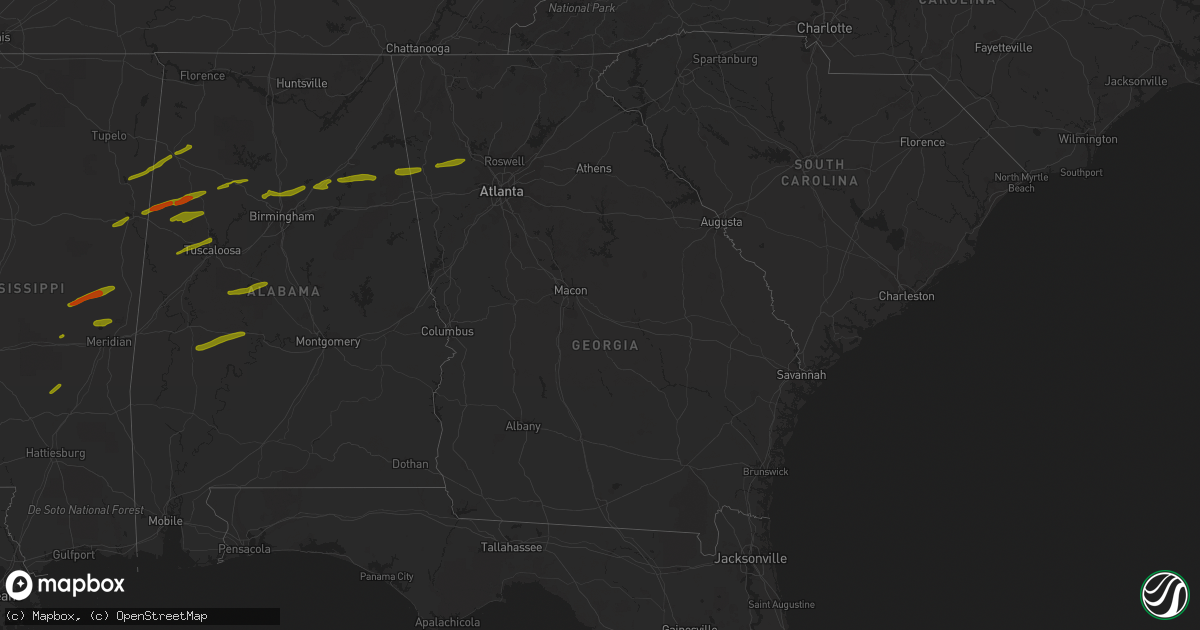
Hail Map in Georgia on March 14, 2019
Get this storm
March 14 map
$229
one time, instant access
Download today. No call, no setup
Keep the $229
Bought the map and want the full workflow? Apply the entire $229 to a subscription within 7 days. None of it is wasted.
Every map, not just this one
This buys you this map. Subscription and you get every map we run, in the markets you choose from a few cities to whole states to nationwide. Plus real-time alerts the moment a storm fires.
Contact data
Name, contact info, occupancy, even credit band for addresses in the footprint. You go from where it hit to who to call.
Become the source they trust
Unlimited branding weather history reports on demand. You already have the documented answer ready for the property owner, and you are the one who showed up with it.
Property data and RoofTrace estimates
Pull up any address you have got, its value and the exact code rules for that jurisdiction, straight from One Click Code. Then RoofTrace estimates the squares, pitch, and roof value, priced the way you price.
Storm reports in Georgia
Georgia
| Date | Description |
|---|---|
| 03/14/20196:04 AM CDT | At 1103 PM EDT, a severe thunderstorm was located near Woodland, or near Wedowee, moving northeast at 30 mph. HAZARD...70 mph wind gusts. SOURCE...Radar indicated. IMPACT...Expect considerable tree damage. Damage is likely to mobile homes, roofs, and outbuildings. Locations impacted include... Carrollton, Ephesus, Centralhatchee, Roopville, Frolona, Lowell, Plant Wansley, Tyus, Blackjack Mountain and Roosterville. |
| 03/14/20193:51 AM CDT | At 851 PM EDT, a severe thunderstorm was located over Yorkville, or 7 miles west of Dallas, moving east at 40 mph. HAZARD...60 mph wind gusts and quarter size hail. SOURCE...Radar indicated. IMPACT...Hail damage to vehicles is expected. Expect wind damage to roofs, siding, and trees. Locations impacted include... Marietta, Cartersville, Dallas, Kennesaw, Acworth, Rockmart, Hiram, Emerson, Braswell, Yorkville, Burnt Hickory Ridge, Kellogg Creek, Lost Mountain Park, Oak Grove, Kennesaw State University, Van Wert, George Washington Carver St Pk, Cross Roads, Due West and New Hope. |
| 03/14/20193:37 AM CDT | At 837 PM EDT, a severe thunderstorm was located over Kingston, or 9 miles northwest of Cartersville, moving east at 30 mph. HAZARD...60 mph wind gusts and quarter size hail. SOURCE...Radar indicated. IMPACT...Hail damage to vehicles is expected. Expect wind damage to roofs, siding, and trees. Locations impacted include... Cartersville, Adairsville, Euharlee, Emerson, White, Kingston, Cassville, Fairmount, Pine Log, Sutallee, Folsom and Funkhouser. |
| 03/14/20193:31 AM CDT | At 830 PM EDT, a severe thunderstorm was located near Felton, or near Cedartown, moving east at 20 mph. HAZARD...60 mph wind gusts and quarter size hail. SOURCE...Radar indicated. IMPACT...Hail damage to vehicles is expected. Expect wind damage to roofs, siding, and trees. Locations impacted include... Cedartown, Rockmart, Aragon, Braswell, Yorkville, Fish Creek, Eubank Lake, Antioch and Van Wert. |
| 03/14/20193:08 AM CDT | At 808 PM EDT, a severe thunderstorm was located over Oak Level, or 8 miles southeast of Piedmont, moving east at 20 mph. HAZARD...60 mph wind gusts and quarter size hail. SOURCE...Radar indicated. IMPACT...Hail damage to vehicles is expected. Expect wind damage to roofs, siding, and trees. Locations impacted include... Cedartown, Buchanan, Felton and Esom Hill. |
| 03/13/20197:32 PM CDT | Multiple trees down off of highway 27. One tree was snapped and two were uprooted onto a fence. |
| 03/13/20197:06 PM CDT | An ef0 tornado 150 yards wide with winds of 75 mph touched down 5 miles east of cave spring and was on the ground for about 1.75 miles. The tornado uprooted and snapped |
| 03/13/20197:05 PM CDT | Two trees and a power line were downed on booger hollow road. |
All States Impacted by Hail Map on March 14, 2019
Cities Impacted by Hail Map on March 14, 2019
- Aberdeen, MS
- Detroit, AL
- Hamilton, AL
- Beaverton, AL
- Sulligent, AL
- Greenwood Springs, MS
- Bear Creek, AL
- Hackleburg, AL
- Guin, AL
- Columbus, MS
- Scooba, MS
- Union, MS
- De Kalb, MS
- Philadelphia, MS
- Preston, MS
- Bankston, AL
- Carbon Hill, AL
- Fayette, AL
- Kennedy, AL
- Steens, MS
- Berry, AL
- Millport, AL
- Decatur, MS
- Stringer, MS
- Taylorsville, MS
- Bay Springs, MS
- Northport, AL
- Gordo, AL
- Reform, AL
- Daleville, MS
- Collinsville, MS
- Bailey, MS
- Meridian, MS
- Buhl, AL
- Coker, AL
- Townley, AL
- Oakman, AL
- Jasper, AL
- Mount Olive, AL
- Graysville, AL
- Morris, AL
- Warrior, AL
- Dora, AL
- Springville, AL
- Remlap, AL
- Birmingham, AL
- Gardendale, AL
- Pinson, AL
- Ashville, AL
- Centreville, AL
- Marion, AL
- Brent, AL
- Lawley, AL
- Wellington, AL
- Jacksonville, AL
- Rainbow City, AL
- Ohatchee, AL
- Piedmont, AL
- Gadsden, AL
- Buchanan, GA
- Cedartown, GA
- Thomaston, AL
- Marion Junction, AL
- Uniontown, AL
- Faunsdale, AL
- Linden, AL
- Safford, AL
- Adrian, MI
- Stryker, OH
- Bryan, OH
- Archbold, OH
- Fayette, OH
- Morenci, MI
- Sand Creek, MI
- West Unity, OH
- Clayton, MI
- Wauseon, OH
- Bellevue, MI
- Charlotte, MI
- Battle Creek, MI
- Olivet, MI
- Brooklyn, MI
- Jackson, MI
- Norvell, MI
- Manchester, MI
- Grass Lake, MI
- Chelsea, MI
- Dexter, MI
- Laingsburg, MI
- Bath, MI
- East Lansing, MI
- Perry, MI
- Haslett, MI
- Marion, KY
- Elizabethtown, IL
- Morganfield, KY
- Cave In Rock, IL
- Sturgis, KY
- Boonville, IN
- Tennyson, IN
- Velpen, IN
- Lynnville, IN
- Huntingburg, IN
- Dubois, IN
- Stendal, IN
- Oakland City, IN
- Chandler, IN
- Winslow, IN
- Elberfeld, IN
- Jasper, IN
- Clay, KY
- Gentryville, IN
- Dale, IN
- Newburgh, IN
- Holland, IN
- Mitchell, IN
- Orleans, IN
- Shoals, IN
- West Baden Springs, IN
- Celestine, IN
- French Lick, IN
- Paoli, IN
- Calhoun, KY
- Sebree, KY
- Owensboro, KY
- Robards, KY
- Henderson, KY
- Rockport, IN
- Vallonia, IN
- Campbellsburg, IN
- Seymour, IN
- Medora, IN
- Brownstown, IN
- Tell City, IN
- Branchville, IN
- Lewisport, KY
- Leopold, IN
- Troy, IN
- Hawesville, KY
- Cannelton, IN
- Borden, IN
- Depauw, IN
- Ramsey, IN
- Corydon, IN
- Milltown, IN
- New Salisbury, IN
- Leavenworth, IN
- Pekin, IN
- Greenville, IN
- Palmyra, IN
- Otisco, IN
- Memphis, IN
- Marysville, IN
- Henryville, IN
- Charlestown, IN
- Rising Sun, IN
- Dillsboro, IN
- Florence, IN
- Madison, IN
- Hanover, IN
- Milton, KY
- Vevay, IN
- Bennington, IN
- Lexington, IN
- Loveland, OH
- Camp Dennison, OH
- New Vienna, OH
- Goshen, OH
- Dayton, KY
- Florence, KY
- Milford, OH
- Hebron, KY
- Blanchester, OH
- Wilmington, OH
- Pleasant Plain, OH
- Cincinnati, OH
- Covington, KY
- Burlington, KY
- Ft Mitchell, KY
- Clarksville, OH
- Terrace Park, OH
- Miamiville, OH
- Sabina, OH
- Erlanger, KY
- Morrow, OH
- Smithfield, KY
- La Grange, KY
- Crestwood, KY
- Pewee Valley, KY
- Buckner, KY
- Louisville, KY
- Medway, OH
- Fairborn, OH
- Dayton, OH
- Silver Grove, KY
- Fort Thomas, KY
- Newport, KY
- Groveport, OH
- Pataskala, OH
- Baltimore, OH
- Reynoldsburg, OH
- Canal Winchester, OH
- Pickerington, OH
- Nelsonville, OH
- Logan, OH
- Haydenville, OH
- New Plymouth, OH
- Union Furnace, OH
- Petersburg, KY
- Bolingbrook, IL
- Mazon, IL
- Lemont, IL
- Verona, IL
- Woodridge, IL
- Morris, IL
- Minooka, IL
- Shorewood, IL
- Crest Hill, IL
- Lockport, IL
- Romeoville, IL
- Plainfield, IL
- Joliet, IL
- Westmont, IL
- Clarendon Hills, IL
- Oak Brook, IL
- Willowbrook, IL
- Darien, IL
- Westchester, IL
- Hinsdale, IL
- Western Springs, IL
- Martinton, IL
- Danforth, IL
- Saint Anne, IL
- Chebanse, IL
- Ashkum, IL
- Clifton, IL
- Channahon, IL
- Elwood, IL
- Chicago Heights, IL
- Schererville, IN
- Beecher, IL
- Gary, IN
- Dyer, IN
- Highland, IN
- Munster, IN
- Hammond, IN
- Griffith, IN
- Crete, IL
- Grant Park, IL
- Lowell, IN
- Momence, IL
- Kouts, IN
- Buchanan, MI
- La Porte, IN
- Hebron, IN
- Wanatah, IN
- Galien, MI
- New Carlisle, IN
- Rolling Prairie, IN
- Union Mills, IN
- Valparaiso, IN
- Westville, IN
- Stevensville, MI
- Watervliet, MI
- Bridgman, MI
- Hartford, MI
- Coloma, MI
- Benton Harbor, MI
- Saint Joseph, MI
- Wolcottville, IN
- Angola, IN
- Lagrange, IN
- Fremont, IN
- Hudson, IN
- Acworth, GA
- Rockmart, GA
- Dallas, GA
- Alexandria, KY
- Brookhaven, MS
- Monticello, MS
- Sontag, MS
- Oneonta, AL
- Cleveland, AL
- Hayden, AL
- Gattman, MS
- Caledonia, MS
- Butler, AL
- Steger, IL
- Greensboro, AL
- Porterville, MS
- Monee, IL
- Evansville, IN
- Prattville, AL
- Marbury, AL
- Deatsville, AL
- Dixon, KY
- South Milford, IN
- Kendallville, IN
- Starkville, MS
- Vernon, AL
- Ethelsville, AL
- Artesia, MS
- Nauvoo, AL
- Crawford, MS
- Quinton, AL
- Little Rock, MS
- Emelle, AL
- Lauderdale, MS
- Livingston, AL
- New Castle, KY
- Eminence, KY
- Sulphur, KY
- Campbellsburg, KY
- Alexandria, AL
- Ragland, AL
- Reed, KY
- Richland, IN
- Lisman, AL
- Ward, AL
- Jachin, AL
- Lake, MS
- Forest, MS
- Grandview, IN
- Corinth, KY
- Martinsville, OH
- Ney, OH
- Hillsboro, OH
- Lynchburg, OH
- Jemison, AL
- Randolph, AL
- Maplesville, AL
- Boaz, AL
- Attalla, AL
- Fort Payne, AL
- Collinsville, AL
- Parrish, AL
- Midland, OH
- Bellevue, KY
- Fayetteville, OH
- Bedford, KY
- Aurora, IN
- Union, KY
- Latonia, KY
- Mount Orab, OH
- Georgetown, IN
- Boligee, AL
- Forkland, AL
- Lawrence, MI
- Bangor, MI
- Lawrence, MS
- Conehatta, MS
- Columbus, OH
- Kevil, KY
- West Paducah, KY
- Cordova, AL
- Battletown, KY
- Crandall, IN
- Newhebron, MS
- Pinola, MS
- Batavia, OH
- Amelia, OH
- California, KY
- New Richmond, OH
- Lynn, AL
- Hampton, KY
- Brookport, IL
- Golconda, IL
- Metropolis, IL
- Smithland, KY
- Westport, KY
- Pendleton, KY
- Goshen, KY
- Freetown, IN
- Beverly Shores, IN
- Michigan City, IN
- Haleyville, AL
- Double Springs, AL
- Crossville, AL
- Adamsville, AL
- Brookside, AL
- Derby, IN
- Thorsby, AL
- Bedford, IN
- Tunnelton, IN
- Berry, KY
- North Liberty, IN
- Norman, IN
- Melbourne, KY
- Williamsburg, OH
- Providence, KY
- Slaughters, KY
- Blackstone, IL
- Kinsman, IL
- South Lyon, MI
- Albertville, AL
- Turners Station, KY
- Carrollton, KY
- Tallapoosa, GA
- Sawyerville, AL
- Walkerton, IN
- Fredericksburg, IN
- Plainville, GA
- Rome, GA
- Demotte, IN
- Brookwood, AL
- Homer, MI
- Cement City, MI
- Ann Arbor, MI
- Clarklake, MI
- Addison, MI
- Jerome, MI
- Corydon, KY
- Stevenson, AL
- Sumiton, AL
- Stonewall, MS
- Quitman, MS
- Pachuta, MS
- Enterprise, MS
- Saline, MI
- Wilmington, IL
- Locust Fork, AL
- Trafford, AL
- Stockbridge, MI
- Matteson, IL
- Verona, KY
- Walton, KY
- Crittenden, KY
- Elrod, AL
- Pennington, AL
- Moundville, AL
- Akron, AL
- Clanton, AL
- Lockbourne, OH
- Hamersville, OH
- De Mossville, KY
- Butler, KY
- Moscow, OH
- Bethel, OH
- Prospect, KY
- Eutaw, AL
- English, IN
- Eaton Rapids, MI
- Lansing, MI
- Grand Ledge, MI
- Potterville, MI
- Dimondale, MI
- Millington, MI
- Peotone, IL
- Amory, MS
- Carrollton, AL
- Maceo, KY
- Waverly, KY
- Georgetown, OH
- Felicity, OH
- Salem, KY
- Lanesville, IN
- New Middletown, IN
- Adger, AL
- Altoona, AL
- Gallant, AL
- Chesterton, IN
- Morning View, KY
- Independence, KY
- Thornton, IL
- Chicago, IL
- Olympia Fields, IL
- Hazel Crest, IL
- Dolton, IL
- Glenwood, IL
- Homewood, IL
- Flossmoor, IL
- Harvey, IL
- Riverdale, IL
- Calumet City, IL
- South Holland, IL
- Shelbyville, KY
- Finchville, KY
- Fisherville, KY
- Simpsonville, KY
- Paducah, KY
- Mize, MS
- Mount Olive, MS
- University Park, IL
- Fredonia, KY
- Bremen, AL
- Steele, AL
- Nebo, KY
- Evanston, IN
- Pleasant Lake, IN
- Jeffersonville, IN
- Brierfield, AL
- Wheatfield, IN
- Santa Claus, IN
- Chrisney, IN
- Sherwood, OH
- Titus, AL
- Vossburg, MS
- Eldridge, AL
- Winfield, AL
- Empire, AL
- Coal City, IL


