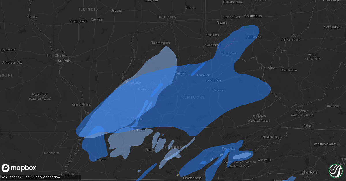
Hail Map in Kentucky on March 3, 2023
Get this storm
March 3 map
$229
one time, instant access
Download today. No call, no setup
Keep the $229
Bought the map and want the full workflow? Apply the entire $229 to a subscription within 7 days. None of it is wasted.
Every map, not just this one
This buys you this map. Subscription and you get every map we run, in the markets you choose from a few cities to whole states to nationwide. Plus real-time alerts the moment a storm fires.
Contact data
Name, contact info, occupancy, even credit band for addresses in the footprint. You go from where it hit to who to call.
Become the source they trust
Unlimited branding weather history reports on demand. You already have the documented answer ready for the property owner, and you are the one who showed up with it.
Property data and RoofTrace estimates
Pull up any address you have got, its value and the exact code rules for that jurisdiction, straight from One Click Code. Then RoofTrace estimates the squares, pitch, and roof value, priced the way you price.
Storm reports in Kentucky
Kentucky
| Date | Description |
|---|---|
| 03/03/20235:40 PM CST | Greenup county 911 has reports of a tree down blocking the road at 570 siloam ln in south shore. Time estimated by radar. |
| 03/03/20235:40 PM CST | Greenup county 911 passed along a report of a tree down blocking a lane of travel on state route 7 at brushy road in load. Time estimated by radar. |
| 03/03/20233:35 PM CST | A local report indicates 67 MPH wind near KYMESO OWENTON 5E |
| 03/03/20233:24 PM CST | A tree was down along johnson creek. The location and time is radar estimated. |
| 03/03/20233:13 PM CST | A local report indicates 70 MPH wind near 4 E CHESTNUT GROVE |
| 03/03/20233:07 PM CST | Trees down along harpers ferry road. |
| 03/03/20232:47 PM CST | Trees down along lake road near campbellsburg. |
| 03/03/20232:31 PM CST | Trees down along bourbon acres road. Additional trees down across the county with the storms. |
| 03/03/20232:30 PM CST | Trees were reported down along sandhill road. |
| 03/03/20231:50 PM CST | Tees were reported to have been blow down. |
| 03/03/20231:50 PM CST | Corrects previous tstm wnd dmg report from science hill. Trees were reported to have been blow down. |
| 03/03/20231:35 PM CST | Mesonet station brnd brandenburg 4 sw. |
| 03/03/20231:25 PM CST | Kentucky mesonet station hard hardinsburg. |
| 03/03/202312:55 PM CST | Awos station khop fort campbell ky. |
| 03/03/202312:52 PM CST | Trees down along knob lick road near edmonton. |
| 03/03/202312:45 PM CST | Mobile home home lifted and moved about 4 to 5 ft. Nearby carport moved into neighbors yard. Several barns destroyed in the area. |
| 03/03/202312:45 PM CST | Shingles off roofs... Some siding off of houses and trees down. |
| 03/03/202312:40 PM CST | Mesonet station 1578w logan aluminum. |
| 03/03/202312:39 PM CST | Trees down. |
| 03/03/202312:35 PM CST | Mesonet station ccty greenville ky 6 n. |
| 03/03/202312:35 PM CST | A local report indicates 60 MPH wind near 4 E HEBBARDSVILLE |
| 03/03/202312:30 PM CST | House with major roof shingle loss on hwy 531 just east of zion. Further down the road on hwy 531... A large barn lost part of its roof. |
| 03/03/202312:30 PM CST | Corrects previous tstm wnd dmg report from 4 sw spottsville. House with major roof shingle loss on hwy 351 just east of zion. Further down the road on hwy 351... A larg |
| 03/03/202312:29 PM CST | Trees and powerlines down near cave city. |
| 03/03/202312:15 PM CST | Barn damaged on hwy 56... Shed damaged at wmsk radio station... A roof gone off a home on the union/henderson county line. |
| 03/03/202312:15 PM CST | A local report indicates 63 MPH wind near 4 E MORGANFIELD |
| 03/03/202312:10 PM CST | A local report indicates 67 MPH wind near 6 N HOPKINSVILLE |
| 03/03/202312:00 PM CST | Several barns destroyed. Estimated at least 60 mph winds. |
| 03/03/202311:55 AM CST | A local report indicates 69 MPH wind near 3 SW CADIZ |
| 03/03/202311:38 AM CST | Personal weather station cwop - dw6462 murray. |
| 03/03/202311:35 AM CST | Pole barn damaged trees down. |
| 03/03/202311:26 AM CST | A local report indicates 70 MPH wind near CALVERT CITY |
| 03/03/202311:15 AM CST | Multiple power poles and power lines down in and around the city. |
| 03/03/202311:09 AM CST | Corrects previous tornado report from 5 wsw reidland. Damaged homes and trees down in the fremont area reported by off duty nws employee. Time determined from radar. |
| 03/03/202311:09 AM CST | Several trees down in greenville/central city area. |
| 03/03/202311:08 AM CST | Corrects previous tornado report from 5 nne boaz. An ef-2 tornado began at 1108 am cst just west of the intersection of old mayfield road and mcneil road. Traveling nne |
| 03/03/202311:07 AM CST | Damaged homes and trees down in the fremont area reported by off duty nws employee. |
| 03/03/202311:00 AM CST | Mesonet station pryb mayfield ky 6 sw. |
| 03/03/202310:40 AM CST | Mesonet station hckm hickman ky 2 e. |
| 03/02/202311:08 PM CST | An ef-2 tornado began at 1108 am cst just west of the intersection of old mayfield road and mcneil road. Traveling nne... The tornado paralleled old mayfield road... Do |
All States Impacted by Hail Map on March 3, 2023
Cities Impacted by Hail Map on March 3, 2023
- Aberdeen, MS
- Hamilton, MS
- Greenwood Springs, MS
- Amory, MS
- Caledonia, MS
- Sulligent, AL
- Gattman, MS
- Winfield, AL
- Detroit, AL
- Beaverton, AL
- Guin, AL
- Fayette, AL
- Brilliant, AL
- Hamilton, AL
- Hackleburg, AL
- Tremont, MS
- Smithville, MS
- Golden, MS
- Fulton, MS
- Vina, AL
- Red Bay, AL
- Hodges, AL
- Phil Campbell, AL
- Belmont, MS
- Leighton, AL
- Spruce Pine, AL
- Trinity, AL
- Mount Hope, AL
- Moulton, AL
- Danville, AL
- Courtland, AL
- Decatur, AL
- Russellville, AL
- Hillsboro, AL
- Town Creek, AL
- Tuscumbia, AL
- Dennis, MS
- New Site, MS
- Oak Grove, KY
- Herndon, KY
- Fort Campbell, KY
- Hopkinsville, KY
- Pembroke, KY
- Elkton, KY
- Crofton, KY
- Greenville, KY
- Central City, KY
- Tiptonville, TN
- Hickman, KY
- Portageville, MO
- Troy, TN
- Union City, TN
- Ridgely, TN
- Hornbeak, TN
- Rives, TN
- South Fulton, TN
- East Prairie, MO
- Fulton, KY
- Water Valley, KY
- Mayfield, KY
- Clinton, KY
- Wingo, KY
- Kirksey, KY
- Arlington, KY
- Bardwell, KY
- Columbus, KY
- Wickliffe, KY
- Fancy Farm, KY
- Cunningham, KY
- Hickory, KY
- Charleston, MO
- New Madrid, MO
- Kevil, KY
- Benton, KY
- Symsonia, KY
- Paducah, KY
- Melber, KY
- Boaz, KY
- Hartselle, AL
- Somerville, AL
- La Center, KY
- Calvert City, KY
- Brookport, IL
- West Paducah, KY
- Metropolis, IL
- Barlow, KY
- Ledbetter, KY
- Eldridge, AL
- Carbon Hill, AL
- Townley, AL
- Nauvoo, AL
- Jasper, AL
- Lynn, AL
- Double Springs, AL
- Haleyville, AL
- Houston, AL
- Bear Creek, AL
- Rogersville, AL
- Muscle Shoals, AL
- Smithland, KY
- Golconda, IL
- Grand Rivers, KY
- Madison, AL
- Huntsville, AL
- Tanner, AL
- Burna, KY
- Drakesboro, KY
- Centertown, KY
- Rockport, KY
- Powderly, KY
- Dunmor, KY
- Belton, KY
- Beaver Dam, KY
- Browder, KY
- Beechmont, KY
- Beech Creek, KY
- Gilbertsville, KY
- Tiline, KY
- Hampton, KY
- Marion, KY
- Kuttawa, KY
- Fredonia, KY
- Eddyville, KY
- Salem, KY
- Eddyville, IL
- Arley, AL
- Crane Hill, AL
- Addison, AL
- Bremen, AL
- Cullman, AL
- Logan, AL
- Princeton, KY
- Herod, IL
- Elizabethtown, IL
- Rosiclare, IL
- Brownsboro, AL
- Gurley, AL
- New Market, AL
- Hollytree, AL
- Princeton, AL
- Toney, AL
- Meridianville, AL
- Shelbyville, TN
- Fayetteville, TN
- Petersburg, TN
- Wartrace, TN
- Bell Buckle, TN
- Christiana, TN
- Beechgrove, TN
- Bradyville, TN
- Woodbury, TN
- Morrison, TN
- Manchester, TN
- Mcminnville, TN
- Obion, TN
- Dukedom, TN
- Almo, KY
- Cottage Grove, TN
- Martin, TN
- Dexter, KY
- Dresden, TN
- Sedalia, KY
- Hazel, KY
- Hardin, KY
- Palmersville, TN
- Puryear, TN
- Murray, KY
- Farmington, KY
- Cadiz, KY
- New Concord, KY
- Bumpus Mills, TN
- Dover, TN
- Gracey, KY
- Cerulean, KY
- Sturgis, KY
- Dawson Springs, KY
- Providence, KY
- Cave In Rock, IL
- Nebo, KY
- Morganfield, KY
- Clay, KY
- Five Points, TN
- Loretto, TN
- Anderson, AL
- Lexington, AL
- Leoma, TN
- Minor Hill, TN
- Prospect, TN
- Pulaski, TN
- Goodspring, TN
- Cornersville, TN
- Lewisburg, TN
- Lynnville, TN
- Belfast, TN
- Estillfork, AL
- Scottsboro, AL
- Stevenson, AL
- Sherwood, TN
- Belvidere, TN
- Huntland, TN
- Saint Charles, KY
- White Plains, KY
- Nortonville, KY
- Earlington, KY
- Graham, KY
- Madisonville, KY
- Mortons Gap, KY
- Hanson, KY
- Shawneetown, IL
- Sacramento, KY
- New Haven, IL
- Sebree, KY
- Uniontown, KY
- Henderson, KY
- Manitou, KY
- Bremen, KY
- Corydon, KY
- Rumsey, KY
- Robards, KY
- Island, KY
- Dixon, KY
- Mount Vernon, IN
- Equality, IL
- Junction, IL
- Slaughters, KY
- Waverly, KY
- Ridgway, IL
- Newburgh, IN
- Reed, KY
- Evansville, IN
- Calhoun, KY
- Owensboro, KY
- Spottsville, KY
- Wadesville, IN
- Utica, KY
- Smithville, TN
- Sparta, TN
- Cookeville, TN
- Sewanee, TN
- South Pittsburg, TN
- Bridgeport, AL
- Chattanooga, TN
- Jasper, TN
- Guild, TN
- Whitwell, TN
- Dunlap, TN
- Sequatchie, TN
- Signal Mountain, TN
- Tracy City, TN
- Livermore, KY
- Chandler, IN
- Morgantown, KY
- Rochester, KY
- McHenry, KY
- Hartford, KY
- Cromwell, KY
- Philpot, KY
- Richland, IN
- Whitesville, KY
- Rockport, IN
- Boonville, IN
- Hayden, AL
- Blountsville, AL
- Elberfeld, IN
- Lynnville, IN
- Haubstadt, IN
- Oakland City, IN
- Fort Branch, IN
- Maceo, KY
- Tennyson, IN
- Chrisney, IN
- Olaton, KY
- Rosine, KY
- Fordsville, KY
- Horse Branch, KY
- Dundee, KY
- Lewisport, KY
- Palmer, TN
- Hixson, TN
- Soddy Daisy, TN
- Falls Of Rough, KY
- Caneyville, KY
- Reynolds Station, KY
- Hawesville, KY
- Grandview, IN
- Troy, IN
- Spurgeon, IN
- Dale, IN
- Lincoln City, IN
- Lamar, IN
- Evanston, IN
- Santa Claus, IN
- Tell City, IN
- Cannelton, IN
- Stendal, IN
- Gentryville, IN
- Cloverport, KY
- Winslow, IN
- Velpen, IN
- Holland, IN
- Huntingburg, IN
- Ferdinand, IN
- Monterey, TN
- Rickman, TN
- Crawford, TN
- Dayton, TN
- Evensville, TN
- Decatur, TN
- Jasper, IN
- Saint Meinrad, IN
- Otwell, IN
- Saint Anthony, IN
- Montgomery, IN
- Bristow, IN
- Petersburg, IN
- Cannelburg, IN
- Garfield, KY
- Hardinsburg, KY
- Irvington, KY
- Rome, IN
- Harned, KY
- Schnellville, IN
- Birdseye, IN
- Rhodelia, KY
- Webster, KY
- Celestine, IN
- Eckerty, IN
- Leopold, IN
- Dubois, IN
- Saint Croix, IN
- English, IN
- Loogootee, IN
- Leavenworth, IN
- Battletown, KY
- Branchville, IN
- Union Star, KY
- Stephensport, KY
- Payneville, KY
- Derby, IN
- Harrison, TN
- Brandenburg, KY
- Guston, KY
- Shoals, IN
- French Lick, IN
- Sulphur, IN
- Fultondale, AL
- Birmingham, AL
- Fairfield, AL
- Docena, AL
- Mulga, AL
- Pleasant Grove, AL
- Bessemer, AL
- Dolomite, AL
- Trussville, AL
- Odenville, AL
- Springville, AL
- Pinson, AL
- Ashville, AL
- Oneonta, AL
- Steele, AL
- Attalla, AL
- Gadsden, AL
- Rainbow City, AL
- Centre, AL
- Leesburg, AL
- Taswell, IN
- Mitchell, IN
- West Baden Springs, IN
- Collinsville, AL
- Cedar Bluff, AL
- Paoli, IN
- Grantsburg, IN
- Marengo, IN
- Corydon, IN
- Milltown, IN
- Ekron, KY
- Mauckport, IN
- Central, IN
- Trion, GA
- Lyerly, GA
- Gaylesville, AL
- Summerville, GA
- Laconia, IN
- Elizabeth, IN
- Depauw, IN
- Hardinsburg, IN
- New Middletown, IN
- New Salisbury, IN
- Ramsey, IN
- Orleans, IN
- Williams, IN
- Salem, IN
- Palmyra, IN
- Pekin, IN
- Fredericksburg, IN
- Greenville, IN
- Georgetown, IN
- Lanesville, IN
- Campbellsburg, IN
- Crandall, IN
- Tunnelton, IN
- Bedford, IN
- Oolitic, IN
- Norman, IN
- Scottsburg, IN
- Heltonville, IN
- Floyds Knobs, IN
- Vallonia, IN
- Medora, IN
- Borden, IN
- Brownstown, IN
- Crothersville, IN
- Freetown, IN
- Englewood, TN
- Madisonville, TN
- Vonore, TN
- Greenback, TN
- Maryville, TN
- Friendsville, TN
- Alcoa, TN
- Louisville, TN
- Rockford, TN
- Knoxville, TN
- Lenoir City, TN
- Rome, GA
- Mount Berry, GA
- Kingston, GA
- Adairsville, GA
- Calhoun, GA
- Plainville, GA
- Rydal, GA
- Talking Rock, GA
- Jasper, GA
- Fairmount, GA
- Ranger, GA
- Simpsonville, KY
- Shelbyville, KY
- Eminence, KY
- Pleasureville, KY
- Bethlehem, KY
- Lockport, KY
- Owenton, KY
- Dahlonega, GA
- Bethel, OH
- Williamsburg, OH
- Mount Orab, OH
- Niota, TN
- Sweetwater, TN
- Philadelphia, TN
- Lynchburg, OH
- Hillsboro, OH
- New Vienna, OH
- Nettleton, MS
- Saltillo, MS
- Tupelo, MS
- Mooreville, MS
- Marietta, MS
- Mantachie, MS
- Prairie, MS
- West Point, MS
- Pearl, MS
- Flowood, MS
- Jackson, MS
- Richland, MS
- Brandon, MS
- Terry, MS
- Raymond, MS
- Byram, MS
- Florence, MS
- Utica, MS
- Woodruff, SC
- Duncan, SC
- Moore, SC
- Spartanburg, SC
- Roebuck, SC
- Glendale, SC
- Gaffney, SC
- Mount Airy, NC
- Lowgap, NC
- Ararat, VA
- Cana, VA
- Fancy Gap, VA
- Lambsburg, VA
- Hillsville, VA
- Meadows Of Dan, VA
- Laurel Fork, VA
- Stuart, VA
- Woolwine, VA
- Pauline, SC
- Jonesville, SC
- Pacolet, SC
- Blacksburg, SC
- Smyrna, SC
- Hickory Grove, SC
- Dawsonville, GA
- Section, AL
- Dutton, AL
- Pisgah, AL
- Henagar, AL
- Cedar Grove, TN
- Gleason, TN
- Medina, TN
- Friendship, TN
- Jackson, TN
- Oakfield, TN
- Trimble, TN
- Brownsville, TN
- Dyersburg, TN
- Sharon, TN
- Bells, TN
- Rutherford, TN
- Alamo, TN
- Atwood, TN
- Humboldt, TN
- Halls, TN
- Lavinia, TN
- Trenton, TN
- Trezevant, TN
- Finley, TN
- Kenton, TN
- McKenzie, TN
- Denmark, TN
- Newbern, TN
- Dyer, TN
- Huntingdon, TN
- Milan, TN
- Bradford, TN
- Greenfield, TN
- Gadsden, TN
- Lexington, TN
- Beech Bluff, TN
- Tennessee Ridge, TN
- Hurricane Mills, TN
- Holladay, TN
- Bruceton, TN
- Mansfield, TN
- Stewart, TN
- New Johnsonville, TN
- Hollow Rock, TN
- Paris, TN
- Springville, TN
- Eva, TN
- Big Sandy, TN
- Westport, TN
- Camden, TN
- Buena Vista, TN
- Waverly, TN
- Big Rock, TN
- Buchanan, TN
- Henry, TN
- Yuma, TN
- Parsons, TN
- Sugar Tree, TN
- Wildersville, TN
- Darden, TN
- Lobelville, TN
- Linden, TN
- Indian Mound, TN
- Erin, TN
- McEwen, TN
- Cumberland City, TN
- Dickson, TN
- Charlotte, TN
- Vanleer, TN
- Cumberland Furnace, TN
- Clarksville, TN
- Palmyra, TN
- Ashland City, TN
- Cunningham, TN
- Chapmansboro, TN
- Woodlawn, TN
- White Bluff, TN
- Southside, TN
- Joelton, TN
- Pleasant View, TN
- Springfield, TN
- Adams, TN
- Greenbrier, TN
- Cedar Hill, TN
- Only, TN
- Centerville, TN
- White House, TN
- Old Hickory, TN
- Madison, TN
- Whites Creek, TN
- Brentwood, TN
- Nashville, TN
- Hendersonville, TN
- Goodlettsville, TN
- Franklin, TN
- Gallatin, TN
- Cottontown, TN
- Nolensville, TN
- Murfreesboro, TN
- Arrington, TN
- Antioch, TN
- Smyrna, TN
- La Vergne, TN
- Lebanon, TN
- Mount Juliet, TN
- Hermitage, TN
- College Grove, TN
- Milton, TN
- Auburntown, TN
- Gordonsville, TN
- Watertown, TN
- Lascassas, TN
- Alexandria, TN
- Brush Creek, TN
- Dowelltown, TN
- Liberty, TN
- Readyville, TN
- Heiskell, TN
- Kingston, TN
- Rockwood, TN
- Grandview, TN
- Powell, TN
- Clinton, TN
- Ten Mile, TN
- Powder Springs, TN
- Briceville, TN
- Crossville, TN
- Crab Orchard, TN
- Oliver Springs, TN
- Maynardville, TN
- Luttrell, TN
- Oak Ridge, TN
- Harriman, TN
- Andersonville, TN
- Blaine, TN
- Farragut, TN
- Loudon, TN
- Rutledge, TN
- Wartburg, TN
- Spring City, TN
- Pikeville, TN
- Oakdale, TN
- Corryton, TN
- Washburn, TN
- Graysville, TN
- Coalmont, TN
- Gruetli Laager, TN
- Sale Creek, TN
- Birchwood, TN
- Athens, TN
- Georgetown, TN
- Riceville, TN
- Etowah, TN
- Calhoun, TN
- Delano, TN
- Charleston, TN
- Cleveland, TN
- Benton, TN
- Tellico Plains, TN
- Ocoee, TN
- Crandall, GA
- Old Fort, TN
- Cisco, GA
- Reliance, TN
- Tallassee, TN
- Mascot, TN
- Strawberry Plains, TN
- Seymour, TN
- Walland, TN
- Kodak, TN
- Townsend, TN
- Pigeon Forge, TN
- Dandridge, TN
- Jefferson City, TN
- New Market, TN
- Sevierville, TN
- Cosby, TN
- Gatlinburg, TN
- Robbinsville, NC
- Bryson City, NC
- Clyde, NC
- Hartford, TN
- Cherokee, NC
- Del Rio, TN
- Newport, TN
- Talbott, TN
- Morristown, TN
- Sharpsburg, KY
- Germantown, KY
- Lexington, KY
- Millersburg, KY
- Sadieville, KY
- Moorefield, KY
- Flemingsburg, KY
- West Union, OH
- Salvisa, KY
- North Middletown, KY
- Brooksville, KY
- Mayslick, KY
- Augusta, KY
- Manchester, OH
- Mount Olivet, KY
- Winchester, KY
- Stamping Ground, KY
- Ewing, KY
- Maysville, KY
- Nicholasville, KY
- Vanceburg, KY
- Winchester, OH
- Aberdeen, OH
- Tollesboro, KY
- Ripley, OH
- Versailles, KY
- Dover, KY
- Midway, KY
- Lawrenceburg, KY
- Cynthiana, KY
- Russellville, OH
- Paris, KY
- Wilmore, KY
- Carlisle, KY
- Georgetown, KY
- Bagdad, KY
- Frankfort, KY
- Corinth, KY
- Prospect, KY
- New Castle, KY
- Crestwood, KY
- Louisville, KY
- Shepherdsville, KY
- Glenview, KY
- Waddy, KY
- Jeffersonville, IN
- Mount Eden, KY
- Masonic Home, KY
- Brooks, KY
- Taylorsville, KY
- Fisherville, KY
- New Albany, IN
- Buckner, KY
- Clarksville, IN
- Finchville, KY
- Pewee Valley, KY
- Fairdale, KY
- La Grange, KY
- Sellersburg, IN
- Smithfield, KY
- Mount Washington, KY
- Horse Cave, KY
- Buffalo, KY
- Bloomfield, KY
- Lebanon, KY
- Summersville, KY
- Saint Catharine, KY
- Knob Lick, KY
- New Haven, KY
- Raywick, KY
- Springfield, KY
- Loretto, KY
- Boston, KY
- Cave City, KY
- Canmer, KY
- Gravel Switch, KY
- New Hope, KY
- Bradfordsville, KY
- Willisburg, KY
- Campbellsville, KY
- Bardstown, KY
- Center, KY
- Magnolia, KY
- Hodgenville, KY
- Hardyville, KY
- Coxs Creek, KY
- Greensburg, KY
- Munfordville, KY
- Saint Francis, KY
- Mount Sherman, KY
- Edmonton, KY
- Perryville, KY
- Fairfield, KY
- Chaplin, KY
- Harrodsburg, KY
- Mackville, KY
- Liberty, KY
- Elk Horn, KY
- Columbia, KY
- Mannsville, KY
- Knifley, KY
- Parksville, KY
- Gradyville, KY
- Glasgow, KY
- Dunnville, KY
- Russell Springs, KY
- Glens Fork, KY
- Summer Shade, KY
- Eighty Eight, KY
- Lawrenceburg, TN
- Ethridge, TN
- Burns, TN
- Lewisburg, KY
- Rockfield, KY
- Jetson, KY
- Russellville, KY
- Oakland, KY
- Auburn, KY
- Bee Spring, KY
- Roundhill, KY
- Brownsville, KY
- Bowling Green, KY
- Franklin, KY
- Alvaton, KY
- Sweeden, KY
- Woodburn, KY
- Scottsville, KY
- Portland, TN
- Holland, KY
- Adolphus, KY
- Gamaliel, KY
- Fountain Run, KY
- Tompkinsville, KY
- Etoile, KY
- Austin, KY
- Mount Hermon, KY
- West Point, KY
- Custer, KY
- White Mills, KY
- Leitchfield, KY
- Glendale, KY
- Rocky Hill, KY
- Fort Knox, KY
- Upton, KY
- Westmoreland, TN
- Sonora, KY
- Elizabethtown, KY
- Big Clifty, KY
- Smiths Grove, KY
- Mammoth Cave, KY
- Lucas, KY
- Westview, KY
- Radcliff, KY
- McDaniels, KY
- Beaumont, KY
- Eastview, KY
- Hudson, KY
- Cecilia, KY
- Clarkson, KY
- Vine Grove, KY
- Park City, KY
- Millwood, KY
- Bonnieville, KY
- Cub Run, KY
- Muldraugh, KY
- Adairville, KY
- Rineyville, KY
- Lebanon Junction, KY
- Clermont, KY
- Burkesville, KY
- Breeding, KY
- Hustonville, KY
- Junction City, KY
- Danville, KY
- Burgin, KY
- Lafayette, TN
- Lancaster, KY
- Byrdstown, TN
- Alpha, KY
- Stearns, KY
- Albany, KY
- Monticello, KY
- Hestand, KY
- Pall Mall, TN
- Science Hill, KY
- Nancy, KY
- Windsor, KY
- Jamestown, KY
- Yosemite, KY
- Middleburg, KY
- Kings Mountain, KY
- Stanford, KY
- Paint Lick, KY
- Berea, KY
- Richmond, KY
- Waynesburg, KY
- Crab Orchard, KY
- Waco, KY
- Stout, OH
- Wallingford, KY
- Friendship, OH
- Lynx, OH
- Oak Hill, OH
- Londonderry, OH
- Otway, OH
- Minford, OH
- Ray, OH
- Portsmouth, OH
- Jackson, OH
- Garrison, KY
- Piketon, OH
- Peebles, OH
- West Portsmouth, OH
- Lucasville, OH
- South Portsmouth, KY
- Blue Creek, OH
- Chillicothe, OH
- South Bloomingville, OH
- Beaver, OH
- Richmond Dale, OH
- McDermott, OH
- Waverly, OH
- Wheelersburg, OH
- Rarden, OH
- South Webster, OH
- Frankfort, OH
- Millersport, OH
- Thurston, OH
- Bainbridge, OH
- Kirkersville, OH
- Pataskala, OH
- Adelphi, OH
- Pickerington, OH
- Circleville, OH
- Stoutsville, OH
- Hebron, OH
- Ashville, OH
- Baltimore, OH
- Pleasantville, OH
- Kingston, OH
- Tarlton, OH
- Lancaster, OH
- Carroll, OH
- Canal Winchester, OH
- Latham, OH
- Granville, OH
- Laurelville, OH
- Amanda, OH
- Groveport, OH
- Williamsport, OH
- Lithopolis, OH
- South Salem, OH
- Alexandria, OH
- Etna, OH
- Clarksburg, OH
- Reynoldsburg, OH
- Grove City, OH
- Washington Court House, OH
- Mount Sterling, OH
- Blacklick, OH
- Orient, OH
- Greenfield, OH
- Columbus, OH
- Commercial Point, OH
- Lockbourne, OH
- New Holland, OH
- Seaman, OH
- Bloomingburg, OH
- Sabina, OH
- Leesburg, OH
- Wilmington, OH
- Blanchester, OH
- Martinsville, OH
- Pleasant Plain, OH
- Berry, KY
- Morning View, KY
- Melbourne, KY
- Owensville, OH
- Falmouth, KY
- Goshen, OH
- Loveland, OH
- Hamersville, OH
- Cincinnati, OH
- Neville, OH
- Batavia, OH
- California, KY
- Georgetown, OH
- Felicity, OH
- Foster, KY
- Milford, OH
- Sardinia, OH
- Fayetteville, OH
- New Richmond, OH
- Williamstown, KY
- Dry Ridge, KY
- De Mossville, KY
- Amelia, OH
- Midland, OH
- Moscow, OH
- Butler, KY
- Alexandria, KY
- Quincy, KY
- Charlestown, IN
- Goshen, KY
- South Shore, KY
- Westport, KY
- Marysville, IN
- Memphis, IN
- Bedford, KY
- Perry Park, KY
- New Liberty, KY
- Pendleton, KY
- Turners Station, KY
- Campbellsburg, KY
- Sulphur, KY
- Worthville, KY
- Bronston, KY
- Burnside, KY
- Ferguson, KY
- Eubank, KY
- Whitley City, KY
- Bethelridge, KY
- Somerset, KY
- Vest, KY
- Orlando, KY
- Brodhead, KY
- Dwale, KY
- West Van Lear, KY
- Jackson, KY
- Thelma, KY
- Garrett, KY
- Mousie, KY
- Hyden, KY
- Hazard, KY
- Langley, KY
- Printer, KY
- Lost Creek, KY
- Gunlock, KY
- Gays Creek, KY
- Keavy, KY
- Van Lear, KY
- River, KY
- Hueysville, KY
- Tyner, KY
- Chavies, KY
- Emmalena, KY
- Leburn, KY
- Hagerhill, KY
- Clayhole, KY
- Meally, KY
- Corbin, KY
- Annville, KY
- Royalton, KY
- Banner, KY
- Ary, KY
- Bulan, KY
- Sextons Creek, KY
- Allen, KY
- Ivel, KY
- Prestonsburg, KY
- Tutor Key, KY
- Wayland, KY
- David, KY
- Rowdy, KY
- East Point, KY
- Oneida, KY
- Lackey, KY
- Salyersville, KY
- Livingston, KY
- Minnie, KY
- Manchester, KY
- Garner, KY
- Williamsport, KY
- Buckhorn, KY
- Krypton, KY
- Staffordsville, KY
- Paintsville, KY
- Grethel, KY
- London, KY
- Eastern, KY
- Parkers Lake, KY
- Mount Vernon, KY
- Martin, KY
- Blue River, KY
- Dana, KY
- East Bernstadt, KY
- Drift, KY
- McDowell, KY
- Auxier, KY
- Harold, KY
- McKee, KY
- Vincent, KY
- Booneville, KY
- Fort Gay, WV
- Irvine, KY
- Campton, KY
- Rousseau, KY
- Zoe, KY
- Varney, KY
- Williamson, WV
- Boons Camp, KY
- Warfield, KY
- Kermit, WV
- Sitka, KY
- Sandgap, KY
- Slade, KY
- Pikeville, KY
- Ravenna, KY
- Lenore, WV
- Beattyville, KY
- Debord, KY
- Blaine, KY
- Lovely, KY
- Stambaugh, KY
- Whick, KY
- Vancleve, KY
- Sidney, KY
- Louisa, KY
- Lowmansville, KY
- Crum, WV
- Tram, KY
- Inez, KY
- Flatgap, KY
- Rogers, KY
- Tomahawk, KY
- Beauty, KY
- Cannel City, KY
- Keaton, KY
- Pine Ridge, KY
- Pilgrim, KY
- Ricetown, KY
- Belfry, KY
- Mize, KY
- Hazel Green, KY
- Oil Springs, KY
- Wittensville, KY
- Bays, KY
- Stanton, KY
- West Liberty, KY
- Ulysses, KY
- Stanville, KY
- Betsy Layne, KY
- Mistletoe, KY
- Isonville, KY
- Clearfield, KY
- Clay City, KY
- Wellington, KY
- Denniston, KY
- Martha, KY
- Means, KY
- Mount Sterling, KY
- Salt Lick, KY
- Frenchburg, KY
- Owingsville, KY
- Ezel, KY
- Sandy Hook, KY
- Morehead, KY
- Elkfork, KY
- Olympia, KY
- Jeffersonville, KY
- Hope, KY
- Adams, KY
- Webbville, KY
- Olive Hill, KY
- Hillsboro, KY
- Sharon Grove, KY
- La Fayette, KY
- Trenton, KY
- Olmstead, KY
- Allensville, KY
- Guthrie, KY
- Simpson, IL
- Karnak, IL
- Grand Chain, IL
- Belknap, IL
- Grantsburg, IL
- Cairo, IL
- Anniston, MO
- Lilbourn, MO
- Bertrand, MO
- Marston, MO
- Matthews, MO
- Orlinda, TN
- Red Boiling Springs, TN
- Jamestown, TN
- Allons, TN
- Celina, TN
- Hilham, TN
- Alpine, TN
- Livingston, TN
- Moss, TN
- Whitleyville, TN
- Monroe, TN
- Sheffield, AL
- Florence, AL
- Killen, AL
- Athens, AL
- Owens Cross Roads, AL
- Harvest, AL
- Woodville, AL
- Paint Rock, AL
- New Hope, AL
- Marshall, NC
- Greeneville, TN
- Hot Springs, NC
- Afton, TN
- Chuckey, TN
- Parrottsville, TN
- Medon, TN
- Mercer, TN
- Pinson, TN
- Henderson, TN
- Huron, TN
- Luray, TN
- Finger, TN
- Jacks Creek, TN
- Reagan, TN
- Enville, TN
- Olivehill, TN
- Saltillo, TN
- Waynesboro, TN
- Savannah, TN
- Scotts Hill, TN
- Sardis, TN
- Clifton, TN
- Bath Springs, TN
- Decaturville, TN
- Hohenwald, TN
- Summertown, TN
- Columbia, TN
- Mount Pleasant, TN
- Williamsport, TN
- Hampshire, TN
- Duck River, TN
- Fairview, TN
- Nunnelly, TN
- Kingston Springs, TN
- Bon Aqua, TN
- Primm Springs, TN
- Lyles, TN
- Santa Fe, TN
- Thompsons Station, TN


