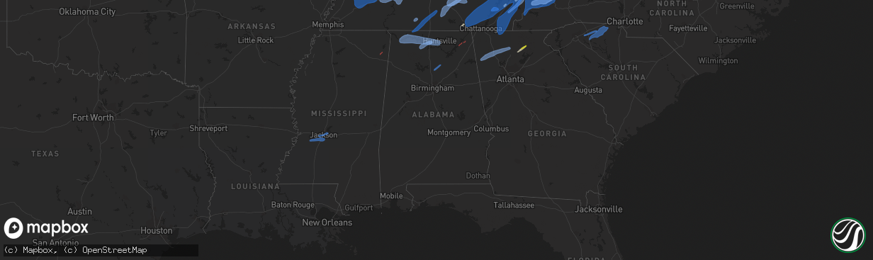
Hail Map in Alabama on March 3, 2023
The weather event in Alabama on March 3, 2023 includes Wind, Tornado, and Hail maps. 13 states and 1,224 cities were impacted and suffered possible damage. The total estimated number of properties impacted is 0.
Want more than just the map?
Turn this storm into a full workflow.
- Owner + property data so you know who to knock
- OnDemand branded weather history reports to win the "did we even have hail?" argument
- RoofTrace estimate so reps stop guessing numbers at the door
Bought this map? Upgrade within 7 days and we'll credit the $230. (10-15 min setup call)
Wind
Tornado
Hail
0
Estimated number of impacted properties by a 1.00" hail or larger0
Estimated number of impacted properties by a 1.75" hail or larger0
Estimated number of impacted properties by a 2.50" hail or largerStorm reports in Alabama
Alabama
| Date | Description |
|---|---|
| 03/03/20231:40 PM CST | Roof reported blown off house on cherokee county road 778. Time estimated from radar. |
| 03/03/20231:17 PM CST | Numerous trees down across cherokee county... Including tree on house along hwy 9 in cedar bluff. No injuries reported. |
| 03/03/20231:06 PM CST | Several trees were blown down near cropwell... Near pell city... And near ragland. |
| 03/03/20231:00 PM CST | Large tree down blocking noccalula road. Via social media... Time estimated from radar. |
| 03/03/202312:47 PM CST | A nws storm survey team found evidence of an ef-1 tornado in jackson county in pisgah... Al. |
| 03/03/202312:46 PM CST | Numerous trees down on cr 61 near pisgah. Possible tornado. |
| 03/03/202312:40 PM CST | A nws storm survey team found evidence of an ef-1 tornado in jackson county extending from section... Al into dutton... Al. |
| 03/03/202312:32 PM CST | Multiple trees reported down in springville... Including grove rd... Washington valley rd... Industrial dr... Burgess dr... Jones rd and evergreen rd. Roof damage on be |
| 03/03/202312:32 PM CST | Multiple trees reported down in springville... Including grove rd... Washington valley rd... And evergreen rd. Roof damage on beason lane. |
| 03/03/202312:24 PM CST | Facade torn off of the parking deck at 2nd ave and 19th street n across from mcwane center. Via social media. |
| 03/03/202312:13 PM CST | Structure damage on hytop rd |
| 03/03/202312:10 PM CST | Roof blown off of mobile home on graves gap rd north of hayden. Time estimated from radar. |
| 03/03/202312:10 PM CST | Tree across residence unknown injury and trees down around blountsville elementary. School without power. Page street blountsville. Time based on radar. |
| 03/03/202312:04 PM CST | Trees down on camp oliver road and paul oliver road in oak grove. A law enforcement vehicle was trapped by the downed tree... But no injuries reported. |
| 03/03/202311:45 AM CST | Widespread trees downed across the city of cullman. |
| 03/03/202311:40 AM CST | Multiple reports of trees down in research park. |
| 03/03/202311:36 AM CST | Numerous trees were blown down between oakman and berry. |
| 03/03/202311:28 AM CST | Khsv reports a gust of 58 kt. |
| 03/03/202311:25 AM CST | Roof and sign damage at the bank of walker county in jasper. Time estimated from radar. Via social media. |
| 03/03/202311:24 AM CST | Numerous trees were blown down all over the county. |
| 03/03/202311:18 AM CST | Kdcu reports a wind gust of 67 kt. |
| 03/03/202311:06 AM CST | Numerous trees were blown down across the northern part of walker county. Some roads remain impassable. |
| 03/03/202311:00 AM CST | Trees down near cr 87 and cr 331. |
| 03/03/202310:55 AM CST | Trees down and roads block at al 101/cr 406. |
| 03/03/202310:40 AM CST | A few trees were blown down on cr 391. |
| 03/03/202310:36 AM CST | Several trees down in multiple pickens county towns. |
| 03/03/202310:34 AM CST | Ksml reports a wind gust of 52 kt. |
| 03/03/202310:30 AM CST | Numerous reports of trees and power lines down near russellville. |
| 03/03/202310:30 AM CST | Co-op observer reported trees blown down in both marion and winston counties near haleyville. |
| 03/03/202310:30 AM CST | Multiple downed trees reported along us43 in guin. |
| 03/03/202310:14 AM CST | Trees and power lines down throughout sulligent... Also on highway 278. |
| 03/03/202310:11 AM CST | Reports coming in of trees down all along the line of storms in marion county west of hamilton. |
| 03/03/202310:03 AM CST | *** 1 inj *** trees down and report of a minor injury. |
| 03/03/20239:50 AM CST | Numerous reports of trees and power lines down near red bay. |
All States Impacted by Hail Map on March 3, 2023
Cities Impacted by Hail Map on March 3, 2023
- Aberdeen, MS
- Hamilton, MS
- Greenwood Springs, MS
- Amory, MS
- Caledonia, MS
- Sulligent, AL
- Gattman, MS
- Winfield, AL
- Detroit, AL
- Beaverton, AL
- Guin, AL
- Fayette, AL
- Brilliant, AL
- Hamilton, AL
- Hackleburg, AL
- Tremont, MS
- Smithville, MS
- Golden, MS
- Fulton, MS
- Vina, AL
- Red Bay, AL
- Hodges, AL
- Phil Campbell, AL
- Belmont, MS
- Leighton, AL
- Spruce Pine, AL
- Trinity, AL
- Mount Hope, AL
- Moulton, AL
- Danville, AL
- Courtland, AL
- Decatur, AL
- Russellville, AL
- Hillsboro, AL
- Town Creek, AL
- Tuscumbia, AL
- Dennis, MS
- New Site, MS
- Oak Grove, KY
- Herndon, KY
- Fort Campbell, KY
- Hopkinsville, KY
- Pembroke, KY
- Elkton, KY
- Crofton, KY
- Greenville, KY
- Central City, KY
- Tiptonville, TN
- Hickman, KY
- Portageville, MO
- Troy, TN
- Union City, TN
- Ridgely, TN
- Hornbeak, TN
- Rives, TN
- South Fulton, TN
- East Prairie, MO
- Fulton, KY
- Water Valley, KY
- Mayfield, KY
- Clinton, KY
- Wingo, KY
- Kirksey, KY
- Arlington, KY
- Bardwell, KY
- Columbus, KY
- Wickliffe, KY
- Fancy Farm, KY
- Cunningham, KY
- Hickory, KY
- Charleston, MO
- New Madrid, MO
- Kevil, KY
- Benton, KY
- Symsonia, KY
- Paducah, KY
- Melber, KY
- Boaz, KY
- Hartselle, AL
- Somerville, AL
- La Center, KY
- Calvert City, KY
- Brookport, IL
- West Paducah, KY
- Metropolis, IL
- Barlow, KY
- Ledbetter, KY
- Eldridge, AL
- Carbon Hill, AL
- Townley, AL
- Nauvoo, AL
- Jasper, AL
- Lynn, AL
- Double Springs, AL
- Haleyville, AL
- Houston, AL
- Bear Creek, AL
- Rogersville, AL
- Muscle Shoals, AL
- Smithland, KY
- Golconda, IL
- Grand Rivers, KY
- Madison, AL
- Huntsville, AL
- Tanner, AL
- Burna, KY
- Drakesboro, KY
- Centertown, KY
- Rockport, KY
- Powderly, KY
- Dunmor, KY
- Belton, KY
- Beaver Dam, KY
- Browder, KY
- Beechmont, KY
- Beech Creek, KY
- Gilbertsville, KY
- Tiline, KY
- Hampton, KY
- Marion, KY
- Kuttawa, KY
- Fredonia, KY
- Eddyville, KY
- Salem, KY
- Eddyville, IL
- Arley, AL
- Crane Hill, AL
- Addison, AL
- Bremen, AL
- Cullman, AL
- Logan, AL
- Princeton, KY
- Herod, IL
- Elizabethtown, IL
- Rosiclare, IL
- Brownsboro, AL
- Gurley, AL
- New Market, AL
- Hollytree, AL
- Princeton, AL
- Toney, AL
- Meridianville, AL
- Shelbyville, TN
- Fayetteville, TN
- Petersburg, TN
- Wartrace, TN
- Bell Buckle, TN
- Christiana, TN
- Beechgrove, TN
- Bradyville, TN
- Woodbury, TN
- Morrison, TN
- Manchester, TN
- Mcminnville, TN
- Obion, TN
- Dukedom, TN
- Almo, KY
- Cottage Grove, TN
- Martin, TN
- Dexter, KY
- Dresden, TN
- Sedalia, KY
- Hazel, KY
- Hardin, KY
- Palmersville, TN
- Puryear, TN
- Murray, KY
- Farmington, KY
- Cadiz, KY
- New Concord, KY
- Bumpus Mills, TN
- Dover, TN
- Gracey, KY
- Cerulean, KY
- Sturgis, KY
- Dawson Springs, KY
- Providence, KY
- Cave In Rock, IL
- Nebo, KY
- Morganfield, KY
- Clay, KY
- Five Points, TN
- Loretto, TN
- Anderson, AL
- Lexington, AL
- Leoma, TN
- Minor Hill, TN
- Prospect, TN
- Pulaski, TN
- Goodspring, TN
- Cornersville, TN
- Lewisburg, TN
- Lynnville, TN
- Belfast, TN
- Estillfork, AL
- Scottsboro, AL
- Stevenson, AL
- Sherwood, TN
- Belvidere, TN
- Huntland, TN
- Saint Charles, KY
- White Plains, KY
- Nortonville, KY
- Earlington, KY
- Graham, KY
- Madisonville, KY
- Mortons Gap, KY
- Hanson, KY
- Shawneetown, IL
- Sacramento, KY
- New Haven, IL
- Sebree, KY
- Uniontown, KY
- Henderson, KY
- Manitou, KY
- Bremen, KY
- Corydon, KY
- Rumsey, KY
- Robards, KY
- Island, KY
- Dixon, KY
- Mount Vernon, IN
- Equality, IL
- Junction, IL
- Slaughters, KY
- Waverly, KY
- Ridgway, IL
- Newburgh, IN
- Reed, KY
- Evansville, IN
- Calhoun, KY
- Owensboro, KY
- Spottsville, KY
- Wadesville, IN
- Utica, KY
- Smithville, TN
- Sparta, TN
- Cookeville, TN
- Sewanee, TN
- South Pittsburg, TN
- Bridgeport, AL
- Chattanooga, TN
- Jasper, TN
- Guild, TN
- Whitwell, TN
- Dunlap, TN
- Sequatchie, TN
- Signal Mountain, TN
- Tracy City, TN
- Livermore, KY
- Chandler, IN
- Morgantown, KY
- Rochester, KY
- McHenry, KY
- Hartford, KY
- Cromwell, KY
- Philpot, KY
- Richland, IN
- Whitesville, KY
- Rockport, IN
- Boonville, IN
- Hayden, AL
- Blountsville, AL
- Elberfeld, IN
- Lynnville, IN
- Haubstadt, IN
- Oakland City, IN
- Fort Branch, IN
- Maceo, KY
- Tennyson, IN
- Chrisney, IN
- Olaton, KY
- Rosine, KY
- Fordsville, KY
- Horse Branch, KY
- Dundee, KY
- Lewisport, KY
- Palmer, TN
- Hixson, TN
- Soddy Daisy, TN
- Falls Of Rough, KY
- Caneyville, KY
- Reynolds Station, KY
- Hawesville, KY
- Grandview, IN
- Troy, IN
- Spurgeon, IN
- Dale, IN
- Lincoln City, IN
- Lamar, IN
- Evanston, IN
- Santa Claus, IN
- Tell City, IN
- Cannelton, IN
- Stendal, IN
- Gentryville, IN
- Cloverport, KY
- Winslow, IN
- Velpen, IN
- Holland, IN
- Huntingburg, IN
- Ferdinand, IN
- Monterey, TN
- Rickman, TN
- Crawford, TN
- Dayton, TN
- Evensville, TN
- Decatur, TN
- Jasper, IN
- Saint Meinrad, IN
- Otwell, IN
- Saint Anthony, IN
- Montgomery, IN
- Bristow, IN
- Petersburg, IN
- Cannelburg, IN
- Garfield, KY
- Hardinsburg, KY
- Irvington, KY
- Rome, IN
- Harned, KY
- Schnellville, IN
- Birdseye, IN
- Rhodelia, KY
- Webster, KY
- Celestine, IN
- Eckerty, IN
- Leopold, IN
- Dubois, IN
- Saint Croix, IN
- English, IN
- Loogootee, IN
- Leavenworth, IN
- Battletown, KY
- Branchville, IN
- Union Star, KY
- Stephensport, KY
- Payneville, KY
- Derby, IN
- Harrison, TN
- Brandenburg, KY
- Guston, KY
- Shoals, IN
- French Lick, IN
- Sulphur, IN
- Fultondale, AL
- Birmingham, AL
- Fairfield, AL
- Docena, AL
- Mulga, AL
- Pleasant Grove, AL
- Bessemer, AL
- Dolomite, AL
- Trussville, AL
- Odenville, AL
- Springville, AL
- Pinson, AL
- Ashville, AL
- Oneonta, AL
- Steele, AL
- Attalla, AL
- Gadsden, AL
- Rainbow City, AL
- Centre, AL
- Leesburg, AL
- Taswell, IN
- Mitchell, IN
- West Baden Springs, IN
- Collinsville, AL
- Cedar Bluff, AL
- Paoli, IN
- Grantsburg, IN
- Marengo, IN
- Corydon, IN
- Milltown, IN
- Ekron, KY
- Mauckport, IN
- Central, IN
- Trion, GA
- Lyerly, GA
- Gaylesville, AL
- Summerville, GA
- Laconia, IN
- Elizabeth, IN
- Depauw, IN
- Hardinsburg, IN
- New Middletown, IN
- New Salisbury, IN
- Ramsey, IN
- Orleans, IN
- Williams, IN
- Salem, IN
- Palmyra, IN
- Pekin, IN
- Fredericksburg, IN
- Greenville, IN
- Georgetown, IN
- Lanesville, IN
- Campbellsburg, IN
- Crandall, IN
- Tunnelton, IN
- Bedford, IN
- Oolitic, IN
- Norman, IN
- Scottsburg, IN
- Heltonville, IN
- Floyds Knobs, IN
- Vallonia, IN
- Medora, IN
- Borden, IN
- Brownstown, IN
- Crothersville, IN
- Freetown, IN
- Englewood, TN
- Madisonville, TN
- Vonore, TN
- Greenback, TN
- Maryville, TN
- Friendsville, TN
- Alcoa, TN
- Louisville, TN
- Rockford, TN
- Knoxville, TN
- Lenoir City, TN
- Rome, GA
- Mount Berry, GA
- Kingston, GA
- Adairsville, GA
- Calhoun, GA
- Plainville, GA
- Rydal, GA
- Talking Rock, GA
- Jasper, GA
- Fairmount, GA
- Ranger, GA
- Simpsonville, KY
- Shelbyville, KY
- Eminence, KY
- Pleasureville, KY
- Bethlehem, KY
- Lockport, KY
- Owenton, KY
- Dahlonega, GA
- Bethel, OH
- Williamsburg, OH
- Mount Orab, OH
- Niota, TN
- Sweetwater, TN
- Philadelphia, TN
- Lynchburg, OH
- Hillsboro, OH
- New Vienna, OH
- Nettleton, MS
- Saltillo, MS
- Tupelo, MS
- Mooreville, MS
- Marietta, MS
- Mantachie, MS
- Prairie, MS
- West Point, MS
- Pearl, MS
- Flowood, MS
- Jackson, MS
- Richland, MS
- Brandon, MS
- Terry, MS
- Raymond, MS
- Byram, MS
- Florence, MS
- Utica, MS
- Woodruff, SC
- Duncan, SC
- Moore, SC
- Spartanburg, SC
- Roebuck, SC
- Glendale, SC
- Gaffney, SC
- Mount Airy, NC
- Lowgap, NC
- Ararat, VA
- Cana, VA
- Fancy Gap, VA
- Lambsburg, VA
- Hillsville, VA
- Meadows Of Dan, VA
- Laurel Fork, VA
- Stuart, VA
- Woolwine, VA
- Pauline, SC
- Jonesville, SC
- Pacolet, SC
- Blacksburg, SC
- Smyrna, SC
- Hickory Grove, SC
- Dawsonville, GA
- Section, AL
- Dutton, AL
- Pisgah, AL
- Henagar, AL
- Cedar Grove, TN
- Gleason, TN
- Medina, TN
- Friendship, TN
- Jackson, TN
- Oakfield, TN
- Trimble, TN
- Brownsville, TN
- Dyersburg, TN
- Sharon, TN
- Bells, TN
- Rutherford, TN
- Alamo, TN
- Atwood, TN
- Humboldt, TN
- Halls, TN
- Lavinia, TN
- Trenton, TN
- Trezevant, TN
- Finley, TN
- Kenton, TN
- McKenzie, TN
- Denmark, TN
- Newbern, TN
- Dyer, TN
- Huntingdon, TN
- Milan, TN
- Bradford, TN
- Greenfield, TN
- Gadsden, TN
- Lexington, TN
- Beech Bluff, TN
- Tennessee Ridge, TN
- Hurricane Mills, TN
- Holladay, TN
- Bruceton, TN
- Mansfield, TN
- Stewart, TN
- New Johnsonville, TN
- Hollow Rock, TN
- Paris, TN
- Springville, TN
- Eva, TN
- Big Sandy, TN
- Westport, TN
- Camden, TN
- Buena Vista, TN
- Waverly, TN
- Big Rock, TN
- Buchanan, TN
- Henry, TN
- Yuma, TN
- Parsons, TN
- Sugar Tree, TN
- Wildersville, TN
- Darden, TN
- Lobelville, TN
- Linden, TN
- Indian Mound, TN
- Erin, TN
- McEwen, TN
- Cumberland City, TN
- Dickson, TN
- Charlotte, TN
- Vanleer, TN
- Cumberland Furnace, TN
- Clarksville, TN
- Palmyra, TN
- Ashland City, TN
- Cunningham, TN
- Chapmansboro, TN
- Woodlawn, TN
- White Bluff, TN
- Southside, TN
- Joelton, TN
- Pleasant View, TN
- Springfield, TN
- Adams, TN
- Greenbrier, TN
- Cedar Hill, TN
- Only, TN
- Centerville, TN
- White House, TN
- Old Hickory, TN
- Madison, TN
- Whites Creek, TN
- Brentwood, TN
- Nashville, TN
- Hendersonville, TN
- Goodlettsville, TN
- Franklin, TN
- Gallatin, TN
- Cottontown, TN
- Nolensville, TN
- Murfreesboro, TN
- Arrington, TN
- Antioch, TN
- Smyrna, TN
- La Vergne, TN
- Lebanon, TN
- Mount Juliet, TN
- Hermitage, TN
- College Grove, TN
- Milton, TN
- Auburntown, TN
- Gordonsville, TN
- Watertown, TN
- Lascassas, TN
- Alexandria, TN
- Brush Creek, TN
- Dowelltown, TN
- Liberty, TN
- Readyville, TN
- Heiskell, TN
- Kingston, TN
- Rockwood, TN
- Grandview, TN
- Powell, TN
- Clinton, TN
- Ten Mile, TN
- Powder Springs, TN
- Briceville, TN
- Crossville, TN
- Crab Orchard, TN
- Oliver Springs, TN
- Maynardville, TN
- Luttrell, TN
- Oak Ridge, TN
- Harriman, TN
- Andersonville, TN
- Blaine, TN
- Farragut, TN
- Loudon, TN
- Rutledge, TN
- Wartburg, TN
- Spring City, TN
- Pikeville, TN
- Oakdale, TN
- Corryton, TN
- Washburn, TN
- Graysville, TN
- Coalmont, TN
- Gruetli Laager, TN
- Sale Creek, TN
- Birchwood, TN
- Athens, TN
- Georgetown, TN
- Riceville, TN
- Etowah, TN
- Calhoun, TN
- Delano, TN
- Charleston, TN
- Cleveland, TN
- Benton, TN
- Tellico Plains, TN
- Ocoee, TN
- Crandall, GA
- Old Fort, TN
- Cisco, GA
- Reliance, TN
- Tallassee, TN
- Mascot, TN
- Strawberry Plains, TN
- Seymour, TN
- Walland, TN
- Kodak, TN
- Townsend, TN
- Pigeon Forge, TN
- Dandridge, TN
- Jefferson City, TN
- New Market, TN
- Sevierville, TN
- Cosby, TN
- Gatlinburg, TN
- Robbinsville, NC
- Bryson City, NC
- Clyde, NC
- Hartford, TN
- Cherokee, NC
- Del Rio, TN
- Newport, TN
- Talbott, TN
- Morristown, TN
- Sharpsburg, KY
- Germantown, KY
- Lexington, KY
- Millersburg, KY
- Sadieville, KY
- Moorefield, KY
- Flemingsburg, KY
- West Union, OH
- Salvisa, KY
- North Middletown, KY
- Brooksville, KY
- Mayslick, KY
- Augusta, KY
- Manchester, OH
- Mount Olivet, KY
- Winchester, KY
- Stamping Ground, KY
- Ewing, KY
- Maysville, KY
- Nicholasville, KY
- Vanceburg, KY
- Winchester, OH
- Aberdeen, OH
- Tollesboro, KY
- Ripley, OH
- Versailles, KY
- Dover, KY
- Midway, KY
- Lawrenceburg, KY
- Cynthiana, KY
- Russellville, OH
- Paris, KY
- Wilmore, KY
- Carlisle, KY
- Georgetown, KY
- Bagdad, KY
- Frankfort, KY
- Corinth, KY
- Prospect, KY
- New Castle, KY
- Crestwood, KY
- Louisville, KY
- Shepherdsville, KY
- Glenview, KY
- Waddy, KY
- Jeffersonville, IN
- Mount Eden, KY
- Masonic Home, KY
- Brooks, KY
- Taylorsville, KY
- Fisherville, KY
- New Albany, IN
- Buckner, KY
- Clarksville, IN
- Finchville, KY
- Pewee Valley, KY
- Fairdale, KY
- La Grange, KY
- Sellersburg, IN
- Smithfield, KY
- Mount Washington, KY
- Horse Cave, KY
- Buffalo, KY
- Bloomfield, KY
- Lebanon, KY
- Summersville, KY
- Saint Catharine, KY
- Knob Lick, KY
- New Haven, KY
- Raywick, KY
- Springfield, KY
- Loretto, KY
- Boston, KY
- Cave City, KY
- Canmer, KY
- Gravel Switch, KY
- New Hope, KY
- Bradfordsville, KY
- Willisburg, KY
- Campbellsville, KY
- Bardstown, KY
- Center, KY
- Magnolia, KY
- Hodgenville, KY
- Hardyville, KY
- Coxs Creek, KY
- Greensburg, KY
- Munfordville, KY
- Saint Francis, KY
- Mount Sherman, KY
- Edmonton, KY
- Perryville, KY
- Fairfield, KY
- Chaplin, KY
- Harrodsburg, KY
- Mackville, KY
- Liberty, KY
- Elk Horn, KY
- Columbia, KY
- Mannsville, KY
- Knifley, KY
- Parksville, KY
- Gradyville, KY
- Glasgow, KY
- Dunnville, KY
- Russell Springs, KY
- Glens Fork, KY
- Summer Shade, KY
- Eighty Eight, KY
- Lawrenceburg, TN
- Ethridge, TN
- Burns, TN
- Lewisburg, KY
- Rockfield, KY
- Jetson, KY
- Russellville, KY
- Oakland, KY
- Auburn, KY
- Bee Spring, KY
- Roundhill, KY
- Brownsville, KY
- Bowling Green, KY
- Franklin, KY
- Alvaton, KY
- Sweeden, KY
- Woodburn, KY
- Scottsville, KY
- Portland, TN
- Holland, KY
- Adolphus, KY
- Gamaliel, KY
- Fountain Run, KY
- Tompkinsville, KY
- Etoile, KY
- Austin, KY
- Mount Hermon, KY
- West Point, KY
- Custer, KY
- White Mills, KY
- Leitchfield, KY
- Glendale, KY
- Rocky Hill, KY
- Fort Knox, KY
- Upton, KY
- Westmoreland, TN
- Sonora, KY
- Elizabethtown, KY
- Big Clifty, KY
- Smiths Grove, KY
- Mammoth Cave, KY
- Lucas, KY
- Westview, KY
- Radcliff, KY
- McDaniels, KY
- Beaumont, KY
- Eastview, KY
- Hudson, KY
- Cecilia, KY
- Clarkson, KY
- Vine Grove, KY
- Park City, KY
- Millwood, KY
- Bonnieville, KY
- Cub Run, KY
- Muldraugh, KY
- Adairville, KY
- Rineyville, KY
- Lebanon Junction, KY
- Clermont, KY
- Burkesville, KY
- Breeding, KY
- Hustonville, KY
- Junction City, KY
- Danville, KY
- Burgin, KY
- Lafayette, TN
- Lancaster, KY
- Byrdstown, TN
- Alpha, KY
- Stearns, KY
- Albany, KY
- Monticello, KY
- Hestand, KY
- Pall Mall, TN
- Science Hill, KY
- Nancy, KY
- Windsor, KY
- Jamestown, KY
- Yosemite, KY
- Middleburg, KY
- Kings Mountain, KY
- Stanford, KY
- Paint Lick, KY
- Berea, KY
- Richmond, KY
- Waynesburg, KY
- Crab Orchard, KY
- Waco, KY
- Stout, OH
- Wallingford, KY
- Friendship, OH
- Lynx, OH
- Oak Hill, OH
- Londonderry, OH
- Otway, OH
- Minford, OH
- Ray, OH
- Portsmouth, OH
- Jackson, OH
- Garrison, KY
- Piketon, OH
- Peebles, OH
- West Portsmouth, OH
- Lucasville, OH
- South Portsmouth, KY
- Blue Creek, OH
- Chillicothe, OH
- South Bloomingville, OH
- Beaver, OH
- Richmond Dale, OH
- McDermott, OH
- Waverly, OH
- Wheelersburg, OH
- Rarden, OH
- South Webster, OH
- Frankfort, OH
- Millersport, OH
- Thurston, OH
- Bainbridge, OH
- Kirkersville, OH
- Pataskala, OH
- Adelphi, OH
- Pickerington, OH
- Circleville, OH
- Stoutsville, OH
- Hebron, OH
- Ashville, OH
- Baltimore, OH
- Pleasantville, OH
- Kingston, OH
- Tarlton, OH
- Lancaster, OH
- Carroll, OH
- Canal Winchester, OH
- Latham, OH
- Granville, OH
- Laurelville, OH
- Amanda, OH
- Groveport, OH
- Williamsport, OH
- Lithopolis, OH
- South Salem, OH
- Alexandria, OH
- Etna, OH
- Clarksburg, OH
- Reynoldsburg, OH
- Grove City, OH
- Washington Court House, OH
- Mount Sterling, OH
- Blacklick, OH
- Orient, OH
- Greenfield, OH
- Columbus, OH
- Commercial Point, OH
- Lockbourne, OH
- New Holland, OH
- Seaman, OH
- Bloomingburg, OH
- Sabina, OH
- Leesburg, OH
- Wilmington, OH
- Blanchester, OH
- Martinsville, OH
- Pleasant Plain, OH
- Berry, KY
- Morning View, KY
- Melbourne, KY
- Owensville, OH
- Falmouth, KY
- Goshen, OH
- Loveland, OH
- Hamersville, OH
- Cincinnati, OH
- Neville, OH
- Batavia, OH
- California, KY
- Georgetown, OH
- Felicity, OH
- Foster, KY
- Milford, OH
- Sardinia, OH
- Fayetteville, OH
- New Richmond, OH
- Williamstown, KY
- Dry Ridge, KY
- De Mossville, KY
- Amelia, OH
- Midland, OH
- Moscow, OH
- Butler, KY
- Alexandria, KY
- Quincy, KY
- Charlestown, IN
- Goshen, KY
- South Shore, KY
- Westport, KY
- Marysville, IN
- Memphis, IN
- Bedford, KY
- Perry Park, KY
- New Liberty, KY
- Pendleton, KY
- Turners Station, KY
- Campbellsburg, KY
- Sulphur, KY
- Worthville, KY
- Bronston, KY
- Burnside, KY
- Ferguson, KY
- Eubank, KY
- Whitley City, KY
- Bethelridge, KY
- Somerset, KY
- Vest, KY
- Orlando, KY
- Brodhead, KY
- Dwale, KY
- West Van Lear, KY
- Jackson, KY
- Thelma, KY
- Garrett, KY
- Mousie, KY
- Hyden, KY
- Hazard, KY
- Langley, KY
- Printer, KY
- Lost Creek, KY
- Gunlock, KY
- Gays Creek, KY
- Keavy, KY
- Van Lear, KY
- River, KY
- Hueysville, KY
- Tyner, KY
- Chavies, KY
- Emmalena, KY
- Leburn, KY
- Hagerhill, KY
- Clayhole, KY
- Meally, KY
- Corbin, KY
- Annville, KY
- Royalton, KY
- Banner, KY
- Ary, KY
- Bulan, KY
- Sextons Creek, KY
- Allen, KY
- Ivel, KY
- Prestonsburg, KY
- Tutor Key, KY
- Wayland, KY
- David, KY
- Rowdy, KY
- East Point, KY
- Oneida, KY
- Lackey, KY
- Salyersville, KY
- Livingston, KY
- Minnie, KY
- Manchester, KY
- Garner, KY
- Williamsport, KY
- Buckhorn, KY
- Krypton, KY
- Staffordsville, KY
- Paintsville, KY
- Grethel, KY
- London, KY
- Eastern, KY
- Parkers Lake, KY
- Mount Vernon, KY
- Martin, KY
- Blue River, KY
- Dana, KY
- East Bernstadt, KY
- Drift, KY
- McDowell, KY
- Auxier, KY
- Harold, KY
- McKee, KY
- Vincent, KY
- Booneville, KY
- Fort Gay, WV
- Irvine, KY
- Campton, KY
- Rousseau, KY
- Zoe, KY
- Varney, KY
- Williamson, WV
- Boons Camp, KY
- Warfield, KY
- Kermit, WV
- Sitka, KY
- Sandgap, KY
- Slade, KY
- Pikeville, KY
- Ravenna, KY
- Lenore, WV
- Beattyville, KY
- Debord, KY
- Blaine, KY
- Lovely, KY
- Stambaugh, KY
- Whick, KY
- Vancleve, KY
- Sidney, KY
- Louisa, KY
- Lowmansville, KY
- Crum, WV
- Tram, KY
- Inez, KY
- Flatgap, KY
- Rogers, KY
- Tomahawk, KY
- Beauty, KY
- Cannel City, KY
- Keaton, KY
- Pine Ridge, KY
- Pilgrim, KY
- Ricetown, KY
- Belfry, KY
- Mize, KY
- Hazel Green, KY
- Oil Springs, KY
- Wittensville, KY
- Bays, KY
- Stanton, KY
- West Liberty, KY
- Ulysses, KY
- Stanville, KY
- Betsy Layne, KY
- Mistletoe, KY
- Isonville, KY
- Clearfield, KY
- Clay City, KY
- Wellington, KY
- Denniston, KY
- Martha, KY
- Means, KY
- Mount Sterling, KY
- Salt Lick, KY
- Frenchburg, KY
- Owingsville, KY
- Ezel, KY
- Sandy Hook, KY
- Morehead, KY
- Elkfork, KY
- Olympia, KY
- Jeffersonville, KY
- Hope, KY
- Adams, KY
- Webbville, KY
- Olive Hill, KY
- Hillsboro, KY
- Sharon Grove, KY
- La Fayette, KY
- Trenton, KY
- Olmstead, KY
- Allensville, KY
- Guthrie, KY
- Simpson, IL
- Karnak, IL
- Grand Chain, IL
- Belknap, IL
- Grantsburg, IL
- Cairo, IL
- Anniston, MO
- Lilbourn, MO
- Bertrand, MO
- Marston, MO
- Matthews, MO
- Orlinda, TN
- Red Boiling Springs, TN
- Jamestown, TN
- Allons, TN
- Celina, TN
- Hilham, TN
- Alpine, TN
- Livingston, TN
- Moss, TN
- Whitleyville, TN
- Monroe, TN
- Sheffield, AL
- Florence, AL
- Killen, AL
- Athens, AL
- Owens Cross Roads, AL
- Harvest, AL
- Woodville, AL
- Paint Rock, AL
- New Hope, AL
- Marshall, NC
- Greeneville, TN
- Hot Springs, NC
- Afton, TN
- Chuckey, TN
- Parrottsville, TN
- Medon, TN
- Mercer, TN
- Pinson, TN
- Henderson, TN
- Huron, TN
- Luray, TN
- Finger, TN
- Jacks Creek, TN
- Reagan, TN
- Enville, TN
- Olivehill, TN
- Saltillo, TN
- Waynesboro, TN
- Savannah, TN
- Scotts Hill, TN
- Sardis, TN
- Clifton, TN
- Bath Springs, TN
- Decaturville, TN
- Hohenwald, TN
- Summertown, TN
- Columbia, TN
- Mount Pleasant, TN
- Williamsport, TN
- Hampshire, TN
- Duck River, TN
- Fairview, TN
- Nunnelly, TN
- Kingston Springs, TN
- Bon Aqua, TN
- Primm Springs, TN
- Lyles, TN
- Santa Fe, TN
- Thompsons Station, TN


