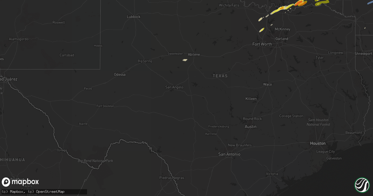
Hail Map in Texas on February 28, 2021
Get this storm
February 28 map
$229
one time, instant access
Download today. No call, no setup
Keep the $229
Bought the map and want the full workflow? Apply the entire $229 to a subscription within 7 days. None of it is wasted.
Every map, not just this one
This buys you this map. Subscription and you get every map we run, in the markets you choose from a few cities to whole states to nationwide. Plus real-time alerts the moment a storm fires.
Contact data
Name, contact info, occupancy, even credit band for addresses in the footprint. You go from where it hit to who to call.
Become the source they trust
Unlimited branding weather history reports on demand. You already have the documented answer ready for the property owner, and you are the one who showed up with it.
Property data and RoofTrace estimates
Pull up any address you have got, its value and the exact code rules for that jurisdiction, straight from One Click Code. Then RoofTrace estimates the squares, pitch, and roof value, priced the way you price.
Storm reports in Texas
Texas
| Date | Description |
|---|---|
| 02/28/202110:03 AM CST | Trained spotter reporting copious amounts of quarter size hail. |
| 02/28/202110:00 AM CST | Spotter measured ping pong ball size hail at fm406 and katy lane northeast of pottsboro. |
| 02/28/20219:48 AM CST | Quarter size hail reported 3 miles north of sadler in grayson county. |
| 02/28/20215:18 AM CST | At 1117 AM CST, a severe thunderstorm was located near Krum, or near Denton, moving northeast at 40 mph. HAZARD...Quarter size hail. SOURCE...Radar indicated. IMPACT...Damage to vehicles is possible. Locations impacted include... Denton, Sanger, Whitesboro, Celina, Krum, Pilot Point, Argyle, Justin, Van Alstyne, Howe, Aubrey, Northlake, Krugerville, Collinsville, Cross Roads, Gunter, Dorchester, Corral City, Ray Roberts Park Isle Du Bois and Lake Kiowa.This includes the following highways... Interstate 35 between mile markers 468 and 486. Interstate 35W between mile markers 77 and 85. Interstate 35E between mile markers 461 and 466. |
| 02/28/20214:02 AM CST | At 1001 AM CST, a severe thunderstorm was located over southeastern Lake Texoma, moving northeast at 50 mph. HAZARD...60 mph wind gusts and quarter size hail. SOURCE...Radar indicated. IMPACT...Hail damage to vehicles is expected. Expect wind damage to roofs, siding, and trees. Locations impacted include... Durant, Colbert, Caddo, Bokchito, Achille, Kemp, Armstrong, Hendrix, Cartwright, Blue, Utica, Albany, eastern Lake Texoma, Calera and Wade. |
All States Impacted by Hail Map on February 28, 2021
Cities Impacted by Hail Map on February 28, 2021
- Justin, TX
- Ponder, TX
- Tyronza, AR
- Turrell, AR
- Earle, AR
- Cherry Valley, AR
- Franklin, KY
- Portland, TN
- Sherman, TX
- Denison, TX
- Cartwright, OK
- Sadler, TX
- Pottsboro, TX
- Colbert, OK
- Pilot Point, TX
- Aubrey, TX
- Sawyer, OK
- Fort Towson, OK
- Westmoreland, TN
- Lebanon, TN
- Mount Juliet, TN
- Hendersonville, TN
- Whites Creek, TN
- Old Hickory, TN
- Goodlettsville, TN
- Gallatin, TN
- Nashville, TN
- Madison, TN
- Bennington, OK
- Boswell, OK
- Bokchito, OK
- Quitman, AR
- Wynne, AR
- Gilmore, AR
- Hickory Ridge, AR
- Marked Tree, AR
- Merkel, TX
- Tuscola, TX
- Greenbrier, TN
- White House, TN
- Whitesboro, TX
- Durant, OK
- Hendrix, OK
- Calera, OK
- Atoka, OK
- Story, AR
- Rosston, TX
- Muenster, TX
- Decatur, TX
- Era, TX
- Gainesville, TX
- Hugo, OK
- Cottontown, TN
- Bethpage, TN
- Chapmansboro, TN
- Cedar Hill, TN
- Ashland City, TN
- Pleasant View, TN
- Clarksville, TN
- Rhome, TX
- Fountain Run, KY
- Joelton, TN
- Leola, AR
- Malvern, AR
- Valley View, TX
- Adolphus, KY
- White Bluff, TN
- Scottsville, KY
- Springfield, TN
- Charlotte, TN
- Hermitage, TN
- Cross Plains, TN
- Southside, TN
- Tompkinsville, KY
- Mount Hermon, KY
- Parkin, AR
- Dyersburg, TN
- Red Boiling Springs, TN
- Lewisville, AR
- Riverdale, GA
- Oakland, KY
- Woodburn, KY
- Alvaton, KY
- Rockfield, KY
- Auburn, KY
- Glasgow, KY
- Bowling Green, KY
- Park City, KY
- Smiths Grove, KY
- Gamaliel, KY
- Holland, KY
- Monticello, KY
- Albany, KY
- Alpha, KY
- Burkesville, KY
- Krum, TX
- Grant, OK
- Valliant, OK
- Garvin, OK
- Potts Camp, MS
- Waterford, MS
- Abbeville, MS
- Holly Springs, MS
- Hickory Flat, MS
- Waverly, TN
- Hurricane Mills, TN
- Dickson, TN
- McEwen, TN
- Lafayette, TN
- Jamestown, KY
- Searcy, AR
- Griffithville, AR
- Augusta, AR
- Romance, AR
- Mount Vernon, AR
- Okolona, AR
- Gurdon, AR
- Delight, AR
- Arkadelphia, AR
- McCaskill, AR


