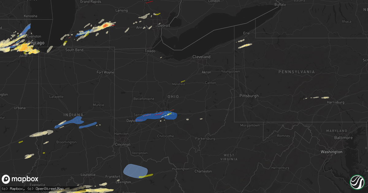
Hail Map in Ohio on February 27, 2024
Get this storm
February 27 map
$229
one time, instant access
Download today. No call, no setup
Keep the $229
Bought the map and want the full workflow? Apply the entire $229 to a subscription within 7 days. None of it is wasted.
Every map, not just this one
This buys you this map. Subscription and you get every map we run, in the markets you choose from a few cities to whole states to nationwide. Plus real-time alerts the moment a storm fires.
Contact data
Name, contact info, occupancy, even credit band for addresses in the footprint. You go from where it hit to who to call.
Become the source they trust
Unlimited branding weather history reports on demand. You already have the documented answer ready for the property owner, and you are the one who showed up with it.
Property data and RoofTrace estimates
Pull up any address you have got, its value and the exact code rules for that jurisdiction, straight from One Click Code. Then RoofTrace estimates the squares, pitch, and roof value, priced the way you price.
Storm reports in Ohio
Ohio
| Date | Description |
|---|---|
| 02/27/20245:56 AM CST | Report of trees down south of pleasant city. Time estimated based on radar. |
| 02/27/20245:42 AM CST | Em reported trees down along state route 14 east of chandlersville. Time estimated |
| 02/27/20245:42 AM CST | Em reported trees down along state route 14 east of chandlersville. Time estimated based on radar. |
| 02/27/20245:37 AM CST | Em reporting trees down near adamsville. Time estimated based on radar. |
| 02/27/20245:30 AM CST | Trees uprooted and damaged on flint ridge rd and by crooksville school. |
| 02/27/20245:30 AM CST | Em reportings trees down in roseville. Time estimated based on radar. |
| 02/27/20245:30 AM CST | A nws survey team found that strong straight line winds of 80 to 90 mph resulted in tree damage to a mixture of softwood and hardwood trees just south of crooksville. T |
| 02/27/20245:06 AM CST | Numerous trees were uprooted and several buildings were damaged at lake hudson near granville. It was determined this damage was likely caused by intense straight-line |
| 02/27/20244:57 AM CST | Barn roof damage reported. Time estimated from radar. |
| 02/27/20244:51 AM CST | Numerous live red oak trees snapped from 8-30 feet above ground. Possible tornado. Time estimated from radar. |
| 02/27/20244:51 AM CST | Damage to a home reported. Possible tornado. Time estimated from radar. |
| 02/27/20244:49 AM CST | Nws storm survey confirms an ef2 tornado developed near havens corners in franklin county and dissipated southwest of granville in licking county. Estimated winds of 12 |
| 02/27/20244:48 AM CST | A local report indicates 58 MPH wind near 2 ENE Lockbourne |
| 02/27/20244:42 AM CST | A local report indicates 1.00 inch wind near St. Clairsville |
| 02/27/20244:42 AM CST | A local report indicates 1.00 inch wind near 1 NNE Gahanna |
| 02/27/20244:40 AM CST | Semi trailer flipped over on us-23 near picway road. |
| 02/27/20244:39 AM CST | Power poles downed on state route 104. |
| 02/27/20244:31 AM CST | Possible tornado. Pine tree snapped at its base. |
| 02/27/20244:31 AM CST | A local report indicates 1.50 inch wind near 1 WNW Grove City |
| 02/27/20244:31 AM CST | A local report indicates 1.50 inch wind near 1 NNE Grove City |
| 02/27/20244:26 AM CST | Nws storm survey confirms an ef1 tornado developed west of hilliard and dissipated on the west side i-270. Maximum estimated winds of 110 mph... With damage to roofs an |
| 02/27/20244:20 AM CST | Possible tornado. Trees and wires reported down... Damage to homes on hilliard-rome rd. Time estimated from radar. |
| 02/27/20244:20 AM CST | Extensive damage to homes. Tornado likely - tds observed on kiln radar. Time estimated from radar. |
| 02/27/20244:14 AM CST | Nws storm survey confirms an ef1 tornado developed east of london and dissipated southwest of west jefferson. Maximum estimated winds of 110 mph... With damage to roofs |
| 02/27/20244:11 AM CST | Kufy awos. |
| 02/27/20244:10 AM CST | Several trees reported down. Time estimated from radar. |
| 02/27/20244:07 AM CST | Extensive damage to homes. Possible tornado. Time estimated from radar. |
| 02/27/20243:59 AM CST | 12 inch diameter tree reported down near new love rd and i-70. Time estimated from radar. |
| 02/27/20243:56 AM CST | Awos station ksgh springfield-beckley airport. |
| 02/27/20243:56 AM CST | Multiple houses damaged. Tornado likely. Tds observed on kiln radar. Time estimated from radar. |
| 02/27/20243:55 AM CST | A local report indicates 2.00 inch wind near 1 WNW Springfield |
| 02/27/20243:54 AM CST | Corrects previous tornado report from 4 se springfield. Moderate damage... Heavy debris reported on mitchell rd. Tornado likely. Tds was observed on kiln radar. Time es |
| 02/27/20243:52 AM CST | A tornado developed south of springfield... Ohio... Intensifying to ef2 strength as it progressed northeast out of clark county... Ohio and into madison county... Ohio. |
| 02/27/20243:50 AM CST | Two power poles were blown over... Several trees were uprooted and a couple homes south of town suffered minor roof damage. Estimated wind speed around 75 mph. |
| 02/27/20243:49 AM CST | Large tree down. Photo verified. Time estimated from radar. |
| 02/27/20243:37 AM CST | 3 trees reported down. A pine reported snapped near the top. Tornado likely. Tds observed on kiln radar. Time estimated from radar. |
| 02/27/20243:37 AM CST | Glass blown out at airway shopping center. Tornado likely. Tds observed on kiln radar. Time estimated from radar. |
| 02/27/20243:37 AM CST | Nws storm survey confirms an ef1 tornado developed near wright-patterson air force base and dissipated near wright state university. Estimated max wind speed was around |
| 02/27/20243:35 AM CST | Large tree fell on a house. Also... Another tree reported on a car nearby. Time estimated from radar. |
| 02/27/20243:30 AM CST | Wires down on drummer avenue. Time estimated from radar. |
| 02/27/20243:28 AM CST | Wires down on green street. Time estimated from radar. |
| 02/27/20243:25 AM CST | Corrects previous tstm wnd dmg report from 2 ene drexel. Wires down on elmer street. Time estimated from radar. |
| 02/27/20243:03 AM CST | Pole down on n. Liberty st. Time estimated from radar. |
| 02/27/20242:08 AM CST | Trees reported down. Time estimated from radar. |
| 02/27/202412:52 AM CST | A local report indicates 1.00 inch wind near 2 S Ashland |
| 02/27/202412:28 AM CST | A local report indicates 1.00 inch wind near Ontario |
| 02/26/202411:33 PM CST | A local report indicates 1.00 inch wind near 2 NE Reynoldsburg |
| 02/26/202411:21 PM CST | A local report indicates 1.00 inch wind near 2 SW Reynoldsburg |
All States Impacted by Hail Map on February 27, 2024
Cities Impacted by Hail Map on February 27, 2024
- Prophetstown, IL
- Aledo, IL
- Coal Valley, IL
- Moline, IL
- East Moline, IL
- Silvis, IL
- Colona, IL
- Tampico, IL
- Carbon Cliff, IL
- Rock Falls, IL
- Joy, IL
- Hillsdale, IL
- Sublette, IL
- Amboy, IL
- Harmon, IL
- Geneseo, IL
- Osco, IL
- Atkinson, IL
- New Windsor, IL
- Lynn Center, IL
- Dixon, IL
- West Brooklyn, IL
- Compton, IL
- Annawan, IL
- Steward, IL
- Mineral, IL
- Lee, IL
- Shabbona, IL
- Waterman, IL
- Malta, IL
- Dekalb, IL
- Sheffield, IL
- Walnut, IL
- Paw Paw, IL
- Earlville, IL
- Manlius, IL
- Somonauk, IL
- Sandwich, IL
- Hinckley, IL
- Big Rock, IL
- Sugar Grove, IL
- Leland, IL
- Plano, IL
- Aurora, IL
- North Aurora, IL
- Maple Park, IL
- Elburn, IL
- Saint Charles, IL
- Winnebago, IL
- Pecatonica, IL
- Wayne, IL
- Bartlett, IL
- Elgin, IL
- Rockford, IL
- Batavia, IL
- Geneva, IL
- West Chicago, IL
- Rockton, IL
- South Beloit, IL
- Beloit, WI
- Hoffman Estates, IL
- Barrington, IL
- Dundee, IL
- Streamwood, IL
- Palatine, IL
- Schaumburg, IL
- Hanover Park, IL
- Rolling Meadows, IL
- Lake Zurich, IL
- Oswego, IL
- Montgomery, IL
- Naperville, IL
- Arlington Heights, IL
- Mundelein, IL
- Lake Forest, IL
- Vernon Hills, IL
- Lincolnshire, IL
- Libertyville, IL
- Buffalo Grove, IL
- Plainfield, IL
- Bolingbrook, IL
- Romeoville, IL
- Lake Bluff, IL
- Great Lakes, IL
- North Chicago, IL
- Wheaton, IL
- Lisle, IL
- Glen Ellyn, IL
- Lombard, IL
- Villa Park, IL
- Lockport, IL
- Lemont, IL
- Waukegan, IL
- Homer Glen, IL
- Orland Park, IL
- Palos Park, IL
- La Grange, IL
- Western Springs, IL
- Westchester, IL
- La Grange Park, IL
- Hines, IL
- Broadview, IL
- Brookfield, IL
- Maywood, IL
- Riverside, IL
- Darien, IL
- Woodridge, IL
- Downers Grove, IL
- Forest Park, IL
- Willowbrook, IL
- Willow Springs, IL
- Palos Heights, IL
- Hinsdale, IL
- Chicago Ridge, IL
- Palos Hills, IL
- Worth, IL
- Oak Lawn, IL
- Hometown, IL
- Chicago, IL
- Tinley Park, IL
- Oak Forest, IL
- Crestwood, IL
- Midlothian, IL
- Markham, IL
- Robbins, IL
- Harvey, IL
- Posen, IL
- Blue Island, IL
- South Holland, IL
- Calumet City, IL
- Riverdale, IL
- Hammond, IN
- Dolton, IL
- Hickory Hills, IL
- Bridgeview, IL
- Justice, IL
- Burbank, IL
- Whiting, IN
- Hazel Crest, IL
- Glendale Heights, IL
- Carol Stream, IL
- Deer Grove, IL
- Warrenville, IL
- Alpha, IL
- Ophiem, IL
- Cambridge, IL
- Andover, IL
- Orion, IL
- Milan, IL
- Ohio, IL
- La Moille, IL
- Mooseheart, IL
- Medinah, IL
- Winfield, IL
- Addison, IL
- Bloomingdale, IL
- Itasca, IL
- Clarendon Hills, IL
- Oak Brook, IL
- Westmont, IL
- Sycamore, IL
- Franklin Grove, IL
- Cortland, IL
- New Boston, IL
- Elmwood Park, IL
- Yorkville, IL
- Bristol, IL
- Elmhurst, IL
- Hillside, IL
- Hampshire, IL
- Gilberts, IL
- Huntley, IL
- Lake In The Hills, IL
- Crystal Lake, IL
- Algonquin, IL
- Carpentersville, IL
- South Elgin, IL
- Sterling, IL
- Wasco, IL
- Ashton, IL
- Mount Prospect, IL
- Elk Grove Village, IL
- East Chicago, IN
- Alsip, IL
- Berrien Springs, MI
- Saint Joseph, MI
- Sodus, MI
- Sawyer, MI
- Three Oaks, MI
- Bridgman, MI
- Baroda, MI
- New Troy, MI
- Buchanan, MI
- Marcellus, MI
- Lawton, MI
- Decatur, MI
- Schoolcraft, MI
- Mattawan, MI
- Kalamazoo, MI
- Battle Creek, MI
- Bellevue, MI
- Marshall, MI
- Albion, MI
- Hidalgo, IL
- Jewett, IL
- Greenup, IL
- Columbus, OH
- Reynoldsburg, OH
- Grand Blanc, MI
- Climax, MI
- Pataskala, OH
- Davison, MI
- Goodrich, MI
- Lapeer, MI
- Mansfield, OH
- Ashland, OH
- Dowagiac, MI
- Paw Paw, MI
- Portage, MI
- Cloverdale, IN
- Greencastle, IN
- Reelsville, IN
- Coatesville, IN
- Putnamville, IN
- Fillmore, IN
- Clayton, IN
- Stilesville, IN
- Amo, IN
- Danville, IN
- Plainfield, IN
- Avon, IN
- Indianapolis, IN
- Beech Grove, IN
- New Palestine, IN
- Whiteland, IN
- Greenwood, IN
- Franklin, IN
- Boggstown, IN
- Fairland, IN
- Needham, IN
- Waterford, MI
- Pontiac, MI
- Bloomfield Hills, MI
- Keego Harbor, MI
- Auburn Hills, MI
- Rochester, MI
- Shelbyville, IN
- Oaktown, IN
- Edwardsport, IN
- Freelandville, IN
- Bicknell, IN
- Morristown, IN
- Fountaintown, IN
- Sumner, IL
- Bridgeport, IL
- Rushville, IN
- Arlington, IN
- Gwynneville, IN
- Carthage, IN
- Pinckney, MI
- Whitmore Lake, MI
- Dexter, MI
- Hartford, MI
- Benton Harbor, MI
- Watervliet, MI
- Vicksburg, MI
- Mendon, MI
- Detroit, MI
- Burlington, MI
- Tekonsha, MI
- Galesburg, MI
- Riley, IN
- Marshall, IL
- West Terre Haute, IN
- Brazil, IN
- Terre Haute, IN
- Honey Grove, PA
- East Waterford, PA
- Dowling, MI
- Delton, MI
- Hickory Corners, MI
- Augusta, MI
- Belleville, MI
- Canton, MI
- Ypsilanti, MI
- Jackson, MI
- Michigan Center, MI
- Summit Argo, IL
- Northbrook, IL
- Glencoe, IL
- Winnetka, IL
- Portage, IN
- New Bloomfield, PA
- Shermans Dale, PA
- Loysville, PA
- Elliottsburg, PA
- Landisburg, PA
- Duncannon, PA
- Ceresco, MI
- Scotts, MI
- Olivet, MI
- East Leroy, MI
- Mokena, IL
- Cassopolis, MI
- Gobles, MI
- Eau Claire, MI
- River Forest, IL
- Claremont, IL
- Lawrence, MI
- Casey, IL
- Gary, IN
- Chesterton, IN
- Chelsea, MI
- Gregory, MI
- Oak Park, IL
- Martinsville, IL
- Dennison, IL
- Staunton, IN
- Bellwood, IL
- Thornton, IL
- Stockbridge, MI
- Prospect Heights, IL
- Hawesville, KY
- Philpot, KY
- Cloverport, KY
- Reynolds Station, KY
- Hardinsburg, KY
- Whitesville, KY
- Fordsville, KY
- Falls Of Rough, KY
- Westview, KY
- Harned, KY
- Radcliff, KY
- Rineyville, KY
- Elizabethtown, KY
- Lebanon Junction, KY
- Boston, KY
- Fairborn, OH
- Xenia, OH
- Yellow Springs, OH
- Cedarville, OH
- Springfield, OH
- South Charleston, OH
- South Vienna, OH
- London, OH
- Dayton, OH
- Enon, OH
- South Solon, OH
- West Jefferson, OH
- Galloway, OH
- Mount Sterling, OH
- Grove City, OH
- Orient, OH
- Hilliard, OH
- Cynthiana, KY
- Paris, KY
- Sadieville, KY
- Georgetown, KY
- Lexington, KY
- Carlisle, KY
- Mount Olivet, KY
- Berry, KY
- Lockbourne, OH
- Millersburg, KY
- Ewing, KY
- Mayslick, KY
- Groveport, OH
- Ashville, OH
- Pickerington, OH
- Blacklick, OH
- Canal Winchester, OH
- Carroll, OH
- Lithopolis, OH
- Millersport, OH
- Etna, OH
- Baltimore, OH
- Mount Sterling, KY
- Moorefield, KY
- Sharpsburg, KY
- Wallingford, KY
- Flemingsburg, KY
- Hillsboro, KY
- Owingsville, KY
- Hebron, OH
- Kirkersville, OH
- Vine Grove, KY
- West Point, KY
- Bardstown, KY
- Springfield, KY
- Garfield, KY
- Irvington, KY
- Custer, KY
- Willisburg, KY
- Harrodsburg, KY
- Morehead, KY
- Nicholasville, KY
- Richmond, KY
- Mapleton Depot, PA
- Lewisport, KY
- Glenwood, IN
- Ickesburg, PA
- Bloomfield, KY
- Mount Eden, KY
- Lawrenceburg, KY
- Saegertown, PA
- Cambridge Springs, PA
- Waterford, PA
- Conneautville, PA
- Venango, PA
- Meadville, PA
- Brandenburg, KY
- Owensboro, KY
- Clarklake, MI
- New Carlisle, OH
- Nashville, MI
- Commerce Township, MI
- Walled Lake, MI
- Centerpoint, IN
- Union City, PA
- Hodgenville, KY
- Taylorsville, KY
- Olney, IL
- West Bloomfield, MI
- Fort Knox, KY
- Donnelsville, OH
- Cecilia, KY
- Eastview, KY
- Glendale, KY
- Brighton, MI
- Jasonville, IN
- Cory, IN
- Albion, PA
- Utica, KY
- Cranesville, PA
- Cottage Grove, TN
- McDaniels, KY
- Sullivan, IN
- Guston, KY
- Flat Rock, IL
- Edinboro, PA
- Leroy, MI
- Cadillac, MI
- Tustin, MI
- Ekron, KY
- Medway, OH
- Coxs Creek, KY
- Milford, MI
- McVeytown, PA
- Hudson, KY
- Oak Harbor, OH
- Martin, TN
- Palmersville, TN
- Dukedom, TN
- Dresden, TN
- Huntingdon, PA
- New Haven, KY
- Muldraugh, KY
- Maceo, KY
- Clermont, KY
- Shepherdsville, KY
- Webster, KY
- Howell, MI
- Highland, MI
- White Lake, MI
- Berrien Center, MI
- Springport, MI
- Charlotte, MI
- Orbisonia, PA
- McKean, PA
- Girard, PA
- Homewood, IL
- Shelburn, IN
- Leitchfield, KY
- Ann Arbor, MI
- Versailles, KY
- Cumberland, OH
- Bonnieville, KY
- Viola, IL
- Mackville, KY
- Midway, KY
- Reynolds, IL
- Dearborn Heights, MI
- South Fulton, TN
- Somerset, OH
- New Lexington, OH
- Roseville, OH
- Caldwell, OH
- Chaplin, KY
- Paris, TN
- Alexandria, OH
- Granville, OH
- Country Club Hills, IL
- Saint Clairsville, OH
- Bridgeport, OH
- Martins Ferry, OH
- Jerusalem, OH
- Woodsfield, OH
- Beallsville, OH


