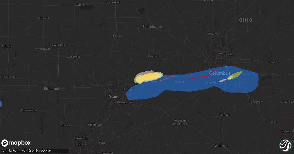
Hail Map in Springfield, OH on February 27, 2024
Get this storm
February 27 map
$229
one time, instant access
Download today. No call, no setup
Keep the $229
Bought the map and want the full workflow? Apply the entire $229 to a subscription within 7 days. None of it is wasted.
Every map, not just this one
This buys you this map. Subscription and you get every map we run, in the markets you choose from a few cities to whole states to nationwide. Plus real-time alerts the moment a storm fires.
Contact data
Name, contact info, occupancy, even credit band for addresses in the footprint. You go from where it hit to who to call.
Become the source they trust
Unlimited branding weather history reports on demand. You already have the documented answer ready for the property owner, and you are the one who showed up with it.
Property data and RoofTrace estimates
Pull up any address you have got, its value and the exact code rules for that jurisdiction, straight from One Click Code. Then RoofTrace estimates the squares, pitch, and roof value, priced the way you price.
Storm reports in Springfield, OH
Springfield, OH
| Date | Description |
|---|---|
| 02/27/20243:56 AM CST | Awos station ksgh springfield-beckley airport. |
| 02/27/20243:56 AM CST | Multiple houses damaged. Tornado likely. Tds observed on kiln radar. Time estimated from radar. |
| 02/27/20243:55 AM CST | A local report indicates 2.00 inch wind near 1 WNW Springfield |
| 02/27/20243:54 AM CST | Corrects previous tornado report from 4 se springfield. Moderate damage... Heavy debris reported on mitchell rd. Tornado likely. Tds was observed on kiln radar. Time es |
| 02/27/20243:52 AM CST | A tornado developed south of springfield... Ohio... Intensifying to ef2 strength as it progressed northeast out of clark county... Ohio and into madison county... Ohio. |
| 02/27/20243:49 AM CST | Large tree down. Photo verified. Time estimated from radar. |
All States Impacted by Hail Map on February 27, 2024
All Cities Impacted by Hail Map on February 27, 2024
- Prophetstown, IL
- Aledo, IL
- Coal Valley, IL
- Moline, IL
- East Moline, IL
- Silvis, IL
- Colona, IL
- Tampico, IL
- Carbon Cliff, IL
- Rock Falls, IL
- Joy, IL
- Hillsdale, IL
- Sublette, IL
- Amboy, IL
- Harmon, IL
- Geneseo, IL
- Osco, IL
- Atkinson, IL
- New Windsor, IL
- Lynn Center, IL
- Dixon, IL
- West Brooklyn, IL
- Compton, IL
- Annawan, IL
- Steward, IL
- Mineral, IL
- Lee, IL
- Shabbona, IL
- Waterman, IL
- Malta, IL
- Dekalb, IL
- Sheffield, IL
- Walnut, IL
- Paw Paw, IL
- Earlville, IL
- Manlius, IL
- Somonauk, IL
- Sandwich, IL
- Hinckley, IL
- Big Rock, IL
- Sugar Grove, IL
- Leland, IL
- Plano, IL
- Aurora, IL
- North Aurora, IL
- Maple Park, IL
- Elburn, IL
- Saint Charles, IL
- Winnebago, IL
- Pecatonica, IL
- Wayne, IL
- Bartlett, IL
- Elgin, IL
- Rockford, IL
- Batavia, IL
- Geneva, IL
- West Chicago, IL
- Rockton, IL
- South Beloit, IL
- Beloit, WI
- Hoffman Estates, IL
- Barrington, IL
- Dundee, IL
- Streamwood, IL
- Palatine, IL
- Schaumburg, IL
- Hanover Park, IL
- Rolling Meadows, IL
- Lake Zurich, IL
- Oswego, IL
- Montgomery, IL
- Naperville, IL
- Arlington Heights, IL
- Mundelein, IL
- Lake Forest, IL
- Vernon Hills, IL
- Lincolnshire, IL
- Libertyville, IL
- Buffalo Grove, IL
- Plainfield, IL
- Bolingbrook, IL
- Romeoville, IL
- Lake Bluff, IL
- Great Lakes, IL
- North Chicago, IL
- Wheaton, IL
- Lisle, IL
- Glen Ellyn, IL
- Lombard, IL
- Villa Park, IL
- Lockport, IL
- Lemont, IL
- Waukegan, IL
- Homer Glen, IL
- Orland Park, IL
- Palos Park, IL
- La Grange, IL
- Western Springs, IL
- Westchester, IL
- La Grange Park, IL
- Hines, IL
- Broadview, IL
- Brookfield, IL
- Maywood, IL
- Riverside, IL
- Darien, IL
- Woodridge, IL
- Downers Grove, IL
- Forest Park, IL
- Willowbrook, IL
- Willow Springs, IL
- Palos Heights, IL
- Hinsdale, IL
- Chicago Ridge, IL
- Palos Hills, IL
- Worth, IL
- Oak Lawn, IL
- Hometown, IL
- Chicago, IL
- Tinley Park, IL
- Oak Forest, IL
- Crestwood, IL
- Midlothian, IL
- Markham, IL
- Robbins, IL
- Harvey, IL
- Posen, IL
- Blue Island, IL
- South Holland, IL
- Calumet City, IL
- Riverdale, IL
- Hammond, IN
- Dolton, IL
- Hickory Hills, IL
- Bridgeview, IL
- Justice, IL
- Burbank, IL
- Whiting, IN
- Hazel Crest, IL
- Glendale Heights, IL
- Carol Stream, IL
- Deer Grove, IL
- Warrenville, IL
- Alpha, IL
- Ophiem, IL
- Cambridge, IL
- Andover, IL
- Orion, IL
- Milan, IL
- Ohio, IL
- La Moille, IL
- Mooseheart, IL
- Medinah, IL
- Winfield, IL
- Addison, IL
- Bloomingdale, IL
- Itasca, IL
- Clarendon Hills, IL
- Oak Brook, IL
- Westmont, IL
- Sycamore, IL
- Franklin Grove, IL
- Cortland, IL
- New Boston, IL
- Elmwood Park, IL
- Yorkville, IL
- Bristol, IL
- Elmhurst, IL
- Hillside, IL
- Hampshire, IL
- Gilberts, IL
- Huntley, IL
- Lake In The Hills, IL
- Crystal Lake, IL
- Algonquin, IL
- Carpentersville, IL
- South Elgin, IL
- Sterling, IL
- Wasco, IL
- Ashton, IL
- Mount Prospect, IL
- Elk Grove Village, IL
- East Chicago, IN
- Alsip, IL
- Berrien Springs, MI
- Saint Joseph, MI
- Sodus, MI
- Sawyer, MI
- Three Oaks, MI
- Bridgman, MI
- Baroda, MI
- New Troy, MI
- Buchanan, MI
- Marcellus, MI
- Lawton, MI
- Decatur, MI
- Schoolcraft, MI
- Mattawan, MI
- Kalamazoo, MI
- Battle Creek, MI
- Bellevue, MI
- Marshall, MI
- Albion, MI
- Hidalgo, IL
- Jewett, IL
- Greenup, IL
- Columbus, OH
- Reynoldsburg, OH
- Grand Blanc, MI
- Climax, MI
- Pataskala, OH
- Davison, MI
- Goodrich, MI
- Lapeer, MI
- Mansfield, OH
- Ashland, OH
- Dowagiac, MI
- Paw Paw, MI
- Portage, MI
- Cloverdale, IN
- Greencastle, IN
- Reelsville, IN
- Coatesville, IN
- Putnamville, IN
- Fillmore, IN
- Clayton, IN
- Stilesville, IN
- Amo, IN
- Danville, IN
- Plainfield, IN
- Avon, IN
- Indianapolis, IN
- Beech Grove, IN
- New Palestine, IN
- Whiteland, IN
- Greenwood, IN
- Franklin, IN
- Boggstown, IN
- Fairland, IN
- Needham, IN
- Waterford, MI
- Pontiac, MI
- Bloomfield Hills, MI
- Keego Harbor, MI
- Auburn Hills, MI
- Rochester, MI
- Shelbyville, IN
- Oaktown, IN
- Edwardsport, IN
- Freelandville, IN
- Bicknell, IN
- Morristown, IN
- Fountaintown, IN
- Sumner, IL
- Bridgeport, IL
- Rushville, IN
- Arlington, IN
- Gwynneville, IN
- Carthage, IN
- Pinckney, MI
- Whitmore Lake, MI
- Dexter, MI
- Hartford, MI
- Benton Harbor, MI
- Watervliet, MI
- Vicksburg, MI
- Mendon, MI
- Detroit, MI
- Burlington, MI
- Tekonsha, MI
- Galesburg, MI
- Riley, IN
- Marshall, IL
- West Terre Haute, IN
- Brazil, IN
- Terre Haute, IN
- Honey Grove, PA
- East Waterford, PA
- Dowling, MI
- Delton, MI
- Hickory Corners, MI
- Augusta, MI
- Belleville, MI
- Canton, MI
- Ypsilanti, MI
- Jackson, MI
- Michigan Center, MI
- Summit Argo, IL
- Northbrook, IL
- Glencoe, IL
- Winnetka, IL
- Portage, IN
- New Bloomfield, PA
- Shermans Dale, PA
- Loysville, PA
- Elliottsburg, PA
- Landisburg, PA
- Duncannon, PA
- Ceresco, MI
- Scotts, MI
- Olivet, MI
- East Leroy, MI
- Mokena, IL
- Cassopolis, MI
- Gobles, MI
- Eau Claire, MI
- River Forest, IL
- Claremont, IL
- Lawrence, MI
- Casey, IL
- Gary, IN
- Chesterton, IN
- Chelsea, MI
- Gregory, MI
- Oak Park, IL
- Martinsville, IL
- Dennison, IL
- Staunton, IN
- Bellwood, IL
- Thornton, IL
- Stockbridge, MI
- Prospect Heights, IL
- Hawesville, KY
- Philpot, KY
- Cloverport, KY
- Reynolds Station, KY
- Hardinsburg, KY
- Whitesville, KY
- Fordsville, KY
- Falls Of Rough, KY
- Westview, KY
- Harned, KY
- Radcliff, KY
- Rineyville, KY
- Elizabethtown, KY
- Lebanon Junction, KY
- Boston, KY
- Fairborn, OH
- Xenia, OH
- Yellow Springs, OH
- Cedarville, OH
- Springfield, OH
- South Charleston, OH
- South Vienna, OH
- London, OH
- Dayton, OH
- Enon, OH
- South Solon, OH
- West Jefferson, OH
- Galloway, OH
- Mount Sterling, OH
- Grove City, OH
- Orient, OH
- Hilliard, OH
- Cynthiana, KY
- Paris, KY
- Sadieville, KY
- Georgetown, KY
- Lexington, KY
- Carlisle, KY
- Mount Olivet, KY
- Berry, KY
- Lockbourne, OH
- Millersburg, KY
- Ewing, KY
- Mayslick, KY
- Groveport, OH
- Ashville, OH
- Pickerington, OH
- Blacklick, OH
- Canal Winchester, OH
- Carroll, OH
- Lithopolis, OH
- Millersport, OH
- Etna, OH
- Baltimore, OH
- Mount Sterling, KY
- Moorefield, KY
- Sharpsburg, KY
- Wallingford, KY
- Flemingsburg, KY
- Hillsboro, KY
- Owingsville, KY
- Hebron, OH
- Kirkersville, OH
- Vine Grove, KY
- West Point, KY
- Bardstown, KY
- Springfield, KY
- Garfield, KY
- Irvington, KY
- Custer, KY
- Willisburg, KY
- Harrodsburg, KY
- Morehead, KY
- Nicholasville, KY
- Richmond, KY
- Mapleton Depot, PA
- Lewisport, KY
- Glenwood, IN
- Ickesburg, PA
- Bloomfield, KY
- Mount Eden, KY
- Lawrenceburg, KY
- Saegertown, PA
- Cambridge Springs, PA
- Waterford, PA
- Conneautville, PA
- Venango, PA
- Meadville, PA
- Brandenburg, KY
- Owensboro, KY
- Clarklake, MI
- New Carlisle, OH
- Nashville, MI
- Commerce Township, MI
- Walled Lake, MI
- Centerpoint, IN
- Union City, PA
- Hodgenville, KY
- Taylorsville, KY
- Olney, IL
- West Bloomfield, MI
- Fort Knox, KY
- Donnelsville, OH
- Cecilia, KY
- Eastview, KY
- Glendale, KY
- Brighton, MI
- Jasonville, IN
- Cory, IN
- Albion, PA
- Utica, KY
- Cranesville, PA
- Cottage Grove, TN
- McDaniels, KY
- Sullivan, IN
- Guston, KY
- Flat Rock, IL
- Edinboro, PA
- Leroy, MI
- Cadillac, MI
- Tustin, MI
- Ekron, KY
- Medway, OH
- Coxs Creek, KY
- Milford, MI
- McVeytown, PA
- Hudson, KY
- Oak Harbor, OH
- Martin, TN
- Palmersville, TN
- Dukedom, TN
- Dresden, TN
- Huntingdon, PA
- New Haven, KY
- Muldraugh, KY
- Maceo, KY
- Clermont, KY
- Shepherdsville, KY
- Webster, KY
- Howell, MI
- Highland, MI
- White Lake, MI
- Berrien Center, MI
- Springport, MI
- Charlotte, MI
- Orbisonia, PA
- McKean, PA
- Girard, PA
- Homewood, IL
- Shelburn, IN
- Leitchfield, KY
- Ann Arbor, MI
- Versailles, KY
- Cumberland, OH
- Bonnieville, KY
- Viola, IL
- Mackville, KY
- Midway, KY
- Reynolds, IL
- Dearborn Heights, MI
- South Fulton, TN
- Somerset, OH
- New Lexington, OH
- Roseville, OH
- Caldwell, OH
- Chaplin, KY
- Paris, TN
- Alexandria, OH
- Granville, OH
- Country Club Hills, IL
- Saint Clairsville, OH
- Bridgeport, OH
- Martins Ferry, OH
- Jerusalem, OH
- Woodsfield, OH
- Beallsville, OH


