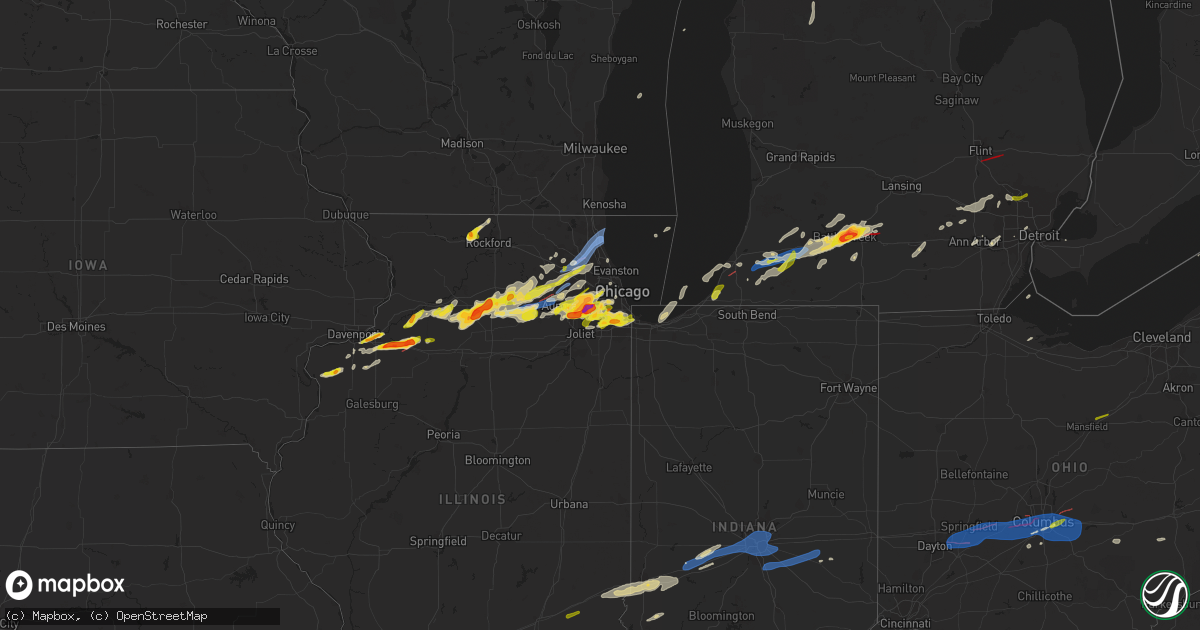
Hail Map on February 27, 2024
Get this storm
February 27 map
$229
one time, instant access
Download today. No call, no setup
Keep the $229
Bought the map and want the full workflow? Apply the entire $229 to a subscription within 7 days. None of it is wasted.
Every map, not just this one
This buys you this map. Subscription and you get every map we run, in the markets you choose from a few cities to whole states to nationwide. Plus real-time alerts the moment a storm fires.
Contact data
Name, contact info, occupancy, even credit band for addresses in the footprint. You go from where it hit to who to call.
Become the source they trust
Unlimited branding weather history reports on demand. You already have the documented answer ready for the property owner, and you are the one who showed up with it.
Property data and RoofTrace estimates
Pull up any address you have got, its value and the exact code rules for that jurisdiction, straight from One Click Code. Then RoofTrace estimates the squares, pitch, and roof value, priced the way you price.
States Impacted by Hail Map on February 27, 2024
Storm reports
Oklahoma
| Date | Description |
|---|---|
| 02/27/202411:15 AM CST | First 58 mph or greater gust at 1115 am. Peak gust at 212 pm. Final gust at 216 pm. |
Indiana
| Date | Description |
|---|---|
| 02/27/20242:40 AM CST | Small trees reported down. Time estimated from radar. |
| 02/27/20242:30 AM CST | Tree down near the intersection of reed road and east state blvd. Time estimated from radar. |
| 02/27/20242:17 AM CST | Late report of a tree split apart by thunderstorm winds. Time estimated via radar imagery. |
| 02/27/20242:08 AM CST | Several large tree limbs snapped across us40. Time estimated from radar. |
| 02/27/20241:58 AM CST | Delayed report. Numerous trees down. Trees looked relatively healthy in the pictures. Time estimated by radar. |
| 02/27/20241:53 AM CST | A local report indicates 59 MPH wind near 3 ESE Fairland |
| 02/27/20241:50 AM CST | 2-inch diameter tree limbs down. |
| 02/27/20241:39 AM CST | Relayed via social media. Time estimated from radar. |
| 02/27/20241:32 AM CST | A local report indicates 60 MPH wind near 1 SW Lawrence |
| 02/27/20241:28 AM CST | Report from mping... 3-inch tree limbs broken. |
| 02/27/20241:25 AM CST | Late report of a billboard uprooted or blown over a quarter mile east of the intersection of us 35 and sr 19 between kokomo and greentown. |
| 02/27/20241:23 AM CST | A couple gusts estimated at or above 60 mph. |
| 02/27/20241:19 AM CST | A local report indicates 59 MPH wind near Indianapolis Int'l Airp |
| 02/27/20241:10 AM CST | Late report of large portions of numerous pine trees snapped off or altogether uprooted. |
| 02/27/20241:09 AM CST | A local report indicates 60 MPH wind near 3 E Avon |
| 02/27/202412:45 AM CST | Tree down across the road on cr 1000 south west of sr 243. |
| 02/27/202412:38 AM CST | Late report of a 22-foot coleman pool that was lifted and caved in in centerpoint indiana. |
| 02/27/202412:20 AM CST | Reported through amateur radio. |
| 02/26/20249:15 PM CST | An nws damage survey confirmed that an ef-1 tornado with estimated peak winds of 90 mph... A path length of 2.2 miles on land... And a maximum width of 75 yards impacte |
Kentucky
| Date | Description |
|---|---|
| 02/27/20245:55 AM CST | Power lines down on fourth street. |
| 02/27/20245:47 AM CST | Tree down on gap knob road. |
| 02/27/20245:45 AM CST | Em passed along security camera footage of what looks like quarter sized hail falling. |
| 02/27/20245:40 AM CST | A local report indicates 1.00 inch wind near Willisburg |
| 02/27/20245:38 AM CST | Delayed report. Several power poles down on mccracken pike. |
| 02/27/20245:29 AM CST | A tree was blown down and took down a power line at 155 mckenzie road. |
| 02/27/20245:23 AM CST | A local report indicates 1.00 inch wind near 1 ESE Nazareth |
| 02/27/20245:22 AM CST | Tree down on 1000 block of dry creek road. |
| 02/27/20245:19 AM CST | Tree down on bear creek road. |
| 02/27/20245:18 AM CST | Trees down on new haven road. |
| 02/27/20245:18 AM CST | Trees down near bluegrass parkway. |
| 02/27/20245:14 AM CST | Utility pole down across n broadway. |
| 02/27/20245:07 AM CST | A barn was blown down along white oak rd. Approximately 1 mile from wyoming rd. |
| 02/27/20245:00 AM CST | Tree down on mattox street. |
| 02/27/20244:54 AM CST | A local report indicates 1.00 inch wind near Lawrenceburg |
| 02/27/20244:52 AM CST | Report from mping: quarter |
| 02/27/20244:50 AM CST | Off duty nws employee measured 1.25 inch hail. |
| 02/27/20244:50 AM CST | A local report indicates 1.25 inch wind near 3 SE Radcliff |
| 02/27/20244:48 AM CST | Report from mping: quarter |
| 02/27/20244:47 AM CST | Tree down on old paris road. |
| 02/27/20244:45 AM CST | A local report indicates 1.25 inch wind near 1 N Mcquady |
| 02/27/20244:35 AM CST | Trees down on escordida road near paris. |
| 02/27/20244:20 AM CST | Large tree limb down and blocking one lane of ky highway 1842 north. |
| 02/27/20244:17 AM CST | Corrects previous hail report time from 1 n mcquady. |
| 02/27/20244:15 AM CST | Two barns destroyed... Fence damage. |
| 02/27/20244:00 AM CST | A local report indicates 61 MPH wind near 1 S Kelat |
| 02/27/20243:38 AM CST | Report from mping: quarter |
| 02/27/20243:29 AM CST | A local report indicates 1.25 inch wind near 4 ENE Rineyville |
| 02/27/20243:25 AM CST | A local report indicates 1.75 inch wind near Rineyville |
| 02/27/20243:23 AM CST | Tree down on highway 105 near cloverport. |
| 02/27/20242:55 AM CST | A local report indicates 1.25 inch wind near Mcquady |
| 02/27/20242:53 AM CST | Investigating roof damage to a home in robards. |
| 02/27/20242:47 AM CST | Delayed report of quarter size hail in easton. |
| 02/27/20242:40 AM CST | Large tree down. |
| 02/27/20242:23 AM CST | Corrects previous tstm wnd dmg report time from cloverport. Tree down on highway 105. |
| 02/27/20242:12 AM CST | Tree down on garage. |
| 02/27/20242:12 AM CST | Delayed report of a large tree down on a garage. |
| 02/27/20242:02 AM CST | Near us 60 bypass in owensboro. |
Texas
| Date | Description |
|---|---|
| 02/27/202412:15 PM CST | A local report indicates 60 MPH wind near 3 W Dumas |
| 02/27/202411:30 AM CST | First 58 mph or greater gust at 11:30 am. Peak gust of 64 mph at 12:48 pm. Last gust so far at 2:51 pm. |
| 02/27/202410:53 AM CST | First 58 mph or greater gust at 1053 am. Peak gust at 1111 am. Last gust at 1210 pm. |
Tennessee
| Date | Description |
|---|---|
| 02/27/20245:00 AM CST | Tree and roof damage reported by em. |
Michigan
| Date | Description |
|---|---|
| 02/27/20241:14 AM CST | Most hail ranging from 0.5 to 0.75 inch with the largest stones up to an inch. |
| 02/27/202412:14 AM CST | Law enforcement reports homes and buildings damaged... Numerous downed trees and power lines in grand blanc. The intersection of dort hwy and reid rd is closed due to b |
| 02/26/202411:35 PM CST | 911 center director... Trained spotters... And radar confirmation. |
| 02/26/202411:29 PM CST | 911 center director... Trained spotters... And radar confirmation. Nws storm survey determined an ef1 rating. Hundreds of trees were snapped or uprooted along the path. |
| 02/26/202411:25 PM CST | A local report indicates 1.75 inch wind near 1 SE Brownlee Park |
| 02/26/202411:25 PM CST | A local report indicates 1.00 inch wind near 1 SE Brownlee Park |
| 02/26/202411:25 PM CST | Measured hail diameter of 2.4 inches. |
| 02/26/202411:20 PM CST | Hail covering ground with largest being at least quarter size. |
| 02/26/202411:20 PM CST | A local report indicates 1.75 inch wind near 1 SSE Battle Creek |
| 02/26/202411:15 PM CST | A local report indicates 1.25 inch wind near 4 SSW Springfield |
| 02/26/202411:01 PM CST | A local report indicates 1.00 inch wind near 2 SE Ypsilanti |
| 02/26/202410:26 PM CST | Healthy trees and power lines down on county road 669 just north of 79th street. |
| 02/26/202410:20 PM CST | Quarter sized hail... Wind gusts to 70 mph. Persistent wall cloud... And a brief funnel cloud observed. |
| 02/26/20249:36 PM CST | Report from mping: quarter |
| 02/26/20248:55 PM CST | Hail lasted about 5 minutes. |
Ohio
| Date | Description |
|---|---|
| 02/27/20245:56 AM CST | Report of trees down south of pleasant city. Time estimated based on radar. |
| 02/27/20245:42 AM CST | Em reported trees down along state route 14 east of chandlersville. Time estimated based on radar. |
| 02/27/20245:42 AM CST | Em reported trees down along state route 14 east of chandlersville. Time estimated |
| 02/27/20245:37 AM CST | Em reporting trees down near adamsville. Time estimated based on radar. |
| 02/27/20245:30 AM CST | Trees uprooted and damaged on flint ridge rd and by crooksville school. |
| 02/27/20245:30 AM CST | Em reportings trees down in roseville. Time estimated based on radar. |
| 02/27/20245:30 AM CST | A nws survey team found that strong straight line winds of 80 to 90 mph resulted in tree damage to a mixture of softwood and hardwood trees just south of crooksville. T |
| 02/27/20245:06 AM CST | Numerous trees were uprooted and several buildings were damaged at lake hudson near granville. It was determined this damage was likely caused by intense straight-line |
| 02/27/20244:57 AM CST | Barn roof damage reported. Time estimated from radar. |
| 02/27/20244:51 AM CST | Numerous live red oak trees snapped from 8-30 feet above ground. Possible tornado. Time estimated from radar. |
| 02/27/20244:51 AM CST | Damage to a home reported. Possible tornado. Time estimated from radar. |
| 02/27/20244:49 AM CST | Nws storm survey confirms an ef2 tornado developed near havens corners in franklin county and dissipated southwest of granville in licking county. Estimated winds of 12 |
| 02/27/20244:48 AM CST | A local report indicates 58 MPH wind near 2 ENE Lockbourne |
| 02/27/20244:42 AM CST | A local report indicates 1.00 inch wind near 1 NNE Gahanna |
| 02/27/20244:42 AM CST | A local report indicates 1.00 inch wind near St. Clairsville |
| 02/27/20244:40 AM CST | Semi trailer flipped over on us-23 near picway road. |
| 02/27/20244:39 AM CST | Power poles downed on state route 104. |
| 02/27/20244:31 AM CST | A local report indicates 1.50 inch wind near 1 NNE Grove City |
| 02/27/20244:31 AM CST | A local report indicates 1.50 inch wind near 1 WNW Grove City |
| 02/27/20244:31 AM CST | Possible tornado. Pine tree snapped at its base. |
| 02/27/20244:26 AM CST | Nws storm survey confirms an ef1 tornado developed west of hilliard and dissipated on the west side i-270. Maximum estimated winds of 110 mph... With damage to roofs an |
| 02/27/20244:20 AM CST | Possible tornado. Trees and wires reported down... Damage to homes on hilliard-rome rd. Time estimated from radar. |
| 02/27/20244:20 AM CST | Extensive damage to homes. Tornado likely - tds observed on kiln radar. Time estimated from radar. |
| 02/27/20244:14 AM CST | Nws storm survey confirms an ef1 tornado developed east of london and dissipated southwest of west jefferson. Maximum estimated winds of 110 mph... With damage to roofs |
| 02/27/20244:11 AM CST | Kufy awos. |
| 02/27/20244:10 AM CST | Several trees reported down. Time estimated from radar. |
| 02/27/20244:07 AM CST | Extensive damage to homes. Possible tornado. Time estimated from radar. |
| 02/27/20243:59 AM CST | 12 inch diameter tree reported down near new love rd and i-70. Time estimated from radar. |
| 02/27/20243:56 AM CST | Awos station ksgh springfield-beckley airport. |
| 02/27/20243:56 AM CST | Multiple houses damaged. Tornado likely. Tds observed on kiln radar. Time estimated from radar. |
| 02/27/20243:55 AM CST | A local report indicates 2.00 inch wind near 1 WNW Springfield |
| 02/27/20243:54 AM CST | Corrects previous tornado report from 4 se springfield. Moderate damage... Heavy debris reported on mitchell rd. Tornado likely. Tds was observed on kiln radar. Time es |
| 02/27/20243:52 AM CST | A tornado developed south of springfield... Ohio... Intensifying to ef2 strength as it progressed northeast out of clark county... Ohio and into madison county... Ohio. |
| 02/27/20243:50 AM CST | Two power poles were blown over... Several trees were uprooted and a couple homes south of town suffered minor roof damage. Estimated wind speed around 75 mph. |
| 02/27/20243:49 AM CST | Large tree down. Photo verified. Time estimated from radar. |
| 02/27/20243:37 AM CST | Nws storm survey confirms an ef1 tornado developed near wright-patterson air force base and dissipated near wright state university. Estimated max wind speed was around |
| 02/27/20243:37 AM CST | Glass blown out at airway shopping center. Tornado likely. Tds observed on kiln radar. Time estimated from radar. |
| 02/27/20243:37 AM CST | 3 trees reported down. A pine reported snapped near the top. Tornado likely. Tds observed on kiln radar. Time estimated from radar. |
| 02/27/20243:35 AM CST | Large tree fell on a house. Also... Another tree reported on a car nearby. Time estimated from radar. |
| 02/27/20243:30 AM CST | Wires down on drummer avenue. Time estimated from radar. |
| 02/27/20243:28 AM CST | Wires down on green street. Time estimated from radar. |
| 02/27/20243:25 AM CST | Corrects previous tstm wnd dmg report from 2 ene drexel. Wires down on elmer street. Time estimated from radar. |
| 02/27/20243:03 AM CST | Pole down on n. Liberty st. Time estimated from radar. |
| 02/27/20242:08 AM CST | Trees reported down. Time estimated from radar. |
| 02/27/202412:52 AM CST | A local report indicates 1.00 inch wind near 2 S Ashland |
| 02/27/202412:28 AM CST | A local report indicates 1.00 inch wind near Ontario |
| 02/26/202411:33 PM CST | A local report indicates 1.00 inch wind near 2 NE Reynoldsburg |
| 02/26/202411:21 PM CST | A local report indicates 1.00 inch wind near 2 SW Reynoldsburg |
Illinois
| Date | Description |
|---|---|
| 02/27/20245:57 PM CST | Ping pong ball sized hail. |
| 02/27/20245:56 PM CST | A high end ef1 tornado formed about 4 miles west of annawan... Il at 556 pm. The tornado initially caused damage to tree limbs before intensifying as it approached high |
| 02/27/20245:56 PM CST | A high end ef1 tornado formed about 4 miles west of annawan... Il at 656 pm. The tornado initially caused damage to tree limbs before intensifying as it approached high |
| 02/27/20245:53 PM CST | A local report indicates a tornado near 3 SW Atkinson |
| 02/27/20245:45 PM CST | Ham radio relay from a spotter. |
| 02/27/20245:40 PM CST | A local report indicates 1.25 inch wind near 1 SSE Geneseo |
| 02/27/20245:38 PM CST | Time estimated from radar. |
| 02/27/20245:28 PM CST | Relayed via mping. |
| 02/27/20245:28 PM CST | Reported hail ranging between the size of a dollar coin and a half dollar. |
| 02/27/20245:15 PM CST | A local report indicates 1.00 inch wind near Colona |
| 02/27/20245:12 PM CST | Social media picture of quarter size hail relayed by media. |
| 02/27/20245:00 PM CST | Delayed report. |
| 02/27/20245:00 PM CST | A local report indicates 1.00 inch wind near 2 N Leon Corners |
| 02/27/20241:12 AM CST | Near red hills state park. Relayed by lawrence co. Ema. |
| 02/26/20248:46 PM CST | Relayed via mping. Time estimated by radar. |
| 02/26/20248:45 PM CST | Trained spotter reports hail up to ping pong ball sized near 155th and long avenue in oak forest. Hail occurred from 840pm to 852pm. |
| 02/26/20248:37 PM CST | Photo relayed by kane county ema shows hail approximately half dollar sized near 162nd street and 88th avenue in orland park. Time estimated by radar. |
| 02/26/20248:37 PM CST | Photo relayed by kane county ema shows hai |
| 02/26/20248:36 PM CST | Relayed via mping. Time estimated by radar. |
| 02/26/20248:36 PM CST | Relayed via mping. Time estimated by radar. |
| 02/26/20248:30 PM CST | Quarter size hail from 830pm to 835pm. Peak wind 41 mph. |
| 02/26/20248:13 PM CST | Relayed via mping. Time estimated by radar. |
| 02/26/20248:13 PM CST | Rel |
| 02/26/20248:12 PM CST | A local report indicates 1.00 inch wind near Homer Glen |
| 02/26/20248:11 PM CST | A local report indicates 1.00 inch wind near Lockport |
| 02/26/20248:10 PM CST | Relayed via mping. Time estimated by radar. |
| 02/26/20248:09 PM CST | Nws employee observed quarter sized hail in lockport. Time estimated by radar. |
| 02/26/20248:09 PM CST | Relayed via mping. Time estimated by radar. |
| 02/26/20248:09 PM CST | Relayed via mping. Time estimated by radar. (lot |
| 02/26/20248:06 PM CST | Relayed via mping. Time estimated by radar. |
| 02/26/20248:01 PM CST | Public report of half dollar sized hail in eastern bolingbrook. Time estimated by radar. |
| 02/26/20248:00 PM CST | Quarter sized hail reported in south downers grove. |
| 02/26/20248:00 PM CST | Photo shared via social media shows hail up to hen egg size between downers grove and darien. Time estimated by radar. |
| 02/26/20247:57 PM CST | Photo shared via broadcast media showed golf ball sized hail in north romeoville. Time estimated by radar. |
| 02/26/20247:56 PM CST | Nickel to quarter size hail near washington and 87th. |
| 02/26/20247:55 PM CST | *** 1 inj *** an nws damage survey confirmed that a brief ef-1 tornado with estimated peak winds of 110 mph impacted mundelein... Where it removed a portion of an apart |
| 02/26/20247:52 PM CST | Social media report and photos of snapped softwood trees. Time estimated by radar. |
| 02/26/20247:51 PM CST | Will county ema reported hail up to quarter sized in west bolingbrook. Time estimated by radar. |
| 02/26/20247:50 PM CST | A local report indicates 1.50 inch wind near 3 N Plainfield |
| 02/26/20247:49 PM CST | Quarter sized hail near 87th street and naper boulevard in naperville. Time estimated by radar. |
| 02/26/20247:49 PM CST | Private weather station kilpalat112 reported 82 mph gust northwest of palatine. |
| 02/26/20247:47 PM CST | Nws employee reports hail up to 1.5 inch diameter in plainfield. Time estimated by radar. |
| 02/26/20247:40 PM CST | Private weather station kilpalat43 reported 62 mph gust near hoffman estates. |
| 02/26/20247:39 PM CST | Private weather station kilpalat92 reported a 65 mph gust near palatine. |
| 02/26/20247:38 PM CST | Estimated quarter size hail near eola and ogden. |
| 02/26/20247:37 PM CST | Damage to roof of house and gazebo near freeman road and huntington boulevard in hoffman estates. Possible tornado. Time estimated by radar. |
| 02/26/20247:36 PM CST | Report of a possible tornado north of i-90 in schaumburg. Time estimated by radar. |
| 02/26/20247:36 PM CST | An nws damage survey confirmed that an ef-1 tornado with estimated peak winds of 90 mph... A path length of 0.4 miles... And a maximum width of 100 yards impacted the n |
| 02/26/20247:34 PM CST | Relayed via mping. Time estimated by radar. |
| 02/26/20247:33 PM CST | An nws damage survey confirmed that an ef-0 tornado with estimated peak winds of 85 mph... A path length of 1.1 miles... And a maximum width of 105 yards impacted south |
| 02/26/20247:32 PM CST | An nws damage survey confirmed that an ef-0 tornado with estimated peak winds of 80 mph... A path length of 0.7 miles... And a maximum width of 100 yards impacted hoffm |
| 02/26/20247:30 PM CST | Relayed via mping. Time estimated by radar. |
| 02/26/20247:26 PM CST | A local report indicates 1.50 inch wind near 3 ENE Pecatonica |
| 02/26/20247:24 PM CST | Measured gust to 53 knots at kdpa. |
| 02/26/20247:17 PM CST | An nws damage survey confirmed that an ef-1 tornado with estimated peak winds of 95 mph... A path length of 0.9 miles... And a maximum width of 125 yards impacted the w |
| 02/26/20247:15 PM CST | Mobile office trailer within a construction site in the jewell osco parking lot flipped on its side. Shopping cart corrals also blown around. |
| 02/26/20247:06 PM CST | An nws damage survey confirmed that an ef-1 tornado with estimated peak winds of 95 mph... A path length of 8.2 miles... And a maximum width of 125 yards tracked from s |
| 02/26/20247:06 PM CST | Relayed via mping. |
| 02/26/20247:05 PM CST | Relayed via mping. Time estimated by radar. |
| 02/26/20247:05 PM CST | Reports of damage to trees... Power poles... And fencing at waubonsee community college likely associated with a tornado. |
| 02/26/20247:05 PM CST | Peak gust 55 knots at karr. |
| 02/26/20247:01 PM CST | Near intersection of council rd and suydam rd. |
| 02/26/20246:58 PM CST | An nws damage survey confirmed that an ef-0 tornado with estimated peak winds of 80 mph... A path length of 5.9 miles... And a maximum width of 125 yards touched down b |
| 02/26/20246:57 PM CST | Photo shared of a tornado near hinckley. |
| 02/26/20246:54 PM CST | An nws damage survey confirmed that an ef-0 tornado with estimated peak winds of 85 mph... A path length of 4.8 miles... And a maximum width of 175 yards touched down s |
| 02/26/20246:52 PM CST | Public report of quarter sized hail in huntley. |
| 02/26/20246:30 PM CST | Corrects previous tornado report from 2 ne waterman. Trained spotter reports a tornado on the ground 2 miles northeast of waterman. |
| 02/26/20246:30 PM CST | An nws damage survey confirmed that a brief ef-0 tornado with estimated peak winds of 65 mph touched down northeast of waterman and caused minor damage to a farmstead. |
| 02/26/20246:16 PM CST | Photo of estimated golf ball size hail. Time estimated. |
| 02/26/20246:15 PM CST | An nws damage survey confirmed that a brief ef-0 tornado with estimated peak winds of 70 mph touched down northeast of compton and caused roof damage to a farm outbuild |
| 02/26/20246:09 PM CST | Semi truck rollover on interstate 80 at mile marker 31.5. Possible tornado damage. |
| 02/26/20246:06 PM CST | Relayed via ham radio operator. At least golf ball sized hail. |
| 02/26/20246:05 PM CST | Delayed report via social media with pictures. |
| 02/26/20246:01 PM CST | Corrects previous tstm wnd dmg report from 2 nw annawan. Semi truck rollover on interstate 80 at mile marker 31.5. Possible tornado damage. Time estimated from radar. |
| 02/26/20246:00 PM CST | Via social media pictures. |
Cities Impacted by Hail Map on February 27, 2024
- Prophetstown, IL
- Aledo, IL
- Coal Valley, IL
- Moline, IL
- East Moline, IL
- Silvis, IL
- Colona, IL
- Tampico, IL
- Carbon Cliff, IL
- Rock Falls, IL
- Joy, IL
- Hillsdale, IL
- Sublette, IL
- Amboy, IL
- Harmon, IL
- Geneseo, IL
- Osco, IL
- Atkinson, IL
- New Windsor, IL
- Lynn Center, IL
- Dixon, IL
- West Brooklyn, IL
- Compton, IL
- Annawan, IL
- Steward, IL
- Mineral, IL
- Lee, IL
- Shabbona, IL
- Waterman, IL
- Malta, IL
- Dekalb, IL
- Sheffield, IL
- Walnut, IL
- Paw Paw, IL
- Earlville, IL
- Manlius, IL
- Somonauk, IL
- Sandwich, IL
- Hinckley, IL
- Big Rock, IL
- Sugar Grove, IL
- Leland, IL
- Plano, IL
- Aurora, IL
- North Aurora, IL
- Maple Park, IL
- Elburn, IL
- Saint Charles, IL
- Winnebago, IL
- Pecatonica, IL
- Wayne, IL
- Bartlett, IL
- Elgin, IL
- Rockford, IL
- Batavia, IL
- Geneva, IL
- West Chicago, IL
- Rockton, IL
- South Beloit, IL
- Beloit, WI
- Hoffman Estates, IL
- Barrington, IL
- Dundee, IL
- Streamwood, IL
- Palatine, IL
- Schaumburg, IL
- Hanover Park, IL
- Rolling Meadows, IL
- Lake Zurich, IL
- Oswego, IL
- Montgomery, IL
- Naperville, IL
- Arlington Heights, IL
- Mundelein, IL
- Lake Forest, IL
- Vernon Hills, IL
- Lincolnshire, IL
- Libertyville, IL
- Buffalo Grove, IL
- Plainfield, IL
- Bolingbrook, IL
- Romeoville, IL
- Lake Bluff, IL
- Great Lakes, IL
- North Chicago, IL
- Wheaton, IL
- Lisle, IL
- Glen Ellyn, IL
- Lombard, IL
- Villa Park, IL
- Lockport, IL
- Lemont, IL
- Waukegan, IL
- Homer Glen, IL
- Orland Park, IL
- Palos Park, IL
- La Grange, IL
- Western Springs, IL
- Westchester, IL
- La Grange Park, IL
- Hines, IL
- Broadview, IL
- Brookfield, IL
- Maywood, IL
- Riverside, IL
- Darien, IL
- Woodridge, IL
- Downers Grove, IL
- Forest Park, IL
- Willowbrook, IL
- Willow Springs, IL
- Palos Heights, IL
- Hinsdale, IL
- Chicago Ridge, IL
- Palos Hills, IL
- Worth, IL
- Oak Lawn, IL
- Hometown, IL
- Chicago, IL
- Tinley Park, IL
- Oak Forest, IL
- Crestwood, IL
- Midlothian, IL
- Markham, IL
- Robbins, IL
- Harvey, IL
- Posen, IL
- Blue Island, IL
- South Holland, IL
- Calumet City, IL
- Riverdale, IL
- Hammond, IN
- Dolton, IL
- Hickory Hills, IL
- Bridgeview, IL
- Justice, IL
- Burbank, IL
- Whiting, IN
- Hazel Crest, IL
- Glendale Heights, IL
- Carol Stream, IL
- Deer Grove, IL
- Warrenville, IL
- Alpha, IL
- Ophiem, IL
- Cambridge, IL
- Andover, IL
- Orion, IL
- Milan, IL
- Ohio, IL
- La Moille, IL
- Mooseheart, IL
- Medinah, IL
- Winfield, IL
- Addison, IL
- Bloomingdale, IL
- Itasca, IL
- Clarendon Hills, IL
- Oak Brook, IL
- Westmont, IL
- Sycamore, IL
- Franklin Grove, IL
- Cortland, IL
- New Boston, IL
- Elmwood Park, IL
- Yorkville, IL
- Bristol, IL
- Elmhurst, IL
- Hillside, IL
- Hampshire, IL
- Gilberts, IL
- Huntley, IL
- Lake In The Hills, IL
- Crystal Lake, IL
- Algonquin, IL
- Carpentersville, IL
- South Elgin, IL
- Sterling, IL
- Wasco, IL
- Ashton, IL
- Mount Prospect, IL
- Elk Grove Village, IL
- East Chicago, IN
- Alsip, IL
- Berrien Springs, MI
- Saint Joseph, MI
- Sodus, MI
- Sawyer, MI
- Three Oaks, MI
- Bridgman, MI
- Baroda, MI
- New Troy, MI
- Buchanan, MI
- Marcellus, MI
- Lawton, MI
- Decatur, MI
- Schoolcraft, MI
- Mattawan, MI
- Kalamazoo, MI
- Battle Creek, MI
- Bellevue, MI
- Marshall, MI
- Albion, MI
- Hidalgo, IL
- Jewett, IL
- Greenup, IL
- Columbus, OH
- Reynoldsburg, OH
- Grand Blanc, MI
- Climax, MI
- Pataskala, OH
- Davison, MI
- Goodrich, MI
- Lapeer, MI
- Mansfield, OH
- Ashland, OH
- Dowagiac, MI
- Paw Paw, MI
- Portage, MI
- Cloverdale, IN
- Greencastle, IN
- Reelsville, IN
- Coatesville, IN
- Putnamville, IN
- Fillmore, IN
- Clayton, IN
- Stilesville, IN
- Amo, IN
- Danville, IN
- Plainfield, IN
- Avon, IN
- Indianapolis, IN
- Beech Grove, IN
- New Palestine, IN
- Whiteland, IN
- Greenwood, IN
- Franklin, IN
- Boggstown, IN
- Fairland, IN
- Needham, IN
- Waterford, MI
- Pontiac, MI
- Bloomfield Hills, MI
- Keego Harbor, MI
- Auburn Hills, MI
- Rochester, MI
- Shelbyville, IN
- Oaktown, IN
- Edwardsport, IN
- Freelandville, IN
- Bicknell, IN
- Morristown, IN
- Fountaintown, IN
- Sumner, IL
- Bridgeport, IL
- Rushville, IN
- Arlington, IN
- Gwynneville, IN
- Carthage, IN
- Pinckney, MI
- Whitmore Lake, MI
- Dexter, MI
- Hartford, MI
- Benton Harbor, MI
- Watervliet, MI
- Vicksburg, MI
- Mendon, MI
- Detroit, MI
- Burlington, MI
- Tekonsha, MI
- Galesburg, MI
- Riley, IN
- Marshall, IL
- West Terre Haute, IN
- Brazil, IN
- Terre Haute, IN
- Honey Grove, PA
- East Waterford, PA
- Dowling, MI
- Delton, MI
- Hickory Corners, MI
- Augusta, MI
- Belleville, MI
- Canton, MI
- Ypsilanti, MI
- Jackson, MI
- Michigan Center, MI
- Summit Argo, IL
- Northbrook, IL
- Glencoe, IL
- Winnetka, IL
- Portage, IN
- New Bloomfield, PA
- Shermans Dale, PA
- Loysville, PA
- Elliottsburg, PA
- Landisburg, PA
- Duncannon, PA
- Ceresco, MI
- Scotts, MI
- Olivet, MI
- East Leroy, MI
- Mokena, IL
- Cassopolis, MI
- Gobles, MI
- Eau Claire, MI
- River Forest, IL
- Claremont, IL
- Lawrence, MI
- Casey, IL
- Gary, IN
- Chesterton, IN
- Chelsea, MI
- Gregory, MI
- Oak Park, IL
- Martinsville, IL
- Dennison, IL
- Staunton, IN
- Bellwood, IL
- Thornton, IL
- Stockbridge, MI
- Prospect Heights, IL
- Hawesville, KY
- Philpot, KY
- Cloverport, KY
- Reynolds Station, KY
- Hardinsburg, KY
- Whitesville, KY
- Fordsville, KY
- Falls Of Rough, KY
- Westview, KY
- Harned, KY
- Radcliff, KY
- Rineyville, KY
- Elizabethtown, KY
- Lebanon Junction, KY
- Boston, KY
- Fairborn, OH
- Xenia, OH
- Yellow Springs, OH
- Cedarville, OH
- Springfield, OH
- South Charleston, OH
- South Vienna, OH
- London, OH
- Dayton, OH
- Enon, OH
- South Solon, OH
- West Jefferson, OH
- Galloway, OH
- Mount Sterling, OH
- Grove City, OH
- Orient, OH
- Hilliard, OH
- Cynthiana, KY
- Paris, KY
- Sadieville, KY
- Georgetown, KY
- Lexington, KY
- Carlisle, KY
- Mount Olivet, KY
- Berry, KY
- Lockbourne, OH
- Millersburg, KY
- Ewing, KY
- Mayslick, KY
- Groveport, OH
- Ashville, OH
- Pickerington, OH
- Blacklick, OH
- Canal Winchester, OH
- Carroll, OH
- Lithopolis, OH
- Millersport, OH
- Etna, OH
- Baltimore, OH
- Mount Sterling, KY
- Moorefield, KY
- Sharpsburg, KY
- Wallingford, KY
- Flemingsburg, KY
- Hillsboro, KY
- Owingsville, KY
- Hebron, OH
- Kirkersville, OH
- Vine Grove, KY
- West Point, KY
- Bardstown, KY
- Springfield, KY
- Garfield, KY
- Irvington, KY
- Custer, KY
- Willisburg, KY
- Harrodsburg, KY
- Morehead, KY
- Nicholasville, KY
- Richmond, KY
- Mapleton Depot, PA
- Lewisport, KY
- Glenwood, IN
- Ickesburg, PA
- Bloomfield, KY
- Mount Eden, KY
- Lawrenceburg, KY
- Saegertown, PA
- Cambridge Springs, PA
- Waterford, PA
- Conneautville, PA
- Venango, PA
- Meadville, PA
- Brandenburg, KY
- Owensboro, KY
- Clarklake, MI
- New Carlisle, OH
- Nashville, MI
- Commerce Township, MI
- Walled Lake, MI
- Centerpoint, IN
- Union City, PA
- Hodgenville, KY
- Taylorsville, KY
- Olney, IL
- West Bloomfield, MI
- Fort Knox, KY
- Donnelsville, OH
- Cecilia, KY
- Eastview, KY
- Glendale, KY
- Brighton, MI
- Jasonville, IN
- Cory, IN
- Albion, PA
- Utica, KY
- Cranesville, PA
- Cottage Grove, TN
- McDaniels, KY
- Sullivan, IN
- Guston, KY
- Flat Rock, IL
- Edinboro, PA
- Leroy, MI
- Cadillac, MI
- Tustin, MI
- Ekron, KY
- Medway, OH
- Coxs Creek, KY
- Milford, MI
- McVeytown, PA
- Hudson, KY
- Oak Harbor, OH
- Martin, TN
- Palmersville, TN
- Dukedom, TN
- Dresden, TN
- Huntingdon, PA
- New Haven, KY
- Muldraugh, KY
- Maceo, KY
- Clermont, KY
- Shepherdsville, KY
- Webster, KY
- Howell, MI
- Highland, MI
- White Lake, MI
- Berrien Center, MI
- Springport, MI
- Charlotte, MI
- Orbisonia, PA
- McKean, PA
- Girard, PA
- Homewood, IL
- Shelburn, IN
- Leitchfield, KY
- Ann Arbor, MI
- Versailles, KY
- Cumberland, OH
- Bonnieville, KY
- Viola, IL
- Mackville, KY
- Midway, KY
- Reynolds, IL
- Dearborn Heights, MI
- South Fulton, TN
- Somerset, OH
- New Lexington, OH
- Roseville, OH
- Caldwell, OH
- Chaplin, KY
- Paris, TN
- Alexandria, OH
- Granville, OH
- Country Club Hills, IL
- Saint Clairsville, OH
- Bridgeport, OH
- Martins Ferry, OH
- Jerusalem, OH
- Woodsfield, OH
- Beallsville, OH