Hail Map in Georgia on February 18, 2012
Get this storm
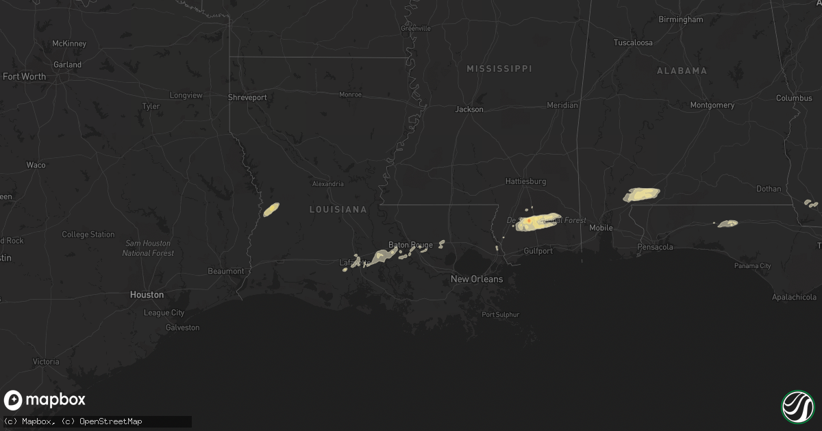
February 18 map
$229
one time, instant access
Download today. No call, no setup
Keep the $229
Bought the map and want the full workflow? Apply the entire $229 to a subscription within 7 days. None of it is wasted.
Every map, not just this one
This buys you this map. Subscription and you get every map we run, in the markets you choose from a few cities to whole states to nationwide. Plus real-time alerts the moment a storm fires.
Contact data
Name, contact info, occupancy, even credit band for addresses in the footprint. You go from where it hit to who to call.
Become the source they trust
Unlimited branding weather history reports on demand. You already have the documented answer ready for the property owner, and you are the one who showed up with it.
Property data and RoofTrace estimates
Pull up any address you have got, its value and the exact code rules for that jurisdiction, straight from One Click Code. Then RoofTrace estimates the squares, pitch, and roof value, priced the way you price.
Storm reports in Georgia
Georgia
| Date | Description |
|---|---|
| 02/17/201210:05 PM CST | The tri-county 911 center reported power outages across the southern portion of the county. |
| 02/17/201210:05 PM CST | The tri-county 911 center reported power outages across the southern portion of the county. |
| 02/17/201210:00 PM CST | The atkinson county department of roads and revenues reported that there was a possible tornado touchdown near cogdell highway on joe neugent road. There were 11 utilit |
| 02/17/20129:33 PM CST | Downed trees reported as cause of power outages. |
| 02/17/20129:30 PM CST | Trees down and power outages reported. |
| 02/17/20129:25 PM CST | Location is approximate...hail reported in western berrien county with core of severe thunderstorm. |
| 02/17/20129:18 PM CST | Golfball sized hail estimated between sparks and lenox. |
| 02/17/20128:58 PM CST | Trees down with hail also reported. Power outages. |
| 02/17/20128:55 PM CST | Several trees reported down across the county |
| 02/17/20128:45 PM CST | Multiple trees reported down. |
| 02/17/20128:45 PM CST | Tree limbs blown down. Time estimated from radar. |
| 02/17/20128:40 PM CST | Multiple trees and power lines down across the county. |
| 02/17/20128:35 PM CST | Downed trees blocked highway 133 at nelms road. Time estimated from radar. |
| 02/17/20128:32 PM CST | Trees and power lines down in pelham. Time estimated from radar. |
| 02/17/20128:30 PM CST | Multiple trees down |
| 02/17/20128:26 PM CST | County wide trees and power lines down. The majority of these reports are focused on the southern part of the county. |
| 02/17/20128:25 PM CST | Trees down and an area of power outage reported |
| 02/17/20128:25 PM CST | Trees down with power outages in parts of camilla. Time estimated from radar. |
| 02/17/20128:23 PM CST | Trees reported down near black jack rd and power lines down around bainbridge. |
| 02/17/20128:20 PM CST | Tree blown down on leary road near newton road. Time estimated from radar. |
| 02/17/20128:20 PM CST | Multiple trees and power lines down across county |
| 02/17/20128:20 PM CST | Trees blown down along yates spring road. |
| 02/17/20128:20 PM CST | Multiple trees and power lines down across the county |
| 02/17/20128:18 PM CST | A tree fell onto a house and a car on homestead avenue. Time estimated from radar. |
| 02/17/20128:10 PM CST | Several trees reported down across the county |
| 02/17/20128:10 PM CST | Tree damage with a tree falling on and damaging an outbuilding. Some power lines also brought down near a nearby house. About 12-15 miles out of bainbridge on highway 3 |
| 02/17/20128:05 PM CST | Mobile home near ga hwy 253 in extreme southern baker county...near the decatur county border...was blown over by thunderstorm winds. Some other light damage to nearby |
| 02/17/20128:01 PM CST | Several trees and power lines down. |
| 02/17/20128:01 PM CST | Multiple trees and power lines down across the county |
| 02/17/20127:15 PM CST | A few trees were reported down across early county. Time and location generalized based on strongest radar velocities. |
Cities Impacted by Hail Map on February 18, 2012
- San Saba, TX
- Voca, TX
- Saint Martinville, LA
- Grosse Tete, LA
- Adel, GA
- Atmore, AL
- Perdido, AL
- Flomaton, AL
- Brewton, AL
- Goldthwaite, TX
- Perkinston, MS
- Wiggins, MS
- Iron City, GA
- Brinson, GA
- Sparks, GA
- Moultrie, GA
- Maurice, LA
- Rayne, LA
- Kaplan, LA
- Coolidge, GA
- Meigs, GA
- Lucedale, MS
- Poplarville, MS
- McHenry, MS
- Picayune, MS
- Carriere, MS
- Duson, LA
- Ochlocknee, GA
- Richland Springs, TX
- Nashville, GA
- Abita Springs, LA
- Tifton, GA
- Lenox, GA
- Omega, GA
- Livingston, LA
- Springfield, LA
- Holden, LA
- Saucier, MS
- Vancleave, MS
- Berlin, GA
- Deridder, LA
- Merryville, LA
- Leesville, LA
- Norman Park, GA
- Ellenton, GA
- Pelham, GA
- Camilla, GA
- Whigham, GA
- Sale City, GA
- Fredonia, TX
- Mason, TX
- Brady, TX
- Funston, GA
- Lakeland, GA
- Hartsfield, GA
- Westville, FL
- Ponce De Leon, FL
- Defuniak Springs, FL
- Bainbridge, GA
- Doerun, GA
- Brooklyn, MS
- Lafayette, LA
- Carencro, LA
- Sunshine, LA
- Plaquemine, LA
- Pearl River, LA
- Valdosta, GA
- Broussard, LA
- Breaux Bridge, LA
- Denham Springs, LA
- Baton Rouge, LA
- Stockton, AL
- Little River, AL
- Pavo, GA
- Barney, GA
- Lumberton, MS
- Albany, LA
- Hammond, LA
- Addis, LA
- Port Allen, LA
- Prairieville, LA
- Greenville, FL


