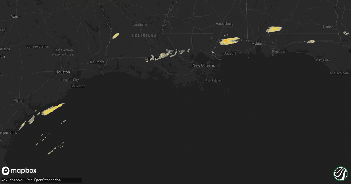
Hail Map on February 18, 2012
Get this storm
February 18 map
$229
one time, instant access
Download today. No call, no setup
Keep the $229
Bought the map and want the full workflow? Apply the entire $229 to a subscription within 7 days. None of it is wasted.
Every map, not just this one
This buys you this map. Subscription and you get every map we run, in the markets you choose from a few cities to whole states to nationwide. Plus real-time alerts the moment a storm fires.
Contact data
Name, contact info, occupancy, even credit band for addresses in the footprint. You go from where it hit to who to call.
Become the source they trust
Unlimited branding weather history reports on demand. You already have the documented answer ready for the property owner, and you are the one who showed up with it.
Property data and RoofTrace estimates
Pull up any address you have got, its value and the exact code rules for that jurisdiction, straight from One Click Code. Then RoofTrace estimates the squares, pitch, and roof value, priced the way you price.
Storm reports
Louisiana
| Date | Description |
|---|---|
| 02/18/201212:40 PM CST | Several trees blown down. |
| 02/18/201212:35 PM CST | Several trees blown down. |
| 02/18/201212:15 PM CST | Sherrifs office reported several trees blown down in north and northeast portion of parish from north of covington to near bush. |
| 02/18/201212:15 PM CST | Several trees blown down on cars vicinity of green street north of abita springs. |
| 02/18/201212:12 PM CST | Nws survey conducted in abita springs. Damage is mainly trees and some powerlines all in one direction. Damage is widespread and lacks a clear path. Survey results show |
| 02/18/201211:40 AM CST | Several trees blown down. Time based on radar. |
| 02/18/201211:35 AM CST | Several trees blown down. Time based on radar. |
| 02/18/201211:10 AM CST | Sheriffs office reported several trees down in southwest portion of parish in the vicinity of highway 16 and 1033. |
| 02/18/201210:40 AM CST | One tree was blown down in the st grarbiel area. |
| 02/18/201210:35 AM CST | Nickel to quarter sized hail observed by west baton rouge sheriffs in port allen. |
| 02/18/201210:20 AM CST | Tree blown down along with power line. |
| 02/18/201210:15 AM CST | Several large limbs snapped. Small metal storage sheds displaced. |
| 02/18/20129:45 AM CST | Public reported winds of 50 to 60 mph along ambassador caffrey boulevard |
| 02/18/20129:43 AM CST | A local report indicates 1.00 inch wind near BREAUX BRIDGE |
| 02/18/20129:30 AM CST | Public reported floor shaking and freight train sound |
| 02/18/20129:30 AM CST | Katc report of estimated 75 mph wind gust on the south side of lafayette with the bow echo. |
| 02/18/20129:10 AM CST | Power poles were blown down. |
| 02/18/20129:00 AM CST | Power lines and trees down from ih10 along la hwy 26 to about 3 miles south of ih10 |
| 02/18/20128:53 AM CST | A weak tornado touched down along highway 14 and 717 near klondike...ripped part of a metal roof off a barn...snapped a couple of telephone poles and trees. This tornad |
| 02/18/20128:04 AM CST | A local report indicates 63 MPH wind near 4 WNW GRAND LAKE |
| 02/18/20128:00 AM CST | A local report indicates 60 MPH wind near 10 E GRAND LAKE |
| 02/18/20127:50 AM CST | Power lines blown down. |
| 02/18/20127:45 AM CST | Tree reported across beglis parkway in sulphur. |
Georgia
| Date | Description |
|---|---|
| 02/17/201210:05 PM CST | The tri-county 911 center reported power outages across the southern portion of the county. |
| 02/17/201210:05 PM CST | The tri-county 911 center reported power outages across the southern portion of the county. |
| 02/17/201210:00 PM CST | The atkinson county department of roads and revenues reported that there was a possible tornado touchdown near cogdell highway on joe neugent road. There were 11 utilit |
| 02/17/20129:33 PM CST | Downed trees reported as cause of power outages. |
| 02/17/20129:30 PM CST | Trees down and power outages reported. |
| 02/17/20129:25 PM CST | Location is approximate...hail reported in western berrien county with core of severe thunderstorm. |
| 02/17/20129:18 PM CST | Golfball sized hail estimated between sparks and lenox. |
| 02/17/20128:58 PM CST | Trees down with hail also reported. Power outages. |
| 02/17/20128:55 PM CST | Several trees reported down across the county |
| 02/17/20128:45 PM CST | Multiple trees reported down. |
| 02/17/20128:45 PM CST | Tree limbs blown down. Time estimated from radar. |
| 02/17/20128:40 PM CST | Multiple trees and power lines down across the county. |
| 02/17/20128:35 PM CST | Downed trees blocked highway 133 at nelms road. Time estimated from radar. |
| 02/17/20128:32 PM CST | Trees and power lines down in pelham. Time estimated from radar. |
| 02/17/20128:30 PM CST | Multiple trees down |
| 02/17/20128:26 PM CST | County wide trees and power lines down. The majority of these reports are focused on the southern part of the county. |
| 02/17/20128:25 PM CST | Trees down and an area of power outage reported |
| 02/17/20128:25 PM CST | Trees down with power outages in parts of camilla. Time estimated from radar. |
| 02/17/20128:23 PM CST | Trees reported down near black jack rd and power lines down around bainbridge. |
| 02/17/20128:20 PM CST | Tree blown down on leary road near newton road. Time estimated from radar. |
| 02/17/20128:20 PM CST | Multiple trees and power lines down across county |
| 02/17/20128:20 PM CST | Trees blown down along yates spring road. |
| 02/17/20128:20 PM CST | Multiple trees and power lines down across the county |
| 02/17/20128:18 PM CST | A tree fell onto a house and a car on homestead avenue. Time estimated from radar. |
| 02/17/20128:10 PM CST | Several trees reported down across the county |
| 02/17/20128:10 PM CST | Tree damage with a tree falling on and damaging an outbuilding. Some power lines also brought down near a nearby house. About 12-15 miles out of bainbridge on highway 3 |
| 02/17/20128:05 PM CST | Mobile home near ga hwy 253 in extreme southern baker county...near the decatur county border...was blown over by thunderstorm winds. Some other light damage to nearby |
| 02/17/20128:01 PM CST | Multiple trees and power lines down across the county |
| 02/17/20128:01 PM CST | Several trees and power lines down. |
| 02/17/20127:15 PM CST | A few trees were reported down across early county. Time and location generalized based on strongest radar velocities. |
Mississippi
| Date | Description |
|---|---|
| 02/18/20121:50 PM CST | Trees down and barns damaged near necaise crossing |
| 02/18/20121:20 PM CST | Several trees and power lines blown down from thunderstorm winds. |
| 02/18/20121:10 PM CST | A local report indicates 1.75 inch wind near 1 W PERKINSTON |
| 02/18/20121:10 PM CST | Several trees blown over in high thunderstorm winds. |
| 02/18/201212:35 PM CST | Several trees and power lines down vicinity of highway 43 and pine grove road |
Florida
| Date | Description |
|---|---|
| 02/17/20128:20 PM CST | Multiple trees and power lines down across the county |
| 02/17/20127:40 PM CST | 2-3 trees down around the county...along with 1 power line. Time estimated |
| 02/17/20127:34 PM CST | One tree reported down |
| 02/17/20127:31 PM CST | Several trees down and reports of power outages north of bonifay |
| 02/17/20126:50 PM CST | Storm spotter estimates gust to 60 mph. |
Alabama
| Date | Description |
|---|---|
| 02/18/20125:40 PM CST | Damage to a barn...pump house and the back porch of a trailer |
| 02/18/20125:20 PM CST | Several trees down with some structural damage to a shed and a mobile home. Damage was reported in the cc road area on cactus court...just north of elberta. |
| 02/18/20123:48 PM CST | Several trees blown down due to severe thunderstorm winds. |
| 02/18/20123:24 PM CST | Trees blown down by thunderstorm winds across interstate 65 between mile markers 54 and 55. |
| 02/18/20123:24 PM CST | Trees and power lines blown down by severe thunderstorm winds. |
| 02/17/20127:30 PM CST | Quarter inch hail and winds estimated between 40-50 mph |
| 02/17/20127:05 PM CST | Quarter inch hail and winds estimated between 40-50 mph |
| 02/17/20126:28 PM CST | Large oak trees snapped in half |
| 02/17/20126:07 PM CST | A few trees and power lines down around ozark. |
| 02/17/20126:07 PM CST | Quarter size hail and winds estimated between 40-50 mph |
Cities Impacted by Hail Map on February 18, 2012
- San Saba, TX
- Voca, TX
- Saint Martinville, LA
- Grosse Tete, LA
- Adel, GA
- Atmore, AL
- Perdido, AL
- Flomaton, AL
- Brewton, AL
- Goldthwaite, TX
- Perkinston, MS
- Wiggins, MS
- Iron City, GA
- Brinson, GA
- Sparks, GA
- Moultrie, GA
- Maurice, LA
- Rayne, LA
- Kaplan, LA
- Coolidge, GA
- Meigs, GA
- Lucedale, MS
- Poplarville, MS
- McHenry, MS
- Picayune, MS
- Carriere, MS
- Duson, LA
- Ochlocknee, GA
- Richland Springs, TX
- Nashville, GA
- Abita Springs, LA
- Tifton, GA
- Lenox, GA
- Omega, GA
- Livingston, LA
- Springfield, LA
- Holden, LA
- Saucier, MS
- Vancleave, MS
- Berlin, GA
- Deridder, LA
- Merryville, LA
- Leesville, LA
- Norman Park, GA
- Ellenton, GA
- Pelham, GA
- Camilla, GA
- Whigham, GA
- Sale City, GA
- Fredonia, TX
- Mason, TX
- Brady, TX
- Funston, GA
- Lakeland, GA
- Hartsfield, GA
- Westville, FL
- Ponce De Leon, FL
- Defuniak Springs, FL
- Bainbridge, GA
- Doerun, GA
- Brooklyn, MS
- Lafayette, LA
- Carencro, LA
- Sunshine, LA
- Plaquemine, LA
- Pearl River, LA
- Valdosta, GA
- Broussard, LA
- Breaux Bridge, LA
- Denham Springs, LA
- Baton Rouge, LA
- Stockton, AL
- Little River, AL
- Pavo, GA
- Barney, GA
- Lumberton, MS
- Albany, LA
- Hammond, LA
- Addis, LA
- Port Allen, LA
- Prairieville, LA
- Greenville, FL