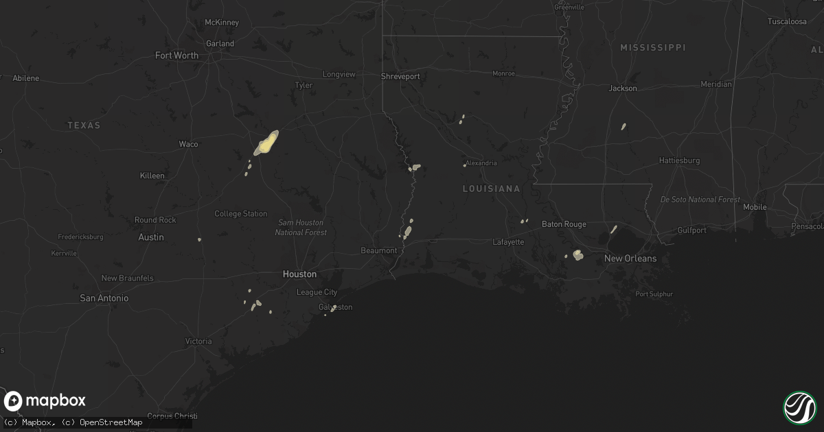
Hail Map in Texas on January 25, 2012
Get this storm
January 25 map
$229
one time, instant access
Download today. No call, no setup
Keep the $229
Bought the map and want the full workflow? Apply the entire $229 to a subscription within 7 days. None of it is wasted.
Every map, not just this one
This buys you this map. Subscription and you get every map we run, in the markets you choose from a few cities to whole states to nationwide. Plus real-time alerts the moment a storm fires.
Contact data
Name, contact info, occupancy, even credit band for addresses in the footprint. You go from where it hit to who to call.
Become the source they trust
Unlimited branding weather history reports on demand. You already have the documented answer ready for the property owner, and you are the one who showed up with it.
Property data and RoofTrace estimates
Pull up any address you have got, its value and the exact code rules for that jurisdiction, straight from One Click Code. Then RoofTrace estimates the squares, pitch, and roof value, priced the way you price.
Storm reports in Texas
Texas
| Date | Description |
|---|---|
| 01/25/20123:50 PM CST | Retired nws employee reported gusts 50 to 70 mph. |
| 01/25/20121:02 PM CST | Ham radio operator relayed a report via facebook of a tornado spotted near magnolia springs. |
| 01/25/20121:02 PM CST | A tornado touched down along fm 1005...blowning some trees down. It was on the ground for 0.8 miles and its width was 10 yards. |
| 01/25/20121:00 PM CST | A tornado touched down near the kirbyville airport where it tore part of a metal roof off a home...and went into western sections of kirbyville...blowing trees down and |
| 01/25/20121:00 PM CST | Kbmt relayed a public report of a tornado touchdown near kirbyville. Reported damage includes a trailer and multiple mailboxes. |
| 01/25/201212:58 PM CST | Trees down near yellowpine. |
| 01/25/201212:35 PM CST | Ham radio operator relayed a report via facebook of quarter size hail near jasper. |
| 01/25/201212:30 PM CST | A couple miles south of fred...several trees were blown down...a carport was damaged...and a shed lost some tin from its roof. The tornado path was 0.4 miles and its wi |
| 01/25/201212:30 PM CST | Ham radio operator relayed a report via facebook of a tornado on the ground near fred. |
| 01/25/201212:05 PM CST | Ef0 tornado near highway 35 and plum street. Chevron gas station had the gas pump awning destroyed and a business south of plum street had its roof peeled back. Damage |
| 01/25/201212:05 PM CST | Several trees were blown down or snapped along sections of post oak road...extending over highway 69. The path length was 3 miles and its width was 20 yards. |
| 01/25/201211:35 AM CST | Power lines down and pole down with low hanging lines on fm 360. |
| 01/25/201210:56 AM CST | An ef0 tornado touched down 11 miles northeast of mt enterprise tx along hwy 315 and moved east northeast crossing cr 164 and cr 163. Several trees were snapped and upr |
| 01/25/201210:40 AM CST | Trees down in angelina county. |
| 01/25/201210:40 AM CST | Report of roof blown off house and blocking parts of highway 259. |
| 01/25/201210:35 AM CST | Wooden guard shack at food plant blown over and moved about 50 feet. |
| 01/25/201210:32 AM CST | *** 1 inj *** an ef1 tornado touched down southwest of mt enterprise and moved through town. 1 large tree fell on a house and a carport was torn from another injuring 1 |
| 01/25/201210:20 AM CST | Several downed trees along highway 204. |
| 01/25/201210:00 AM CST | Tree down near fm road 1911. |
| 01/25/20129:10 AM CST | A ef0 tornado briefly touched down in a residential section of huntsville on roundabout rd. Causing siginificant tree damage. One of the trees did fall on nearby house |
| 01/25/20129:06 AM CST | Tornado touched down in home depot parking lot on i-45 then crossed freeway into dodge dealership and then lifted back into clouds near motel. Damage to a portable buil |
| 01/25/20129:05 AM CST | *** 1 inj *** widespread damage in and around huntsville from 900 to 915 time frame. Numerous trees down throughout the city. Light pole blown down on new truck. Roof d |
| 01/25/20129:00 AM CST | Two storage buildings blown down. Trees also blown down in the same location. Cr 181 and cr 179 |
| 01/25/20128:42 AM CST | Downed trees in montgomery county. |
| 01/25/20128:40 AM CST | Trees and power lines blown down near county road 444 and fm 315 |
| 01/25/20128:30 AM CST | Trees down across houston county. |
| 01/25/20128:30 AM CST | Widespread damage in and around huntsville from 830 to 930 time frane. |
| 01/25/20128:12 AM CST | 18 wheeler truck blown over on interstate 45 at the 145 mile marker. |
| 01/25/20128:05 AM CST | Home destroyed by possible downburst near the intersection of us287 and fm2706 |
| 01/25/20128:00 AM CST | County wide damage including roof damage and downed power lines. |
| 01/25/20128:00 AM CST | Trees snapped or uprooted along a narrow path. Barn destroyed with tin from roof fanned out in different directions and thrown in some cases about 200 yards. Minor roof |
| 01/25/20128:00 AM CST | Barn damage. Roof and structure damage to house on cr 116 in caldwell. |
| 01/25/20127:24 AM CST | Building wall veneer fell down at texas avenue and university. |
| 01/25/20127:20 AM CST | County wide damage including roof damage and downed power lines. |
| 01/25/20127:17 AM CST | Ef0 tornado touched down west of county road 50 just to the north of brenham municipal airport. The tornado traveled to near the intersection of fm262 and cr65. It dest |
| 01/25/20127:15 AM CST | 70 mph gust at brenham awos. |
| 01/25/20127:15 AM CST | Damage to garage door and and roof damage to house at intersection of hwy 30 and fm 158. |
| 01/25/20127:00 AM CST | Several trees blown down and some buildings destroyed. |
| 01/25/20127:00 AM CST | Tin constucted tire shop on hwy 36 destroyed. |
| 01/25/20126:45 AM CST | Trees down and roof damage at fm 975 at second creek. 1 home and 4 barns damaged in deanville at cr 116 and fm 111. Tree and roof damage at fm 111 and cr 121. Building |
| 01/25/20126:43 AM CST | Swath of damage extended from just northeast of deanville to just southeast of caldwell. Damage appeared tornadic along southern portion of that area with numerous tree |
| 01/25/20126:30 AM CST | Trees down along fm 975 in caldwell. |
All States Impacted by Hail Map on January 25, 2012
Cities Impacted by Hail Map on January 25, 2012
- Convent, LA
- Saint James, LA
- Wharton, TX
- East Bernard, TX
- Anacoco, LA
- Florien, LA
- Merryville, LA
- Ponchatoula, LA
- Galveston, TX
- Starks, LA
- Timpson, TX
- Garrison, TX
- Krotz Springs, LA
- Buffalo, TX
- Oakwood, TX
- Orange, TX
- Palestine, TX
- Napoleonville, LA
- Belle Rose, LA
- Jewett, TX
- Marquez, TX
- Pierre Part, LA
- Normangee, TX
- Wesson, MS
- Hazlehurst, MS
- Georgetown, MS
- Boyce, LA
- Eagle Lake, TX
- Damon, TX
- Giddings, TX
- Lottie, LA
- Atlanta, LA
- Winnfield, LA


