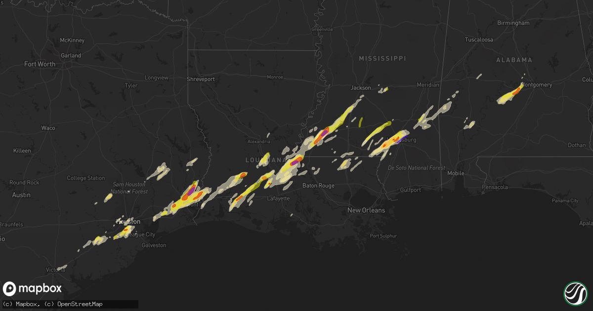
Hail Map in Louisiana on January 20, 2017
Get this storm
January 20 map
$229
one time, instant access
Download today. No call, no setup
Keep the $229
Bought the map and want the full workflow? Apply the entire $229 to a subscription within 7 days. None of it is wasted.
Every map, not just this one
This buys you this map. Subscription and you get every map we run, in the markets you choose from a few cities to whole states to nationwide. Plus real-time alerts the moment a storm fires.
Contact data
Name, contact info, occupancy, even credit band for addresses in the footprint. You go from where it hit to who to call.
Become the source they trust
Unlimited branding weather history reports on demand. You already have the documented answer ready for the property owner, and you are the one who showed up with it.
Property data and RoofTrace estimates
Pull up any address you have got, its value and the exact code rules for that jurisdiction, straight from One Click Code. Then RoofTrace estimates the squares, pitch, and roof value, priced the way you price.
Storm reports in Louisiana
Louisiana
| Date | Description |
|---|---|
| 01/19/201711:13 PM CST | A local report indicates 1.25 inch wind near WELSH |
| 01/19/201710:48 PM CST | Tree down across topsy bel rd.near texas eastern. |
| 01/19/201710:45 PM CST | A local report indicates 1.00 inch wind near OBERLIN |
All States Impacted by Hail Map on January 20, 2017
Cities Impacted by Hail Map on January 20, 2017
- Ville Platte, LA
- Eunice, LA
- Mamou, LA
- Church Point, LA
- Opelousas, LA
- Houston, TX
- Branch, LA
- Hayneville, AL
- Sardis, AL
- Pine Apple, AL
- Tyler, AL
- Lowndesboro, AL
- Minter, AL
- Camden, AL
- Rosharon, TX
- Fresno, TX
- Manvel, TX
- Pearland, TX
- Orange, TX
- Cameron, LA
- Vinton, LA
- Lettsworth, LA
- Gloster, MS
- McCall Creek, MS
- Brookhaven, MS
- Woodville, MS
- Meadville, MS
- Crosby, MS
- Roxie, MS
- Union Church, MS
- Hazlehurst, MS
- Natchez, MS
- Bude, MS
- Hattiesburg, MS
- Petal, MS
- Lumberton, MS
- Columbia, MS
- Foxworth, MS
- Sumrall, MS
- Sulphur, LA
- Vidor, TX
- Beaumont, TX
- Buna, TX
- Starks, LA
- Angola, LA
- Batchelor, LA
- Kokomo, MS
- Jayess, MS
- Oak Vale, MS
- Tylertown, MS
- Whatley, AL
- Grove Hill, AL
- Kinder, LA
- Mittie, LA
- Reeves, LA
- Oberlin, LA
- Krotz Springs, LA
- Port Barre, LA
- Fordoche, LA
- Arnaudville, LA
- Washington, LA
- Palmetto, LA
- Melville, LA
- Livingston, TX
- Iowa, LA
- Welsh, LA
- Warren, TX
- Woodville, TX
- Elton, LA
- New Roads, LA
- Morganza, LA
- Ventress, LA
- Livonia, LA
- Waynesboro, MS
- East Bernard, TX
- Needville, TX
- Rosenberg, TX
- Wharton, TX
- Boling, TX
- Beasley, TX
- Hockley, TX
- Montgomery, TX
- Plantersville, TX
- Magnolia, TX
- Waller, TX
- Sugar Land, TX
- Richmond, TX
- Kirbyville, TX
- Inez, TX
- Jackson, AL
- Ragley, LA
- Hankamer, TX
- Devers, TX
- Cheneyville, LA
- Saint Landry, LA
- Fluker, LA
- Roseland, LA
- Newbern, AL
- Faunsdale, AL
- Brandon, MS
- Pulaski, MS
- Pelahatchie, MS
- Morton, MS
- Wesson, MS
- Crystal Springs, MS
- Ellisville, MS
- Moselle, MS
- Purvis, MS
- Sandy Hook, MS
- Laurel, MS
- Shubuta, MS
- Wallisville, TX
- Anahuac, TX
- Liberty, TX
- Baytown, TX
- Poplarville, MS
- Jennings, LA
- Basile, LA
- Sour Lake, TX
- Nome, TX
- Call, TX
- Deweyville, TX
- Lumberton, TX
- Dequincy, LA
- China, TX
- Greensburg, LA
- Victoria, TX
- Edna, TX
- Gilbertown, AL
- Toxey, AL
- Buckatunna, MS
- Needham, AL
- Silas, AL
- Butler, AL
- Quitman, MS
- Goodrich, TX
- Friendswood, TX
- Florence, MS
- Bunkie, LA
- Lake Charles, LA
- Saint Francisville, LA
- Plaucheville, LA
- Monterey, LA
- Simmesport, LA
- Amite, LA
- Franklinton, LA
- Kentwood, LA
- Mount Hermon, LA
- Roanoke, LA
- Bell City, LA
- Lacassine, LA
- Deville, LA
- Pineville, LA
- Oakdale, LA
- Bassfield, MS
- Prentiss, MS
- Carson, MS
- Liberty, MS
- Smithdale, MS
- Hamshire, TX
- Winnie, TX
- Dry Creek, LA
- Ethel, LA
- Slaughter, LA
- Zachary, LA
- Moreauville, LA
- Marksville, LA
- Osyka, MS
- Magnolia, MS
- Collins, MS
- Prattville, AL
- Conroe, TX
- Jasper, TX
- Newton, TX
- Wiergate, TX
- Bellaire, TX
- Pennington, AL
- Chester, TX
- Morse, LA
- Gueydan, LA
- Lake Arthur, LA
- Missouri City, TX
- Breaux Bridge, LA
- Lottie, LA
- Glen Flora, TX
- El Campo, TX
- Ovett, MS
- Angie, LA
- Shepherd, TX
- Hempstead, TX
- Jackson, LA
- Evangeline, LA
- Louise, TX
- South Houston, TX
- Jeanerette, LA
- Terry, MS
- Iota, LA
- Seminary, MS
- Sontag, MS
- Monticello, MS


