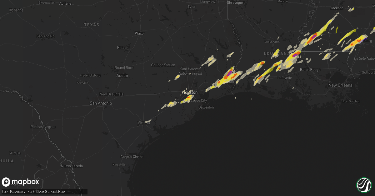
Hail Map on January 20, 2017
Get this storm
January 20 map
$229
one time, instant access
Download today. No call, no setup
Keep the $229
Bought the map and want the full workflow? Apply the entire $229 to a subscription within 7 days. None of it is wasted.
Every map, not just this one
This buys you this map. Subscription and you get every map we run, in the markets you choose from a few cities to whole states to nationwide. Plus real-time alerts the moment a storm fires.
Contact data
Name, contact info, occupancy, even credit band for addresses in the footprint. You go from where it hit to who to call.
Become the source they trust
Unlimited branding weather history reports on demand. You already have the documented answer ready for the property owner, and you are the one who showed up with it.
Property data and RoofTrace estimates
Pull up any address you have got, its value and the exact code rules for that jurisdiction, straight from One Click Code. Then RoofTrace estimates the squares, pitch, and roof value, priced the way you price.
States Impacted by Hail Map on January 20, 2017
Storm reports
California
| Date | Description |
|---|---|
| 01/20/20175:30 PM CST | Giant eucalyptus tree downed in pioneer park mission hills. |
| 01/20/20175:30 PM CST | Car submerged after driving into flooded roadway near highway 74 at menifee . |
| 01/20/20175:00 PM CST | 2 big eucalyptus trees blocking intersection of otay lakes and bonita road. . |
| 01/20/20175:00 PM CST | *** 1 inj *** large tree on car with driver trapped... Minor injury... At winter gardens and sapota in lakeside. |
| 01/20/20175:00 PM CST | Border field sdge weather station reported 64 mph wind gust. |
| 01/20/20174:56 PM CST | Asos station imperial beach |
| 01/20/20174:28 PM CST | Elfin forest mesonet reported 60 mph wind gust. . |
| 01/20/20174:23 PM CST | Utility pole down on residential fence. Telephone pole down with hanging wires near sr94 and steele canyon road. |
| 01/20/20174:22 PM CST | Mateo ridge raws in camp pendleton reported 70 mph gust. |
| 01/20/20174:16 PM CST | Lake matthews raws reported 67 mph gust. |
| 01/20/20174:03 PM CST | Large tree down blocking right lane of roadway near sr163 north and robinson avenue. |
| 01/20/20173:50 PM CST | Trained spotter reports numerous trees down between fountain valley and newport beach. . |
| 01/20/20173:24 PM CST | Palm tree blown down on brookhurst st. . |
| 01/20/20173:17 PM CST | Tree down on vehicle in the alleyway on browning avenue. |
| 01/20/20173:15 PM CST | Equipment damage caused by wind... 63 customers without power. |
| 01/20/20173:15 PM CST | Power poles and lines down. 63 customers without power. |
| 01/20/20173:13 PM CST | Roof damage... Broken window hit by debris... And broken rain gutters when thunderstorm passed over. |
| 01/20/20172:46 PM CST | Tree down blocking roadway 1405n off-ramp at bolsa avenue. |
| 01/20/20172:39 PM CST | Utility pole and tree down on roadway at riviera drive. . |
| 01/20/20172:29 PM CST | 2 inch diameter pine tree fell on roadway at gird road and sr76. |
| 01/19/20176:00 PM CST | Large tree blocking traffic on i-5 southbound near tocayo ave. |
Mississippi
| Date | Description |
|---|---|
| 01/20/20175:00 AM CST | Tree was down along meehan savoy road just west of us highway 11. Time estimated from radar. |
| 01/20/20174:55 AM CST | Large oak tree was was down along ms highway 513 near enterprise elementary school. Time estimated from radar. |
| 01/20/20174:49 AM CST | Tree was down on interstate 59 at mile marker 134. Time estimated from radar. |
| 01/20/20174:30 AM CST | Numerous trees down on highway 59 reported by spotter to broadcast media |
| 01/20/20174:25 AM CST | Trees down on hollis creek rd. Possible tornado. |
| 01/20/20174:09 AM CST | Trailer on cole dr. Off us hwy 29 blown off of foundation and was found upside down in woods nearby. Residents got out before damage occurred. Possible tornado. |
| 01/20/20174:06 AM CST | Structure damage on hinton loop at pumping station road. Possible tornado. |
| 01/20/20174:05 AM CST | *** 1 inj *** the tornado entered extreme nw perry county... Ms from ne forrest county 2 miles wnw of runnelstown... Ms and continued to move ne at 45 to 50 mph before |
| 01/20/20173:55 AM CST | Extensive damage across petal and ne forrest co from the tornado. Multiple structures damaged along with many trees and power lines. |
| 01/20/20173:55 AM CST | A local report indicates 1.75 inch wind near 7 NE PINEBUR |
| 01/20/20173:54 AM CST | Half dollar to ping pong sized hail near columbia reported via social media |
| 01/20/20173:51 AM CST | Trees down along glade dummy line rd |
| 01/20/20173:51 AM CST | A local report indicates 1.75 inch wind near 4 NNE PINEBUR |
| 01/20/20173:50 AM CST | Extensive damage all across south hattiesburg from i-59 across hwy 49 and into petal. Many structures heavyly damaged... A fire dept had a direct hit along with william |
| 01/20/20173:47 AM CST | Heavy damage to sturctures at and along carter and tatum camp rds. Numerous trees down. |
| 01/20/20173:45 AM CST | A few trees down near ross-mcphail rd |
| 01/20/20173:41 AM CST | Ping pong ball sized hail in the oak grove community reported via social media |
| 01/20/20173:38 AM CST | Trees down along old hwy 11. Some damage was also reported just west near purvis oloh and max white rd. |
| 01/20/20173:35 AM CST | *** 4 fatal... 56 inj *** tornado touched down at purvis-oloh road and gained strength before crossing the lamar/forrest county line and moving into hattiesburg. The to |
| 01/20/20173:35 AM CST | Golf ball hail reported by ema |
| 01/20/20173:15 AM CST | Three mobile homes had minor wind damage to awnings and roofs. One mobile home was moved off blocks by thunderstorm wind gust. Time estimated from radar. |
| 01/20/20173:14 AM CST | Multiple trees were down across covington county. Tree down across hwy 49 1.5 miles south of hwy 590 intersection. Trees were donw on cold springs... Kelly creek rd... |
| 01/20/20173:14 AM CST | Numerous trees down along hwy 49. |
| 01/20/20173:10 AM CST | Tree down across hwy 43 |
| 01/20/20172:46 AM CST | Quarter sized hail reported to ema by fire chief. |
| 01/20/20172:11 AM CST | Dime to quarter sized hail in florence reported by ema |
| 01/20/20171:20 AM CST | Pea to quarter sized hail reported in northwest lincoln county. Report via social media. |
| 01/20/201712:38 AM CST | Pea...dime and golf ball sized hail reported near the white apple community in southwesern franklin. Reported by ema |
Louisiana
| Date | Description |
|---|---|
| 01/19/201711:13 PM CST | A local report indicates 1.25 inch wind near WELSH |
| 01/19/201710:48 PM CST | Tree down across topsy bel rd.near texas eastern. |
| 01/19/201710:45 PM CST | A local report indicates 1.00 inch wind near OBERLIN |
Texas
| Date | Description |
|---|---|
| 01/19/20178:40 PM CST | A local report indicates 1.75 inch wind near ORANGE |
| 01/19/20178:14 PM CST | Sd reports dime to quarter size hail. |
| 01/19/20178:05 PM CST | Associated with wall cloud. |
| 01/19/20177:55 PM CST | A local report indicates 1.00 inch wind near LAKEVIEW |
| 01/19/20177:53 PM CST | A local report indicates 1.00 inch wind near VIDOR |
| 01/19/20176:10 PM CST | Public reports golf ball sized hail near hwy 288 at beltway 8 via twitter |
| 01/19/20176:05 PM CST | Public reports quarter sized hail off scott st near airport blvd via twitter |
Alabama
| Date | Description |
|---|---|
| 01/20/20175:55 AM CST | Ef1 tornado with 90 mph winds downed trees and damaged outbuildings near us highway 43. |
| 01/20/20175:53 AM CST | Damage reported to a home just south of octagon in marengo county. Trees down. Bricks from exterior in shower. Possible tornado. Via social media. |
| 01/20/20175:53 AM CST | Damage reported to a home just south of octagon in marengo county at the intersection of hummingbird ln and pillie rd. Trees down. Bricks from exterior in shower. Possi |
| 01/20/20175:38 AM CST | Tree down on highway 69. Another tree down on bashi road. |
| 01/20/20175:37 AM CST | Trees reported down near putnam baptist church. Possible tornado. |
| 01/20/20175:31 AM CST | A tornado continued from choctaw county into southeastern marengo county. The tornado crossed the river and ended near putnam. The damage was consistent with ef1 wind d |
| 01/20/20175:29 AM CST | A tornado continued from choctaw county into southeastern marengo county. The tornado crossed the river and ended near putnam. The damage was consistent with ef1 wind d |
| 01/20/20175:14 AM CST | *** 4 inj *** likely tornado produced major tree and power line damage across chapel hill road and pleasant hill road areas. Damage to 20-25 residences some with major |
| 01/20/20175:14 AM CST | Reports of trees and power lines down on parts of chapel hill road and pleasant hill road. Also some structural damage reported but extent of the damage not known at th |
| 01/20/20175:14 AM CST | *** 4 inj *** the tornado first touched down on clark road and continued 15 miles to the northeast to the choctaw and marengo county line. 4 homes were destroyed... Inc |
Cities Impacted by Hail Map on January 20, 2017
- Ville Platte, LA
- Eunice, LA
- Mamou, LA
- Church Point, LA
- Opelousas, LA
- Houston, TX
- Branch, LA
- Hayneville, AL
- Sardis, AL
- Pine Apple, AL
- Tyler, AL
- Lowndesboro, AL
- Minter, AL
- Camden, AL
- Rosharon, TX
- Fresno, TX
- Manvel, TX
- Pearland, TX
- Orange, TX
- Cameron, LA
- Vinton, LA
- Lettsworth, LA
- Gloster, MS
- McCall Creek, MS
- Brookhaven, MS
- Woodville, MS
- Meadville, MS
- Crosby, MS
- Roxie, MS
- Union Church, MS
- Hazlehurst, MS
- Natchez, MS
- Bude, MS
- Hattiesburg, MS
- Petal, MS
- Lumberton, MS
- Columbia, MS
- Foxworth, MS
- Sumrall, MS
- Sulphur, LA
- Vidor, TX
- Beaumont, TX
- Buna, TX
- Starks, LA
- Angola, LA
- Batchelor, LA
- Kokomo, MS
- Jayess, MS
- Oak Vale, MS
- Tylertown, MS
- Whatley, AL
- Grove Hill, AL
- Kinder, LA
- Mittie, LA
- Reeves, LA
- Oberlin, LA
- Krotz Springs, LA
- Port Barre, LA
- Fordoche, LA
- Arnaudville, LA
- Washington, LA
- Palmetto, LA
- Melville, LA
- Livingston, TX
- Iowa, LA
- Welsh, LA
- Warren, TX
- Woodville, TX
- Elton, LA
- New Roads, LA
- Morganza, LA
- Ventress, LA
- Livonia, LA
- Waynesboro, MS
- East Bernard, TX
- Needville, TX
- Rosenberg, TX
- Wharton, TX
- Boling, TX
- Beasley, TX
- Hockley, TX
- Montgomery, TX
- Plantersville, TX
- Magnolia, TX
- Waller, TX
- Sugar Land, TX
- Richmond, TX
- Kirbyville, TX
- Inez, TX
- Jackson, AL
- Ragley, LA
- Hankamer, TX
- Devers, TX
- Cheneyville, LA
- Saint Landry, LA
- Fluker, LA
- Roseland, LA
- Newbern, AL
- Faunsdale, AL
- Brandon, MS
- Pulaski, MS
- Pelahatchie, MS
- Morton, MS
- Wesson, MS
- Crystal Springs, MS
- Ellisville, MS
- Moselle, MS
- Purvis, MS
- Sandy Hook, MS
- Laurel, MS
- Shubuta, MS
- Wallisville, TX
- Anahuac, TX
- Liberty, TX
- Baytown, TX
- Poplarville, MS
- Jennings, LA
- Basile, LA
- Sour Lake, TX
- Nome, TX
- Call, TX
- Deweyville, TX
- Lumberton, TX
- Dequincy, LA
- China, TX
- Greensburg, LA
- Victoria, TX
- Edna, TX
- Gilbertown, AL
- Toxey, AL
- Buckatunna, MS
- Needham, AL
- Silas, AL
- Butler, AL
- Quitman, MS
- Goodrich, TX
- Friendswood, TX
- Florence, MS
- Bunkie, LA
- Lake Charles, LA
- Saint Francisville, LA
- Plaucheville, LA
- Monterey, LA
- Simmesport, LA
- Amite, LA
- Franklinton, LA
- Kentwood, LA
- Mount Hermon, LA
- Roanoke, LA
- Bell City, LA
- Lacassine, LA
- Deville, LA
- Pineville, LA
- Oakdale, LA
- Bassfield, MS
- Prentiss, MS
- Carson, MS
- Liberty, MS
- Smithdale, MS
- Hamshire, TX
- Winnie, TX
- Dry Creek, LA
- Ethel, LA
- Slaughter, LA
- Zachary, LA
- Moreauville, LA
- Marksville, LA
- Osyka, MS
- Magnolia, MS
- Collins, MS
- Prattville, AL
- Conroe, TX
- Jasper, TX
- Newton, TX
- Wiergate, TX
- Bellaire, TX
- Pennington, AL
- Chester, TX
- Morse, LA
- Gueydan, LA
- Lake Arthur, LA
- Missouri City, TX
- Breaux Bridge, LA
- Lottie, LA
- Glen Flora, TX
- El Campo, TX
- Ovett, MS
- Angie, LA
- Shepherd, TX
- Hempstead, TX
- Jackson, LA
- Evangeline, LA
- Louise, TX
- South Houston, TX
- Jeanerette, LA
- Terry, MS
- Iota, LA
- Seminary, MS
- Sontag, MS
- Monticello, MS