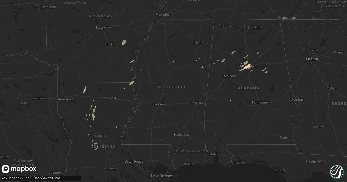
Hail Map in Mississippi on December 25, 2015
Get this storm
December 25 map
$229
one time, instant access
Download today. No call, no setup
Keep the $229
Bought the map and want the full workflow? Apply the entire $229 to a subscription within 7 days. None of it is wasted.
Every map, not just this one
This buys you this map. Subscription and you get every map we run, in the markets you choose from a few cities to whole states to nationwide. Plus real-time alerts the moment a storm fires.
Contact data
Name, contact info, occupancy, even credit band for addresses in the footprint. You go from where it hit to who to call.
Become the source they trust
Unlimited branding weather history reports on demand. You already have the documented answer ready for the property owner, and you are the one who showed up with it.
Property data and RoofTrace estimates
Pull up any address you have got, its value and the exact code rules for that jurisdiction, straight from One Click Code. Then RoofTrace estimates the squares, pitch, and roof value, priced the way you price.
Storm reports in Mississippi
Mississippi
| Date | Description |
|---|---|
| 12/25/20154:47 PM CST | Tree down |
| 12/25/20153:51 PM CST | Chicken house damaged with tin roof partially off along with trees down. Occurred along co road 529. Max winds 80 mph. Maximum width 50 yards. Path length 0.7 miles. |
| 12/25/20153:44 PM CST | A couple trees were down. |
| 12/25/20152:34 PM CST | Downed power lines on the north side of columbus |
| 12/25/20159:17 AM CST | Trees down on huddleston street. |
| 12/25/20159:02 AM CST | Tree down across highway 51 near devalda drive. Reported by emergency management |
All States Impacted by Hail Map on December 25, 2015
Cities Impacted by Hail Map on December 25, 2015
- Fairfield, AL
- Birmingham, AL
- Lake Providence, LA
- Oak Grove, LA
- Columbus, MS
- Cumberland Furnace, TN
- Vanleer, TN
- Homer, LA
- Athens, LA
- Dodson, LA
- Colfax, LA
- Montgomery, LA
- West Point, MS
- Fayette, AL
- Lena, LA
- Oneonta, AL
- Osage Beach, MO
- Lake Ozark, MO
- Kaiser, MO
- Mount Olive, AL
- Docena, AL
- Brookside, AL
- Adamsville, AL
- Graysville, AL
- Fultondale, AL
- Gardendale, AL
- Talladega, AL
- Piggott, AR
- Campbell, MO
- Saint Francis, AR
- Bolivar, MO
- Alpine, AL
- Eudora, AR
- Winnfield, LA
- Stuttgart, AR
- Jonesboro, LA
- Forest Hill, LA
- Glenmora, LA
- Atlanta, LA
- Oak Ridge, LA
- Rayville, LA
- Walnut Grove, MO
- Aldrich, MO
- Okolona, MS
- Bankston, AL
- Mulga, AL
- Everton, MO
- Dolomite, AL
- Bessemer, AL
- Millport, AL
- Fair Play, MO
- Ruston, LA
- Oran, MO
- Essex, MO
- Pleasant Grove, AL
- Miller, MO
- Duck Hill, MS
- Oakdale, LA
- Sunrise Beach, MO
- Rohwer, AR
- Benoit, MS
- Sarcoxie, MO
- Goldonna, LA
- Hayden, AL
- Warrior, AL
- Jonesville, LA
- Bell City, MO
- Sikeston, MO
- De Witt, AR
- Almyra, AR
- Oxly, MO
- Doniphan, MO
- Cunningham, TN
- Nauvoo, AL
- Carbon Hill, AL
- Jasper, AL
- Elmer, LA
- Hineston, LA
- Empire, AL
- Kennedy, AL
- Natchitoches, LA
- Dubach, LA
- Uniontown, AL
- Ville Platte, LA
- La Russell, MO
- Aberdeen, MS
- Prairie, MS
- Adger, AL


