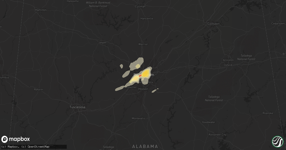
Hail Map in Birmingham, AL on December 25, 2015
Get this storm
December 25 map
$229
one time, instant access
Download today. No call, no setup
Keep the $229
Bought the map and want the full workflow? Apply the entire $229 to a subscription within 7 days. None of it is wasted.
Every map, not just this one
This buys you this map. Subscription and you get every map we run, in the markets you choose from a few cities to whole states to nationwide. Plus real-time alerts the moment a storm fires.
Contact data
Name, contact info, occupancy, even credit band for addresses in the footprint. You go from where it hit to who to call.
Become the source they trust
Unlimited branding weather history reports on demand. You already have the documented answer ready for the property owner, and you are the one who showed up with it.
Property data and RoofTrace estimates
Pull up any address you have got, its value and the exact code rules for that jurisdiction, straight from One Click Code. Then RoofTrace estimates the squares, pitch, and roof value, priced the way you price.
Storm reports in Birmingham, AL
Birmingham, AL
| Date | Description |
|---|---|
| 12/25/20155:05 PM CST | A rapid decline in damage intensity was observed as the tornado moved northeast... With ef-1 and ef-0 damage consisting of roof damage... As well as snapped and uprooted tr ( |
| 12/25/20155:01 PM CST | Debris in the air and a tds dual pol signature |
| 12/25/20154:59 PM CST | A rapid decline in damage intensity was observed as the tornado moved northeast... With ef-1 and ef-0 damage consisting of roof damage... As well as snapped and uprooted tr ( |
| 12/25/20154:56 PM CST | Trees down and structural damage along jefferson ave sw and grasselli blvd sw. Person trapped in their homes. Unknown injuries. Time estimated from radar. Updated for l |
| 12/25/20154:55 PM CST | *** 2 inj *** tornado initially touched down 1.7 miles ssw of midfield. Initial damage was found near downey street and 51st street... Where trees were toppled and snappe (bm |
| 12/24/20159:40 PM CST | Structural damage near intersection of jefferson avenue sw and 50th street southwest. Possible tornado. |
All States Impacted by Hail Map on December 25, 2015
All Cities Impacted by Hail Map on December 25, 2015
- Fairfield, AL
- Birmingham, AL
- Lake Providence, LA
- Oak Grove, LA
- Columbus, MS
- Cumberland Furnace, TN
- Vanleer, TN
- Homer, LA
- Athens, LA
- Dodson, LA
- Colfax, LA
- Montgomery, LA
- West Point, MS
- Fayette, AL
- Lena, LA
- Oneonta, AL
- Osage Beach, MO
- Lake Ozark, MO
- Kaiser, MO
- Mount Olive, AL
- Docena, AL
- Brookside, AL
- Adamsville, AL
- Graysville, AL
- Fultondale, AL
- Gardendale, AL
- Talladega, AL
- Piggott, AR
- Campbell, MO
- Saint Francis, AR
- Bolivar, MO
- Alpine, AL
- Eudora, AR
- Winnfield, LA
- Stuttgart, AR
- Jonesboro, LA
- Forest Hill, LA
- Glenmora, LA
- Atlanta, LA
- Oak Ridge, LA
- Rayville, LA
- Walnut Grove, MO
- Aldrich, MO
- Okolona, MS
- Bankston, AL
- Mulga, AL
- Everton, MO
- Dolomite, AL
- Bessemer, AL
- Millport, AL
- Fair Play, MO
- Ruston, LA
- Oran, MO
- Essex, MO
- Pleasant Grove, AL
- Miller, MO
- Duck Hill, MS
- Oakdale, LA
- Sunrise Beach, MO
- Rohwer, AR
- Benoit, MS
- Sarcoxie, MO
- Goldonna, LA
- Hayden, AL
- Warrior, AL
- Jonesville, LA
- Bell City, MO
- Sikeston, MO
- De Witt, AR
- Almyra, AR
- Oxly, MO
- Doniphan, MO
- Cunningham, TN
- Nauvoo, AL
- Carbon Hill, AL
- Jasper, AL
- Elmer, LA
- Hineston, LA
- Empire, AL
- Kennedy, AL
- Natchitoches, LA
- Dubach, LA
- Uniontown, AL
- Ville Platte, LA
- La Russell, MO
- Aberdeen, MS
- Prairie, MS
- Adger, AL


