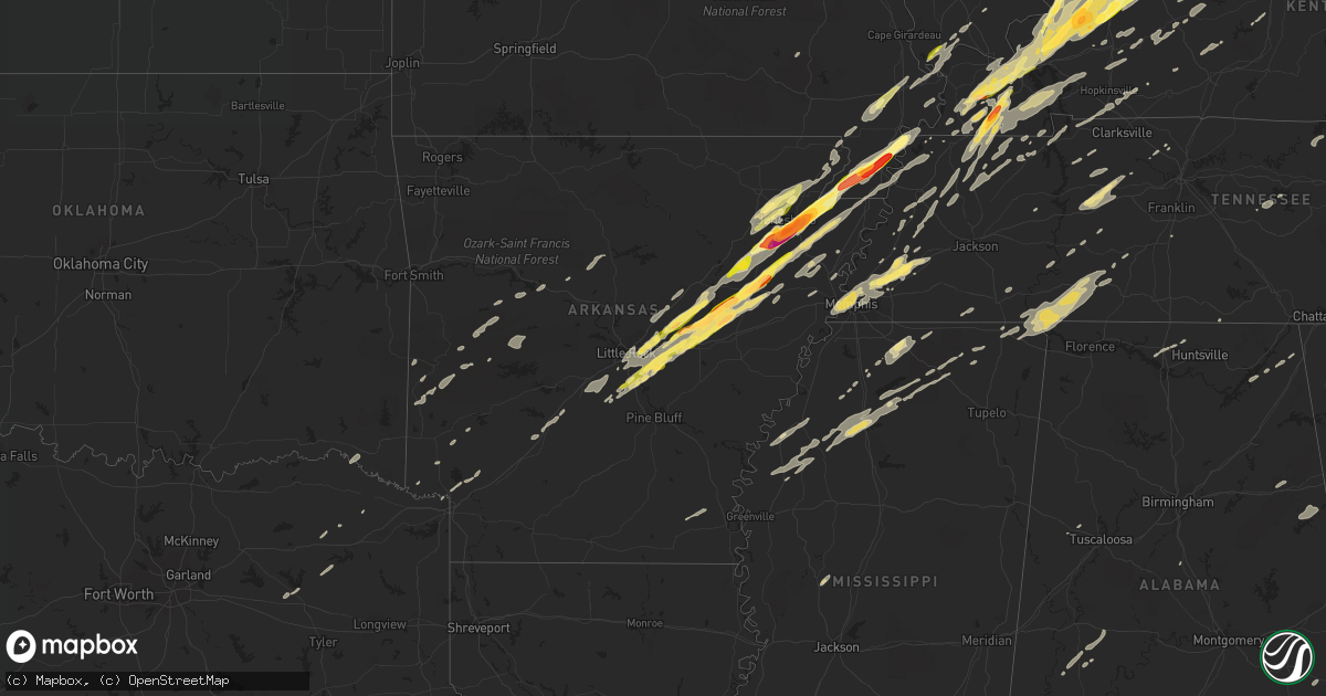
Hail Map in Arkansas on December 23, 2015
Get this storm
December 23 map
$229
one time, instant access
Download today. No call, no setup
Keep the $229
Bought the map and want the full workflow? Apply the entire $229 to a subscription within 7 days. None of it is wasted.
Every map, not just this one
This buys you this map. Subscription and you get every map we run, in the markets you choose from a few cities to whole states to nationwide. Plus real-time alerts the moment a storm fires.
Contact data
Name, contact info, occupancy, even credit band for addresses in the footprint. You go from where it hit to who to call.
Become the source they trust
Unlimited branding weather history reports on demand. You already have the documented answer ready for the property owner, and you are the one who showed up with it.
Property data and RoofTrace estimates
Pull up any address you have got, its value and the exact code rules for that jurisdiction, straight from One Click Code. Then RoofTrace estimates the squares, pitch, and roof value, priced the way you price.
Storm reports in Arkansas
Arkansas
| Date | Description |
|---|---|
| 12/23/20152:55 PM CST | County em reports tornado damage south of marianna. Grain bins flattened... Roof blown off a brick house... Mobile home completely destroyed... Cabins damaged |
| 12/23/20152:43 PM CST | A local report indicates 1.75 inch wind near LAKE CITY |
| 12/23/20152:05 PM CST | A local report indicates 2.00 inch wind near COTTON PLANT |
| 12/23/20152:02 PM CST | A local report indicates 1.75 inch wind near FAIR OAKS |
| 12/23/20151:58 PM CST | A local report indicates 65 MPH wind near 3 W MANILA |
| 12/23/20151:37 PM CST | A local report indicates 1.25 inch wind near 1 S CARLISLE |
| 12/23/20151:27 PM CST | A local report indicates 2.75 inch wind near VALLEY VIEW |
| 12/23/20151:27 PM CST | A local report indicates 2.50 inch wind near BAY |
| 12/23/20151:21 PM CST | A local report indicates 1.75 inch wind near NEEDHAM |
| 12/23/20151:20 PM CST | A local report indicates 1.50 inch wind near 2 N ENGLAND |
| 12/23/20151:15 PM CST | A local report indicates 2.50 inch wind near 7 S JONESBORO |
| 12/23/20151:15 PM CST | Power lines down |
| 12/23/20151:13 PM CST | Local law enforement reports quarter sized hail south of jonesboro |
| 12/23/20151:10 PM CST | Report of golf ball sized hail in des arc. |
| 12/23/20151:00 PM CST | Quarter sized hail reported 11 miles sw of paragould |
| 12/23/201511:43 AM CST | Report of a tree down on evening street in judsonia |
| 12/23/201511:40 AM CST | Reports of power lines down along highway 236 around clay hill. |
| 12/23/20159:50 AM CST | Tree down in maynard. |
| 12/23/20159:30 AM CST | Trees down in ravenden. |
| 12/23/20159:30 AM CST | Tree down on muddy lane. |
| 12/23/20159:07 AM CST | Law enforcement reported several homes destroyed and a lot of structural damage in the highland area. |
| 12/23/20158:50 AM CST | Law enforecment reports power lines and power line poles down. |
| 12/23/20158:41 AM CST | Emergency management reports wind damage to a mobile home. |
| 12/23/20158:40 AM CST | Two homes were reported with trees on them as well as a barn blow down and roof damage to others. Highway 87 was blocked with trees north of mountain view. |
| 12/23/20158:40 AM CST | Law enforcement reports that a roof was displaced from a barn. |
| 12/23/20158:30 AM CST | Numerous trees and powerlines down in town. Trees blocking roadways. |
| 12/23/20158:26 AM CST | A tree was reported on a house in fairfield bay. |
| 12/23/20158:20 AM CST | Damage to a house was reported in bee branch by law enforcement. |
| 12/23/20158:20 AM CST | Large tree was reported blocking highway 5 south. |
| 12/23/20158:20 AM CST | Damage to a house was reported in bee branch. |
| 12/23/20158:18 AM CST | Observer reported both powerlines and large pine trees down. |
| 12/23/20158:01 AM CST | Trees uprooted and damage to awning in yard. |
| 12/23/20157:55 AM CST | Local coordinator reported fallen tree on house in atkins. There were also reoprts of trees and power lines down in the southeast part of pope county. |
| 12/23/20157:40 AM CST | *** 1 fatal *** local coordinator reported fallen tree on house in atkins. There were also reports of trees and power lines down in the southeast part of pope county. |
| 12/23/20157:30 AM CST | Multiple reports of trees and power lines down around the county. |
| 12/23/20157:16 AM CST | Multiple reports of trees and power lines down around the county. |
All States Impacted by Hail Map on December 23, 2015
Cities Impacted by Hail Map on December 23, 2015
- Jonesboro, AR
- Bay, AR
- Harrisburg, AR
- Weiner, AR
- Memphis, TN
- Dickson, TN
- Ledbetter, KY
- Grand Bay, AL
- Daphne, AL
- Mobile, AL
- Theodore, AL
- Mason, TN
- Stanton, TN
- Owensboro, KY
- Brighton, TN
- Cordova, TN
- Proctor, AR
- Marion, AR
- Arlington, TN
- Atoka, TN
- West Memphis, AR
- Covington, TN
- Millington, TN
- Clay, KY
- Ariton, AL
- Brundidge, AL
- Jack, AL
- Lutts, TN
- Hohenwald, TN
- Michie, TN
- Glen, MS
- Burnsville, MS
- Waynesboro, TN
- Iron City, TN
- Iuka, MS
- Counce, TN
- Savannah, TN
- Cypress Inn, TN
- Collinwood, TN
- Lawrenceburg, TN
- Waterloo, AL
- Utica, KY
- Kuttawa, KY
- Cloverport, KY
- Manitou, KY
- Brookport, IL
- Smithland, KY
- Eddyville, KY
- Tiline, KY
- Rhodelia, KY
- Tell City, IN
- Hawesville, KY
- Payneville, KY
- Burna, KY
- Salem, KY
- Arlington, KY
- Philpot, KY
- Uniontown, KY
- Slaughters, KY
- Boaz, KY
- Whitesville, KY
- Derby, IN
- Central, IN
- Henderson, KY
- Corydon, KY
- Madisonville, KY
- Corydon, IN
- Morganfield, KY
- Rome, IN
- Hickory, KY
- Dixon, KY
- Sturgis, KY
- Elizabeth, IN
- Sebree, KY
- Melber, KY
- Nebo, KY
- Paducah, KY
- Battletown, KY
- Providence, KY
- Hardinsburg, KY
- Grand Rivers, KY
- Hanson, KY
- Waverly, KY
- Dawson Springs, KY
- Robards, KY
- Rumsey, KY
- Symsonia, KY
- Cunningham, KY
- Gilbertsville, KY
- Calhoun, KY
- Fancy Farm, KY
- Lanesville, IN
- Mayfield, KY
- Stephensport, KY
- Benton, KY
- Princeton, KY
- Bardwell, KY
- Clinton, KY
- Calvert City, KY
- Mauckport, IN
- Cannelton, IN
- Lewisport, KY
- Maceo, KY
- Fredonia, KY
- Marion, KY
- Union Star, KY
- Magnolia, AL
- Cumberland City, TN
- Erin, TN
- Saint Francis, AR
- Campbell, MO
- Piggott, AR
- Mena, AR
- Harvest, AL
- Paris, MO
- Cherry Valley, AR
- Little Rock, AR
- Redfield, AR
- Lonoke, AR
- Sheridan, AR
- Hickory Ridge, AR
- Carlisle, AR
- Biscoe, AR
- Keo, AR
- Scott, AR
- England, AR
- Des Arc, AR
- Hensley, AR
- Hazen, AR
- McCrory, AR
- Augusta, AR
- Griffithville, AR
- Colt, AR
- Cotton Plant, AR
- Wynne, AR
- Hickman, KY
- Mounds, IL
- Dresden, TN
- Palmersville, TN
- Cottage Grove, TN
- Paris, TN
- Puryear, TN
- Water Valley, KY
- Wingo, KY
- Sedalia, KY
- Martin, TN
- Kirksey, KY
- Fulton, KY
- South Fulton, TN
- Dukedom, TN
- Beebe, AR
- Ward, AR
- Austin, AR
- Cabot, AR
- McRae, AR
- Thomaston, AL
- Uniontown, AL
- Faunsdale, AL
- Linden, AL
- Bradford, TN
- Gleason, TN
- Greenfield, TN
- Henry, TN
- McKenzie, TN
- Friendship, TN
- Dyersburg, TN
- Newbern, TN
- English, IN
- Branchville, IN
- Leopold, IN
- Wickes, AR
- Vandervoort, AR
- Cove, AR
- Bono, AR
- Walnut Ridge, AR
- Benton, MS
- Yazoo City, MS
- Ashdown, AR
- Ogden, AR
- Farmington, KY
- Roundhill, KY
- Jetson, KY
- Bowling Green, KY
- Brownsville, KY
- Echola, AL
- Elrod, AL
- Myrtle, MS
- Ripley, MS
- Blue Mountain, MS
- Hickory Flat, MS
- Ripley, TN
- Brownsville, TN
- Pope, MS
- Oakland, MS
- Enid, MS
- Barlow, KY
- Enterprise, AL
- Elba, AL
- New Brockton, AL
- Plainview, AR
- Hurricane Mills, TN
- McEwen, TN
- Senatobia, MS
- Como, MS
- East Prairie, MO
- Clarksdale, MS
- Duncan, MS
- Alligator, MS
- Searcy, AR
- Judsonia, AR
- Liberty, IL
- Payson, IL
- Holly Springs, MS
- Byhalia, MS
- Boonville, IN
- Tennyson, IN
- Russellville, AR
- Elkton, KY
- Hopkinsville, KY
- Trenton, KY
- Pembroke, KY
- Tiptonville, TN
- Lake City, AR
- Portageville, MO
- Steele, MO
- Kennett, MO
- Senath, MO
- Hayti, MO
- Black Oak, AR
- Fisher, AR
- Bragg City, MO
- Leachville, AR
- Arbyrd, MO
- Monette, AR
- Wardell, MO
- Gobler, MO
- Hornersville, MO
- Cardwell, MO
- Crofton, KY
- White Plains, KY
- Graham, KY
- Bremen, KY
- Charlestown, IN
- Dell, AR
- Trumann, AR
- Caraway, AR
- Manila, AR
- Marked Tree, AR
- Quincy, IL
- Palmyra, MO
- Fowler, IL
- Murray, KY
- Hardin, KY
- Cadiz, KY
- Rutherford, TN
- Kenton, TN
- Almo, KY
- Cerulean, KY
- Hazel, KY
- Dexter, KY
- Sharon, TN
- Big Rock, TN
- Oak Grove, KY
- Herndon, KY
- Courtland, MS
- Charleston, MS
- Coldwater, MS
- Summertown, TN
- Vienna, IL
- Belknap, IL
- Falls Of Rough, KY
- Texarkana, TX
- Wedowee, AL
- Woodland, AL
- Parma, MO
- Essex, MO
- Mount Vernon, TX
- Mendon, IL
- Henagar, AL
- Pisgah, AL
- Drew, MS
- Cleveland, MS
- Tutwiler, MS
- Ruleville, MS
- Merigold, MS
- Sims, AR
- Monroe, TN
- Byrdstown, TN
- Mount Vernon, IN
- Buchanan, GA
- Tallapoosa, GA
- Greenbrier, TN
- Springfield, TN
- Paragould, AR
- Donaldson, AR
- Vanleer, TN
- Marmaduke, AR
- Rector, AR
- Taylor, MS
- Oxford, MS
- Sardis, MS
- Alba, TX
- Quitman, TX
- Frankfort, KY
- Dardanelle, AR
- Delaware, AR
- De Mossville, KY
- Crittenden, KY
- Morning View, KY
- Parks, AR
- Dubois, IN
- Jasper, IN
- Livingston, TN
- Allons, TN
- Hilham, TN
- Annona, TX
- Cleveland, AR
- Clinton, AR
- Center Ridge, AR
- Scotland, AR
- Greenway, AR
- Michigan City, MS
- Lamar, MS
- Halls, TN
- Patterson, MO
- Athens, AL
- Tanner, AL
- Henning, TN
- Seale, AL
- Central City, KY
- Beaver Dam, KY
- Drakesboro, KY
- Rockport, KY
- Lambert, MS
- Batesville, MS
- Water Valley, MS
- Grand Chain, IL
- Karnak, IL
- Ullin, IL
- Jacksonville, AR
- North Little Rock, AR
- Caneyville, KY
- Olaton, KY
- Horse Branch, KY
- Dyer, TN
- Trenton, TN
- Lewisburg, KY
- Tyronza, AR
- New Albany, IN
- Newport, AR
- Tennessee Ridge, TN
- Stewart, TN
- Lockesburg, AR
- Fordsville, KY
- Hartford, KY
- Greenville, KY
- Powderly, KY
- Oden, AR
- Mendenhall, MS
- Ursa, IL
- Ashland City, TN
- Hamburg, AR
- Potts Camp, MS
- Coatsburg, IL
- Taylor, MO
- Camp Point, IL
- Charlotte, TN
- Earle, AR
- Cash, AR
- Irvington, AL
- Crawfordsville, AR
- Beech Grove, AR
- Swifton, AR
- Alicia, AR
- Evansville, IN
- Harned, KY
- Irvington, KY
- Webster, KY
- Dover, TN
- Buchanan, TN
- Union City, TN
- Graham, AL
- Heflin, AL
- Lineville, AL
- Cromwell, KY
- Smithville, TN
- Beedeville, AR
- Scroggins, TX
- Winnsboro, TX
- Anniston, AL
- Guston, KY
- Brandenburg, KY
- Ekron, KY
- Rienzi, MS
- Nashville, AR
- Clarksville, TX
- Garvin, OK
- Idabel, OK
- Monroe City, MO
- Catron, MO
- Dexter, MO
- Matthews, MO
- Bertrand, MO
- Sikeston, MO
- Bernie, MO
- Lawrenceburg, KY
- Mount Eden, KY
- Watson, OK
- Bath Springs, TN
- Decaturville, TN
- Amagon, AR
- Traskwood, AR
- Benton, AR
- Bauxite, AR
- Liberty, TN
- Cairo, IL
- Pulaski, IL
- Mound City, IL
- Villa Ridge, IL
- Charleston, MO
- Olmsted, IL
- Kevil, KY
- Dyess, AR
- Dowelltown, TN
- Fairhope, AL
- Stapleton, AL
- Moss Point, MS
- Loxley, AL
- Somerville, TN
- Sharon Grove, KY
- Atkins, AR
- Hattieville, AR
- Middleton, TN
- Sulphur, IN
- Centerville, TN
- Dutton, AL
- Section, AL
- Pinola, MS
- Newhebron, MS
- Crenshaw, MS
- Langston, AL
- Talco, TX
- Boyle, MS
- Jemison, AL
- Elora, TN
- Hampshire, TN
- Mount Pleasant, TN
- Keokuk, IA
- Spring Hill, TN
- Corinth, MS
- Fulton, AR
- Only, TN
- Shelby, MS
- Lyon, MS
- Bald Knob, AR
- Dermott, AR
- Earlington, KY
- Munfordville, KY
- Upton, KY
- Brookland, AR
- Ider, AL
- Waddy, KY
- Arkadelphia, AR
- Westport, TN
- Pleasant View, TN
- Joelton, TN
- Washington, AR
- Malden, MO
- Bethel Springs, TN
- Adamsville, TN
- Linden, TN
- Clayton, AL
- Midway, AL
- Obion, TN
- Ridgely, TN
- Caruthersville, MO
- Blytheville, AR
- Cooter, MO
- Hornbeak, TN
- Troy, TN
- Gordo, AL
- Abbeville, MS
- Mabelvale, AR
- Dumas, MS
- Prospect, KY
- Jeffersonville, IN
- Sellersburg, IN
- Okolona, AR
- Havana, AR
- Paris, AR
- Clarkson, KY
- Danville, AR
- Waldron, AR
- New Concord, KY
- Turrell, AR
- Gates, TN
- Sweet Water, AL
- Goodlettsville, TN
- Foreman, AR
- Simpson, IL
- Hickory Plains, AR
- Hannibal, MO
- Clayton, IL


