Hail Map in Texas on December 19, 2012
Get this storm
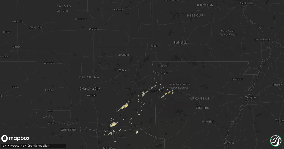
December 19 map
$229
one time, instant access
Download today. No call, no setup
Keep the $229
Bought the map and want the full workflow? Apply the entire $229 to a subscription within 7 days. None of it is wasted.
Every map, not just this one
This buys you this map. Subscription and you get every map we run, in the markets you choose from a few cities to whole states to nationwide. Plus real-time alerts the moment a storm fires.
Contact data
Name, contact info, occupancy, even credit band for addresses in the footprint. You go from where it hit to who to call.
Become the source they trust
Unlimited branding weather history reports on demand. You already have the documented answer ready for the property owner, and you are the one who showed up with it.
Property data and RoofTrace estimates
Pull up any address you have got, its value and the exact code rules for that jurisdiction, straight from One Click Code. Then RoofTrace estimates the squares, pitch, and roof value, priced the way you price.
Storm reports in Texas
Texas
| Date | Description |
|---|---|
| 12/19/20121:51 AM CST | Several trees reported down in the city. |
| 12/19/20121:10 AM CST | Trees down acros the county |
| 12/19/201212:55 AM CST | Trees and power lines down county wide. |
| 12/19/201212:50 AM CST | Trees and power lines down county wide. |
| 12/19/201212:35 AM CST | Trees and power lines down |
| 12/19/201212:30 AM CST | Trees and power lines down county wide. |
| 12/19/201212:30 AM CST | Strong winds blew the roof off a porch of a home on cr 3300 near the smithland community just north of highway 49. |
| 12/19/201212:15 AM CST | Trees and power lines down |
| 12/19/201212:06 AM CST | Large trees downed on hwy. 49 in kellyville northwest of jefferson. |
| 12/19/201212:05 AM CST | Roof off of a house. |
| 12/19/201212:05 AM CST | Numerous trees down. |
| 12/19/201212:00 AM CST | Trees and power lines down county wide. |
| 12/18/201211:54 PM CST | Trees down off cr157 and also fm322 2 ne through 4 nw of elkhart. Time estimated. |
| 12/18/201211:45 PM CST | Transformer reported down along highway 991 east. |
| 12/18/201211:40 PM CST | Report of large tree limbs and branches down due to very strong winds. |
| 12/18/201211:40 PM CST | Tree fell on house. |
| 12/18/201211:40 PM CST | Trees down off fm19 near neches. Time estimated. |
| 12/18/201211:40 PM CST | Tree across fm 2149 |
| 12/18/201211:35 PM CST | Trees down and debris on hwy. 80. |
| 12/18/201211:35 PM CST | Several trees downed across the entire county. Power lines downed as well. |
| 12/18/201211:30 PM CST | Trees reported down on cannon street. |
| 12/18/201211:25 PM CST | Power pole and wires across hwy 11. |
| 12/18/201211:20 PM CST | Tree down on hwy. 155. |
| 12/18/201211:15 PM CST | Tree down on mobile home. |
| 12/18/201211:10 PM CST | Tree down on house. |
| 12/18/201211:10 PM CST | Powelines reported down in town. |
| 12/18/201211:08 PM CST | Txdot reported trees down blocking roadway. Off hwy 19 north of athens. |
| 12/18/201210:55 PM CST | Numerous trees and power lines down across franklin county. |
| 12/18/201210:50 PM CST | Trees and large limbs down n of hwy 31 on fm1129 near roane and on airport runway pad at mildred 1030-11 pm. |
| 12/18/201210:45 PM CST | Trees and power lines down across red river county. |
| 12/18/201210:23 PM CST | Kslr reported |
| 12/18/201210:17 PM CST | Storms damaged 3 homes...2 barns...gas station and tire store in edgewood. Exact damage unkn at this time. |
| 12/18/201210:05 PM CST | Nw 0150/ranch road |
| 12/18/20129:56 PM CST | Dime to quarter sized hail in kaufman |
| 12/18/20129:55 PM CST | Estimated 65 to 70 mph winds in kaufman between 950 and 10 pm |
| 12/18/20129:31 PM CST | Powerlines down in farmersville |
| 12/18/20129:15 PM CST | Power lines down in garland |
| 12/18/20128:59 PM CST | 57 knot wind gust at dallas love field |
Cities Impacted by Hail Map on December 19, 2012
- Charleston, AR
- Branch, AR
- Antlers, OK
- Finley, OK
- Natural Dam, AR
- Keota, OK
- Mccurtain, OK
- Stigler, OK
- Gans, OK
- Mulberry, AR
- Bokchito, OK
- Bennington, OK
- Kenefic, OK
- Caddo, OK
- Mead, OK
- Durant, OK
- Colbert, OK
- Sherman, TX
- Denison, TX
- Wardville, OK
- Mcalester, OK
- Kiowa, OK
- Stuart, OK
- Blanco, OK
- Savanna, OK
- Jamesport, MO
- Trenton, MO
- Fort Smith, AR
- Greenwood, AR
- Huntington, AR
- Booneville, AR
- Mansfield, AR
- Pittsburg, TX
- Gilmer, TX
- Jacksonville, TX
- Rusk, TX
- Atoka, OK
- Lane, OK
- Muldrow, OK
- Ratcliff, AR
- Ozark, AR
- Paris, AR
- Coleman, OK
- Wapanucka, OK
- Milburn, OK
- Trenton, TX
- Cecil, AR
- Subiaco, AR
- Mountainburg, AR
- Gallatin, MO
- Paris, TX
- Sallisaw, OK
- Coalgate, OK
- Athens, TX
- Kinta, OK
- Red Oak, OK
- Seagoville, TX
- Hugo, OK
- Van Buren, AR
- Blossom, TX
- Detroit, TX
- Nashoba, OK
- Hendrix, OK
- Magazine, AR
- Quinton, OK
- Sadler, TX
- Alma, AR
- Pottsboro, TX
- Kingston, OK
- Caney, OK
- Madill, OK
- Uniontown, AR
- Clayton, OK
- Rattan, OK
- Humphreys, MO
- Galt, MO
- Wister, OK
- Talihina, OK


