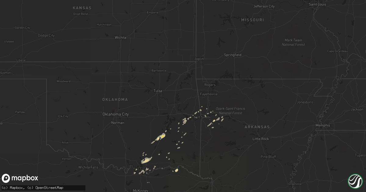
Hail Map in Arkansas on December 19, 2012
Get this storm
December 19 map
$229
one time, instant access
Download today. No call, no setup
Keep the $229
Bought the map and want the full workflow? Apply the entire $229 to a subscription within 7 days. None of it is wasted.
Every map, not just this one
This buys you this map. Subscription and you get every map we run, in the markets you choose from a few cities to whole states to nationwide. Plus real-time alerts the moment a storm fires.
Contact data
Name, contact info, occupancy, even credit band for addresses in the footprint. You go from where it hit to who to call.
Become the source they trust
Unlimited branding weather history reports on demand. You already have the documented answer ready for the property owner, and you are the one who showed up with it.
Property data and RoofTrace estimates
Pull up any address you have got, its value and the exact code rules for that jurisdiction, straight from One Click Code. Then RoofTrace estimates the squares, pitch, and roof value, priced the way you price.
Storm reports in Arkansas
Arkansas
| Date | Description |
|---|---|
| 12/19/20123:30 AM CST | Powerlines down in lake village. |
| 12/19/20122:45 AM CST | Tree limb knocked down part of shed. |
| 12/19/20122:40 AM CST | A tree was downed on river road toward preston ferry. Winds were estimated between 50 and 60 mph. |
| 12/19/20122:15 AM CST | Trees reported down in and around town. |
| 12/19/20121:55 AM CST | Trees reported down around el dorado...including one tree down on a home just north of town. |
| 12/19/20121:45 AM CST | Trees were downed at white hall with wind gusts estimated at 60 to 70 mph. |
| 12/19/20121:36 AM CST | Measured thundestorm wind gust from asos in el dorado. |
| 12/19/20121:30 AM CST | Trees and power lines were downed...with power outages noted. |
| 12/19/20121:25 AM CST | A possible brief tornado was spawned. Several houses and mobile homes were damaged. Some injuries were being reported. Numerous trees were downed and were blocking road |
| 12/19/20121:25 AM CST | *** 1 inj *** a possible brief tornado was spawned. A mobile home and several sheds were damaged or destroyed. One injury was reported. Numerous trees were downed...wit |
| 12/19/20121:25 AM CST | *** 1 inj *** an ef1 tornado has been confirmed by survey team. A double wide mobile home was destroyed. Survey team is continuing the survey and more details will beco |
| 12/19/20121:05 AM CST | Several trees down across highway 371. The highway is impassable at this time. |
| 12/19/201212:55 AM CST | Trees were downed in the area. |
| 12/19/201212:55 AM CST | Few trees reported down along highway 344 near mount vernon. |
| 12/19/201212:50 AM CST | Numerous trees reported down near highway 53 and walker creek...blocking a vehicle in place. |
| 12/19/201212:50 AM CST | Trees were downed in and around town. |
| 12/19/201212:45 AM CST | 3 trees reported down on highway 29 in canfield. |
| 12/19/201212:40 AM CST | Tree down on car |
| 12/19/201212:35 AM CST | Mobile home nearly destroyed due to damaging winds. Home was located near nevada county road 246 just west of the redland community. Four individuals were in the home a |
| 12/19/201212:35 AM CST | Trees were downed along highway 8 southwest of town. |
| 12/19/201212:30 AM CST | Tree reported down across interstate 30 at mile marker 48. |
| 12/19/201212:30 AM CST | Trees down on highway 29...blocking traffic while crews are removing them. |
| 12/19/201212:25 AM CST | A few trees were downed on county roads with power out at royal. |
| 12/19/201212:20 AM CST | Trees and power lines down county wide. |
| 12/19/201212:10 AM CST | Trees are down in harris brake lake along with the power being out. Trees are also down on westgate drive in perryville and in nimrod. |
| 12/19/201212:09 AM CST | Three barns were destroyed and the roofs of two houses were damaged. |
| 12/19/201212:00 AM CST | Roof or structural damage reported in texarkana arkansas. |
| 12/19/201212:00 AM CST | A few trees were downed in and around town. |
| 12/18/201211:57 PM CST | 51 knot gust reported at the ktxk asos. |
| 12/18/201211:35 PM CST | Trees and power lines down county wide. |
| 12/18/201211:30 PM CST | Trees were downed along highway 7. |
| 12/18/201211:30 PM CST | Damage reported to the front porch and chimney of a house. |
| 12/18/201211:20 PM CST | Trees and power lines down county wide. |
| 12/18/201211:20 PM CST | Structural damage to several properties. |
| 12/18/201211:15 PM CST | Tree reported down on a house. |
| 12/18/201210:55 PM CST | A roof was damaged on a home in hagarville. |
| 12/18/201210:40 PM CST | Trees were downed at y city. |
| 12/18/201210:40 PM CST | Trees were downed along highway 80 east of waldron. |
| 12/18/201210:20 PM CST | A storm chaser measured a 63 mph gust. |
| 12/18/201210:20 PM CST | A local report indicates 1.25 inch wind near CAULKSVILLE |
| 12/18/201210:19 PM CST | South of oak bend/etna area along franklin and logan county line. |
| 12/18/201210:10 PM CST | Quarter to half dollar size hail reported. Also est. 65 mph wind gust. |
| 12/18/20129:48 PM CST | Several homes and fire station damaged in the community of riverdale. Nws tulsa will send a survey team to the area tomorrow to determine if the damage was from a torna |
| 12/18/20129:48 PM CST | Mobile home was damaged from a tornado. |
| 12/18/20129:29 PM CST | Measured 63 mph wind at the fort smith regional airport. |
| 12/18/20129:25 PM CST | Twitter pic from kfsm shows awning off of gas station near zero and wheeler in fort smith. An ice machine was tossed across the street from the walmart on zero. Time es |
Cities Impacted by Hail Map on December 19, 2012
- Charleston, AR
- Branch, AR
- Antlers, OK
- Finley, OK
- Natural Dam, AR
- Keota, OK
- Mccurtain, OK
- Stigler, OK
- Gans, OK
- Mulberry, AR
- Bokchito, OK
- Bennington, OK
- Kenefic, OK
- Caddo, OK
- Mead, OK
- Durant, OK
- Colbert, OK
- Sherman, TX
- Denison, TX
- Wardville, OK
- Mcalester, OK
- Kiowa, OK
- Stuart, OK
- Blanco, OK
- Savanna, OK
- Jamesport, MO
- Trenton, MO
- Fort Smith, AR
- Greenwood, AR
- Huntington, AR
- Booneville, AR
- Mansfield, AR
- Pittsburg, TX
- Gilmer, TX
- Jacksonville, TX
- Rusk, TX
- Atoka, OK
- Lane, OK
- Muldrow, OK
- Ratcliff, AR
- Ozark, AR
- Paris, AR
- Coleman, OK
- Wapanucka, OK
- Milburn, OK
- Trenton, TX
- Cecil, AR
- Subiaco, AR
- Mountainburg, AR
- Gallatin, MO
- Paris, TX
- Sallisaw, OK
- Coalgate, OK
- Athens, TX
- Kinta, OK
- Red Oak, OK
- Seagoville, TX
- Hugo, OK
- Van Buren, AR
- Blossom, TX
- Detroit, TX
- Nashoba, OK
- Hendrix, OK
- Magazine, AR
- Quinton, OK
- Sadler, TX
- Alma, AR
- Pottsboro, TX
- Kingston, OK
- Caney, OK
- Madill, OK
- Uniontown, AR
- Clayton, OK
- Rattan, OK
- Humphreys, MO
- Galt, MO
- Wister, OK
- Talihina, OK


