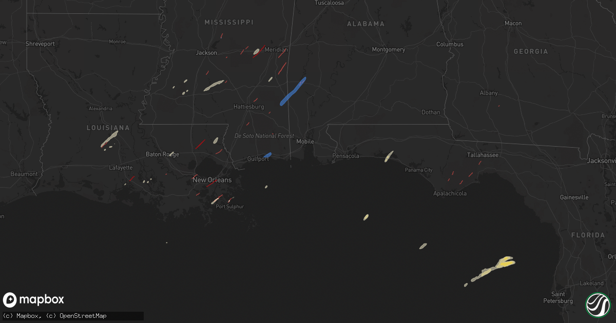
Hail Map on December 14, 2022
Get this storm
December 14 map
$229
one time, instant access
Download today. No call, no setup
Keep the $229
Bought the map and want the full workflow? Apply the entire $229 to a subscription within 7 days. None of it is wasted.
Every map, not just this one
This buys you this map. Subscription and you get every map we run, in the markets you choose from a few cities to whole states to nationwide. Plus real-time alerts the moment a storm fires.
Contact data
Name, contact info, occupancy, even credit band for addresses in the footprint. You go from where it hit to who to call.
Become the source they trust
Unlimited branding weather history reports on demand. You already have the documented answer ready for the property owner, and you are the one who showed up with it.
Property data and RoofTrace estimates
Pull up any address you have got, its value and the exact code rules for that jurisdiction, straight from One Click Code. Then RoofTrace estimates the squares, pitch, and roof value, priced the way you price.
States Impacted by Hail Map on December 14, 2022
Storm reports
Florida
| Date | Description |
|---|---|
| 12/14/20226:46 AM CST | At 1245 PM CST, a severe thunderstorm was located near Santa Rosa Beach, moving northeast at 25 mph. HAZARD...60 mph wind gusts. SOURCE...Radar indicated. IMPACT...Expect damage to roofs, siding, and trees. Locations impacted include... Santa Rosa Beach, Eglin Air Force Base, Freeport, Bruce, Portland, Port Washington, Bunker, Grayton Beach, Blue Mountain Beach, Seagrove Beach and Seaside. |
| 12/14/20225:55 AM CST | At 1154 PM CST, severe thunderstorms were located along a line extending from near Eglin Air Force Base to 15 miles south of Destin, moving northeast at 45 mph. HAZARD...60 mph wind gusts. SOURCE...Radar indicated. IMPACT...Expect damage to roofs, siding, and trees. Locations impacted include... Panama City, Lynn Haven, Panama City Beach, Santa Rosa Beach, Eglin Air Force Base, Live Oak, Freeport, Ebro, Portland, St Andrews State Park, Southport, Villa Tasso, Seminole Hills, Gulf Resort Beach, Blue Mountain Beach, West Panama City, Seaside, Bahama Beach, Holmes Valley and Biltmore Beach. |
| 12/14/20222:22 AM CST | At 822 PM EST/722 PM CST/, a severe thunderstorm was located 9 miles east of Cottonwood, moving northeast at 30 mph. HAZARD...60 mph wind gusts. SOURCE...Radar indicated. IMPACT...Expect damage to roofs, siding, and trees. Locations impacted include... Centerville, Gordon, Jakin, Saffold, Crosby, Grangeburg, Howards Mill, Rock Hill, Killarney, Chattahoochee SP, Lucy, Farley Nuclear Plant, Cedar Springs, Hilton, Sawhatchee and Pansey. |
| 12/14/20222:15 AM CST | Power outage affecting 22 customers along maddox road likely due to wind. |
| 12/14/20222:05 AM CST | At 805 PM CST, a severe thunderstorm was located near Santa Rosa Beach, moving northeast at 40 mph. HAZARD...60 mph wind gusts and quarter size hail. SOURCE...Radar indicated. IMPACT...Hail damage to vehicles is expected. Expect wind damage to roofs, siding, and trees. Locations impacted include... Santa Rosa Beach, De Funiak Springs, Eglin Air Force Base, Freeport, Douglass Crossroad, Portland, Villa Tasso, De Funiak Spring Airport, Rock Hill, Miramar Beach, Eucheeanna, Pleasant Ridge, Gulf Pines, New Home, Knox Hill, Argyle, Sandestin, Mossy Head, Four Mile Village and Alpine Heights. |
| 12/14/20221:49 AM CST | Power outage affecting 45 customers likely due to wind near compass lake. |
| 12/14/20221:41 AM CST | At 740 PM EST, a severe thunderstorm was located 12 miles southwest of Apalachicola, moving northeast at 25 mph. HAZARD...60 mph wind gusts. SOURCE...Radar indicated. IMPACT...Expect damage to roofs, siding, and trees. Locations impacted include... Carrabelle, St George Island, Eastpoint, Apalachicola, Franklin, Nine Mile, Carrabelle Beach, Buck Siding, Royal Bluff, High Bluff, Yent Place, Eleven Mile, Tilton, Beverly, Green Point, Bay City, Apalachicola Airport, Creels, Hays Place and Fort Gadsden. |
| 12/14/20221:28 AM CST | At 728 PM CST, severe thunderstorms were located along a line extending from 3 miles northwest of McIntosh to 3 miles south of Theodore, moving northeast at 45 mph. HAZARD...60 mph wind gusts. SOURCE...Radar indicated. IMPACT...Expect damage to roofs, siding, and trees. Locations impacted include... Midtown Mobile, Downtown Mobile, Prichard, Daphne, Tillmans Corner, Fairhope, Saraland, Gulf Shores, Bay Minette, Atmore, Foley, Theodore, Chickasaw, Satsuma, Orange Beach, Spanish Fort, Robertsdale, Bayou La Batre, Creola and Point Clear. |
| 12/14/20221:16 AM CST | 58 mph gust at the weatherflow station at panama city beach. |
| 12/14/202212:56 AM CST | At 656 PM EST/556 PM CST/, severe thunderstorms were located along a line extending from 8 miles west of Port St. Joe to 20 miles south of Mexico Beach to 39 miles southwest of Apalachicola, moving northeast at 45 mph. HAZARD...60 mph wind gusts. SOURCE...Radar indicated. IMPACT...Expect damage to roofs, siding, and trees. Locations impacted include... Apalachicola, Port St. Joe, Mexico Beach, Wewahitchka, Orange, Honeyville, Chipola Cutoff, Eleven Mile, Odena, Cape San Blas, Indian Pass, Beverly, Milltown, Kern, Bay City, Willis Landing, Apalachicola Airport, Simmons Bayou, Hays Place and Dalkeith. |
| 12/14/202212:16 AM CST | At 615 PM EST/515 PM CST/, a severe thunderstorm was located 14 miles south of Port St. Joe, moving northeast at 20 mph. HAZARD...60 mph wind gusts. SOURCE...Radar indicated. IMPACT...Expect damage to roofs, siding, and trees. Locations impacted include... Apalachicola, Nine Mile, Bay City, Eleven Mile, Thirteen Mile, Apalachicola Airport, Odena, Indian Pass, Tilton, Jones Homestead and Simmons Bayou. |
| 12/13/202211:59 PM CST | At 559 PM CST, a severe thunderstorm was located near Vernon, moving northeast at 25 mph. HAZARD...60 mph wind gusts. SOURCE...Radar indicated. IMPACT...Expect damage to roofs, siding, and trees. Locations impacted include... Vernon, Chipley, Marianna, Graceville, Bradford, Cottondale, Alford, Wausau, Richter Crossroads, Holmes Valley, Jacobs, Smyrna, Bahoma, Sylvania, Johnson Crossroads, Brock Crossroad, Jacob City, Chipley Municipal Airport, Orange Hill and Kynesville. |
| 12/13/202211:10 PM CST | At 510 PM CST, a severe thunderstorm was located 10 miles northwest of Panama City Beach, moving northeast at 30 mph. HAZARD...60 mph wind gusts. SOURCE...Radar indicated. IMPACT...Expect damage to roofs, siding, and trees. Locations impacted include... Live Oak, Ebro, West Bay, Seminole Hills, Greenhead, Bruce, Red Head, Millers Ferry, Pine Log, Sunnyside, Laird, Laguna Beach, Hollywood Beach and Riverside. |
| 12/13/202210:39 PM CST | At 438 PM CST, a severe thunderstorm was located 15 miles west of Panama City Beach, moving northeast at 25 mph. HAZARD...60 mph wind gusts. SOURCE...Radar indicated. IMPACT...Expect damage to roofs, siding, and trees. Locations impacted include... Panama City Beach, West Bay, Inlet Beach, Seminole Hills, Port Washington, Seaside, Pine Log, Sunnyside, Bunker, Laird, Laguna Beach, Hollywood Beach and Seagrove Beach. |
| 12/13/20229:15 PM CST | Trees down on road reported by emergency manager. |
| 12/13/20229:00 PM CST | Holmes county so dispatch received calls of possible tornado touchdown on walton county rd 183. |
| 12/13/20228:45 PM CST | Large power outage reported southeast of de funiak springs. |
| 12/13/20228:37 PM CST | Two trees down on smith creek rd... Reported by trained storm spotter. |
| 12/13/20228:32 PM CST | Social media user from twitter reported trees down about one mile west of sopchoppy fl... Location is estimated. |
| 12/13/20227:56 PM CST | Tds located in franklin county. |
| 12/13/20227:20 PM CST | Power outages reported by utility company caused by fallen trees. |
| 12/13/20226:54 PM CST | Tds located in liberty county. |
Alabama
| Date | Description |
|---|---|
| 12/14/20225:45 PM CST | A tornado debris signature |
| 12/14/20223:24 PM CST | Structural damage to a home and a barn on al 17 and wright rd. Primarily roof damage. Possible tornado. |
| 12/14/20223:19 PM CST | Trees down. Roof damage to home and a barn. Vehicle damage. Possible tornado. |
| 12/14/20223:17 PM CST | Nws birmingham storm survey found damage consistent with an ef-1 tornado with estimated max winds of 90 mph near ward... Al. Most damage occurred on cty rd 9 near jessi |
| 12/14/20223:56 AM CST | At 956 PM CST, severe thunderstorms were located along a line extending from 6 miles southwest of Pinckard to near Hartford, moving northeast at 40 mph. HAZARD...60 mph wind gusts. SOURCE...Radar indicated. IMPACT...Expect damage to roofs, siding, and trees. Locations impacted include... Daleville, Cottonwood, Headland, Dothan, Fort Rucker, Hartford, Taylor, Midland City, Kinsey, Slocomb, Cowarts, Newton, Webb, Pinckard, Malvern, Rehobeth, Clayhatchee, Grimes, Avon and Newville. |
| 12/14/20223:29 AM CST | At 928 PM CST, a severe thunderstorm was located 7 miles north of Samson, or 13 miles east of Opp, moving northeast at 50 mph. HAZARD...60 mph wind gusts and penny size hail. SOURCE...Radar indicated. IMPACT...Expect damage to roofs, siding, and trees. Locations impacted include... Daleville, Enterprise, Fort Rucker, Ozark, Level Plains, New Brockton, Clayhatchee, Knox Field, Lucile, Gerald, Turner Crossroads, Central City, Clintonville, Goodman, Cairns Aaf, Camp Alaflo Bsa, Enterprise Municipal A/P, Lowe Army Heliport, Cool Springs and Kelly. |
| 12/13/202211:05 PM CST | At 505 PM CST, a severe thunderstorm was located over Andalusia, moving northeast at 30 mph. HAZARD...60 mph wind gusts. SOURCE...Radar indicated. IMPACT...Expect damage to roofs, siding, and trees. Locations impacted include... Andalusia, Brantley, River Falls, Rutledge, Dozier, Heath and Gantt. |
| 12/13/202210:10 PM CST | Some trees were reported down along highway 231 near midland city. |
| 12/13/20229:30 PM CST | Tree down reported by emergency manager. |
| 12/13/20229:30 PM CST | Corrects previous tornado report from 1 e holley store. Tree down reported by emergency manager. |
Mississippi
| Date | Description |
|---|---|
| 12/14/20225:56 PM CST | Reports of heavy tree damage near the va hospital. |
| 12/14/20225:20 PM CST | Reports of powerlines down on enchanted ave... Near mystic circle. |
| 12/14/20222:35 PM CST | Multiple structures damaged on clarke county road 4191. |
| 12/14/20222:33 PM CST | Two mobile homes damaged on 670 east of quitman. Numerous homes with minor damage and a house with partial roof removal. |
| 12/14/20222:33 PM CST | Heavy structural damage east of quitman on county road 670 and another structure is completely gone. |
| 12/14/20222:31 PM CST | Possible tornado damage at the intersection of county road 660 and county road 511. Heavy tree damage and roads blocked. |
| 12/14/20222:10 PM CST | Roof damage to structures and shed damage on shelby gressett rd. Possible tornado. |
| 12/14/20222:09 PM CST | Several trees down in the fellowship community. |
| 12/14/20221:56 PM CST | Utility lines downed near camp binachi rd and old hwy 19. Possible tornado. |
| 12/14/20221:55 PM CST | Roof blown off trailer near toomsuba. |
| 12/14/20221:43 PM CST | Trees and powerlines down. |
| 12/14/20221:20 PM CST | Corrects previous tstm wnd dmg report from 1 se heidelberg. Power pole down in heidelburg. |
| 12/14/202212:59 PM CST | Structural damage to houses at the intersection of pop runnels road and macedonia road in petal. |
| 12/14/202212:35 PM CST | Trees uprooted and homes damaged about 1 mile north of hickory ms along edwards road. |
| 12/14/202212:35 PM CST | Several trees uprooted and snapped along rose road in hickory... Just north of i-20. |
| 12/14/20227:11 AM CST | Poultry houses destroyed in open field. |
| 12/14/20226:48 AM CST | Four poultry homes destroyed on gaddis myers rd. |
| 12/14/20226:48 AM CST | At 1247 AM CST, a severe thunderstorm was located near Tolarville, or near Thornton, moving east at 35 mph. HAZARD...60 mph wind gusts and quarter size hail. SOURCE...Radar indicated. IMPACT...Hail damage to vehicles is expected. Expect wind damage to roofs, siding, and trees. This severe thunderstorm will be near... Brozville, Howard and Ebenezer around 100 AM CST. Lexington around 110 AM CST. Franklin around 115 AM CST. Bowling Green around 125 AM CST. Durant around 130 AM CST. Possumneck around 140 AM CST.Other locations impacted by this severe thunderstorm include Eden,West and Sallis. |
| 12/14/20226:34 AM CST | 4 greenhouses and 2 hay barns were damaged in the area near the intersection of rock hill rd and ms highway 18. Possible tornado. |
| 12/14/20226:21 AM CST | Damage to mobile homes off reservoir... Some destroyed. |
| 12/14/20226:16 AM CST | At 1216 AM CST, a severe thunderstorm was located near Wallace Ridge, or 15 miles northwest of Ferriday, moving northeast at 35 mph. HAZARD...60 mph wind gusts. SOURCE...Radar indicated. IMPACT...Expect damage to roofs, siding, and trees. This severe thunderstorm will be near... Lee Bayou around 1235 AM CST. Cooter Point around 1250 AM CST. Helena around 1255 AM CST.Other locations impacted by this severe thunderstorm include Gilbertand Sicily Island. |
| 12/14/20226:00 AM CST | Mobile homes damaged off of rock road. |
| 12/14/20221:17 AM CST | At 717 AM CST, a severe thunderstorm was located 10 miles southeast of Leakesville, moving northeast at 25 mph. HAZARD...60 mph wind gusts. SOURCE...Radar indicated. IMPACT...Expect damage to roofs, siding, and trees. Locations impacted include... Deer Park. |
| 12/14/20221:04 AM CST | At 704 AM CST, severe thunderstorms were located along a line extending from White Oak to near Magee, moving northeast at 45 mph. HAZARD...60 mph wind gusts. SOURCE...Radar indicated. IMPACT...Expect damage to roofs, siding, and trees. Severe thunderstorms will be near... White Oak around 710 AM CST. Burns around 720 AM CST. Raleigh and Homewood around 725 AM CST. Pineville around 740 AM CST.Other locations impacted by these severe thunderstorms includeSylvarena and Lake. |
| 12/13/202211:15 PM CST | At 514 AM CST, a severe thunderstorm was located 5 miles southeast of Tuckers Crossing, or 10 miles east of Ellisville, moving northeast at 25 mph. HAZARD...60 mph wind gusts. SOURCE...Radar indicated. IMPACT...Expect damage to roofs, siding, and trees. This severe thunderstorm will remain over mainly rural areas of northwestern Wayne County. |
| 12/13/202210:58 PM CST | At 457 PM CST, a severe thunderstorm was located 6 miles southwest of State Line, or 15 miles north of Leakesville, moving northeast at 40 mph. HAZARD...60 mph wind gusts. SOURCE...Radar indicated. IMPACT...Expect damage to roofs, siding, and trees. Locations impacted include... Millry and State Line. |
| 12/13/202210:43 PM CST | At 443 PM CST, severe thunderstorms were located along a line extending from 11 miles southwest of McLain to 4 miles east of Saucier, moving east at 45 mph. HAZARD...60 mph wind gusts. SOURCE...Radar indicated. IMPACT...Expect damage to roofs, siding, and trees. Locations impacted include... Lucedale, Leakesville and McLain. |
| 12/13/20229:56 PM CST | At 355 PM CST, a severe thunderstorm was located 13 miles southeast of Poplarville, moving northeast at 35 mph. HAZARD...60 mph wind gusts. SOURCE...Radar indicated. IMPACT...Expect damage to roofs, siding, and trees. Locations impacted include... Wiggins, Perkinston and McHenry. |
| 12/13/20229:43 PM CST | At 343 AM CST, severe thunderstorms were located along a line extending from 6 miles northwest of New Hope to near Garden City, moving east at 25 mph. HAZARD...60 mph wind gusts and penny size hail. SOURCE...Radar indicated. IMPACT...Expect damage to roofs, siding, and trees. Locations impacted include... Bude, Kirby, Garden City, New Hope, Hamburg, Roxie and Meadville. |
| 12/13/20229:35 PM CST | At 335 PM CST, a severe thunderstorm was located 5 miles south of Rock Hill, or 13 miles northwest of Wiggins, moving northeast at 30 mph. HAZARD...60 mph wind gusts and quarter size hail. SOURCE...Radar indicated. IMPACT...Hail damage to vehicles is expected. Expect wind damage to roofs, siding, and trees. Locations impacted include... Beaumont and New Augusta. |
| 12/13/20229:13 PM CST | At 312 PM CST, a severe thunderstorm was located over Lumberton, or 11 miles northeast of Poplarville, moving northeast at 35 mph. HAZARD...60 mph wind gusts. SOURCE...Radar indicated. IMPACT...Expect damage to roofs, siding, and trees. This severe thunderstorm will be near... Rock Hill around 335 PM CST. Brooklyn around 340 PM CST. Mclaurin around 345 PM CST. |
| 12/13/20228:36 PM CST | At 236 PM CST, a severe thunderstorm was located over Madisonville, or 8 miles south of Covington, moving northeast at 40 mph. HAZARD...60 mph wind gusts. SOURCE...Radar indicated. IMPACT...Expect damage to roofs, siding, and trees. Locations impacted include... Slidell, Picayune, Covington, Pearl River, Abita Springs, Madisonville, Lacombe, Pearlington and Slidell Airport.This includes the following Interstates... Interstate 10 in Louisiana between mile markers 266 and 273. Interstate 10 in Mississippi between mile markers 1 and 2. Interstate 12 between mile markers 58 and 84. Interstate 59 in Louisiana between mile markers 1 and 11. |
| 12/13/20228:36 PM CST | At 236 AM CST, severe thunderstorms were located along a line extending from near Fayette to near Natchez to 6 miles north of Big Bend, moving northeast at 35 mph. HAZARD...60 mph wind gusts and penny size hail. SOURCE...Radar indicated. IMPACT...Expect damage to roofs, siding, and trees. Locations impacted include... Natchez, Vidalia, Fayette, Union Church, Stanton, Hamburg, Kingston, Black Hawk, Lorman, Sibley, Slocum, Mcbride, Cranfield, Stampley, Red Lick, Deer Park, Church Hill, Mcnair, Blue Hill and Kirby. |
| 12/13/20227:50 PM CST | At 150 AM CST, a severe thunderstorm was located near Vaiden, or 8 miles southeast of Winona, moving northeast at 40 mph. HAZARD...60 mph wind gusts. SOURCE...Radar indicated. IMPACT...Expect damage to roofs, siding, and trees. This severe thunderstorm will be near... Poplar Creek around 155 AM CST. Kilmichael around 200 AM CST. Lodi around 210 AM CST. Eupora around 225 AM CST. Bellefontaine around 230 AM CST. Sherwood around 235 AM CST.Other locations impacted by this severe thunderstorm include FrenchCamp, Walthall and Weir. |
| 12/13/20227:31 PM CST | At 131 AM CST, a severe thunderstorm was located near Black Hawk, or 18 miles south of Monterey, moving northeast at 45 mph. HAZARD...60 mph wind gusts. SOURCE...Radar indicated. IMPACT...Expect damage to roofs, siding, and trees. This severe thunderstorm will be near... Slocum around 135 AM CST. Deer Park around 150 AM CST. Sibley around 155 AM CST. Natchez and Vidalia around 210 AM CST.Other locations impacted by this severe thunderstorm includeRidgecrest. |
Louisiana
| Date | Description |
|---|---|
| 12/14/20224:04 PM CST | Damage to buildings. |
| 12/14/20223:56 PM CST | Damage reported to structures. |
| 12/14/20223:56 PM CST | Reported powerlines down. |
| 12/14/20223:50 PM CST | *** 6 inj *** an ef2 tornado with a maximum wind speed of 125 mph and a maximum width of 175 yards touched down in jefferson parish and ended in st. Bernard. The tornad |
| 12/14/20223:05 PM CST | Reports of power poles snapped and trees down. |
| 12/14/20223:05 PM CST | Trees and powerlines down in the talisheek area. |
| 12/14/20223:05 PM CST | Reports of roof damage and powerlines down. |
| 12/14/20222:54 PM CST | Mesonet station xptn pontchartrain causeway. |
| 12/14/20222:54 PM CST | Fire department reported trees across highway 36. |
| 12/14/20222:23 PM CST | Law enforcement reporting calls about house damage in montz. |
| 12/14/20222:21 PM CST | *** 1 fatal... 8 inj *** confirmed ef2 tornado with max winds of 120 mph... Max width of 75 yards... And a length of 5 miles. Several mobile homes were damaged or destr |
| 12/14/20222:21 PM CST | Confirmed damage along schoolhouse road with a house damaged... Power poles and street lights down. |
| 12/14/202212:02 PM CST | Two large oak trees reported down and damage to outer buildings. Possible tor. |
| 12/14/202212:00 PM CST | Numerous parish roads flooded. |
| 12/14/202211:59 AM CST | Spotter confirms tornado touched down west of donaldsonville. |
| 12/14/202210:55 AM CST | Medical center in new iberia sustained damage. |
| 12/14/202210:51 AM CST | Debris detected on radar. Skycam video of large tornado crossing 90 and admiral doyle into the south side of new iberia. |
| 12/14/202210:50 AM CST | Tornado damaged numerous homes... Outbuilds and the hospital. Tornado was 4.5 miles long and 300 yards wide. |
| 12/14/20229:23 AM CST | Picture of tornado in a field just west of la 29. |
| 12/14/20229:23 AM CST | Picture of tornado in a field just west of la 29. Survey team surveyed the area and found the exact location in the photo... However the tornado was in an marshy area a |
| 12/14/20226:54 AM CST | At 1254 AM CST, a severe thunderstorm was located near Larto, moving northeast at 25 mph. HAZARD...60 mph wind gusts. SOURCE...Radar indicated. IMPACT...Expect damage to roofs, siding, and trees. This severe thunderstorm will be near... Larto around 105 AM CST. New Era around 110 AM CST. Mayna around 115 AM CST. Monterey around 130 AM CST. Jonesville around 140 AM CST. |
| 12/14/20226:26 AM CST | At 1226 PM CST, a severe thunderstorm was located over Natalbany, or near Hammond, moving northeast at 40 mph. HAZARD...60 mph wind gusts. SOURCE...Radar indicated. IMPACT...Expect damage to roofs, siding, and trees. Locations impacted include... Hammond, Franklinton, Folsom, Natalbany and Tickfaw. This includes Interstate 55 in Louisiana between mile markers 34 and38. |
| 12/14/20226:25 AM CST | At 1225 PM CST, a severe thunderstorm was located near Madisonville, or 9 miles southwest of Covington, moving northeast at 45 mph. HAZARD...60 mph wind gusts. SOURCE...Radar indicated. IMPACT...Expect damage to roofs, siding, and trees. Locations impacted include... Covington, Abita Springs, Madisonville, Sun and Bush. This includes Interstate 12 between mile markers 57 and 65. |
| 12/13/202210:57 PM CST | At 457 PM CST, a severe thunderstorm was located near Pearlington, or 9 miles southwest of Waveland, moving northeast at 40 mph. HAZARD...60 mph wind gusts. SOURCE...Radar indicated. IMPACT...Expect damage to roofs, siding, and trees. Locations impacted include... Gulfport, Biloxi, Ocean Springs, Long Beach, Bay St. Louis, Waveland, Diamondhead, St. Martin, D'iberville, Kiln, Pearlington, Lyman, Shoreline Park, Saucier and Gulfport Airport.This includes the following Interstates... Interstate 10 in Mississippi between mile markers 1 and 47. Interstate 110 in Mississippi between mile markers 1 and 4. |
| 12/13/20229:38 PM CST | At 338 PM CST, a severe thunderstorm was located near Stennis Space Center, or 8 miles northeast of Slidell, moving northeast at 35 mph. HAZARD...60 mph wind gusts. SOURCE...Radar indicated. IMPACT...Expect damage to roofs, siding, and trees. Locations impacted include... Gulfport, Bay St. Louis, Diamondhead, Kiln, Lyman, Stennis Space Center, Shoreline Park and Pearlington.This includes the following Interstates... Interstate 10 in Louisiana between mile markers 269 and 273. Interstate 10 in Mississippi between mile markers 1 and 34. Interstate 59 in Louisiana between mile markers 6 and 11. Interstate 59 in Mississippi between mile markers 1 and 2. |
| 12/13/20227:56 PM CST | At 156 AM CST, a severe thunderstorm was located near Port Gibson, or 25 miles southwest of Vicksburg, moving northeast at 40 mph. HAZARD...60 mph wind gusts and quarter size hail. SOURCE...Radar indicated. IMPACT...Hail damage to vehicles is expected. Expect wind damage to roofs, siding, and trees. This severe thunderstorm will be near... Port Gibson around 200 AM CST. Yokena around 215 AM CST. Rocky Springs around 220 AM CST. Reganton around 225 AM CST. |
| 12/13/20227:43 PM CST | At 142 AM CST, a severe thunderstorm was located over Poland, or 9 miles west of Effie, moving northeast at 50 mph. HAZARD...60 mph wind gusts and penny size hail. SOURCE...Radar indicated. IMPACT...Expect damage to roofs, siding, and trees. Locations impacted include... Effie, Deville, Poland, Centerpoint and Ruby. |
| 12/13/20227:11 PM CST | At 111 AM CST, a severe thunderstorm was located over Helena, or 19 miles northeast of Ferriday, moving east at 30 mph. HAZARD...60 mph wind gusts and half dollar size hail. SOURCE...Radar indicated. IMPACT...Hail damage to vehicles is expected. Expect wind damage to roofs, siding, and trees. This severe thunderstorm will be near... St. Joseph and Lake Bruin around 135 AM CST. Alcorn around 140 AM CST. |
Georgia
| Date | Description |
|---|---|
| 12/14/20224:27 AM CST | Brief tds on radar coincided with large amount of power outages from colquitt electric outage map in far nw colquitt county and southern worth county. |
Cities Impacted by Hail Map on December 14, 2022
- Franklinton, LA
- Bush, LA
- Bogalusa, LA
- Jeanerette, LA
- Mamou, LA
- Bunkie, LA
- Ville Platte, LA
- Eunice, LA
- Baton Rouge, LA
- Denham Springs, LA
- Walker, LA
- Opelousas, LA
- McCall Creek, MS
- Brookhaven, MS
- Mendenhall, MS
- Magee, MS
- Sontag, MS
- Newhebron, MS
- Pinola, MS
- Monticello, MS
- Silver Creek, MS
- Port Sulphur, LA
- Lafitte, LA
- New Iberia, LA
- Union Church, MS
- Miramar Beach, FL
- Santa Rosa Beach, FL
- Hazlehurst, MS
- Freeport, FL
- Shubuta, MS
- Newton, MS
- Hickory, MS
- Harrisville, MS
- Georgetown, MS
- Canton, MS
- Lake, MS
- Mount Olive, MS
- Chunky, MS
- Decatur, MS
- Folsom, LA
- Loranger, LA
- Hammond, LA
- Petal, MS
- Ovett, MS
- Quitman, MS
- La Place, LA
- Hahnville, LA
- Toomsuba, MS
- Meridian, MS
- Abita Springs, LA
- Gheens, LA
- Pelahatchie, MS
- Lumberton, MS
- Gretna, LA
- Harvey, LA
- Marrero, LA
- Arabi, LA
- New Orleans, LA
- Chalmette, LA
- Braithwaite, LA
- Beaumont, MS
- Silas, AL
- Eastpoint, FL
- Sopchoppy, FL
- Crawfordville, FL
- Tallahassee, FL
- Doerun, GA
- State Line, MS
- Coffeeville, AL
- Chatom, AL
- Frankville, AL
- Millry, AL
- Biloxi, MS
- Vancleave, MS
- Ocean Springs, MS
- Diberville, MS