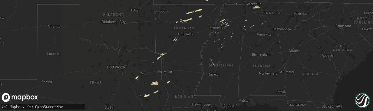
Hail Map in Mississippi on December 9, 2012
The weather event in Mississippi on December 9, 2012 includes Hail map. 8 states and 160 cities were impacted and suffered possible damage. The total estimated number of properties impacted is 0.
Want more than just the map?
Turn this storm into a full workflow.
- Owner + property data so you know who to knock
- OnDemand branded weather history reports to win the "did we even have hail?" argument
- RoofTrace estimate so reps stop guessing numbers at the door
Bought this map? Upgrade within 7 days and we'll credit the $230. (10-15 min setup call)
Hail
0
Estimated number of impacted properties by a 1.00" hail or larger0
Estimated number of impacted properties by a 1.75" hail or larger0
Estimated number of impacted properties by a 2.50" hail or largerStorm reports in Mississippi
Mississippi
| Date | Description |
|---|---|
| 12/09/20125:20 PM CST | A brief tornado touchdown took the medal roof off a building along weber jordan road.maximum winds were 85 mph and maximum width was 50 yards. The tornado was rated ef0 |
| 12/09/20124:15 PM CST | Shingle damage to a home and 2 trees down on vehicles along old hwy 11 near i-59 |
| 12/09/20124:15 PM CST | A brief tornado touch down caused shingle damage and broke a window on a house. Several trees were blown down...two of which fell on vehicles. The damage occurred along |
| 12/09/20123:50 PM CST | A pool was overturned and the public observed debris in the air and a funnel cloud near the interesection of interstate 12 and highway 53. Possible weak tornado. |
| 12/09/20123:50 PM CST | A weak tornado touched down a couple of times just south of poplarville causing minor property damage. A pool was overrturned and minor damage reported to a mobile home |
| 12/09/20125:25 AM CST | Tree downed across cranfield road |
| 12/09/20125:23 AM CST | Trees down along highway 28 just west of georgetown |
| 12/09/20124:00 AM CST | A tree fell on a trailer along gloster rd south of meadville |
| 12/09/20121:43 AM CST | Several trees down along with a patio damaged and a gazeebo flipped over. This occurred on lone oak dr just west of hwy 45. Also...a car wash on hwy 45 sustained some m |
| 12/09/20121:24 AM CST | Roof damage to an appartment along with some signs damaged. |
| 12/09/20121:20 AM CST | Several trees down in the west part of the county...one large tree was down across hwy 46. |
| 12/09/201212:57 AM CST | Trees down |
| 12/09/201212:35 AM CST | Several trees and power lines down. |
| 12/09/201212:10 AM CST | Trees down across power lines in carrollton and north carrollton...causing widespread power outages. Also...a roof was blown off an abndoned store |
| 12/09/201212:08 AM CST | A few trees down across hwy 17 south. |
All States Impacted by Hail Map on December 9, 2012
Cities Impacted by Hail Map on December 9, 2012
- Texarkana, AR
- Texarkana, TX
- Coffeeville, MS
- Williston, TN
- Somerville, TN
- Nesbit, MS
- Hernando, MS
- Lawrenceburg, TN
- Westpoint, TN
- Shelbyville, TN
- Linden, TN
- Daingerfield, TX
- Zavalla, TX
- Broaddus, TX
- Huntington, TX
- Athens, TX
- Montalba, TX
- Tennessee Colony, TX
- Larue, TX
- Higden, AR
- Drasco, AR
- Concord, AR
- Ida, AR
- Mason, TN
- Poughkeepsie, AR
- Smithville, AR
- Mountain View, AR
- Melbourne, AR
- Covington, TN
- Rusk, TX
- Brownsville, TN
- Garrison, TX
- Timpson, TX
- Center, TX
- Savannah, TN
- Black Rock, AR
- Imboden, AR
- Evening Shade, AR
- Ravenden, AR
- Grandin, MO
- Seguin, TX
- Nacogdoches, TX
- Douglass, TX
- Hector, AR
- Poplar Bluff, MO
- Annapolis, MO
- Tuckerman, AR
- Sallis, MS
- West, MS
- Fredericktown, MO
- Belzoni, MS
- Williford, AR
- Chandler, TX
- Brownsboro, TX
- College Station, TX
- Atoka, TN
- Munford, TN
- Brighton, TN
- Ripley, TN
- Cruger, MS
- Clinton, AR
- Shirley, AR
- Trinity, TX
- Groveton, TX
- Yazoo City, MS
- Sage, AR
- Swifton, AR
- Maud, TX
- Douglassville, TX
- Ringgold, LA
- Fifty Six, AR
- Atkins, AR
- Russellville, AR
- Waverly, TN
- Hurricane Mills, TN
- Joelton, TN
- Cumberland Furnace, TN
- Ashland City, TN
- Charlotte, TN
- Vanleer, TN
- Chapmansboro, TN
- Paris, MS
- Water Valley, MS
- Quitman, AR
- Pelican, LA
- Pleasant Hill, LA
- Converse, LA
- Batesville, MS
- Scotland, AR
- Cleveland, AR
- Corrigan, TX
- Palestine, TX
- Stanton, TN
- Linden, TX
- Hughes Springs, TX
- Bismarck, AR
- Ripley, MS
- Jerusalem, AR
- Hot Springs National Park, AR
- Bee Branch, AR
- Center Ridge, AR
- Moscow, TX
- Whiteville, TN
- Benton, MS
- Lexington, MS
- Edgemont, AR
- Locust Grove, AR
- Lovelady, TX
- Red Bay, AL
- Belmont, LA
- Zwolle, LA
- Marthaville, LA
- Coushatta, LA
- Williamsville, MO
- Doniphan, MO
- Wappapello, MO
- Coldwater, MS
- Tyler, TX
- Merryville, LA
- Marks, MS
- Clarksville, TN
- Pleasant View, TN
- Whites Creek, TN
- Blue Mountain, MS
- New Albany, MS
- Byhalia, MS
- Newport, AR
- Sidney, AR
- Horseshoe Bend, AR
- Mount Pleasant, AR
- Queen City, TX
- Lake Cormorant, MS
- Arlington, TN
- Marble Hill, MO
- Hope, AR
- Fulton, AR
- Medon, TN
- Mercer, TN
- Adamsville, TN
- Selmer, TN
- Stantonville, TN
- Benton, AR
- Lonsdale, AR
- Harviell, MO
- Sardis, MS
- Sedalia, KY
- Waterloo, AL
- Lutts, TN
- San Augustine, TX
- Grenada, MS
- Como, MS
- Bolivar, TN
- Donaldson, AR
- Malvern, AR
- Waskom, TX
- Marshall, TX
- Bastrop, TX
- Abbeville, MS
- Cornersville, TN
- Petersburg, TN


