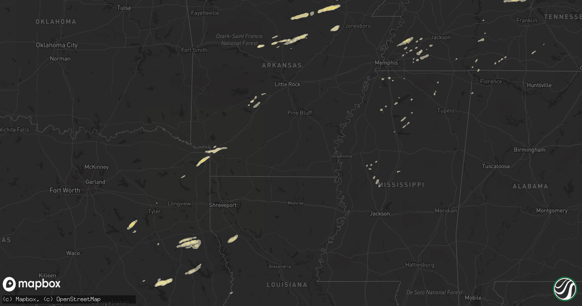
Hail Map in Arkansas on December 9, 2012
Get this storm
December 9 map
$229
one time, instant access
Download today. No call, no setup
Keep the $229
Bought the map and want the full workflow? Apply the entire $229 to a subscription within 7 days. None of it is wasted.
Every map, not just this one
This buys you this map. Subscription and you get every map we run, in the markets you choose from a few cities to whole states to nationwide. Plus real-time alerts the moment a storm fires.
Contact data
Name, contact info, occupancy, even credit band for addresses in the footprint. You go from where it hit to who to call.
Become the source they trust
Unlimited branding weather history reports on demand. You already have the documented answer ready for the property owner, and you are the one who showed up with it.
Property data and RoofTrace estimates
Pull up any address you have got, its value and the exact code rules for that jurisdiction, straight from One Click Code. Then RoofTrace estimates the squares, pitch, and roof value, priced the way you price.
Storm reports in Arkansas
Arkansas
| Date | Description |
|---|---|
| 12/09/20125:26 PM CST | The hail fell at the arkansas state police troop headquarters. |
| 12/09/20124:55 PM CST | A local report indicates 1.00 inch wind near TUCKERMAN |
| 12/09/20124:02 PM CST | Several trees were downed in the city of greenbrier. |
| 12/09/20124:01 PM CST | A local report indicates 1.00 inch wind near CONCORD |
| 12/09/20123:33 PM CST | Damage to several trees...hay barn and partially constructed home. |
| 12/09/20123:33 PM CST | Tornado on ground near imboden. Small debris field reported and measured wind gust of 59 miles per hour. |
| 12/09/20123:33 PM CST | House completely shifted off foundation. Second story of home removed along with roof. Neighbors barn in residents yard. |
| 12/09/20123:30 PM CST | Half dollar size hail and small tree limbs reported down by the public. |
| 12/09/20122:55 PM CST | A local report indicates 1.00 inch wind near 2 WSW HIGDEN |
| 12/09/20121:55 PM CST | A roof was blown off of an apartment building...as well as several mobile homes. There was also damage to outbuildings as well. |
| 12/09/201212:55 PM CST | *** 1 inj *** updated damage report...there was major damage to 3 mobile homes...one duplex...3 barns...and 4 outbuildings. Three families were displaced but are stayin |
| 12/08/20128:52 PM CST | Quarter size hail reported on highway 79 5 miles west of marianna. |
All States Impacted by Hail Map on December 9, 2012
Cities Impacted by Hail Map on December 9, 2012
- Texarkana, AR
- Texarkana, TX
- Coffeeville, MS
- Williston, TN
- Somerville, TN
- Nesbit, MS
- Hernando, MS
- Lawrenceburg, TN
- Westpoint, TN
- Shelbyville, TN
- Linden, TN
- Daingerfield, TX
- Zavalla, TX
- Broaddus, TX
- Huntington, TX
- Athens, TX
- Montalba, TX
- Tennessee Colony, TX
- Larue, TX
- Higden, AR
- Drasco, AR
- Concord, AR
- Ida, AR
- Mason, TN
- Poughkeepsie, AR
- Smithville, AR
- Mountain View, AR
- Melbourne, AR
- Covington, TN
- Rusk, TX
- Brownsville, TN
- Garrison, TX
- Timpson, TX
- Center, TX
- Savannah, TN
- Black Rock, AR
- Imboden, AR
- Evening Shade, AR
- Ravenden, AR
- Grandin, MO
- Seguin, TX
- Nacogdoches, TX
- Douglass, TX
- Hector, AR
- Poplar Bluff, MO
- Annapolis, MO
- Tuckerman, AR
- Sallis, MS
- West, MS
- Fredericktown, MO
- Belzoni, MS
- Williford, AR
- Chandler, TX
- Brownsboro, TX
- College Station, TX
- Atoka, TN
- Munford, TN
- Brighton, TN
- Ripley, TN
- Cruger, MS
- Clinton, AR
- Shirley, AR
- Trinity, TX
- Groveton, TX
- Yazoo City, MS
- Sage, AR
- Swifton, AR
- Maud, TX
- Douglassville, TX
- Ringgold, LA
- Fifty Six, AR
- Atkins, AR
- Russellville, AR
- Waverly, TN
- Hurricane Mills, TN
- Joelton, TN
- Cumberland Furnace, TN
- Ashland City, TN
- Charlotte, TN
- Vanleer, TN
- Chapmansboro, TN
- Paris, MS
- Water Valley, MS
- Quitman, AR
- Pelican, LA
- Pleasant Hill, LA
- Converse, LA
- Batesville, MS
- Scotland, AR
- Cleveland, AR
- Corrigan, TX
- Palestine, TX
- Stanton, TN
- Linden, TX
- Hughes Springs, TX
- Bismarck, AR
- Ripley, MS
- Jerusalem, AR
- Hot Springs National Park, AR
- Bee Branch, AR
- Center Ridge, AR
- Moscow, TX
- Whiteville, TN
- Benton, MS
- Lexington, MS
- Edgemont, AR
- Locust Grove, AR
- Lovelady, TX
- Red Bay, AL
- Belmont, LA
- Zwolle, LA
- Marthaville, LA
- Coushatta, LA
- Williamsville, MO
- Doniphan, MO
- Wappapello, MO
- Coldwater, MS
- Tyler, TX
- Merryville, LA
- Marks, MS
- Clarksville, TN
- Pleasant View, TN
- Whites Creek, TN
- Blue Mountain, MS
- New Albany, MS
- Byhalia, MS
- Newport, AR
- Sidney, AR
- Horseshoe Bend, AR
- Mount Pleasant, AR
- Queen City, TX
- Lake Cormorant, MS
- Arlington, TN
- Marble Hill, MO
- Hope, AR
- Fulton, AR
- Medon, TN
- Mercer, TN
- Adamsville, TN
- Selmer, TN
- Stantonville, TN
- Benton, AR
- Lonsdale, AR
- Harviell, MO
- Sardis, MS
- Sedalia, KY
- Waterloo, AL
- Lutts, TN
- San Augustine, TX
- Grenada, MS
- Como, MS
- Bolivar, TN
- Donaldson, AR
- Malvern, AR
- Waskom, TX
- Marshall, TX
- Bastrop, TX
- Abbeville, MS
- Cornersville, TN
- Petersburg, TN


