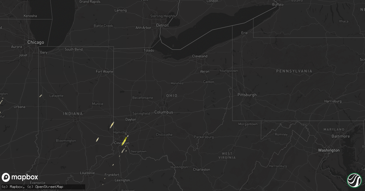
Hail Map in Ohio on December 1, 2018
Get this storm
December 1 map
$229
one time, instant access
Download today. No call, no setup
Keep the $229
Bought the map and want the full workflow? Apply the entire $229 to a subscription within 7 days. None of it is wasted.
Every map, not just this one
This buys you this map. Subscription and you get every map we run, in the markets you choose from a few cities to whole states to nationwide. Plus real-time alerts the moment a storm fires.
Contact data
Name, contact info, occupancy, even credit band for addresses in the footprint. You go from where it hit to who to call.
Become the source they trust
Unlimited branding weather history reports on demand. You already have the documented answer ready for the property owner, and you are the one who showed up with it.
Property data and RoofTrace estimates
Pull up any address you have got, its value and the exact code rules for that jurisdiction, straight from One Click Code. Then RoofTrace estimates the squares, pitch, and roof value, priced the way you price.
Storm reports in Ohio
Ohio
| Date | Description |
|---|---|
| 12/01/20184:35 AM CST | At 1035 PM EST, a severe thunderstorm was located 9 miles northeast of Ravenswood, or 9 miles southeast of Forked Run State Park, moving east at 75 mph. HAZARD...60 mph wind gusts and quarter size hail. SOURCE...Radar indicated. IMPACT...Hail damage to vehicles is expected. Expect wind damage to roofs, siding, and trees. Locations impacted include... Parkersburg, Elizabeth, Forked Run State Park, Mineralwells, North Bend State Park, Cairo, Portland, Smithville, Belleville, Reedsville, Walker, Nutter Farm, Petroleum, Palestine, Freeport, Davisville, Greencastle, Morristown, Rockport and Brohard.This includes the following highways... Interstate 77 in West Virginia between mile markers 151 and 172. Route 50 in West Virginia between mile markers 14 and 35. |
| 12/01/20181:46 AM CST | At 745 PM EST, a severe thunderstorm was located over Concorde Hills, moving northeast at 55 mph. HAZARD...Quarter size hail. SOURCE...Radar indicated. IMPACT...Minor damage to vehicles is possible. Locations impacted include... Cincinnati, Mason, Lebanon, Norwood, Sharonville, Monroe, Blue Ash, Loveland, Reading, Montgomery, Madeira, Milford, Deer Park, West Chester, Mariemont, Terrace Park, Morrow, Camp Dennison, Highpoint and Remington.This includes the following Interstates... I-71 in Ohio between mile markers 7 and 36. I-75 in Ohio between mile markers 10 and 14, and between milemarkers 22 and 29. |
| 11/30/20186:52 PM CST | A local report indicates 1.25 inch wind near DEER PARK |
| 11/30/20186:47 PM CST | A local report indicates 1.00 inch wind near MONTGOMERY |
| 11/30/20186:47 PM CST | A local report indicates 1.25 inch wind near KENWOOD |
| 11/30/20186:46 PM CST | A local report indicates 1.00 inch wind near 4 SSW BLUE ASH |
| 11/30/20186:45 PM CST | A local report indicates 1.00 inch wind near 1 N MADEIRA |
| 11/30/20186:44 PM CST | A local report indicates 1.00 inch wind near 4 SSW DEER PARK |
| 11/30/20186:43 PM CST | A local report indicates 1.00 inch wind near 2 SSE NORWOOD |
All States Impacted by Hail Map on December 1, 2018
Cities Impacted by Hail Map on December 1, 2018
- South Pekin, IL
- Pekin, IL
- Manito, IL
- Green Valley, IL
- Liberty, IN
- Brookville, IN
- Eaton, OH
- Camden, OH
- Girard, IL
- Waggoner, IL
- Sardis, MS
- Como, MS
- Hanna City, IL
- Elmwood, IL
- Glasford, IL
- Brimfield, IL
- Edwards, IL
- Trivoli, IL
- Canton, IL
- Huntsville, IL
- Clayton, IL
- Browning, IL
- Bath, IL
- Pleasant Plains, IL
- New Berlin, IL
- Springfield, IL
- Topeka, IL
- Forest City, IL
- Palmyra, IL
- Franklin, IL
- Waverly, IL
- Loveland, OH
- Maineville, OH
- Morrisonville, IL
- Harvel, IL
- Carrollton, IL
- Kane, IL
- Rockbridge, IL
- Fieldon, IL
- Alexandria, KY
- Cincinnati, OH
- Stonington, IL
- Niantic, IL
- Taylorville, IL
- Mount Auburn, IL
- Decatur, IL
- Harristown, IL
- Warrensburg, IL
- Blue Mound, IL
- Farmington, IL
- Yates City, IL
- Marion, AL
- Lyon, MS
- Sledge, MS
- Coahoma, MS
- Marks, MS
- Selma, AL
- Litchfield, IL
- Mount Olive, IL
- Staunton, IL
- Butler, IL
- Benld, IL
- Raymond, IL
- Edinburg, IL
- Palmer, IL
- Arlington, GA
- Morgan, GA
- Leary, GA
- Albany, GA
- Dry Branch, GA
- Jeffersonville, GA
- Bon Secour, AL
- Gulf Shores, AL
- Foley, AL
- Talladega, AL
- Defuniak Springs, FL
- Crestview, FL
- California, KY
- Medora, IL
- Jerseyville, IL
- Easton, IL
- Laurel Hill, FL
- Lewistown, IL
- Astoria, IL
- Havana, IL
- Oakfield, GA
- Leesburg, GA
- Munford, AL
- Lincoln, AL
- Enterprise, AL
- Watson, AR
- Tichnor, AR
- Dumas, AR
- Westville, FL
- Dayton, KY
- Newport, KY
- Fort Thomas, KY
- Macon, IL
- Kilbourne, IL
- Chandlerville, IL
- Cantrall, IL
- Loami, IL
- Greenfield, IL
- Beardstown, IL
- Frederick, IL
- Chambersburg, IL
- Versailles, IL
- Meredosia, IL
- Virden, IL
- Divernon, IL
- Auburn, IL
- Crumrod, AR
- Duncan, MS
- Crenshaw, MS
- Clarksdale, MS
- Snow Lake, AR
- Alligator, MS
- Tillar, AR
- Cochran, GA
- Samson, AL
- Coffee Springs, AL
- Melbourne, KY
- Ponce De Leon, FL
- Williamsport, IN
- Boswell, IN
- Ambia, IN
- Montevallo, AL
- Owenton, KY
- Dry Ridge, KY
- Osgood, IN
- Greensburg, IN
- Eglin Afb, FL
- Buffalo, IL
- Mechanicsburg, IL
- Griggsville, IL
- Illiopolis, IL
- Bluffton, GA
- Cuthbert, GA
- Edison, GA
- Fort Gaines, GA
- Coleman, GA
- Pinson, TN
- Oreana, IL
- Moulton, AL
- Danville, AL
- East Peoria, IL
- Groveland, IL
- Fidelity, IL
- Chesterfield, IL
- Lumpkin, GA
- Kathleen, GA
- Warner Robins, GA
- Bonaire, GA
- Amelia, OH
- Hartford, AL
- Holton, IN
- Waddy, KY
- Latonia, KY
- Bellevue, KY
- Clinton, IL
- Wapella, IL
- Morning View, KY
- De Mossville, KY
- Estill Springs, TN
- Elba, AL
- New Brockton, AL
- Daleville, AL
- Pensacola, FL
- Horse Cave, KY
- Munfordville, KY
- Florala, AL
- Ozark, AL
- Mason, OH
- West Chester, OH
- Caryville, FL
- Chaplin, KY
- Bloomfield, KY
- Maroa, IL
- Gould, AR
- Elberta, AL
- Lillian, AL
- Newville, AL
- Slocomb, AL
- Newton, AL
- Dothan, AL
- Midland City, AL
- Le Roy, IL
- Chancellor, AL
- Pawnee, IL
- Arenzville, IL
- Chapin, IL
- Dawson, IL
- Riverton, IL
- Rochester, IL
- Hettick, IL
- Carlinville, IL
- Blakely, GA
- Virginia, IL
- Senatobia, MS
- Mellwood, AR
- Pickens, AR
- Bowling Green, KY
- Oakland, KY
- Covington, KY
- Sarah, MS
- Farmersville, IL
- Beech Bluff, TN
- Jackson, TN
- Medon, TN


