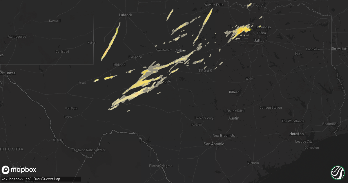
Hail Map in Texas on November 23, 2025
Get this storm
November 23 map
$229
one time, instant access
Download today. No call, no setup
Keep the $229
Bought the map and want the full workflow? Apply the entire $229 to a subscription within 7 days. None of it is wasted.
Every map, not just this one
This buys you this map. Subscription and you get every map we run, in the markets you choose from a few cities to whole states to nationwide. Plus real-time alerts the moment a storm fires.
Contact data
Name, contact info, occupancy, even credit band for addresses in the footprint. You go from where it hit to who to call.
Become the source they trust
Unlimited branding weather history reports on demand. You already have the documented answer ready for the property owner, and you are the one who showed up with it.
Property data and RoofTrace estimates
Pull up any address you have got, its value and the exact code rules for that jurisdiction, straight from One Click Code. Then RoofTrace estimates the squares, pitch, and roof value, priced the way you price.
Storm reports in Texas
Texas
| Date | Description |
|---|---|
| 11/23/20254:12 PM CST | Video shared on social media of nickel to quarter sized hail covering the side of the road and in grassy areas along fm 2371 west of andrews. Time estimated between 410 |
| 11/23/20254:49 AM CST | Report from mping: ping pong ball |
| 11/23/20254:36 AM CST | Several facebook reports of quarter size hail in ponder. |
| 11/23/20254:36 AM CST | Several facebook reports of quarter s |
| 11/23/20254:32 AM CST | Report from mping: quarter |
| 11/23/20254:31 AM CST | Facebook reports of mostly quarter size hail with some golfball size hail in north rhome. |
| 11/23/20254:29 AM CST | Quarter size hail reported for 3 minutes. |
| 11/23/20251:26 AM CST | A local report indicates 1.00 inch wind near 2 E Carlsbad |
| 11/22/20259:45 PM CST | Delayed report; near highway 36 in eula/clyde area. Location approximated. |
All States Impacted by Hail Map on November 23, 2025
Cities Impacted by Hail Map on November 23, 2025
- Rhine, GA
- Eastman, GA
- Sweetwater, TX
- Hermleigh, TX
- Monahans, TX
- Aspermont, TX
- Rule, TX
- Paducah, TX
- Old Glory, TX
- Haskell, TX
- Albany, TX
- Whiteface, TX
- Weinert, TX
- Breckenridge, TX
- Woodson, TX
- Throckmorton, TX
- Crane, TX
- Newcastle, TX
- Andrews, TX
- Olney, TX
- Seymour, TX
- Odessa, TX
- Holliday, TX
- Archer City, TX
- Scotland, TX
- Windthorst, TX
- Wichita Falls, TX
- Seminole, TX
- Seagraves, TX
- Midkiff, TX
- McCamey, TX
- Marlow, OK
- Brownfield, TX
- Welch, TX
- Rush Springs, OK
- Midland, TX
- Garden City, TX
- Tahoka, TX
- Meadow, TX
- Wolfforth, TX
- Sterling City, TX
- Roby, TX
- Bovina, TX
- Texico, NM
- Gainesville, TX
- Hamlin, TX
- Robert Lee, TX
- Stamford, TX
- Sylvester, TX
- McCaulley, TX
- Marietta, OK
- Anson, TX
- Bronte, TX
- Lueders, TX
- Avoca, TX
- Dryden, TX
- Wingate, TX
- Kenefic, OK
- Durant, OK
- Winters, TX
- Ovalo, TX
- Tuscola, TX
- Caney, OK
- Caddo, OK
- Lawn, TX
- Abilene, TX
- Atoka, OK
- Clyde, TX
- San Angelo, TX
- Baird, TX
- Christoval, TX
- Ballinger, TX
- Eldorado, TX
- Ozona, TX
- Big Lake, TX
- Fort Stockton, TX
- Iraan, TX
- Coleman, TX
- Burkett, TX
- Cross Plains, TX
- Mertzon, TX
- Rising Star, TX
- Sheffield, TX
- Carbon, TX
- Miles, TX
- Norton, TX
- Carlsbad, TX
- Barnhart, TX
- Talpa, TX
- Goldsboro, TX
- Moran, TX
- Goodfellow Afb, TX
- Cisco, TX
- Caddo, TX
- Ranger, TX
- Strawn, TX
- Graford, TX
- Poolville, TX
- Perrin, TX
- Weatherford, TX
- Jacksboro, TX
- Whitt, TX
- Millsap, TX
- Paradise, TX
- Chico, TX
- Bridgeport, TX
- Springtown, TX
- Azle, TX
- Boyd, TX
- Decatur, TX
- Gorman, TX
- Gordon, TX
- Stephenville, TX
- Mingus, TX
- Rhome, TX
- Early, TX
- Blanket, TX
- May, TX
- Newark, TX
- Haslet, TX
- Alvord, TX
- Desdemona, TX
- Sidney, TX
- Ponder, TX
- Justin, TX
- Comanche, TX
- Fort Worth, TX
- Argyle, TX
- Krum, TX
- Denton, TX
- Roanoke, TX
- Lewisville, TX
- Flower Mound, TX
- Gustine, TX
- Dublin, TX
- Gunter, TX
- Celina, TX
- Lake Dallas, TX
- Howe, TX
- Hico, TX
- Prosper, TX
- Frisco, TX
- Mckinney, TX
- Anna, TX
- Melissa, TX
- Aubrey, TX
- Southlake, TX
- Keller, TX


