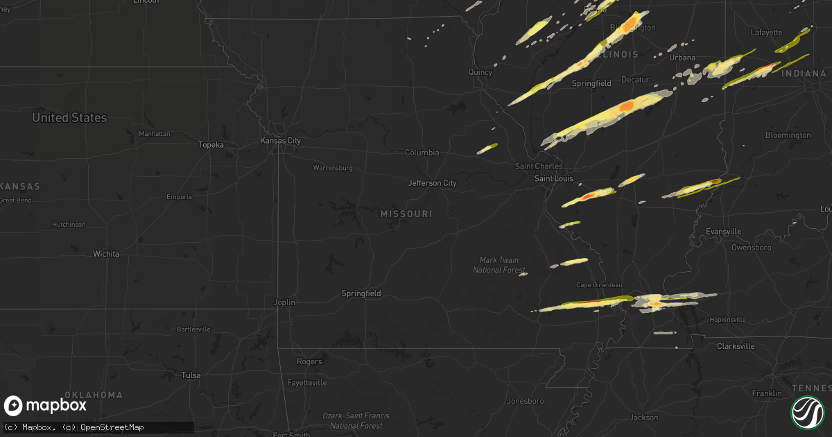
Hail Map in Missouri on November 17, 2013
Get this storm
November 17 map
$229
one time, instant access
Download today. No call, no setup
Keep the $229
Bought the map and want the full workflow? Apply the entire $229 to a subscription within 7 days. None of it is wasted.
Every map, not just this one
This buys you this map. Subscription and you get every map we run, in the markets you choose from a few cities to whole states to nationwide. Plus real-time alerts the moment a storm fires.
Contact data
Name, contact info, occupancy, even credit band for addresses in the footprint. You go from where it hit to who to call.
Become the source they trust
Unlimited branding weather history reports on demand. You already have the documented answer ready for the property owner, and you are the one who showed up with it.
Property data and RoofTrace estimates
Pull up any address you have got, its value and the exact code rules for that jurisdiction, straight from One Click Code. Then RoofTrace estimates the squares, pitch, and roof value, priced the way you price.
Storm reports in Missouri
Missouri
| Date | Description |
|---|---|
| 11/17/20132:12 PM CST | Several homes damaged along county road 511. Numerous trees down. State police responding. |
| 11/17/20131:18 PM CST | Mobile home destroyed. Sheriff office without power/communications. |
| 11/17/20131:07 PM CST | Ef 3 tornado. 3.5 miles nw of vanduser to 4.5 miles ne of blodgett. Peak wind 140 mph. Max path width 600 yards. Path length 19 miles. 2 stick built homes destroyed. On |
| 11/17/201312:51 PM CST | Gradient wind. |
| 11/17/201312:26 PM CST | Ef0 tornado. Peak winds 70 mph. Path width 50 yards. Path length 150 yards. Numerous small to medium trees and tree limbs either down or snapped. Brief touchdown. |
| 11/17/201312:15 PM CST | Multiple trees down some as big as twelve inches in diameter. |
| 11/17/201311:42 AM CST | Minor shingle and fascia damage across south st. Louis city |
| 11/17/201311:40 AM CST | Large tree uprooted at the 4500 block of magnolia. |
| 11/17/201311:39 AM CST | Large branch down damage to motor vehicle. |
| 11/17/201311:35 AM CST | Near cuivre river state park...a couple 10-12 inch diamter trees snapped along with dime size hail |
| 11/17/201311:30 AM CST | Seperate reports of 60 to 70 mph gusts near i270 and dougherty ferry and dime size hail |
| 11/17/201311:30 AM CST | Minor roof damage. Shingles blown off a few homes. |
| 11/17/201310:30 AM CST | Foot in diameter tree blown down. |
All States Impacted by Hail Map on November 17, 2013
Cities Impacted by Hail Map on November 17, 2013
- Joy, IL
- New Boston, IL
- Morrisonville, IL
- Nokomis, IL
- Ledbetter, KY
- Paducah, KY
- Rosamond, IL
- Modoc, IL
- Cedar, MI
- Marissa, IL
- Addieville, IL
- Oregon, IL
- Oak Creek, WI
- Franklin, WI
- Caledonia, WI
- Burlington, WI
- Kansasville, WI
- Franksville, WI
- South Milwaukee, WI
- Waterford, WI
- Union Grove, WI
- Cudahy, WI
- Ashton, IL
- Chana, IL
- Oran, MO
- Davis Junction, IL
- Rockford, IL
- Stillman Valley, IL
- West Salem, IL
- Saint Francisville, IL
- Mount Erie, IL
- Bone Gap, IL
- Mount Carmel, IL
- Albion, IL
- Allendale, IL
- Geneva, IL
- West Chicago, IL
- Batavia, IL
- Bloomington, IL
- Shirley, IL
- Pittsfield, IL
- Washington, IL
- Dana, IN
- Clinton, IN
- Puxico, MO
- Advance, MO
- Bloomfield, MO
- Bridgeview, IL
- Willow Springs, IL
- Hickory Hills, IL
- Justice, IL
- La Grange, IL
- Dixon, IA
- Raymond, IL
- Litchfield, IL
- Bethany, IL
- Moweaqua, IL
- Owaneco, IL
- Assumption, IL
- Harvel, IL
- Waggoner, IL
- Palmer, IL
- Taylorville, IL
- Findlay, IL
- Carlinville, IL
- Sullivan, IL
- Pana, IL
- Shelbyville, IL
- Gillespie, IL
- Nilwood, IL
- Columbus, WI
- Waterloo, WI
- Rutland, IL
- Minonk, IL
- Danvers, IL
- Atlanta, IL
- Stanford, IL
- Emden, IL
- Normal, IL
- Hudson, IL
- McLean, IL
- Armington, IL
- Minier, IL
- Towanda, IL
- Lexington, IL
- Canton, IL
- Utica, IL
- Ottawa, IL
- Sumner, IL
- Medora, IL
- Shipman, IL
- Illinois City, IL
- Muscatine, IA
- New Ross, IN
- Ladoga, IN
- New Market, IN
- Crawfordsville, IN
- Waveland, IN
- Petersburg, IL
- Hennepin, IL
- Putnam, IL
- Henry, IL
- McNabb, IL
- Granville, IL
- Magnolia, IL
- New Athens, IL
- Saint Libory, IL
- Nashville, IL
- Bartelso, IL
- New Baden, IL
- Hoyleton, IL
- Mascoutah, IL
- Okawville, IL
- Fruitland, IA
- Thornton, IL
- Glenwood, IL
- Homewood, IL
- Chicago Heights, IL
- Belvidere, IL
- West Paducah, KY
- Jerseyville, IL
- Arthur, IL
- Butler, IL
- Witt, IL
- Godfrey, IL
- Elsah, IL
- Dow, IL
- Tower Hill, IL
- Farmersville, IL
- Brighton, IL
- Arcola, IL
- Grafton, IL
- Chesterfield, IL
- Ohlman, IL
- Humboldt, IL
- Piasa, IL
- Lovington, IL
- Fidelity, IL
- Vermont, IL
- Williamsville, MO
- Frankfort, IN
- Walsh, IL
- Sainte Genevieve, MO
- Evansville, IL
- Ellis Grove, IL
- Prairie Du Rocher, IL
- Ashland, IL
- Greenview, IL
- Mason City, IL
- Jacksonville, IL
- Athens, IL
- New Holland, IL
- Virginia, IL
- Hartsburg, IL
- Tallula, IL
- High Hill, MO
- Truxton, MO
- Bellflower, MO
- New Florence, MO
- Montgomery City, MO
- Kokomo, IN
- Russiaville, IN
- Columbus Junction, IA
- Letts, IA
- Sandwich, IL
- Somonauk, IL
- Salem, IL
- Odin, IL
- Sandoval, IL
- Colfax, IN
- Princeville, IL
- Dana, IL
- Ancona, IL
- Kevil, KY
- Covington, IN
- Indianola, IL
- Perrysville, IN
- Westville, IL
- Cayuga, IN
- Danville, IL
- Ridge Farm, IL
- Georgetown, IL
- Littleton, IL
- Industry, IL
- Wappapello, MO
- Greenville, MO
- Wapello, IA
- Blue Grass, IA
- Fredonia, KY
- Marion, KY
- Princeton, KY
- Tiline, KY
- Eddyville, KY
- Metamora, IL
- Roanoke, IL
- Monee, IL
- Peotone, IL
- Manhattan, IL
- Wilmington, IL
- Murray, KY
- Almo, KY
- Reeseville, WI
- Peru, IL
- Oglesby, IL
- Cedar Point, IL
- Crest Hill, IL
- Joliet, IL
- Shorewood, IL
- Homer Glen, IL
- Lockport, IL
- Minooka, IL
- Channahon, IL
- Lemont, IL
- Genoa City, WI
- Lake Geneva, WI
- New Lenox, IL
- Elwood, IL
- Lowpoint, IL
- Donnellson, IA
- West Point, IA
- Brookport, IL
- Metropolis, IL
- Lenzburg, IL
- Waterloo, IL
- Hecker, IL
- Red Bud, IL
- Freeburg, IL
- Griggsville, IL
- East Peoria, IL
- Peoria, IL
- Mapleton, IL
- Creve Coeur, IL
- Pekin, IL
- Washburn, IL
- Lacon, IL
- Lowell, WI
- Beaver Dam, WI
- Marshall, WI
- Watertown, WI
- Juneau, WI
- Adair, IL
- Macomb, IL
- Marietta, IL
- Annapolis, MO
- Ravenna, MI
- Chapin, IL
- Memphis, MO
- Manito, IL
- Kingman, IN
- Morris, IL
- Verona, IL
- Seneca, IL
- Mazon, IL
- Kinsman, IL
- Ransom, IL
- Middletown, IL
- Lincoln, IL
- Westmont, IL
- Willowbrook, IL
- Hinsdale, IL
- Clarendon Hills, IL
- Louisiana, MO
- Arbela, MO
- Longview, IL
- Sidney, IL
- Broadlands, IL
- Tuscola, IL
- Palatine, IL
- Schaumburg, IL
- Rolling Meadows, IL
- Arlington Heights, IL
- Sturdivant, MO
- Sedgewickville, MO
- Oak Ridge, MO
- Friedheim, MO
- Frohna, MO
- Patton, MO
- Uniontown, MO
- Perryville, MO
- Plymouth, IL
- Bushnell, IL
- Colchester, IL
- Avon, IL
- Smithfield, IL
- Princeton, IL
- Tiskilwa, IL
- Bluffs, IL
- Brimfield, IL
- Elmwood, IL
- Gifford, IL
- Standard, IL
- Chrisman, IL
- Baring, MO
- Iuka, IL
- Centralia, IL
- Mokena, IL
- Ellisville, IL
- Bluford, IL
- Mount Vernon, IL
- Puryear, TN
- Hazel, KY
- Milwaukee, WI
- Greendale, WI
- Saint Francis, WI
- Chillicothe, IL
- Sparland, IL
- Speer, IL
- Edelstein, IL
- Harvard, IL
- Garden Prairie, IL
- Camargo, IL
- Philo, IL
- Hume, IL
- Villa Grove, IL
- Allerton, IL
- Murdock, IL
- Tolono, IL
- Newman, IL
- Muskego, WI
- Racine, WI
- Rochester, WI
- Scott City, MO
- Old Appleton, MO
- Altenburg, MO
- Saint Charles, IL
- Streator, IL
- Charleston, MO
- Miller City, IL
- Sikeston, MO
- Bell City, MO
- Benton, MO
- Frankfort, IL
- Delavan, IL
- Chenoa, IL
- Scott Air Force Base, IL
- Lebanon, IL
- Toluca, IL
- Varna, IL
- Camden, IN
- Bowling Green, MO
- Long Point, IL
- Benson, IL
- Cornell, IL
- Wenona, IL
- Fredericktown, MO
- Mounds, IL
- McGee, MO
- Zalma, MO
- Cairo, IL
- De Witt, IA
- New Berlin, WI
- Hales Corners, WI
- Ipava, IL
- De Land, IL
- Mossville, IL
- Peru, IN
- Logansport, IN
- Winchester, IL
- Rockville, IN
- Hillsdale, IN
- Bloomingdale, IN
- Montezuma, IN
- Marshall, IN
- Mansfield, IL
- Matteson, IL
- University Park, IL
- Park Forest, IL
- Steger, IL
- Crete, IL
- Richton Park, IL
- Monroe Center, IL
- Cherry Valley, IL
- Edwards, IL
- Blackstone, IL
- Sidell, IL
- Paris, IL
- Roscoe, IL
- Sugar Grove, IL
- Aurora, IL
- Stonington, IL
- Lostant, IL
- Mound City, IL
- Barlow, KY
- Kirkland, IL
- Esmond, IL
- Malden, IL
- Arenzville, IL
- Rockport, IL
- Concord, IL
- Pleasant Hill, IL
- Homer, IL
- Glasford, IL
- Hanna City, IL
- Hanover Park, IL
- Bartlett, IL
- Rochelle, IL
- Greentop, MO
- Queen City, MO
- Farmington, KY
- Mayfield, KY
- Kirksey, KY
- Pecatonica, IL
- Winnebago, IL
- Poplar Grove, IL
- Kuttawa, KY
- Smithland, KY
- Calvert City, KY
- Grand Rivers, KY
- Veedersburg, IN
- Fairmount, IL
- Catlin, IL
- Metcalf, IL
- Maple City, MI
- Pesotum, IL
- Cambridge, IL
- Cuba, IL
- Saint David, IL
- Bryant, IL
- Lewistown, IL
- Arcadia, MO
- Caledonia, IL
- Loves Park, IL
- Lake Forest, IL
- Deerfield, IL
- Highland Park, IL
- Walcott, IA
- Donahue, IA
- Durant, IA
- Wilton, IA
- Stockton, IA
- Linton, IN
- Lake Leelanau, MI
- Wheeling, IL
- Buffalo Grove, IL
- Lansing, IL
- Calumet City, IL
- Munster, IN
- South Holland, IL
- Peoria Heights, IL
- Plano, IL
- Big Rock, IL
- Fisher, IL
- Champaign, IL
- Dewey, IL
- Mahomet, IL
- Thomasboro, IL
- Rantoul, IL
- Woodridge, IL
- Darien, IL
- Bolingbrook, IL
- Downers Grove, IL
- Forest, IN
- Camp Point, IL
- Coatsburg, IL
- Woodhull, IL
- Suttons Bay, MI
- Northport, MI
- Lesterville, MO
- Salem, KY
- La Center, KY
- Dawson Springs, KY
- Cunningham, KY
- Burna, KY
- Boaz, KY
- Long Grove, IA
- Golden, IL
- Tonica, IL
- La Salle, IL
- Orland Park, IL
- Sims, IL
- Golden Gate, IL
- Geff, IL
- Fairfield, IL
- Hillside, IL
- Oak Brook, IL
- Westchester, IL
- Elmhurst, IL
- Bluffton, IN
- Battletown, KY
- Coal City, IL
- Camanche, IA
- Clinton, IA
- Montpelier, IA
- Taylor Ridge, IL
- Vincennes, IN
- Cisne, IL
- Decker, IN
- Wheatland, IN
- Monroe City, IN
- Ellery, IL
- Olmsted, IL
- Villa Ridge, IL
- Brownwood, MO
- Thebes, IL
- Morton, IL
- Eureka, IL
- Meredosia, IL
- Carlyle, IL
- Hawk Point, MO
- Silex, MO
- Sparta, IL
- Clinton, WI
- Sharon, WI
- Darien, WI
- Delavan, WI
- Walworth, WI
- Sheridan, IL
- Serena, IL
- Braidwood, IL
- Braceville, IL
- Mellott, IN
- New Richmond, IN
- Wingate, IN
- Jamestown, IN
- Advance, IN
- Whitestown, IN
- Sheridan, IN
- Lebanon, IN
- Thorntown, IN
- Michigantown, IN
- Clarks Hill, IN


