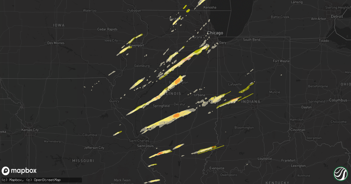
Hail Map in Illinois on November 17, 2013
Get this storm
November 17 map
$229
one time, instant access
Download today. No call, no setup
Keep the $229
Bought the map and want the full workflow? Apply the entire $229 to a subscription within 7 days. None of it is wasted.
Every map, not just this one
This buys you this map. Subscription and you get every map we run, in the markets you choose from a few cities to whole states to nationwide. Plus real-time alerts the moment a storm fires.
Contact data
Name, contact info, occupancy, even credit band for addresses in the footprint. You go from where it hit to who to call.
Become the source they trust
Unlimited branding weather history reports on demand. You already have the documented answer ready for the property owner, and you are the one who showed up with it.
Property data and RoofTrace estimates
Pull up any address you have got, its value and the exact code rules for that jurisdiction, straight from One Click Code. Then RoofTrace estimates the squares, pitch, and roof value, priced the way you price.
Storm reports in Illinois
Illinois
| Date | Description |
|---|---|
| 11/17/20133:06 PM CST | A local report indicates 64 MPH wind near LAWRENCEVILLE AIRPORT |
| 11/17/20131:59 PM CST | Numerous reports relayed through the em of tornado and funnel clouds. Tornadoes having brief touchdowns. Some damage reported. |
| 11/17/20131:53 PM CST | A local report indicates a tornado near 2 W PATTON |
| 11/17/20131:44 PM CST | *** 1 inj *** ef2 tornado from 7 n bellmont to 3 s of allendale. Peak wind 127 mph. Max path width 225 yds. Path length 10 miles. 4 mobile homes damaged/2 destroyed. Wo |
| 11/17/20131:43 PM CST | Tornado on the ground located 2w of lickpre church. Rotation visible on the ground. |
| 11/17/20131:41 PM CST | Crops flattened in multiple fields. |
| 11/17/20131:40 PM CST | ...confirmed by ema...one house destroyed and numerous power lines down. Widespread damaged reported throughout the middle of the county. |
| 11/17/20131:36 PM CST | At sheridan rd and south blvd. |
| 11/17/20131:35 PM CST | Downed tree limbs and small hail. |
| 11/17/20131:33 PM CST | Ef2 tornado started 6 mi nw of albion and ended 4 mi n of albion. Peak wind 112 mph. Max path width 100 yds. Path length 5 miles. This was one of two tornadoes that wer |
| 11/17/20131:30 PM CST | Shingles off roof. Tress down. |
| 11/17/20131:30 PM CST | A local report indicates 60 MPH wind near BOLINGBROOK |
| 11/17/20131:30 PM CST | Ef2 tornado began 7 mi nw of albion to 6 mi ne of albion. Peak wind 130 mph. Max path width 300 yds. Path length 8 miles. This was one of two tornadoes reported on the |
| 11/17/20131:30 PM CST | ...unconfirmed...reported along the border between scott and mississippi counties. |
| 11/17/20131:30 PM CST | Ef2 tornado started 6 mi nw of albion and ended 4 mi n of albion. Peak wind 112 mph. Max path width 100 yds. Path length 5 miles. This was one of two tornadoes that wer |
| 11/17/20131:29 PM CST | Ef2 tornado began 7 mi nw of albion to 6 mi ne of albion. Peak wind 130 mph. Max path width 300 yds. Path length 8 miles. This was one of two tornadoes reported on the |
| 11/17/20131:20 PM CST | At caton farm rd and county line rd. |
| 11/17/20131:20 PM CST | Cannon school in danville damaged. Numerous businesses damaged on vermilion street. |
| 11/17/20131:19 PM CST | This was from the november 17th event. An nws storm survey team determined an ef-0 tornado with maximum winds of 80 mph tracked 1.0 mile after entering from vermillion |
| 11/17/20131:19 PM CST | This was from the november 17th event. An nws storm survey determined an ef-0 tornado occurred with maximum winds of 80 mph. This tracked 4.6 miles. Four farmsteads wer |
| 11/17/20131:17 PM CST | Various sized branches down. Largest at 1.5 feet in diameter. Peak gust measured at 61 mph. |
| 11/17/20131:15 PM CST | Mobile home damaged. |
| 11/17/20131:15 PM CST | From 3 miles west of hoopeston to northeast to the iroquois county line...sporadic damage. Several barns severeley damaged. Irrigation system destroyed. Machine shed wi |
| 11/17/20131:15 PM CST | 2 over-turned semis at i-39 and i-88. |
| 11/17/20131:12 PM CST | Home damaged - large section of roof gone. Power pole down. |
| 11/17/20131:11 PM CST | A local report indicates 59 MPH wind near DUPAGE AIRPORT |
| 11/17/20131:11 PM CST | Widespread power outages. Trees and power poles down. High school in westville damaged. |
| 11/17/20131:11 PM CST | Half mile west of il route 1 on 1350 north |
| 11/17/20131:11 PM CST | Roof off house |
| 11/17/20131:11 PM CST | Two farms destoyed. |
| 11/17/20131:11 PM CST | A local report indicates 69 MPH wind near WESTVILLE |
| 11/17/20131:10 PM CST | 5 farm houses heavily damaged. |
| 11/17/20131:09 PM CST | Two farm homes damaged. |
| 11/17/20131:09 PM CST | At us-14 at mchenry college. |
| 11/17/20131:07 PM CST | Machine sheds heavily damaged. |
| 11/17/20131:05 PM CST | Brief ef1 touchdown. Peak wind 107 mph. Max path width 25 yds. Touchdown occurred on the north side of i-64. Several trees were snapped. |
| 11/17/20131:05 PM CST | *** 1 inj *** ef-2 tornado. Started 4 miles northwest of sidell...peak wind 130 mph...path length 18 miles...1/4 mile path width...end time 119 pm cst...ended at 4.5 mi |
| 11/17/20131:05 PM CST | A local report indicates 65 MPH wind near 2 NE WOODSTOCK |
| 11/17/20131:02 PM CST | Brief ef1 touchdown. Peak wind 107 mph. Max path width 25 yds. Touchdown occurred on the north side of i-64. Several trees were snapped. |
| 11/17/20131:01 PM CST | This was from the november 17th event. Brief ef-1 tornado with 0.8 mile path into will county destroyed a 35 foot tall well constructed barn...snapped several softwood |
| 11/17/20131:00 PM CST | Roof damage to house on mathews drive. Part of it landed in neighbors pool. Screened-in porch also room destroyed. |
| 11/17/20131:00 PM CST | Time approximate. Il-115 is closed between 1700 and 1600 west due to power line poles snapped off. |
| 11/17/20131:00 PM CST | Numerous power poles and trees down. Pole barn roof blown off. |
| 11/17/20131:00 PM CST | 3 to 8 inch limbs blown down near il-47 and keslinger rd. |
| 11/17/20131:00 PM CST | Tree on house on eagle street. Time estimated. |
| 11/17/201312:58 PM CST | House siding damaged.100 year oak tree cracked at base. Tree landed on neighbors garage. Golf course had many trees uprooted. |
| 11/17/201312:57 PM CST | From trained spotters |
| 11/17/201312:56 PM CST | Structural damage to buildings in town. |
| 11/17/201312:55 PM CST | Delayed report from university of chicago hospitals heliport. |
| 11/17/201312:53 PM CST | Mobile homes blown over |
| 11/17/201312:51 PM CST | Delayed report. 10 to 20 powerpoles snapped/down and 20 cross members down along 4000n between 6000e and 8000e. |
| 11/17/201312:50 PM CST | Delayed report. 2 older trees down on the north side of the oak club of genoa golf course. Esimtated wind speeds 60 mph. |
| 11/17/201312:50 PM CST | Numerous power poles and trees down. One house severely damaged with second floor removed. |
| 11/17/201312:50 PM CST | Roof damage to homes. Overturned mobile homes. Power lines down. |
| 11/17/201312:50 PM CST | Power lines down near il-23 and gurler rd. |
| 11/17/201312:48 PM CST | Several grain bins destroyed. Power lines down. Garage damaged. |
| 11/17/201312:46 PM CST | Ef-3 tornado. Started 6.4 miles west of villa grove...peak wind 140 mph...path length 15 miles...1/4 mile wide...ended at 1258 pm cst...ended at 2.5 miles northwest of |
| 11/17/201312:45 PM CST | Also had wind gust to 52 mph. |
| 11/17/201312:45 PM CST | At us-30 and gouger rd. |
| 11/17/201312:45 PM CST | *** 6 inj *** ef-3 tornado...peak wind 140 mph...28.7 miles in length...quarter mile wide. Started 2 miles east of thomasboro...ended 3.5 miles east northeast of east l |
| 11/17/201312:45 PM CST | Along harlem avenue |
| 11/17/201312:45 PM CST | Tornado crossed i-57 |
| 11/17/201312:45 PM CST | Large tree down on power lines in northwest section of town. |
| 11/17/201312:45 PM CST | Barn doors blown in. A few power poles blown down. Time is estimated. |
| 11/17/201312:42 PM CST | A local report indicates 75 MPH wind near OAK LAWN |
| 11/17/201312:42 PM CST | A confirmed ef-2 tornado touched down 3 miles se of manhattan il yesterday...sunday november 17th. The tornado was on the ground for 6 minutes...had a path length of 5. |
| 11/17/201312:40 PM CST | A local report indicates 70 MPH wind near SEYMOUR |
| 11/17/201312:39 PM CST | South of manhattan |
| 11/17/201312:38 PM CST | Delayed report. Barn on south side of 7000s between 8000w and 9000w with roof torn off and thrown in field across the street...and some barn debris thrown to the north/ |
| 11/17/201312:37 PM CST | A local report indicates 67 MPH wind near ROCHELLE |
| 11/17/201312:36 PM CST | Delayed report. Two older 8 to 10 inch diameter trees down. Winds esimated at up to 60 mph. |
| 11/17/201312:35 PM CST | Several south facing windows blown in of residence. Also roof blown off shed. Two power lines also down on 5000 south road between 16000 and 15000 west road which is cl |
| 11/17/201312:35 PM CST | Roof taken off of a closed gas station at 99th and cicero. Trees limbs and power lines down across town. |
| 11/17/201312:35 PM CST | A local report indicates 1.00 inch wind near EVANSTON |
| 11/17/201312:34 PM CST | Estimated half mile wide |
| 11/17/201312:32 PM CST | Sheriff department reports tornado damage in the hoyleton area. |
| 11/17/201312:32 PM CST | Siding damage and tree 1 inch diameter down |
| 11/17/201312:32 PM CST | Large tree fell on il-17. |
| 11/17/201312:32 PM CST | Ef-1 tornado. Started at 5.4 miles west-southwest of atwood...peak wind 110 mph...path length 7.5 miles...one quarter mile wide...end time at 1240 om cst...ended at 2 m |
| 11/17/201312:32 PM CST | A local report indicates 73 MPH wind near AMBOY |
| 11/17/201312:31 PM CST | A local report indicates 1.50 inch wind near SALEM |
| 11/17/201312:31 PM CST | Near il-9 and county line rd. Social media. |
| 11/17/201312:31 PM CST | Roof lifted off garage causing collapse of cinder block building and st joseph catholic church chimney toppled. Home tv antenna tower knocked over. Sporadic uprooted tr |
| 11/17/201312:30 PM CST | Several power poles snapped off. |
| 11/17/201312:30 PM CST | Sheriff department reports damage from tornado in the new minden area. Tornado likely occurred around 1205 pm. |
| 11/17/201312:30 PM CST | Homes damaged on the north side of town. |
| 11/17/201312:30 PM CST | A local report indicates 1.25 inch wind near SALEM |
| 11/17/201312:28 PM CST | House destroyed at spring and berta. |
| 11/17/201312:28 PM CST | Several trees uprooted. Numerous homes with shingle damage. Time estimated. |
| 11/17/201312:26 PM CST | Houses damaged on laura lane. |
| 11/17/201312:25 PM CST | Shredded leaves. |
| 11/17/201312:25 PM CST | At il-53 and wilmington and peotone road. |
| 11/17/201312:22 PM CST | This was from the november 17th event. An nws storm survey team determined an ef-2 tornado with maximum winds of 120-125 mph tracked 12.9 miles...ending 4nne of wilming |
| 11/17/201312:21 PM CST | Significant structural damage to numerous homes with vehicles overturned. Unknown number of minior injuries on noltings road hoffman road and sycamore. |
| 11/17/201312:20 PM CST | Sheriff department reports power lines down along avena road between brownstown and saint elmo. |
| 11/17/201312:20 PM CST | Il-113 at will/grundy county line. |
| 11/17/201312:20 PM CST | Significant damage to several homes. One home had considerable roof damage with shingles and sheathing removed....and some damage to trusses. Several other homes had so |
| 11/17/201312:20 PM CST | Roof shingles blown off. |
| 11/17/201312:20 PM CST | Tops of trees blown down. Sheet metal damaged at construction site. |
| 11/17/201312:15 PM CST | Large power lines down along towanda barnes road. |
| 11/17/201312:15 PM CST | Measured at sterling airport |
| 11/17/201312:15 PM CST | Tornado on the ground along highway 177 heading towards hoyleton. Location estimated |
| 11/17/201312:14 PM CST | A local report indicates 2.75 inch wind near ASSUMPTION |
| 11/17/201312:14 PM CST | Near us-30 and harlem - numerous houses have roof damage - shingles missing. Woodlawn drive is flooded |
| 11/17/201312:13 PM CST | A local report indicates 58 MPH wind near BLOOMINGTON AIRPORT |
| 11/17/201312:13 PM CST | New home severely damaged with only foundation remaining off of county road 24. A few farms on sycamore road also damaged. |
| 11/17/201312:00 PM CST | Semi trucks and campers blown off of interstate 64 near mile marker 46. |
| 11/17/201312:00 PM CST | Measured 3.75 inch diameter. Located 1.5 miles west of intersection of six points road and oakland ave. Report received via facebook. |
| 11/17/201311:59 AM CST | Winds estimated at 70 mph. Two machine shed doors off and trees down. |
| 11/17/201311:59 AM CST | A local report indicates 1.25 inch wind near OKAWVILLE |
| 11/17/201311:56 AM CST | At techner and landwher. |
| 11/17/201311:56 AM CST | Tree tops were almost horzontal. |
| 11/17/201311:55 AM CST | A local report indicates 69 MPH wind near TAYLORVILLE AIRPORT |
| 11/17/201311:53 AM CST | Estimated nickel to quarter sized hail...near montgomery christian county line |
| 11/17/201311:53 AM CST | A local report indicates 1.00 inch wind near 7 E MORRISONVILLE |
| 11/17/201311:50 AM CST | Power lines down |
| 11/17/201311:50 AM CST | A local report indicates 60 MPH wind near MORRISONVILLE |
| 11/17/201311:50 AM CST | A local report indicates 2.50 inch wind near 1 N VENEDY |
| 11/17/201311:46 AM CST | Leask lane near morton arboretum. Had some damage. |
| 11/17/201311:45 AM CST | At county farm and army trail - small limbs downs. Estimated gusts to 55 mph. Also had pae size hail. |
| 11/17/201311:45 AM CST | Estimated 50 to 60 mph wind gust. |
| 11/17/201311:41 AM CST | A local report indicates 62 MPH wind near 4 N SPRINGFIELD |
| 11/17/201311:40 AM CST | Also reported pea sized hail. Report was delayed and recieved via twitter. |
| 11/17/201311:39 AM CST | A local report indicates 70 MPH wind near ROSELLE |
| 11/17/201311:38 AM CST | Near us-20 and i-90. Wind gust to 40 mph. |
| 11/17/201311:37 AM CST | A local report indicates 65 MPH wind near 1 N CAROL STREAM |
| 11/17/201311:36 AM CST | Tornado on the ground north of the woodford - lasalle county line. Power flashes occurring. |
| 11/17/201311:35 AM CST | Idot station on i-74 at railroad crossing south of us-34 exit |
| 11/17/201311:35 AM CST | Aprs mesonet |
| 11/17/201311:35 AM CST | Power lines down and signs damaged at i-39 exit 27. |
| 11/17/201311:35 AM CST | A local report indicates 64 MPH wind near 3 W GALESBURG |
| 11/17/201311:33 AM CST | This was from the november 17th event. An nws storm survey team determined a continuation of a tornado from woodford county. This would track 11.7 miles after entering |
| 11/17/201311:32 AM CST | Cell tower down |
| 11/17/201311:30 AM CST | Large trees down on rt. 29 and powerlines down. |
| 11/17/201311:29 AM CST | A local report indicates 62 MPH wind near DUPAGE AIRPORT |
| 11/17/201311:28 AM CST | A local report indicates 1.00 inch wind near 2 NW ARMINGTON |
| 11/17/201311:28 AM CST | A local report indicates 70 MPH wind near 2 NW ARMINGTON |
| 11/17/201311:28 AM CST | At orchard and galena. Social media. |
| 11/17/201311:26 AM CST | A local report indicates 1.00 inch wind near PETERSBURG |
| 11/17/201311:26 AM CST | A local report indicates 1.00 inch wind near MCLEAN |
| 11/17/201311:25 AM CST | 300 foot communications tower blown down. West of i-39. Relayed by nws lot. |
| 11/17/201311:25 AM CST | A local report indicates 1.75 inch wind near 1 N PETERSBURG |
| 11/17/201311:22 AM CST | Tree limbs down |
| 11/17/201311:20 AM CST | At galena rd and il-47 also had wind damage along with dime size hail.. |
| 11/17/201311:20 AM CST | Hail ranged from quarter 1.00 inch to golfball size 1.75 with damage. |
| 11/17/201311:17 AM CST | Semi blown over on i-155. Time estimated. |
| 11/17/201311:12 AM CST | A local report indicates 1.00 inch wind near 6 S CARLINVILLE |
| 11/17/201311:11 AM CST | Large tornado |
| 11/17/201311:11 AM CST | A local report indicates 1.00 inch wind near OGLESBY |
| 11/17/201311:10 AM CST | A local report indicates 1.00 inch wind near 1 W METAMORA |
| 11/17/201311:10 AM CST | One tree uprooted and ten inch diameter pine tree snapped off and blown against a house. Delayed report. |
| 11/17/201311:10 AM CST | A local report indicates 70 MPH wind near VIRDEN |
| 11/17/201311:09 AM CST | Hail is rapidly accumulating. |
| 11/17/201311:05 AM CST | Numerous homes damaged |
| 11/17/201311:04 AM CST | At intersection of i-74 and i-474 |
| 11/17/201311:03 AM CST | Roof damage to week-tv |
| 11/17/201311:00 AM CST | Homes damaged and power lines down. |
| 11/17/201310:59 AM CST | A local report indicates 58 MPH wind near 3 SW PEORIA |
| 11/17/201310:55 AM CST | Brief touchdown near intersection of route 29 and 98. From trained spotter via emergency manager. |
| 11/17/201310:55 AM CST | A local report indicates 58 MPH wind near PERU |
| 11/17/201310:52 AM CST | *** 10 inj *** ef-2 tornado...peak winds 120 mph...path length 2.5 miles...width 100 yards. Started 1.25 miles west-northwest of pekin...ended at 1054 am...at 2.25 nort |
| 11/17/201310:50 AM CST | A local report indicates 1.00 inch wind near STANDARD |
| 11/17/201310:45 AM CST | A local report indicates 70 MPH wind near PEORIA INTERNATIONAL AI |
| 11/17/201310:41 AM CST | A local report indicates 1.00 inch wind near W LA SALLE |
| 11/17/201310:38 AM CST | Storm chaser reported. Location based on radar. |
| 11/17/201310:38 AM CST | Report was delayed and received via twitter. |
| 11/17/201310:37 AM CST | A local report indicates 65 MPH wind near SSE CAROL STREAM |
| 11/17/201310:30 AM CST | A local report indicates 1.00 inch wind near ROSCOE |
| 11/17/201310:07 AM CST | Report received via nws lincoln. |
All States Impacted by Hail Map on November 17, 2013
Cities Impacted by Hail Map on November 17, 2013
- Joy, IL
- New Boston, IL
- Morrisonville, IL
- Nokomis, IL
- Ledbetter, KY
- Paducah, KY
- Rosamond, IL
- Modoc, IL
- Cedar, MI
- Marissa, IL
- Addieville, IL
- Oregon, IL
- Oak Creek, WI
- Franklin, WI
- Caledonia, WI
- Burlington, WI
- Kansasville, WI
- Franksville, WI
- South Milwaukee, WI
- Waterford, WI
- Union Grove, WI
- Cudahy, WI
- Ashton, IL
- Chana, IL
- Oran, MO
- Davis Junction, IL
- Rockford, IL
- Stillman Valley, IL
- West Salem, IL
- Saint Francisville, IL
- Mount Erie, IL
- Bone Gap, IL
- Mount Carmel, IL
- Albion, IL
- Allendale, IL
- Geneva, IL
- West Chicago, IL
- Batavia, IL
- Bloomington, IL
- Shirley, IL
- Pittsfield, IL
- Washington, IL
- Dana, IN
- Clinton, IN
- Puxico, MO
- Advance, MO
- Bloomfield, MO
- Bridgeview, IL
- Willow Springs, IL
- Hickory Hills, IL
- Justice, IL
- La Grange, IL
- Dixon, IA
- Raymond, IL
- Litchfield, IL
- Bethany, IL
- Moweaqua, IL
- Owaneco, IL
- Assumption, IL
- Harvel, IL
- Waggoner, IL
- Palmer, IL
- Taylorville, IL
- Findlay, IL
- Carlinville, IL
- Sullivan, IL
- Pana, IL
- Shelbyville, IL
- Gillespie, IL
- Nilwood, IL
- Columbus, WI
- Waterloo, WI
- Rutland, IL
- Minonk, IL
- Danvers, IL
- Atlanta, IL
- Stanford, IL
- Emden, IL
- Normal, IL
- Hudson, IL
- McLean, IL
- Armington, IL
- Minier, IL
- Towanda, IL
- Lexington, IL
- Canton, IL
- Utica, IL
- Ottawa, IL
- Sumner, IL
- Medora, IL
- Shipman, IL
- Illinois City, IL
- Muscatine, IA
- New Ross, IN
- Ladoga, IN
- New Market, IN
- Crawfordsville, IN
- Waveland, IN
- Petersburg, IL
- Hennepin, IL
- Putnam, IL
- Henry, IL
- McNabb, IL
- Granville, IL
- Magnolia, IL
- New Athens, IL
- Saint Libory, IL
- Nashville, IL
- Bartelso, IL
- New Baden, IL
- Hoyleton, IL
- Mascoutah, IL
- Okawville, IL
- Fruitland, IA
- Thornton, IL
- Glenwood, IL
- Homewood, IL
- Chicago Heights, IL
- Belvidere, IL
- West Paducah, KY
- Jerseyville, IL
- Arthur, IL
- Butler, IL
- Witt, IL
- Godfrey, IL
- Elsah, IL
- Dow, IL
- Tower Hill, IL
- Farmersville, IL
- Brighton, IL
- Arcola, IL
- Grafton, IL
- Chesterfield, IL
- Ohlman, IL
- Humboldt, IL
- Piasa, IL
- Lovington, IL
- Fidelity, IL
- Vermont, IL
- Williamsville, MO
- Frankfort, IN
- Walsh, IL
- Sainte Genevieve, MO
- Evansville, IL
- Ellis Grove, IL
- Prairie Du Rocher, IL
- Ashland, IL
- Greenview, IL
- Mason City, IL
- Jacksonville, IL
- Athens, IL
- New Holland, IL
- Virginia, IL
- Hartsburg, IL
- Tallula, IL
- High Hill, MO
- Truxton, MO
- Bellflower, MO
- New Florence, MO
- Montgomery City, MO
- Kokomo, IN
- Russiaville, IN
- Columbus Junction, IA
- Letts, IA
- Sandwich, IL
- Somonauk, IL
- Salem, IL
- Odin, IL
- Sandoval, IL
- Colfax, IN
- Princeville, IL
- Dana, IL
- Ancona, IL
- Kevil, KY
- Covington, IN
- Indianola, IL
- Perrysville, IN
- Westville, IL
- Cayuga, IN
- Danville, IL
- Ridge Farm, IL
- Georgetown, IL
- Littleton, IL
- Industry, IL
- Wappapello, MO
- Greenville, MO
- Wapello, IA
- Blue Grass, IA
- Fredonia, KY
- Marion, KY
- Princeton, KY
- Tiline, KY
- Eddyville, KY
- Metamora, IL
- Roanoke, IL
- Monee, IL
- Peotone, IL
- Manhattan, IL
- Wilmington, IL
- Murray, KY
- Almo, KY
- Reeseville, WI
- Peru, IL
- Oglesby, IL
- Cedar Point, IL
- Crest Hill, IL
- Joliet, IL
- Shorewood, IL
- Homer Glen, IL
- Lockport, IL
- Minooka, IL
- Channahon, IL
- Lemont, IL
- Genoa City, WI
- Lake Geneva, WI
- New Lenox, IL
- Elwood, IL
- Lowpoint, IL
- Donnellson, IA
- West Point, IA
- Brookport, IL
- Metropolis, IL
- Lenzburg, IL
- Waterloo, IL
- Hecker, IL
- Red Bud, IL
- Freeburg, IL
- Griggsville, IL
- East Peoria, IL
- Peoria, IL
- Mapleton, IL
- Creve Coeur, IL
- Pekin, IL
- Washburn, IL
- Lacon, IL
- Lowell, WI
- Beaver Dam, WI
- Marshall, WI
- Watertown, WI
- Juneau, WI
- Adair, IL
- Macomb, IL
- Marietta, IL
- Annapolis, MO
- Ravenna, MI
- Chapin, IL
- Memphis, MO
- Manito, IL
- Kingman, IN
- Morris, IL
- Verona, IL
- Seneca, IL
- Mazon, IL
- Kinsman, IL
- Ransom, IL
- Middletown, IL
- Lincoln, IL
- Westmont, IL
- Willowbrook, IL
- Hinsdale, IL
- Clarendon Hills, IL
- Louisiana, MO
- Arbela, MO
- Longview, IL
- Sidney, IL
- Broadlands, IL
- Tuscola, IL
- Palatine, IL
- Schaumburg, IL
- Rolling Meadows, IL
- Arlington Heights, IL
- Sturdivant, MO
- Sedgewickville, MO
- Oak Ridge, MO
- Friedheim, MO
- Frohna, MO
- Patton, MO
- Uniontown, MO
- Perryville, MO
- Plymouth, IL
- Bushnell, IL
- Colchester, IL
- Avon, IL
- Smithfield, IL
- Princeton, IL
- Tiskilwa, IL
- Bluffs, IL
- Brimfield, IL
- Elmwood, IL
- Gifford, IL
- Standard, IL
- Chrisman, IL
- Baring, MO
- Iuka, IL
- Centralia, IL
- Mokena, IL
- Ellisville, IL
- Bluford, IL
- Mount Vernon, IL
- Puryear, TN
- Hazel, KY
- Milwaukee, WI
- Greendale, WI
- Saint Francis, WI
- Chillicothe, IL
- Sparland, IL
- Speer, IL
- Edelstein, IL
- Harvard, IL
- Garden Prairie, IL
- Camargo, IL
- Philo, IL
- Hume, IL
- Villa Grove, IL
- Allerton, IL
- Murdock, IL
- Tolono, IL
- Newman, IL
- Muskego, WI
- Racine, WI
- Rochester, WI
- Scott City, MO
- Old Appleton, MO
- Altenburg, MO
- Saint Charles, IL
- Streator, IL
- Charleston, MO
- Miller City, IL
- Sikeston, MO
- Bell City, MO
- Benton, MO
- Frankfort, IL
- Delavan, IL
- Chenoa, IL
- Scott Air Force Base, IL
- Lebanon, IL
- Toluca, IL
- Varna, IL
- Camden, IN
- Bowling Green, MO
- Long Point, IL
- Benson, IL
- Cornell, IL
- Wenona, IL
- Fredericktown, MO
- Mounds, IL
- McGee, MO
- Zalma, MO
- Cairo, IL
- De Witt, IA
- New Berlin, WI
- Hales Corners, WI
- Ipava, IL
- De Land, IL
- Mossville, IL
- Peru, IN
- Logansport, IN
- Winchester, IL
- Rockville, IN
- Hillsdale, IN
- Bloomingdale, IN
- Montezuma, IN
- Marshall, IN
- Mansfield, IL
- Matteson, IL
- University Park, IL
- Park Forest, IL
- Steger, IL
- Crete, IL
- Richton Park, IL
- Monroe Center, IL
- Cherry Valley, IL
- Edwards, IL
- Blackstone, IL
- Sidell, IL
- Paris, IL
- Roscoe, IL
- Sugar Grove, IL
- Aurora, IL
- Stonington, IL
- Lostant, IL
- Mound City, IL
- Barlow, KY
- Kirkland, IL
- Esmond, IL
- Malden, IL
- Arenzville, IL
- Rockport, IL
- Concord, IL
- Pleasant Hill, IL
- Homer, IL
- Glasford, IL
- Hanna City, IL
- Hanover Park, IL
- Bartlett, IL
- Rochelle, IL
- Greentop, MO
- Queen City, MO
- Farmington, KY
- Mayfield, KY
- Kirksey, KY
- Pecatonica, IL
- Winnebago, IL
- Poplar Grove, IL
- Kuttawa, KY
- Smithland, KY
- Calvert City, KY
- Grand Rivers, KY
- Veedersburg, IN
- Fairmount, IL
- Catlin, IL
- Metcalf, IL
- Maple City, MI
- Pesotum, IL
- Cambridge, IL
- Cuba, IL
- Saint David, IL
- Bryant, IL
- Lewistown, IL
- Arcadia, MO
- Caledonia, IL
- Loves Park, IL
- Lake Forest, IL
- Deerfield, IL
- Highland Park, IL
- Walcott, IA
- Donahue, IA
- Durant, IA
- Wilton, IA
- Stockton, IA
- Linton, IN
- Lake Leelanau, MI
- Wheeling, IL
- Buffalo Grove, IL
- Lansing, IL
- Calumet City, IL
- Munster, IN
- South Holland, IL
- Peoria Heights, IL
- Plano, IL
- Big Rock, IL
- Fisher, IL
- Champaign, IL
- Dewey, IL
- Mahomet, IL
- Thomasboro, IL
- Rantoul, IL
- Woodridge, IL
- Darien, IL
- Bolingbrook, IL
- Downers Grove, IL
- Forest, IN
- Camp Point, IL
- Coatsburg, IL
- Woodhull, IL
- Suttons Bay, MI
- Northport, MI
- Lesterville, MO
- Salem, KY
- La Center, KY
- Dawson Springs, KY
- Cunningham, KY
- Burna, KY
- Boaz, KY
- Long Grove, IA
- Golden, IL
- Tonica, IL
- La Salle, IL
- Orland Park, IL
- Sims, IL
- Golden Gate, IL
- Geff, IL
- Fairfield, IL
- Hillside, IL
- Oak Brook, IL
- Westchester, IL
- Elmhurst, IL
- Bluffton, IN
- Battletown, KY
- Coal City, IL
- Camanche, IA
- Clinton, IA
- Montpelier, IA
- Taylor Ridge, IL
- Vincennes, IN
- Cisne, IL
- Decker, IN
- Wheatland, IN
- Monroe City, IN
- Ellery, IL
- Olmsted, IL
- Villa Ridge, IL
- Brownwood, MO
- Thebes, IL
- Morton, IL
- Eureka, IL
- Meredosia, IL
- Carlyle, IL
- Hawk Point, MO
- Silex, MO
- Sparta, IL
- Clinton, WI
- Sharon, WI
- Darien, WI
- Delavan, WI
- Walworth, WI
- Sheridan, IL
- Serena, IL
- Braidwood, IL
- Braceville, IL
- Mellott, IN
- New Richmond, IN
- Wingate, IN
- Jamestown, IN
- Advance, IN
- Whitestown, IN
- Sheridan, IN
- Lebanon, IN
- Thorntown, IN
- Michigantown, IN
- Clarks Hill, IN


