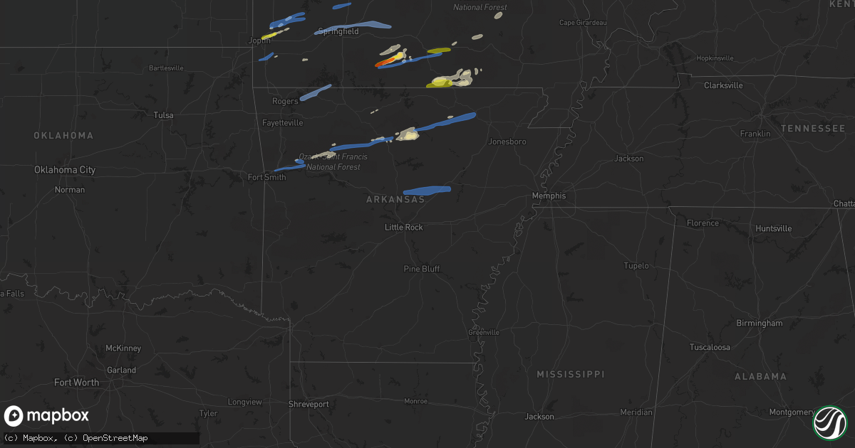
Hail Map in Arkansas on November 14, 2020
Get this storm
November 14 map
$229
one time, instant access
Download today. No call, no setup
Keep the $229
Bought the map and want the full workflow? Apply the entire $229 to a subscription within 7 days. None of it is wasted.
Every map, not just this one
This buys you this map. Subscription and you get every map we run, in the markets you choose from a few cities to whole states to nationwide. Plus real-time alerts the moment a storm fires.
Contact data
Name, contact info, occupancy, even credit band for addresses in the footprint. You go from where it hit to who to call.
Become the source they trust
Unlimited branding weather history reports on demand. You already have the documented answer ready for the property owner, and you are the one who showed up with it.
Property data and RoofTrace estimates
Pull up any address you have got, its value and the exact code rules for that jurisdiction, straight from One Click Code. Then RoofTrace estimates the squares, pitch, and roof value, priced the way you price.
Storm reports in Arkansas
Arkansas
| Date | Description |
|---|---|
| 11/14/20205:57 AM CST | At 1157 PM CST, a severe thunderstorm was located near Thola, or 14 miles west of Mountain View, moving east at 50 mph. HAZARD...60 mph wind gusts and nickel size hail. SOURCE...Radar indicated. IMPACT...Expect damage to roofs, siding, and trees. Locations impacted include... Mountain View... Melbourne... Cushman... Mount Pleasant... Thola... Brandenberg... Croker... Lone Star... Gid... Herpel... Elba... Stella... Lunenburg... Elberta... Blanchard Springs Campground... Bethesda... Guion... Allison... Alco... Hanover... |
| 11/14/20205:32 AM CST | At 1132 PM CST, a severe thunderstorm was located over Brandenberg, or 8 miles southwest of Melbourne, moving east at 45 mph. HAZARD...60 mph wind gusts and penny size hail. SOURCE...Radar indicated. IMPACT...Expect damage to roofs, siding, and trees. Locations impacted include... Melbourne... Cave City... Mount Pleasant... Sidney... Brandenberg... Lone Star... Gid... Stella... Lunenburg... Lacrosse... Evening Shade... Guion... Aetna... Mt Olive in Izard County... Zion... Calamine... Nelsonville... Maxville... Center... Boswell... |
| 11/14/20205:30 AM CST | At 1130 PM CST, severe thunderstorms were located along a line extending from near Midway in Logan County to 6 miles southeast of Mount Magazine to 7 miles northeast of Cardiff, moving east at 70 mph. HAZARD...60 mph wind gusts and penny size hail. SOURCE...Radar indicated. IMPACT...Expect damage to roofs, siding, and trees. Locations impacted include... Russellville... Clarksville... Morrilton... Clinton... Danville... Dardanelle... Atkins... Pottsville... Lamar... Dover... Ola... London... Knoxville... Hector... Scranton... Blue Mountain... Lake Dardanelle State Park... Happy Bend... Hattieville... Jerusalem...This includes Interstate 40 between mile markers 58 and 106. |
| 11/14/20205:27 AM CST | At 1126 PM CST, severe thunderstorms were located along a line extending from near Witts Spring to near Moore to near Bertha to near Holman, moving east at 65 mph. HAZARD...60 mph wind gusts and penny size hail. SOURCE...Radar indicated. IMPACT...Expect damage to roofs, siding, and trees. Locations impacted include... Clarksville... Clinton... Marshall... Lamar... Shirley... Marsena... Witts Spring... Rocky Hill... Moore... Dabney... Bohannon... Imo... Elberta... Watts... Holman... Thola... Kay... Dillen... Solo... Smyrna...This includes Interstate 40 near mile marker 58. |
| 11/14/20205:23 AM CST | At 1123 PM CST, severe thunderstorms were located along a line extending from 9 miles southeast of Alton to 10 miles east of Mammoth Spring, moving east at 65 mph. HAZARD...70 mph wind gusts and ping pong ball size hail. SOURCE...Radar indicated. IMPACT...People and animals outdoors will be injured. Expect hail damage to roofs, siding, windows, and vehicles. Expect considerable tree damage. Wind damage is also likely to mobile homes, roofs, and outbuildings. Locations impacted include... Mammoth Spring... Mammoth Spring State Park... Myrtle... |
| 11/14/20205:02 AM CST | At 1102 PM CST, severe thunderstorms were located along a line extending from near Echo to near Morgan Springs, moving east at 55 mph. HAZARD...60 mph wind gusts. SOURCE...Radar indicated. IMPACT...Expect damage to roofs, siding, and trees. Locations impacted include... Booneville... Waldron... Mansfield... Magazine... Blue Mountain... Beauchamp... Stonehouse Recreation Area... Cardiff... Mount Magazine... Echo... Oliver... Morgan Springs... Havana... Bates... Barber... Black Fork... Winfield... Olio... Chismville... Liberty... |
| 11/14/20204:58 AM CST | At 1057 PM CST, severe thunderstorms were located along a line extending from 7 miles southeast of Lost Valley State Park to 6 miles southwest of Devils Knob to near Wiederkehr Village to 6 miles north of Branch, moving east at 45 mph. HAZARD...60 mph wind gusts and penny size hail. SOURCE...Radar indicated. IMPACT...Expect damage to roofs, siding, and trees. Locations impacted include... Clarksville... Paris... Jasper... Lamar... Knoxville... Subiaco... Hartman... Western Grove... Scranton... Ratcliff... Carver... Erbie... Moore... Upper Buffalo Wilderness Area... Point Peter... Devils Knob... Hoyt... Lost Valley State Park... Midway in Logan County... Pruitt...This includes Interstate 40 between mile markers 44 and 67. |
| 11/14/20204:57 AM CST | At 1057 PM CST, severe thunderstorms were located along a line extending from 9 miles southeast of Cass to 4 miles north of Charleston to 2 miles southeast of Hackett, moving southeast at 25 mph. Winds gusted to 61 mph in Fort Smith. HAZARD...60 mph wind gusts. SOURCE...Radar indicated. IMPACT...Expect damage to roofs, siding, and trees. Locations in or near the path include... Fort Smith... Ozark... Charleston... Greenwood... Barling... Lavaca... Mulberry... Dyer... Hackett... Altus... Hartford... Huntington... Bonanza... Branch... Midland... Denning... Wiederkehr Village... Bloomer... Burnville... Jenny Lind...This includes the following highways, Interstate 40 in Arkansas between mile markers 23 and 42. Interstate 540 between mile markers 9 and 14. |
| 11/14/20204:44 AM CST | At 1044 PM CST, a severe thunderstorm was located near Marsena, or 7 miles southwest of Marshall, moving east at 50 mph. HAZARD...60 mph wind gusts and penny size hail. SOURCE...Radar indicated. IMPACT...Expect damage to roofs, siding, and trees. Locations impacted include... Mountain View... Marshall... Calico Rock... Thola... Kay... Brandenberg... Gorby... Herpel... Elberta... Watts... Blanchard Springs Campground... Leslie... Big Flat... Gilbert... Allison... Zach... Alco... Canaan... Mt Olive in Izard County... Morning Star... |
| 11/14/20204:34 AM CST | At 1034 PM CST, a severe thunderstorm was located near Yellville, moving east at 50 mph. HAZARD...60 mph wind gusts and nickel size hail. SOURCE...Radar indicated. IMPACT...Expect damage to roofs, siding, and trees. Locations impacted include... Mountain Home... Yellville... Gassville... Flippin... Norfork... Salesville... Briarcliff... Norfork Dam... Diamond Bay... Gamaliel Landing... Shipp... Herron... Colfax... Rush... Lion Hill... Rodney... Advance... Cartney... Cotter... Summit... |
| 11/14/20204:11 AM CST | At 1010 PM CST, severe thunderstorms were located along a line extending from near Walnut to 7 miles southeast of Cass, moving east at 45 mph. HAZARD...60 mph wind gusts and quarter size hail. SOURCE...Radar indicated. IMPACT...Hail damage to vehicles is expected. Expect wind damage to roofs, siding, and trees. Locations impacted include... Marshall... Marsena... Kay... Witts Spring... Dillen... Duff... Moore... Point Peter... Eula... Bohannon... Imo... Bertha... Watts... Gilbert... Ben Hur... Zach... Bass... Canaan... Silver Hill... Fort Douglas... |
| 11/14/20203:50 AM CST | At 950 PM CST, a severe thunderstorm was located 4 miles south of Cass, moving east at 50 mph. HAZARD...60 mph wind gusts and nickel size hail. SOURCE...Radar indicated. IMPACT...Expect damage to roofs, siding, and trees. Locations in or near the path include... Ozark... Cass... Jethro... Barnes... Redding... Turners Bend... Watalula... Taft... Paradise... This includes Interstate 40 in Arkansas between mile markers 33 and34. |
| 11/14/20203:49 AM CST | At 948 PM CST, a severe thunderstorm was located near Cass, or 8 miles north of Ozark, moving northeast at 45 mph. HAZARD...60 mph wind gusts and quarter size hail. SOURCE...Radar indicated. IMPACT...Hail damage to vehicles is expected. Expect wind damage to roofs, siding, and trees. Locations impacted include... Walnut... Rosetta... Devils Knob... Oak Grove in Johnson County... Salus... Catalpa... Fort Douglas... Friley... Yale... Ozone... Fallsville... Swain... Haw Creek Falls Campground... Oark... Dixon Ridge... Nail... Wolf Pen Campground... Arbaugh... Mineral Springs Recreation Area... |
| 11/14/20202:30 AM CST | Pavillion roof blown off... Flag pole downed |
| 11/14/20202:15 AM CST | Highway 270 5 miles east of sheridan was blocked by downed live power lines per arkansas state police. |
| 11/14/20201:15 AM CST | *** 4 inj *** the nws survey revealed an ef1 tornado. The tornado started just west of wayne walker road... Rolling a mobile home. Another mobile home was severely dama |
| 11/14/20201:10 AM CST | Reports of homes moved... Trees down... People trapped with injuries near wayne walker road... Highland circle... And rg davis road in romance... Ar. |
| 11/14/20201:10 AM CST | Wind gusts knocked over train cars. Train was stopped when the line of storms moved through hoxie... Ar. These were empty grain cars. 15 cars blew over on their sides.. |
| 11/14/20201:10 AM CST | Power lines and poles down across lawrence county road 701 per lawrence county sheriff's department. |
| 11/14/20201:10 AM CST | *** 4 inj *** ef1 damage found...survey is ongoing. |
| 11/14/202012:10 AM CST | One tree and a couple of road signs were blown down. |
| 11/13/202010:50 PM CST | Numerous trees down near the intersection of wire road and white valley road. Report from the 911 center and relayed by emergency management. |
| 11/13/202010:42 PM CST | A local report indicates 61 MPH wind near FORT SMITH REGIONAL AIR |
| 11/13/202010:35 PM CST | A local report indicates 60 MPH wind near MOUNTAIN HOME |
| 11/13/202010:30 PM CST | Numerous 8 to 10 inch diameter tree limbs broken. Public photos sent to local media. |
| 11/13/20209:57 PM CST | Picture on social media shows a large tree down in lowell. Time is estimated from radar. |
| 11/13/20209:25 PM CST | Signifcant roof damage to an auto shop and a church. Time estimated from radar. |
Cities Impacted by Hail Map on November 14, 2020
- Dora, MO
- Clinton, MO
- Montrose, MO
- Butler, MO
- Urich, MO
- Evening Shade, AR
- Koshkonong, MO
- West Plains, MO
- Myrtle, MO
- Couch, MO
- Alton, MO
- Thayer, MO
- Adrian, MO
- Carthage, MO
- Ava, MO
- Drury, MO
- Holden, MO
- Winona, MO
- Ellington, MO
- Leslie, AR
- Marshall, AR
- Monett, MO
- Verona, MO
- Creighton, MO
- Fox, AR
- Timbo, AR
- Granby, MO
- Mulberry, AR
- Ozark, AR
- Reeds, MO
- Sarcoxie, MO
- Clarksville, AR
- Ozone, AR
- Squires, MO
- Norwood, MO
- Vanzant, MO
- Hardy, AR
- Deer, AR
- Eminence, MO
- Mountain View, AR
- Oark, AR
- Hagarville, AR
- Yellville, AR
- Lesterville, MO
- Malden, MO
- Campbell, MO
- Centerview, MO
- Lebanon, MO
- Blairstown, MO
- Rector, AR
- Marmaduke, AR
- Fifty Six, AR
- Lockwood, MO
- Golden City, MO
- Stoutland, MO
- Richland, MO
- Waynesville, MO
- Laquey, MO
- Jasper, MO
- Noble, MO
- Wasola, MO
- Kennett, MO
- Holcomb, MO
- Avilla, MO
- Joplin, MO
- Doniphan, MO
- Onia, AR
- Annapolis, MO
- Redford, MO
- Birch Tree, MO
- Brandsville, MO
- Melbourne, AR
- Webb City, MO
- Carterville, MO
- Thornfield, MO
- Pomona, MO
- Mountain View, MO
- Willow Springs, MO
- South Greenfield, MO
- Greenfield, MO
- Lamar, MO
- Knob Noster, MO
- Warrensburg, MO
- Buffalo, MO
- Pleasant Hope, MO
- Bolivar, MO
- Morrisville, MO
- Elkland, MO
- Half Way, MO
- Brighton, MO
- Neosho, MO
- Calhoun, MO
- Brumley, MO
- Macks Creek, MO
- Linn Creek, MO
- Camdenton, MO
- Roach, MO
- Montreal, MO
- Devils Elbow, MO
- Steelville, MO
- Saint Robert, MO
- Fort Leonard Wood, MO
- Newburg, MO
- Cuba, MO
- Dixon, MO
- Duke, MO
- Leasburg, MO
- Rolla, MO
- Saint James, MO
- Jerome, MO
- Marshfield, MO
- Strafford, MO
- Niangua, MO
- Mansfield, MO
- Rogersville, MO
- Ash Grove, MO
- Seymour, MO
- Hartville, MO
- Springfield, MO
- Bois D Arc, MO
- Marionville, MO
- Republic, MO
- Blue Eye, MO
- Berryville, AR
- Eureka Springs, AR
- Lampe, MO
- Rogers, AR
- Brixey, MO
- Mount Judea, AR
- Witts Springs, AR
- Van Buren, AR
- Dyer, AR
- Alma, AR
- Ravenden, AR
- Sidney, AR
- Poughkeepsie, AR
- Smithville, AR
- Horseshoe Bend, AR
- Guion, AR
- Black Rock, AR
- Sage, AR
- Mount Pleasant, AR
- Imboden, AR
- McRae, AR
- Searcy, AR
- Greenbrier, AR
- Beebe, AR
- Judsonia, AR
- Mount Vernon, AR
- Kensett, AR
- Enola, AR
- El Paso, AR
- Higginson, AR
- Vilonia, AR
- Romance, AR


