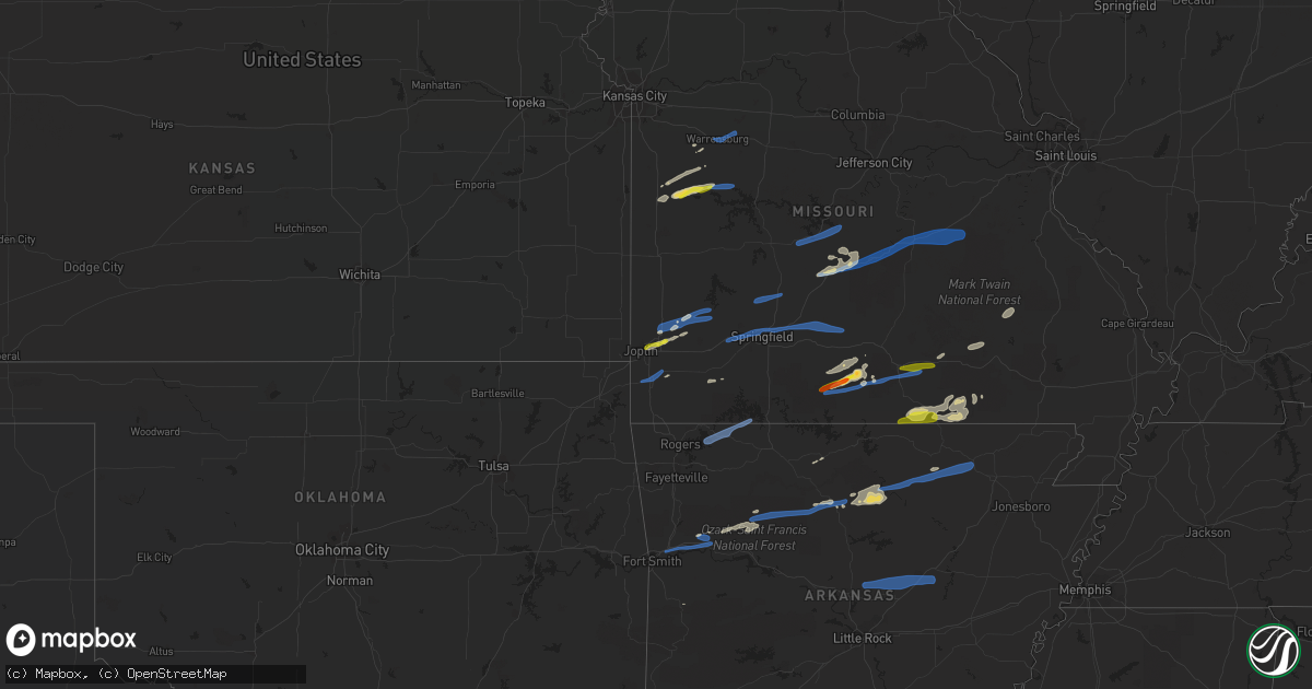
Hail Map on November 14, 2020
Get this storm
November 14 map
$229
one time, instant access
Download today. No call, no setup
Keep the $229
Bought the map and want the full workflow? Apply the entire $229 to a subscription within 7 days. None of it is wasted.
Every map, not just this one
This buys you this map. Subscription and you get every map we run, in the markets you choose from a few cities to whole states to nationwide. Plus real-time alerts the moment a storm fires.
Contact data
Name, contact info, occupancy, even credit band for addresses in the footprint. You go from where it hit to who to call.
Become the source they trust
Unlimited branding weather history reports on demand. You already have the documented answer ready for the property owner, and you are the one who showed up with it.
Property data and RoofTrace estimates
Pull up any address you have got, its value and the exact code rules for that jurisdiction, straight from One Click Code. Then RoofTrace estimates the squares, pitch, and roof value, priced the way you price.
Storm reports
Ohio
| Date | Description |
|---|---|
| 11/13/202010:59 PM CST | Tree down along garrett ridge road |
Oklahoma
| Date | Description |
|---|---|
| 11/14/20203:59 AM CST | At 958 PM CST, severe thunderstorms were located along a line extending from 6 miles east of Bunch to 2 miles east of Briartown, moving southeast at 35 mph. HAZARD...60 mph wind gusts. SOURCE...Radar indicated. IMPACT...Expect damage to roofs, siding, and trees. Locations in or near the path include... Sallisaw... Stigler... Muldrow... Vian... Keota... Mccurtain... Whitefield... Gans... Marble City... Tamaha... Brushy... Briartown... Mc Curtain... Brushy Lake State Park... Short... Kanima... Mc Key... This includes Interstate 40 in Oklahoma between mile markers 295 and317. |
| 11/14/20203:49 AM CST | At 948 PM CST, severe thunderstorms were located along a line extending from 4 miles southeast of Gateway to 5 miles southwest of Maryetta, moving southeast at 35 mph. HAZARD...60 mph wind gusts. SOURCE...Radar indicated. IMPACT...Expect damage to roofs, siding, and trees. Locations in or near the path include... Fayetteville... Springdale... Rogers... Bentonville... Berryville... Stilwell... Eureka Springs... Cedarville... Natural Dam... Lowell... Farmington... Prairie Grove... Elkins... Tontitown... Bethel Heights... West Fork... Lincoln... Cave Springs... Westville... Greenland...This includes Interstate 49 between mile markers 40 and 87. |
| 11/14/202012:04 AM CST | At 604 PM CST, severe thunderstorms were located along a line extending from 7 miles north of Bolivar to near Lockwood, moving northeast at 50 mph. HAZARD...60 mph wind gusts and quarter size hail. SOURCE...Radar indicated. IMPACT...Hail damage to vehicles is expected. Expect wind damage to roofs, siding, and trees. Locations impacted include... Southeastern Joplin... Carthage... Neosho... Bolivar... Stockton Lake... Seneca... Granby... Duquesne... Greenfield... Sarcoxie... Duenweg... Lockwood... Diamond... Loma Linda... Miller... Leawood... Silver Creek... Shoal Creek Drive... Everton... Saginaw...This includes the following highways... Interstate 44 between mile markers 4 and 5, and between mile markers7 and 36. Interstate 49 between mile markers 16 and 41. |
| 11/13/202011:31 PM CST | At 530 PM CST, a severe thunderstorm was located over Oronogo, or 8 miles north of Joplin, moving northeast at 45 mph. HAZARD...60 mph wind gusts and quarter size hail. SOURCE...Radar indicated. IMPACT...Hail damage to vehicles is expected. Expect wind damage to roofs, siding, and trees. Locations impacted include... Joplin... Carthage... Webb City... Stockton Lake... Carl Junction... Baxter Springs... Galena... Oronogo... Carterville... Duquesne... Greenfield... Duenweg... Lockwood... Jasper... Golden City... Loma Linda... Airport Drive... Leawood... Lowell... Silver Creek...This includes the following highways... Interstate 44 between mile markers 0 and 15. Interstate 49 near mile marker 35, and between mile markers 38 and60. |
| 11/13/20209:50 PM CST | Measured at the cookson mesonet site. |
| 11/13/20206:18 PM CST | Delayed report... Em reports structure damage to an outbuilding and a barn near cayuga rd and e 152 rd. Time estimated from radar. |
Missouri
| Date | Description |
|---|---|
| 11/14/20205:55 PM CST | Trees down including large trees over mainly central and eastern jasper county. Time estimated from radar. |
| 11/14/20205:27 AM CST | At 1126 PM CST, a severe thunderstorm was located near Handy, or 19 miles west of Doniphan, moving northeast at 75 mph. HAZARD...70 mph wind gusts and quarter size hail. SOURCE...Radar indicated. IMPACT...Hail damage to vehicles is expected. Expect considerable tree damage. Wind damage is also likely to mobile homes, roofs, and outbuildings. Locations impacted include... Ellsinore, Budapest, Hunter, Handy, Gatewood, Grandin and Briar. |
| 11/14/20204:48 AM CST | At 1047 PM CST, severe thunderstorms were located along a line extending from near Ott to near Diamond Bay, moving east at 45 mph. HAZARD...60 mph wind gusts and nickel size hail. SOURCE...Radar indicated. IMPACT...Expect damage to roofs, siding, and trees. Locations impacted include... Cherokee Village... Salem in Fulton County... Mammoth Spring... Oxford... Viola... Bexar... Flint Springs... Sturkie... Byron... Rodney... Agnos... Heart... Moko... Fryatt... Union... Kittle... Saddle... Salem Airport... Mitchell... Wild Cherry... |
| 11/14/20204:37 AM CST | At 1037 PM CST, a severe thunderstorm was located near Ott, or 15 miles northeast of Mountain Home, moving east at 55 mph. HAZARD...70 mph wind gusts and ping pong ball size hail. SOURCE...Radar indicated. IMPACT...People and animals outdoors will be injured. Expect hail damage to roofs, siding, windows, and vehicles. Expect considerable tree damage. Wind damage is also likely to mobile homes, roofs, and outbuildings. Locations impacted include... Grand Gulf State Park... Thayer... Alton... Koshkonong... Brandsville... Lanton... Rover... Moody... Wilderness... Couch... Greer... |
| 11/14/20204:32 AM CST | At 1032 PM CST, severe thunderstorms were located along a line extending from Bunker to 11 miles southwest of Reynolds to near Birch Tree to 6 miles southeast of Mountain View, moving east at 40 mph. HAZARD...70 mph wind gusts and quarter size hail. SOURCE...Radar indicated. IMPACT...Hail damage to vehicles is expected. Expect considerable tree damage. Wind damage is also likely to mobile homes, roofs, and outbuildings. Locations impacted include... Winona... Birch Tree... Eminence... Montier... Alley Spring... Teresita... Midridge... West Eminence... |
| 11/14/20204:11 AM CST | At 1009 PM CST, severe thunderstorms were located along a line extending from near Urbanette to near Devils Den State Park to 5 miles northwest of Mccurtain, moving southeast at 45 mph. HAZARD...60 mph wind gusts. SOURCE...Radar indicated. IMPACT...Expect damage to roofs, siding, and trees. Locations in or near the path include... Fort Smith... Fayetteville... Van Buren... Sallisaw... Poteau... Berryville... Ozark... Charleston... Huntsville... Cedarville... Mountainburg... Natural Dam... Greenwood... Alma... Barling... Pocola... Muldrow... Roland... Green Forest... Elkins...This includes the following highways, Interstate 40 in Arkansas between mile markers 0 and 38. Interstate 40 in Oklahoma between mile markers 306 and 328. Interstate 540 between mile markers 1 and 14. Interstate 49 between mile markers 22 and 53. |
| 11/14/20203:58 AM CST | At 958 PM CST, severe thunderstorms were located along a line extending from 6 miles northwest of Summersville to 12 miles northwest of West Plains to 8 miles northwest of Gainesville, moving east at 55 mph. HAZARD...60 mph wind gusts and quarter size hail. SOURCE...Radar indicated. IMPACT...Hail damage to vehicles is expected. Expect wind damage to roofs, siding, and trees. Locations impacted include... West Plains... Mountain View... Willow Springs... Pomona... Summersville... Brandsville... Montier... Peace Valley... Teresita... Brixey... Arroll... Pottersville... Eunice... Siloam Springs... White Church... Hartshorn... Sycamore... Clear Springs... Dora... Pine Crest... |
| 11/14/20203:38 AM CST | At 938 PM CST, a severe thunderstorm was located 8 miles north of Bunker, moving east at 55 mph. HAZARD...60 mph wind gusts and quarter size hail. SOURCE...Radar indicated. IMPACT...Hail damage to vehicles is expected. Expect wind damage to roofs, siding, and trees. Locations impacted include... Ironton, Pilot Knob, Viburnum, Arcadia, Irondale, Bunker, Courtois, Belleview, Oates, Bixby, Roselle, Caledonia, Belgrade, Hogan, Black and Granite.This also includes Johnsons Shut-Ins State Park, Fort DavidsonHistoric Site, Elephant Rocks State Park, and Taum Sauk MountainState Park. |
| 11/14/20203:16 AM CST | At 916 PM CST, a severe thunderstorm was located over Hollister, or near Branson, moving northeast at 55 mph. HAZARD...60 mph wind gusts and quarter size hail. SOURCE...Radar indicated. IMPACT...Hail damage to vehicles is expected. Expect wind damage to roofs, siding, and trees. Locations impacted include... Branson... Lake Taneycomo... Table Rock Lake... Bull Shoals Lake... Table Rock State Park... Hollister... Silver Dollar City... Kimberling City... Forsyth... Merriam Woods... Kissee Mills... Rockaway Beach... Bull Creek... Indian Point... Branson West... Taneyville... Table Rock... Kirbyville... Blue Eye... Coney Island... |
| 11/14/20202:58 AM CST | At 858 PM CST, severe thunderstorms were located along a line extending from near Houston to near Mountain Grove, moving east at 50 mph. HAZARD...60 mph wind gusts and quarter size hail. SOURCE...Radar indicated. IMPACT...Hail damage to vehicles is expected. Expect wind damage to roofs, siding, and trees. Locations impacted include... Current River State Park... Echo Bluff State Park... Cabool... Houston... Eminence... Summersville... Midridge... Arroll... Elk Creek... Eunice... Alley Spring... Yukon... Hartshorn... Clear Springs... Round Spring... West Eminence... Solo... Pine Crest... Simmons... Bendavis... |
| 11/14/20202:43 AM CST | At 843 PM CST, a severe thunderstorm was located 3 miles southeast of Garfield, moving east at 50 mph. HAZARD...60 mph wind gusts and quarter size hail. SOURCE...Radar indicated. IMPACT...Hail damage to vehicles is expected. Expect wind damage to roofs, siding, and trees. Locations in or near the path include... Eureka Springs... Gateway... Beaver... Urbanette... Grandview... Pleasant Ridge... Hill Top... Walnut Hill... Oak Hill... Busch... |
| 11/14/20202:38 AM CST | At 837 PM CST, a severe thunderstorm was located near St. James, moving east at 60 mph. HAZARD...60 mph wind gusts. SOURCE...Radar indicated. IMPACT...Expect damage to roofs, siding, and trees. Locations impacted include... Sullivan, St. Clair, Cuba, Potosi, Steelville, Bourbon, Anthonies Mill, Parkway, Mineral Point, Leasburg, Miramiguoa Park, Richwoods, Old Mines, Lonedell, Cherryville, St. Cloud, Japan, Stanton, Cadet and Latty.This includes Interstate 44 in Missouri between exits 203 and 230. This also includes Washington State Park, Onondaga Cave State Park,and Meramec State Park. |
| 11/14/20202:38 AM CST | At 838 PM CST, severe thunderstorms were located along a line extending from 8 miles south of Fort Leonard Wood to 18 miles west of Licking to 15 miles west of Houston, moving east at 120 mph. HAZARD...70 mph wind gusts and quarter size hail. SOURCE...Radar indicated. IMPACT...Hail damage to vehicles is expected. Expect considerable tree damage. Wind damage is also likely to mobile homes, roofs, and outbuildings. Locations impacted include... Southern Fort Leonard Wood... Montauk State Park... Ozark National Scenic Riverways... Licking... Houston... Bunker... Raymondville... Huggins... Plato... Montauk... Turtle... Jadwin... Beulah... Darien... Bucyrus... Hazelton... Gladden... Success... Roby... Akers... |
| 11/14/20202:22 AM CST | At 822 PM CST, a severe thunderstorm was located over Grandview, or near Berryville, moving northeast at 55 mph. HAZARD...60 mph wind gusts and half dollar size hail. SOURCE...Radar indicated. IMPACT...Hail damage to vehicles is expected. Expect wind damage to roofs, siding, and trees. Locations impacted include... Branson... Lake Taneycomo... Table Rock Lake... Bull Shoals Lake... Table Rock State Park... Hollister... Silver Dollar City... Kimberling City... Forsyth... Merriam Woods... Shell Knob... Kissee Mills... Rockaway Beach... Bull Creek... Indian Point... Branson West... Taneyville... Golden... Table Rock... Emerald Beach... |
| 11/14/20202:08 AM CST | At 807 PM CST, severe thunderstorms were located along a line extending from near Bland to Fort Leonard Wood, moving east at 75 mph. HAZARD...60 mph wind gusts and quarter size hail. SOURCE...Radar indicated. IMPACT...Hail damage to vehicles is expected. Expect wind damage to roofs, siding, and trees. Locations impacted include... Rolla... Fort Leonard Wood... Salem... St. Robert... St. James... Doolittle... Newburg... Edgar Springs... Lenox... Beulah... Howes Mill... Devil's Elbow... Vichy... Lake Spring... Anutt... Bangert... Boss... Howes... Northwye... Lecoma...This includes Interstate 44 between mile markers 164 and 169, andbetween mile markers 171 and 200. |
| 11/14/20202:06 AM CST | At 805 PM CST, severe thunderstorms were located along a line extending from near Niangua to near Rogersville to near Highlandville, moving east at 60 mph. HAZARD...60 mph wind gusts and quarter size hail. SOURCE...Radar indicated. IMPACT...Hail damage to vehicles is expected. Expect wind damage to roofs, siding, and trees. Locations impacted include... Mountain Grove... Ava... Seymour... Sparta... Mansfield... Fordland... Dawson... Norwood... Hartville... Duncan... Diggins... Competition... Oldfield... Manes... Brushyknob... Elkhead... Lynchburg... Grovespring... Chadwick... Bruner... |
| 11/14/20201:59 AM CST | At 758 PM CST, a severe thunderstorm was located 7 miles west of Eureka Springs, moving east at 55 mph. HAZARD...60 mph wind gusts and penny size hail. SOURCE...Radar indicated. IMPACT...Expect damage to roofs, siding, and trees. Locations in or near the path include... Berryville... Eureka Springs... Beaver... Urbanette... Grandview... Larue... Pleasant Ridge... Beaver Lake... Oak Hill... Busch... |
| 11/14/20201:51 AM CST | At 751 PM CST, severe thunderstorms were located along a line extending from 6 miles northwest of Cole Camp to near Lincoln to near Warsaw, moving east at 55 mph. HAZARD...60 mph wind gusts. SOURCE...Radar indicated. IMPACT...Expect damage to roofs, siding, and trees. Locations impacted include... Lincoln... Cole Camp... Ionia... Crockerville... Edmonson... Mora... |
| 11/14/20201:33 AM CST | At 733 PM CST, severe thunderstorms were located along a line extending from 8 miles west of Freeburg to near Lebanon to 6 miles northeast of Fair Grove, moving northeast at 45 mph. HAZARD...60 mph wind gusts and quarter size hail. SOURCE...Radar indicated. IMPACT...Hail damage to vehicles is expected. Expect wind damage to roofs, siding, and trees. Locations impacted include... Northwestern Fort Leonard Wood... Lebanon... Marshfield... Waynesville... St. Robert... Rogersville... Richland... Dixon... Belle... Morgan... Crocker... Fordland... Conway... Vienna... Niangua... Phillipsburg... Stoutland... Twin Bridges... Elkland... Grovespring...This includes Interstate 44 between mile markers 91 and 132, betweenmile markers 136 and 169, and between mile markers 171 and 176. |
| 11/14/20201:23 AM CST | At 723 PM CST, severe thunderstorms were located along a line extending from near Republic to near Purdy, moving east at 60 mph. HAZARD...60 mph wind gusts and quarter size hail. SOURCE...Radar indicated. IMPACT...Hail damage to vehicles is expected. Expect wind damage to roofs, siding, and trees. Locations impacted include... Springfield... Nixa... Ozark... Republic... Aurora... Battlefield... Willard... Strafford... Marionville... Clever... Sparta... Crane... Fair Grove... Billings... Highlandville... Fremont Hills... Verona... Galena... Brookline... Hurley...This includes Interstate 44 between mile markers 63 and 89. |
| 11/14/20201:11 AM CST | At 711 PM CST, a severe thunderstorm was located near Montrose, or 14 miles west of Clinton, moving east at 70 mph. HAZARD...60 mph wind gusts and quarter size hail. SOURCE...Radar indicated. IMPACT...Hail damage to vehicles is expected. Expect wind damage to roofs, siding, and trees. Locations impacted include... Sedalia, Clinton, Windsor, Leeton, Urich, Green Ridge, Calhoun, Montrose, Chilhowee, Coal, Blairstown, Tightwad, Ballard, Post Oak, Hartwell, La Due and Truman Lake. |
| 11/14/202012:49 AM CST | At 649 PM CST, a severe thunderstorm was located over Everton, or 11 miles southeast of Greenfield, moving east at 60 mph. HAZARD...60 mph wind gusts and quarter size hail. SOURCE...Radar indicated. IMPACT...Hail damage to vehicles is expected. Expect wind damage to roofs, siding, and trees. Locations impacted include... Northwestern Springfield... Monett... Willard... Mount Vernon... Ash Grove... Fair Grove... Pierce City... Miller... Walnut Grove... Everton... Brookline... Stotts City... Halltown... Freistatt... Hoberg... Chesapeake... Sacville... Glidewell... Ebenezer... Bassville...This includes Interstate 44 between mile markers 37 and 68, andbetween mile markers 70 and 76. |
| 11/14/202012:48 AM CST | At 648 PM CST, a severe thunderstorm was located over Lanagan, or near Pineville, moving east at 45 mph. HAZARD...60 mph wind gusts and half dollar size hail. SOURCE...Radar indicated. IMPACT...Hail damage to vehicles is expected. Expect wind damage to roofs, siding, and trees. Locations impacted include... Neosho... Big Sugar Creek State Park... Monett... Cassville... Anderson... Noel... Goodman... Purdy... South West City... Seligman... Pineville... Exeter... Wheaton... Butterfield... Washburn... Lanagan... Fairview... Newtonia... Pioneer... Stella...This includes Interstate 49 between mile markers 1 and 16. |
| 11/14/202012:45 AM CST | At 645 PM CST, severe thunderstorms were located along a line extending from near Camdenton to near Pleasant Hope, moving east at 40 mph. HAZARD...60 mph wind gusts and quarter size hail. SOURCE...Radar indicated. IMPACT...Hail damage to vehicles is expected. Expect wind damage to roofs, siding, and trees. Locations impacted include... Lebanon... Lake of The Ozarks... Lake of The Ozarks State Park... Ha Ha Tonka State Park... Bennett Spring State Park... Osage Beach... Camdenton... Buffalo... Village of Four Seasons... Richland... Lake Ozark... Morgan... Conway... Iberia... Pleasant Hope... Sunrise Beach... Niangua... Morrisville... Macks Creek... Linn Creek...This includes Interstate 44 between mile markers 102 and 143. |
| 11/14/202012:30 AM CST | At 630 PM CST, a severe thunderstorm was located near Hermitage, moving northeast at 45 mph. HAZARD...60 mph wind gusts and quarter size hail. SOURCE...Radar indicated. IMPACT...Hail damage to vehicles is expected. Expect wind damage to roofs, siding, and trees. Locations impacted include... Pomme de Terre Lake... Stockton Lake... Pomme De Terre State Park... Pittsburg... Polk... Fair Play... Preston... Nemo... |
| 11/14/202012:12 AM CST | At 612 PM CST, severe thunderstorms were located along a line extending from 6 miles west of Warrensburg to near Holden to near Garden City, moving east at 50 mph. HAZARD...60 mph wind gusts. SOURCE...Radar indicated. IMPACT...Expect damage to roofs, siding, and trees. Locations impacted include... Warrensburg, Knob Noster, Holden, Whiteman Air Force Base, La Monte, Houstonia, Whiteman Afb, Centerview and Hughesville. |
| 11/13/202011:54 PM CST | At 554 PM CST, a severe thunderstorm was located near Stockton, moving northeast at 45 mph. HAZARD...60 mph wind gusts and quarter size hail. SOURCE...Radar indicated. IMPACT...Hail damage to vehicles is expected. Expect wind damage to roofs, siding, and trees. Locations impacted include... Stockton Lake... Pomme de Terre Lake... Pomme De Terre State Park... Stockton State Park... Stockton... Pittsburg... Humansville... Polk... Fair Play... Hermitage... Wheatland... Preston... Cross Timbers... Flemington... Umber View Heights... Bearcreek... Masters... Cane Hill... Elkton... Arnica... |
| 11/13/20209:46 PM CST | A local report indicates 1.75 inch wind near GENTRYVILLE |
| 11/13/20209:45 PM CST | Large tree blown over onto highway y on north side of viburnum. |
| 11/13/20209:38 PM CST | Trees down on highway 95 in the drury area. |
| 11/13/20209:34 PM CST | Trees down on highway 95 near drury. Time from radar. |
| 11/13/20209:15 PM CST | Large tree down. Time estimated from radar. |
| 11/13/20209:05 PM CST | Large tree blown over onto highway w. |
| 11/13/20209:01 PM CST | Power lines down near joe bald. Time estimated by radar. |
| 11/13/20209:00 PM CST | Trees down on road just north of baxter marina. |
| 11/13/20208:50 PM CST | Large tree blown over onto saranac springs road. |
| 11/13/20208:42 PM CST | Picture via social media of multiple large tree branches broken. Time estimated from radar. |
| 11/13/20208:14 PM CST | Time estimated from radar. |
| 11/13/20208:10 PM CST | Delayed report. Trees down across the road on teagues road just south of the intersection with moonlight road. Time estimated from radar. |
| 11/13/20208:02 PM CST | A few mobile homes heavily damaged or destroyed. Camper blown on its side. Multiple trees uprooted. Large sections of fencing blown over. |
| 11/13/20208:02 PM CST | Possible tornado. Damage reports coming in from areas north of saint roberts to dixon. Reports of structures damaged and destroyed with rescue operations underway. Time |
| 11/13/20207:58 PM CST | Mping report of quarter sized hail. Time estimated from radar. |
| 11/13/20207:55 PM CST | Power line down in cole camp. Time estimated by radar. |
| 11/13/20207:46 PM CST | Tree on house and damage to a couple of barns. |
| 11/13/20207:46 PM CST | 3 power poles down on glenstone near primrose. Time estimated from radar. |
| 11/13/20207:38 PM CST | Ksgf asos. |
| 11/13/20207:36 PM CST | 12 inch diameter tree branch broken off at the nws office. Time estimated from radar and nearby timing of maximum wind gusts at the sgf asos. |
| 11/13/20207:23 PM CST | A local report indicates 1.00 inch wind near 2 NW CLINTON |
| 11/13/20207:12 PM CST | Report relayed via social media. Time estimated via radar. |
| 11/13/20207:10 PM CST | Pictures via social media of multiple large trees down. Also damage to a carport... Steel roofing material peeled back on an outbuilding... And partial collapse of a wa |
| 11/13/20207:01 PM CST | Estimated 50 to 60 mph winds. |
| 11/13/20206:58 PM CST | Adds to previous tstm wnd dmg report from 1 wsw osage beach. Significant roof damage to strip mall. Collaboration between the national weather service and emergency man |
| 11/13/20206:46 PM CST | Measure 61 mph winds. Power outages in central neosho. |
| 11/13/20206:16 PM CST | Large tree partially uprooted and some metal sheeting blown off a shed into a tree. Just west of avilla... Mo near the intersection of highway 96 and highway 37. Time e |
| 11/13/20206:05 PM CST | A local report indicates 1.00 inch wind near CARTHAGE |
Kansas
| Date | Description |
|---|---|
| 11/14/20205:36 PM CST | Peak gust of 50 kts on rsl asos |
| 11/13/202011:42 PM CST | At 541 PM CST, a severe thunderstorm was located over Bluejacket, moving northeast at 55 mph. HAZARD...60 mph wind gusts and quarter size hail. SOURCE...Radar indicated. IMPACT...Hail damage to vehicles is expected. Expect wind damage to roofs, siding, and trees. Locations in or near the path include... Miami... Commerce... Fairland... Quapaw... Welch... Bluejacket... Wyandotte... Picher... Narcissa... Ottawa... Peoria... Cardin... Pyramid Corners... Twin Bridges State Park...This includes Interstate 44 between mile markers 298 and 324. |
Arkansas
| Date | Description |
|---|---|
| 11/14/20205:57 AM CST | At 1157 PM CST, a severe thunderstorm was located near Thola, or 14 miles west of Mountain View, moving east at 50 mph. HAZARD...60 mph wind gusts and nickel size hail. SOURCE...Radar indicated. IMPACT...Expect damage to roofs, siding, and trees. Locations impacted include... Mountain View... Melbourne... Cushman... Mount Pleasant... Thola... Brandenberg... Croker... Lone Star... Gid... Herpel... Elba... Stella... Lunenburg... Elberta... Blanchard Springs Campground... Bethesda... Guion... Allison... Alco... Hanover... |
| 11/14/20205:32 AM CST | At 1132 PM CST, a severe thunderstorm was located over Brandenberg, or 8 miles southwest of Melbourne, moving east at 45 mph. HAZARD...60 mph wind gusts and penny size hail. SOURCE...Radar indicated. IMPACT...Expect damage to roofs, siding, and trees. Locations impacted include... Melbourne... Cave City... Mount Pleasant... Sidney... Brandenberg... Lone Star... Gid... Stella... Lunenburg... Lacrosse... Evening Shade... Guion... Aetna... Mt Olive in Izard County... Zion... Calamine... Nelsonville... Maxville... Center... Boswell... |
| 11/14/20205:30 AM CST | At 1130 PM CST, severe thunderstorms were located along a line extending from near Midway in Logan County to 6 miles southeast of Mount Magazine to 7 miles northeast of Cardiff, moving east at 70 mph. HAZARD...60 mph wind gusts and penny size hail. SOURCE...Radar indicated. IMPACT...Expect damage to roofs, siding, and trees. Locations impacted include... Russellville... Clarksville... Morrilton... Clinton... Danville... Dardanelle... Atkins... Pottsville... Lamar... Dover... Ola... London... Knoxville... Hector... Scranton... Blue Mountain... Lake Dardanelle State Park... Happy Bend... Hattieville... Jerusalem...This includes Interstate 40 between mile markers 58 and 106. |
| 11/14/20205:27 AM CST | At 1126 PM CST, severe thunderstorms were located along a line extending from near Witts Spring to near Moore to near Bertha to near Holman, moving east at 65 mph. HAZARD...60 mph wind gusts and penny size hail. SOURCE...Radar indicated. IMPACT...Expect damage to roofs, siding, and trees. Locations impacted include... Clarksville... Clinton... Marshall... Lamar... Shirley... Marsena... Witts Spring... Rocky Hill... Moore... Dabney... Bohannon... Imo... Elberta... Watts... Holman... Thola... Kay... Dillen... Solo... Smyrna...This includes Interstate 40 near mile marker 58. |
| 11/14/20205:23 AM CST | At 1123 PM CST, severe thunderstorms were located along a line extending from 9 miles southeast of Alton to 10 miles east of Mammoth Spring, moving east at 65 mph. HAZARD...70 mph wind gusts and ping pong ball size hail. SOURCE...Radar indicated. IMPACT...People and animals outdoors will be injured. Expect hail damage to roofs, siding, windows, and vehicles. Expect considerable tree damage. Wind damage is also likely to mobile homes, roofs, and outbuildings. Locations impacted include... Mammoth Spring... Mammoth Spring State Park... Myrtle... |
| 11/14/20205:02 AM CST | At 1102 PM CST, severe thunderstorms were located along a line extending from near Echo to near Morgan Springs, moving east at 55 mph. HAZARD...60 mph wind gusts. SOURCE...Radar indicated. IMPACT...Expect damage to roofs, siding, and trees. Locations impacted include... Booneville... Waldron... Mansfield... Magazine... Blue Mountain... Beauchamp... Stonehouse Recreation Area... Cardiff... Mount Magazine... Echo... Oliver... Morgan Springs... Havana... Bates... Barber... Black Fork... Winfield... Olio... Chismville... Liberty... |
| 11/14/20204:58 AM CST | At 1057 PM CST, severe thunderstorms were located along a line extending from 7 miles southeast of Lost Valley State Park to 6 miles southwest of Devils Knob to near Wiederkehr Village to 6 miles north of Branch, moving east at 45 mph. HAZARD...60 mph wind gusts and penny size hail. SOURCE...Radar indicated. IMPACT...Expect damage to roofs, siding, and trees. Locations impacted include... Clarksville... Paris... Jasper... Lamar... Knoxville... Subiaco... Hartman... Western Grove... Scranton... Ratcliff... Carver... Erbie... Moore... Upper Buffalo Wilderness Area... Point Peter... Devils Knob... Hoyt... Lost Valley State Park... Midway in Logan County... Pruitt...This includes Interstate 40 between mile markers 44 and 67. |
| 11/14/20204:57 AM CST | At 1057 PM CST, severe thunderstorms were located along a line extending from 9 miles southeast of Cass to 4 miles north of Charleston to 2 miles southeast of Hackett, moving southeast at 25 mph. Winds gusted to 61 mph in Fort Smith. HAZARD...60 mph wind gusts. SOURCE...Radar indicated. IMPACT...Expect damage to roofs, siding, and trees. Locations in or near the path include... Fort Smith... Ozark... Charleston... Greenwood... Barling... Lavaca... Mulberry... Dyer... Hackett... Altus... Hartford... Huntington... Bonanza... Branch... Midland... Denning... Wiederkehr Village... Bloomer... Burnville... Jenny Lind...This includes the following highways, Interstate 40 in Arkansas between mile markers 23 and 42. Interstate 540 between mile markers 9 and 14. |
| 11/14/20204:44 AM CST | At 1044 PM CST, a severe thunderstorm was located near Marsena, or 7 miles southwest of Marshall, moving east at 50 mph. HAZARD...60 mph wind gusts and penny size hail. SOURCE...Radar indicated. IMPACT...Expect damage to roofs, siding, and trees. Locations impacted include... Mountain View... Marshall... Calico Rock... Thola... Kay... Brandenberg... Gorby... Herpel... Elberta... Watts... Blanchard Springs Campground... Leslie... Big Flat... Gilbert... Allison... Zach... Alco... Canaan... Mt Olive in Izard County... Morning Star... |
| 11/14/20204:34 AM CST | At 1034 PM CST, a severe thunderstorm was located near Yellville, moving east at 50 mph. HAZARD...60 mph wind gusts and nickel size hail. SOURCE...Radar indicated. IMPACT...Expect damage to roofs, siding, and trees. Locations impacted include... Mountain Home... Yellville... Gassville... Flippin... Norfork... Salesville... Briarcliff... Norfork Dam... Diamond Bay... Gamaliel Landing... Shipp... Herron... Colfax... Rush... Lion Hill... Rodney... Advance... Cartney... Cotter... Summit... |
| 11/14/20204:11 AM CST | At 1010 PM CST, severe thunderstorms were located along a line extending from near Walnut to 7 miles southeast of Cass, moving east at 45 mph. HAZARD...60 mph wind gusts and quarter size hail. SOURCE...Radar indicated. IMPACT...Hail damage to vehicles is expected. Expect wind damage to roofs, siding, and trees. Locations impacted include... Marshall... Marsena... Kay... Witts Spring... Dillen... Duff... Moore... Point Peter... Eula... Bohannon... Imo... Bertha... Watts... Gilbert... Ben Hur... Zach... Bass... Canaan... Silver Hill... Fort Douglas... |
| 11/14/20203:50 AM CST | At 950 PM CST, a severe thunderstorm was located 4 miles south of Cass, moving east at 50 mph. HAZARD...60 mph wind gusts and nickel size hail. SOURCE...Radar indicated. IMPACT...Expect damage to roofs, siding, and trees. Locations in or near the path include... Ozark... Cass... Jethro... Barnes... Redding... Turners Bend... Watalula... Taft... Paradise... This includes Interstate 40 in Arkansas between mile markers 33 and34. |
| 11/14/20203:49 AM CST | At 948 PM CST, a severe thunderstorm was located near Cass, or 8 miles north of Ozark, moving northeast at 45 mph. HAZARD...60 mph wind gusts and quarter size hail. SOURCE...Radar indicated. IMPACT...Hail damage to vehicles is expected. Expect wind damage to roofs, siding, and trees. Locations impacted include... Walnut... Rosetta... Devils Knob... Oak Grove in Johnson County... Salus... Catalpa... Fort Douglas... Friley... Yale... Ozone... Fallsville... Swain... Haw Creek Falls Campground... Oark... Dixon Ridge... Nail... Wolf Pen Campground... Arbaugh... Mineral Springs Recreation Area... |
| 11/14/20202:30 AM CST | Pavillion roof blown off... Flag pole downed |
| 11/14/20202:15 AM CST | Highway 270 5 miles east of sheridan was blocked by downed live power lines per arkansas state police. |
| 11/14/20201:15 AM CST | *** 4 inj *** the nws survey revealed an ef1 tornado. The tornado started just west of wayne walker road... Rolling a mobile home. Another mobile home was severely dama |
| 11/14/20201:10 AM CST | *** 4 inj *** ef1 damage found...survey is ongoing. |
| 11/14/20201:10 AM CST | Wind gusts knocked over train cars. Train was stopped when the line of storms moved through hoxie... Ar. These were empty grain cars. 15 cars blew over on their sides.. |
| 11/14/20201:10 AM CST | Reports of homes moved... Trees down... People trapped with injuries near wayne walker road... Highland circle... And rg davis road in romance... Ar. |
| 11/14/20201:10 AM CST | Power lines and poles down across lawrence county road 701 per lawrence county sheriff's department. |
| 11/14/202012:10 AM CST | One tree and a couple of road signs were blown down. |
| 11/13/202010:50 PM CST | Numerous trees down near the intersection of wire road and white valley road. Report from the 911 center and relayed by emergency management. |
| 11/13/202010:42 PM CST | A local report indicates 61 MPH wind near FORT SMITH REGIONAL AIR |
| 11/13/202010:35 PM CST | A local report indicates 60 MPH wind near MOUNTAIN HOME |
| 11/13/202010:30 PM CST | Numerous 8 to 10 inch diameter tree limbs broken. Public photos sent to local media. |
| 11/13/20209:57 PM CST | Picture on social media shows a large tree down in lowell. Time is estimated from radar. |
| 11/13/20209:25 PM CST | Signifcant roof damage to an auto shop and a church. Time estimated from radar. |
Kentucky
| Date | Description |
|---|---|
| 11/14/20203:27 AM CST | Damage reported in the city of murray includes a power pole knocked down... Two trees uprooted... And roof damage to a home. Time estimated by radar. |
| 11/14/20203:09 AM CST | Report from mping of trees uprooted. Time estimated from radar. |
Cities Impacted by Hail Map on November 14, 2020
- Dora, MO
- Clinton, MO
- Montrose, MO
- Butler, MO
- Urich, MO
- Evening Shade, AR
- Koshkonong, MO
- West Plains, MO
- Myrtle, MO
- Couch, MO
- Alton, MO
- Thayer, MO
- Adrian, MO
- Carthage, MO
- Ava, MO
- Drury, MO
- Holden, MO
- Winona, MO
- Ellington, MO
- Leslie, AR
- Marshall, AR
- Monett, MO
- Verona, MO
- Creighton, MO
- Fox, AR
- Timbo, AR
- Granby, MO
- Mulberry, AR
- Ozark, AR
- Reeds, MO
- Sarcoxie, MO
- Clarksville, AR
- Ozone, AR
- Squires, MO
- Norwood, MO
- Vanzant, MO
- Hardy, AR
- Deer, AR
- Eminence, MO
- Mountain View, AR
- Oark, AR
- Hagarville, AR
- Yellville, AR
- Lesterville, MO
- Malden, MO
- Campbell, MO
- Centerview, MO
- Lebanon, MO
- Blairstown, MO
- Rector, AR
- Marmaduke, AR
- Fifty Six, AR
- Lockwood, MO
- Golden City, MO
- Stoutland, MO
- Richland, MO
- Waynesville, MO
- Laquey, MO
- Jasper, MO
- Noble, MO
- Wasola, MO
- Kennett, MO
- Holcomb, MO
- Avilla, MO
- Joplin, MO
- Doniphan, MO
- Onia, AR
- Annapolis, MO
- Redford, MO
- Birch Tree, MO
- Brandsville, MO
- Melbourne, AR
- Webb City, MO
- Carterville, MO
- Thornfield, MO
- Pomona, MO
- Mountain View, MO
- Willow Springs, MO
- South Greenfield, MO
- Greenfield, MO
- Lamar, MO
- Knob Noster, MO
- Warrensburg, MO
- Buffalo, MO
- Pleasant Hope, MO
- Bolivar, MO
- Morrisville, MO
- Elkland, MO
- Half Way, MO
- Brighton, MO
- Neosho, MO
- Calhoun, MO
- Brumley, MO
- Macks Creek, MO
- Linn Creek, MO
- Camdenton, MO
- Roach, MO
- Montreal, MO
- Devils Elbow, MO
- Steelville, MO
- Saint Robert, MO
- Fort Leonard Wood, MO
- Newburg, MO
- Cuba, MO
- Dixon, MO
- Duke, MO
- Leasburg, MO
- Rolla, MO
- Saint James, MO
- Jerome, MO
- Marshfield, MO
- Strafford, MO
- Niangua, MO
- Mansfield, MO
- Rogersville, MO
- Ash Grove, MO
- Seymour, MO
- Hartville, MO
- Springfield, MO
- Bois D Arc, MO
- Marionville, MO
- Republic, MO
- Blue Eye, MO
- Berryville, AR
- Eureka Springs, AR
- Lampe, MO
- Rogers, AR
- Brixey, MO
- Mount Judea, AR
- Witts Springs, AR
- Van Buren, AR
- Dyer, AR
- Alma, AR
- Ravenden, AR
- Sidney, AR
- Poughkeepsie, AR
- Smithville, AR
- Horseshoe Bend, AR
- Guion, AR
- Black Rock, AR
- Sage, AR
- Mount Pleasant, AR
- Imboden, AR
- McRae, AR
- Searcy, AR
- Greenbrier, AR
- Beebe, AR
- Judsonia, AR
- Mount Vernon, AR
- Kensett, AR
- Enola, AR
- El Paso, AR
- Higginson, AR
- Vilonia, AR
- Romance, AR