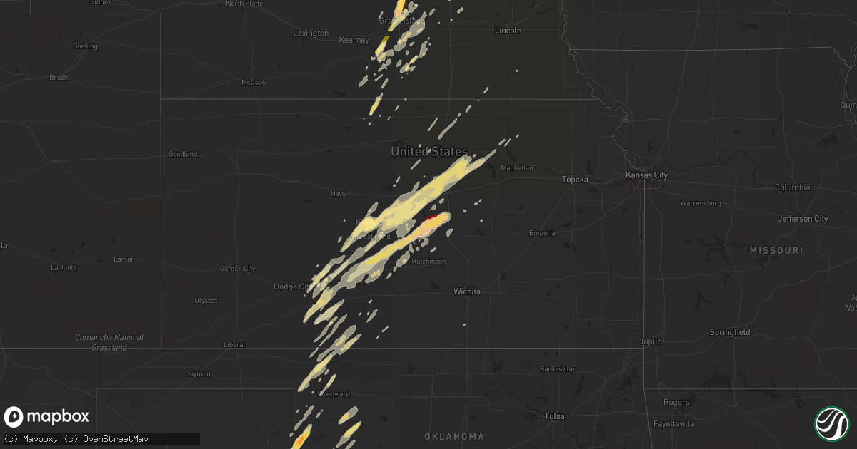
Hail Map in Kansas on November 10, 2012
Get this storm
November 10 map
$229
one time, instant access
Download today. No call, no setup
Keep the $229
Bought the map and want the full workflow? Apply the entire $229 to a subscription within 7 days. None of it is wasted.
Every map, not just this one
This buys you this map. Subscription and you get every map we run, in the markets you choose from a few cities to whole states to nationwide. Plus real-time alerts the moment a storm fires.
Contact data
Name, contact info, occupancy, even credit band for addresses in the footprint. You go from where it hit to who to call.
Become the source they trust
Unlimited branding weather history reports on demand. You already have the documented answer ready for the property owner, and you are the one who showed up with it.
Property data and RoofTrace estimates
Pull up any address you have got, its value and the exact code rules for that jurisdiction, straight from One Click Code. Then RoofTrace estimates the squares, pitch, and roof value, priced the way you price.
Storm reports in Kansas
Kansas
| Date | Description |
|---|---|
| 11/10/20125:55 PM CST | Hail smaller than pea size was also reported. The caller saw small limbs down on the other side of hwy 50/56. |
| 11/10/20125:55 PM CST | A local report indicates 1.00 inch wind near COLDWATER |
| 11/10/20125:42 PM CST | Dime sized hail also occurred with the wind. |
| 11/10/20125:33 PM CST | A local report indicates 1.00 inch wind near 3 E BELLEFONT |
| 11/10/20125:30 PM CST | A local report indicates 60 MPH wind near 3 S BELLEFONT |
| 11/10/20125:30 PM CST | A local report indicates 1.00 inch wind near 3 S BELLEFONT |
| 11/10/20125:25 PM CST | A local report indicates 70 MPH wind near 5 WNW ASH VALLEY |
| 11/10/20124:41 PM CST | A local report indicates 60 MPH wind near DODGE CITY |
| 11/10/20125:16 AM CST | Metal shed blown over near kansas highway 39 and lyons road. |
| 11/10/20125:10 AM CST | A local report indicates 66 MPH wind near CHANUTE AIRPORT |
| 11/09/20128:49 PM CST | Nickel size hail was also reported. |
| 11/09/20128:44 PM CST | Spotter reported shingles blown off roof and front door window and encasement blown me. |
| 11/09/20128:34 PM CST | Ksn weatherlab |
| 11/09/20128:17 PM CST | Accompanied by quarter size hail. |
| 11/09/20128:17 PM CST | Wind gusts to 60 mph were also reported. |
| 11/09/20128:16 PM CST | A local report indicates 70 MPH wind near 2 N STERLING |
| 11/09/20128:08 PM CST | A local report indicates 60 MPH wind near 4 ESE OAK HILL |
| 11/09/20128:01 PM CST | Hail to quarter size was also reported. |
| 11/09/20128:01 PM CST | Wind gusts to 60 mph were also reported. |
| 11/09/20127:52 PM CST | Measured by home weather station. |
| 11/09/20127:43 PM CST | With pea to marble sized hail and heavy rainfall. |
| 11/09/20127:42 PM CST | A local report indicates 1.00 inch wind near 3 WSW HUDSON |
| 11/09/20127:25 PM CST | A local report indicates 60 MPH wind near 1 NNW TESCOTT |
| 11/09/20127:09 PM CST | A local report indicates 64 MPH wind near 6 SSE GUIDE ROCK |
| 11/09/20127:03 PM CST | Carport damaged and blown over house. From social media. |
| 11/09/20127:00 PM CST | Stafford county dispatch advised a dilapidated garage at the senior center was knocked down. The time was estimated based on radar. Radium was also reported without ele |
| 11/09/20126:58 PM CST | A local report indicates 1.00 inch wind near HOLYROOD |
| 11/09/20126:58 PM CST | A local report indicates 1.00 inch wind near 2 N ELLSWORTH |
| 11/09/20126:37 PM CST | Accompanied by golf ball size hail. |
| 11/09/20126:27 PM CST | A local report indicates 65 MPH wind near 5 E KINSLEY |
| 11/09/20126:20 PM CST | A local report indicates 70 MPH wind near 10 NE HOISINGTON |
| 11/09/20126:14 PM CST | A local report indicates 1.00 inch wind near 1 E HOISINGTON |
| 11/09/20126:14 PM CST | Nickel sized hail also occurred with the wind. |
| 11/09/20126:09 PM CST | A local report indicates 1.00 inch wind near HOISINGTON |
| 11/09/20126:07 PM CST | A local report indicates 1.75 inch wind near 3 NW HOISINGTON |
| 11/09/20126:07 PM CST | A local report indicates 60 MPH wind near 3 NW HOISINGTON |
All States Impacted by Hail Map on November 10, 2012
Cities Impacted by Hail Map on November 10, 2012
- Lyons, KS
- Chapman, NE
- Cairo, NE
- Osceola, NE
- Shelby, NE
- Protection, KS
- Mullinville, KS
- Haviland, KS
- Minneola, KS
- Matador, TX
- Kenesaw, NE
- Heartwell, NE
- Juniata, NE
- Holstein, NE
- Crawford, OK
- Durham, OK
- Reydon, OK
- Saronville, NE
- Clay Center, NE
- Esbon, KS
- Bolingbrook, IL
- Plainfield, IL
- Woodridge, IL
- Naperville, IL
- Oswego, IL
- Quanah, TX
- Buffalo, OK
- Fort Supply, OK
- Oakland, NE
- Lyons, NE
- Little River, KS
- Great Bend, KS
- Trumbull, NE
- Harvard, NE
- Raymond, KS
- Vici, OK
- Mutual, OK
- Beemer, NE
- Windom, KS
- Lindsborg, KS
- Marquette, KS
- Alden, KS
- Geneseo, KS
- St John, KS
- Hudson, KS
- Falun, KS
- Lewis, KS
- Chase, KS
- Macksville, KS
- Mcpherson, KS
- Belpre, KS
- Larned, KS
- Ellinwood, KS
- Offerle, KS
- Aurora, IL
- North Aurora, IL
- Batavia, IL
- Warrenville, IL
- Wellington, TX
- Inman, KS
- Crosbyton, TX
- Saint Libory, NE
- Saint Paul, NE
- Palmer, NE
- Grand Island, NE
- Wood River, NE
- Roseland, NE
- Russell, KS
- Silverton, TX
- Rogers, NE
- Schuyler, NE
- Hampton, NE
- Hordville, NE
- Spearville, KS
- Floodwood, MN
- Taloga, OK
- Sterling, KS
- Aurora, NE
- Giltner, NE
- Montgomery, IL
- Hammon, OK
- Laverne, OK
- Briscoe, TX
- Hinckley, IL
- Big Rock, IL
- Elburn, IL
- Hoisington, KS
- Olmitz, KS
- Kinsley, KS
- Hanston, KS
- Spur, TX
- Dickens, TX
- Wilson, KS
- Holyrood, KS
- Lorraine, KS
- Ellsworth, KS
- Sweetwater, OK
- Woodward, OK
- Leedey, OK
- Seiling, OK
- Randolph, KS
- Beverly, KS
- Minneapolis, KS
- Bennington, KS
- Tescott, KS
- Mooreland, OK
- Garfield, KS
- Medicine Lodge, KS
- Shamrock, TX
- Albert, KS
- Kanopolis, KS
- Claflin, KS
- Bushton, KS
- Brookville, KS
- Otis, KS
- Salina, KS
- Wellington, KS
- Inavale, NE
- Red Cloud, NE
- Bladen, NE
- Quitaque, TX
- Phillips, NE
- Wolbach, NE
- Bucklin, KS
- Greensburg, KS
- Fairfield, NE
- Glenvil, NE
- Stafford, KS
- Smith Center, KS
- Lebanon, KS
- Sutton, NE
- Columbus, NE
- Platte Center, NE
- Sandwich, IL
- Plano, IL
- Ford, KS
- Doniphan, NE
- Paducah, TX
- May, OK
- Assaria, KS
- Canadian, TX
- Coldwater, KS
- Freedom, OK
- Hedley, TX
- Mooseheart, IL
- Roaring Springs, TX
- Sawyer, KS
- Duke, OK
- North Bend, NE
- Dodge, NE
- Linwood, NE
- Bellwood, NE
- David City, NE
- Blue Hill, NE
- Lawrence, NE
- Clarkson, NE
- Sharon, OK
- Hastings, NE
- Clarendon, TX
- Wheeler, TX
- Wakefield, KS
- Miltonvale, KS
- Longford, KS
- Lincoln, KS
- Abilene, KS
- Clay Center, KS
- Pawnee Rock, KS
- Solomon, KS
- Minden, NE
- Ashland, KS
- Courtland, KS
- Jamestown, KS
- Norway, KS
- Scandia, KS
- Quail, TX
- Sun City, KS
- Lake City, KS
- Coats, KS
- Arnett, OK
- Fargo, OK
- Gage, OK
- Shattuck, OK
- Beloit, KS
- Silver Creek, NE
- Genoa, NE
- Monroe, NE
- Sylvia, KS
- Lelia Lake, TX
- Iuka, KS
- Byers, KS
- Leigh, NE
- Enterprise, KS
- Hope, KS
- Cumberland, WI
- Mclean, TX
- Wilmore, KS
- Birchwood, WI
- Lakeview, TX
- Erick, OK
- Abbyville, KS
- Plevna, KS
- Downers Grove, IL
- Deweese, NE
- Butler, OK
- Custer City, OK
- Texola, OK
- Gaylord, KS
- Clarks, NE
- Creston, NE
- Bloomington, NE
- Upland, NE
- Franklin, NE
- Alda, NE
- Ayr, NE
- Burr Oak, KS
- West Point, NE
- Barronett, WI
- Yorkville, IL
- Filley, NE
- Archer, NE
- Central City, NE
- Howells, NE
- Cuba, KS
- Pratt, KS
- Olsburg, KS
- Frankfort, KS
- Scribner, NE
- Humphrey, NE
- Gresham, NE
- Campbell, NE
- Tampa, KS
- Concordia, KS
- Agenda, KS
- Belleville, KS
- Fairbury, NE
- Endicott, NE
- Diller, NE
- Marquette, NE
- Barnard, KS
- York, NE
- Memphis, TX
- Polk, NE
- Rice Lake, WI
- Sarona, WI
- Sylvan Grove, KS
- Inland, NE
- Athol, KS
- Wright, KS
- Bison, KS
- Darien, IL
- Gypsum, KS
- Haddam, KS
- Mahaska, KS
- Bradshaw, NE
- Albion, NE
- Hardtner, KS
- West Chicago, IL
- Winfield, IL
- Sugar Grove, IL
- Wheaton, IL
- Afton, TX
- Lockport, IL
- Lemont, IL
- Spalding, NE
- Leonardville, KS
- Rising City, NE
- Simpson, KS
- Glasco, KS
- Cheyenne, OK
- Fullerton, NE
- Morrowville, KS
- Newport, NE
- Riverton, NE


