Hail Map in Bainbridge, GA on November 9, 2025
The weather event in Bainbridge, GA on November 9, 2025 includes Hail and Wind maps. 6 states and 62 cities were impacted and suffered possible damage. The total estimated number of properties impacted is 0.
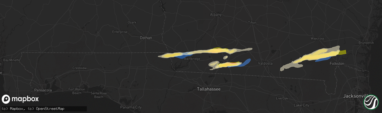
Hail
Wind
0
Estimated number of impacted properties by a 1.00" hail or larger0
Estimated number of impacted properties by a 1.75" hail or larger0
Estimated number of impacted properties by a 2.50" hail or largerStorm reports in Bainbridge, GA
Bainbridge, GA
| Date | Description |
|---|---|
| 11/09/20252:10 PM CST | In the 3500 vada road area... There were large oak trees down... Power lines down... And some roof damage. |
| 11/09/20252:10 PM CST | In the 3500 vada road area... Th |
| 11/09/20252:10 PM CST | In the 3500 vada road |
| 11/09/20251:58 PM CST | The bainbridge raws station tt665 gusted to 69 mph. |
| 11/09/20251:55 PM CST | Awos station kbge bainbridge. |
All States Impacted by Hail Map on November 9, 2025
All Cities Impacted by Hail Map on November 9, 2025
- Benson, NC
- Angier, NC
- Loxley, AL
- Stapleton, AL
- Daphne, AL
- Robertsdale, AL
- Bay Minette, AL
- Cantonment, FL
- Molino, FL
- Bascom, FL
- Malone, FL
- Greenwood, FL
- Defuniak Springs, FL
- Ponce De Leon, FL
- Donalsonville, GA
- Freeport, FL
- Iron City, GA
- Brinson, GA
- Grand Ridge, FL
- Marianna, FL
- Bainbridge, GA
- Climax, GA
- Sneads, FL
- Whigham, GA
- Cairo, GA
- Pelham, GA
- Ochlocknee, GA
- Meigs, GA
- Coolidge, GA
- Thomasville, GA
- Boston, GA
- Pavo, GA
- Barney, GA
- Dixie, GA
- Moultrie, GA
- Quitman, GA
- Morven, GA
- Adel, GA
- Valdosta, GA
- Statenville, GA
- Homerville, GA
- Fargo, GA
- Monticello, FL
- Waycross, GA
- Manor, GA
- Folkston, GA
- Lake Park, GA
- White Oak, GA
- Nahunta, GA
- Waverly, GA
- Attapulgus, GA
- Waynesville, GA
- Dunnsville, VA
- Greenville, FL
- Madison, FL
- Pinetta, FL
- Williamsburg, VA
- Toano, VA
- Gloucester, VA
- Charles City, VA
- Millsboro, DE
- Frankford, DE


