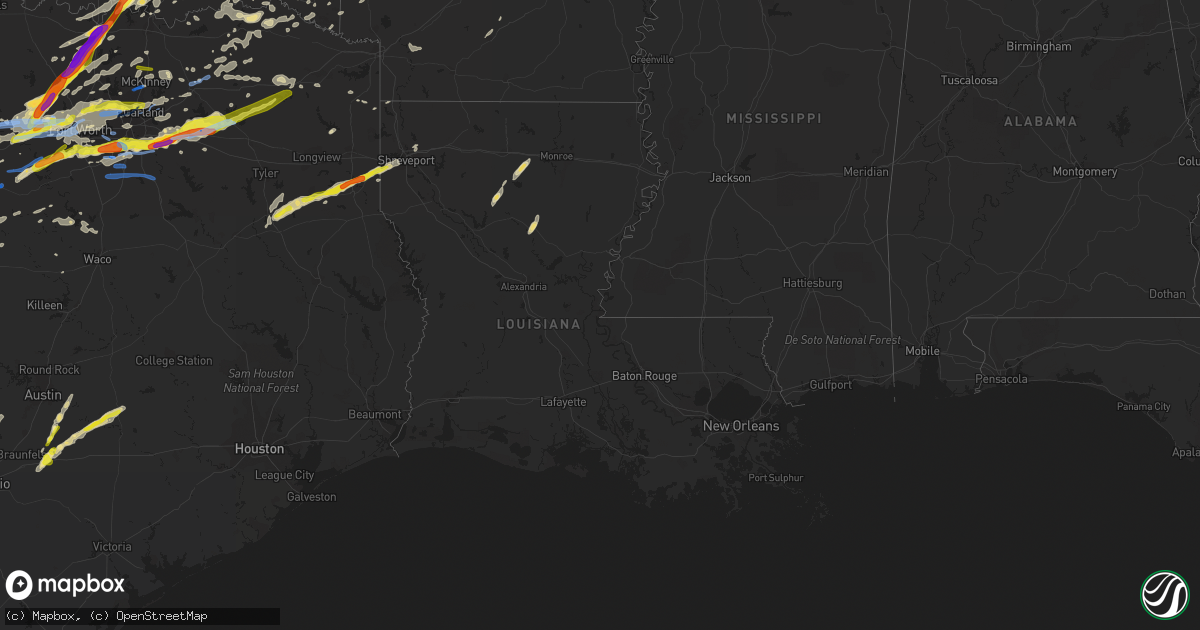
Hail Map in Louisiana on October 20, 2019
Get this storm
October 20 map
$229
one time, instant access
Download today. No call, no setup
Keep the $229
Bought the map and want the full workflow? Apply the entire $229 to a subscription within 7 days. None of it is wasted.
Every map, not just this one
This buys you this map. Subscription and you get every map we run, in the markets you choose from a few cities to whole states to nationwide. Plus real-time alerts the moment a storm fires.
Contact data
Name, contact info, occupancy, even credit band for addresses in the footprint. You go from where it hit to who to call.
Become the source they trust
Unlimited branding weather history reports on demand. You already have the documented answer ready for the property owner, and you are the one who showed up with it.
Property data and RoofTrace estimates
Pull up any address you have got, its value and the exact code rules for that jurisdiction, straight from One Click Code. Then RoofTrace estimates the squares, pitch, and roof value, priced the way you price.
Storm reports in Louisiana
Louisiana
| Date | Description |
|---|---|
| 10/20/20192:56 AM CDT | At 756 PM CDT, a severe thunderstorm was located just east of Beckville, or 7 miles north of Carthage, moving east at 30 mph. HAZARD...60 mph wind gusts and half dollar size hail. SOURCE...Radar indicated. Trees and power lines have been downed near the Fairplay community in Western Panola County with this storm. This storm also continues to exhibit signs of weak rotation, and this warning may be upgraded to a Tornado Warning if it tightens further. IMPACT...Hail damage to vehicles is expected. Expect wind damage to roofs, siding, and trees. Locations impacted include... Carthage, Waskom, Beckville, Deberry, Elysian Fields and Midyett. |
| 10/19/20199:20 PM CDT | Corrects previous tstm wnd dmg report from 1 s red chute. Trees down and roof damage in subdivision near red chute. |
| 10/19/20199:20 PM CDT | Trees down and roof damage in subdivision near red chute. |
| 10/19/20199:19 PM CDT | Trees and powerlines down in both the dogwood subdivision and stockwell place subdivisions. |
| 10/19/20198:55 PM CDT | Asos station kshv shreveport regional airport. |
| 10/19/20198:52 PM CDT | Tree fell on house and displaced residents. |
| 10/19/20198:51 PM CDT | A power line was blown down onto a home in the area of montana street and mlk drive... Which sparked a fire in the attic. The resident was able to safely escape the hom |
| 10/19/20198:50 PM CDT | Large limb down in the office front lawn with several smaller limbs down over the grounds. |
| 10/19/20198:47 PM CDT | Trees and power lines down blocking the road. |
| 10/19/20198:42 PM CDT | An ef-1 tornado touched down along mount olive church road and headed northeast where it intersected buncombe road. Here it caused the most damage uprooting and snappin |
All States Impacted by Hail Map on October 20, 2019
Cities Impacted by Hail Map on October 20, 2019
- Glenallen, MO
- Patton, MO
- Marble Hill, MO
- Brookston, TX
- Okmulgee, OK
- Mounds, OK
- Bristow, OK
- Beggs, OK
- Eldorado, TX
- Tulsa, OK
- Earlsboro, OK
- Catoosa, OK
- Sapulpa, OK
- Prague, OK
- Sperry, OK
- Kellyville, OK
- Collinsville, OK
- Boley, OK
- Depew, OK
- Paden, OK
- Seminole, OK
- Haskell, OK
- Castle, OK
- Bixby, OK
- Ramona, OK
- Oologah, OK
- Claremore, OK
- Okemah, OK
- Shawnee, OK
- Skiatook, OK
- Sand Springs, OK
- Vera, OK
- Owasso, OK
- Talala, OK
- Hardy, AR
- Durant, OK
- Caddo, OK
- Venus, TX
- Alvarado, TX
- Harleton, TX
- Jefferson, TX
- Keller, TX
- Fort Worth, TX
- Junction, TX
- Sonora, TX
- Pecan Gap, TX
- Cooper, TX
- Justin, TX
- Rhome, TX
- Decatur, TX
- Boyd, TX
- Springtown, TX
- Dexter, KS
- Arkansas City, KS
- Maple City, KS
- Cedar Vale, KS
- Carrollton, TX
- Southlake, TX
- Addison, TX
- Lewisville, TX
- North Richland Hills, TX
- Grapevine, TX
- Irving, TX
- Colleyville, TX
- Dallas, TX
- Coppell, TX
- Roanoke, TX
- Flower Mound, TX
- Wasola, MO
- Noble, MO
- Antlers, OK
- Clayton, OK
- Moyers, OK
- Aledo, TX
- Azle, TX
- Millsap, TX
- Weatherford, TX
- Choudrant, LA
- Chatham, LA
- Eros, LA
- Rising Star, TX
- May, TX
- Brownwood, TX
- Mansfield, TX
- Smithville, TX
- Como, TX
- Menard, TX
- Elmore City, OK
- Vinita, OK
- Ada, OK
- Milburn, OK
- Wapanucka, OK
- Coleman, OK
- Tishomingo, OK
- Harviell, MO
- Naylor, MO
- Neelyville, MO
- Poplar Bluff, MO
- Broseley, MO
- Fisk, MO
- Gordon, TX
- Palo Pinto, TX
- Santo, TX
- De Berry, TX
- Beckville, TX
- Greenwood, LA
- Waskom, TX
- Carthage, TX
- Garnett, KS
- Maynard, AR
- Pocahontas, AR
- Plato, MO
- Bucyrus, MO
- Wellston, OK
- Troup, TX
- Shreveport, LA
- Jacksonville, TX
- Rusk, TX
- Henderson, TX
- Bethany, LA
- Keithville, LA
- Laneville, TX
- Dale, TX
- Cedar Creek, TX
- Granbury, TX
- Kingston, OK
- Madill, OK
- Cedar Hill, TX
- Ladonia, TX
- Van Alstyne, TX
- Springdale, AR
- Bentonville, AR
- Cave Springs, AR
- Mckinney, TX
- Arlington, TX
- Kennedale, TX
- Konawa, OK
- Stratford, OK
- Sasakwa, OK
- Wewoka, OK
- Barnsdall, OK
- Graford, TX
- Strawn, TX
- Stonefort, IL
- Era, TX
- Krum, TX
- Sanger, TX
- Gainesville, TX
- Valley View, TX
- Duncan, OK
- Puxico, MO
- Hulbert, OK
- Celeste, TX
- Greenville, TX
- Farmersville, TX
- Eola, TX
- Vancourt, TX
- Paint Rock, TX
- Gouldbusk, TX
- Voss, TX
- Millersview, TX
- Bangs, TX
- Coleman, TX
- San Angelo, TX
- Santa Anna, TX
- Eden, TX
- Fort McKavett, TX
- Joshua, TX
- Crowley, TX
- Luling, TX
- Kingsbury, TX
- Foster, OK
- Terrell, TX
- Kaufman, TX
- Seagoville, TX
- Forney, TX
- Crandall, TX
- Hamilton, TX
- Priddy, TX
- Pottsville, TX
- Comanche, TX
- Mullin, TX
- Goldthwaite, TX
- Dora, MO
- Zanoni, MO
- Broken Arrow, OK
- Westville, OK
- Summers, AR
- Sumner, TX
- Blossom, TX
- Powderly, TX
- Paris, TX
- Paducah, KY
- Brookesmith, TX
- Kenefic, OK
- Pottsboro, TX
- Atoka, OK
- Marietta, OK
- Ardmore, OK
- Mead, OK
- Gordonville, TX
- Lebanon, OK
- Whitesboro, TX
- Detroit, TX
- Rattan, OK
- Hico, TX
- Rochelle, TX
- Brady, TX
- Fischer, TX
- Wimberley, TX
- Spring Branch, TX
- Canyon Lake, TX
- Blanco, TX
- Godley, TX
- Coweta, OK
- Emory, TX
- Yantis, TX
- Sulphur Springs, TX
- Dustin, OK
- Holdenville, OK
- Lamar, OK
- Clarksville, TX
- Dodson, LA
- Cave In Rock, IL
- Smithland, KY
- Brookport, IL
- Salem, KY
- Metropolis, IL
- Elizabethtown, IL
- Golconda, IL
- Marion, KY
- Hampton, KY
- Cushing, OK
- Hugo, OK
- Grant, OK
- Mineral Wells, TX
- Mesquite, TX
- Pauls Valley, OK
- Wynnewood, OK
- England, AR
- Scott, AR
- Edgewood, TX
- Wills Point, TX
- Point, TX
- Rosanky, TX
- Harwood, TX
- Farmington, MO
- Webbers Falls, OK
- Warner, OK
- Norman, OK
- Bossier City, LA
- Haughton, LA
- Carlton, TX
- Rosiclare, IL
- Marlow, OK
- Tolar, TX
- Taft, OK
- Muskogee, OK
- Colbert, OK
- Lohn, TX
- Melvin, TX
- Protem, MO
- Wickes, AR
- Grannis, AR
- Eagletown, OK
- Gillham, AR
- De Queen, AR
- Squires, MO
- Ava, MO
- Thornfield, MO
- Caney, OK
- Jennings, OK
- Mannford, OK
- Stroud, OK
- Agra, OK
- Drumright, OK
- Denison, TX
- Tecumseh, NE
- Sterling, NE
- Alta Vista, KS
- Dwight, KS
- White City, KS
- Junction City, KS
- Richardson, TX
- Brixey, MO
- Stilwell, OK
- Welling, OK
- Bunch, OK
- Meridian, TX
- Jackson, MO
- Oak Ridge, MO
- Altenburg, MO
- Frohna, MO
- Uniontown, MO
- Millersville, MO
- Burfordville, MO
- Old Appleton, MO
- Choctaw, OK
- Oklahoma City, OK
- Newalla, OK
- Hollister, MO
- Branson, MO
- Lockhart, TX
- Cross Plains, TX
- Burkett, TX
- Evansville, IN
- Tamms, IL
- Willow Springs, MO
- Red Oak, TX
- Waxahachie, TX
- Midlothian, TX
- Bagwell, TX
- Wolfe City, TX
- Commerce, TX
- Tullos, LA
- Olla, LA
- Georgetown, LA
- Snow, OK
- Finley, OK
- Paradise, TX
- Ponder, TX
- Fayetteville, AR
- Elkville, IL
- Royalton, IL
- Sesser, IL
- Benton, IL
- Mulkeytown, IL
- De Soto, IL
- Sikeston, MO
- Bertrand, MO
- Thebes, IL
- Villa Ridge, IL
- Charleston, MO
- Ullin, IL
- Miller City, IL
- Cairo, IL
- Mounds, IL
- Pulaski, IL
- Dongola, IL
- Calhoun, LA
- Lindsay, TX
- Naval Air Station Jrb, TX
- Poolville, TX
- Simpson, IL
- Diana, TX
- Bennington, OK
- Mount Pleasant, TX
- Mount Vernon, TX
- Clifton, TX
- Zalma, MO
- Sturdivant, MO
- Telephone, TX
- Iredell, TX
- Walnut Springs, TX
- Sidney, TX
- Salem, MO
- Argyle, TX
- Dublin, TX
- De Leon, TX
- San Saba, TX
- Burleson, TX
- Whitney, TX
- Bonnie, IL
- Wetumka, OK
- Blue Ridge, TX
- Mountain View, MO
- Jonesboro, LA
- Cook, NE
- Festus, MO
- De Soto, MO
- Harrison, AR
- Yale, OK
- Ozona, TX
- Bolivar, MO
- Haworth, OK
- Giddings, TX
- Proctor, OK
- Watts, OK
- Tahlequah, OK
- Lincoln, AR
- Gentry, AR
- Siloam Springs, AR
- Mcloud, OK
- Chandler, OK
- Meeker, OK
- Desoto, TX
- Omaha, AR
- Lockesburg, AR
- Inola, OK
- Hensley, AR
- Sheridan, AR
- Walters, OK
- Seguin, TX
- La Grange, TX
- Waelder, TX
- Morganfield, KY
- Sturgis, KY
- Ridgway, IL
- Belknap, IL
- Burna, KY
- Shawneetown, IL
- Equality, IL
- Eddyville, IL
- Herod, IL
- Grantsburg, IL
- Kevil, KY
- Harrisburg, IL
- Carrier Mills, IL
- Grand Chain, IL
- Omaha, IL
- Ozark, IL
- West Paducah, KY
- New Haven, IL
- Junction, IL
- Bismarck, AR
- Arkadelphia, AR
- Muenster, TX
- Forestburg, TX
- Eufaula, OK
- Davis, OK
- Hanna, OK
- Byars, OK
- Mount Vernon, IL
- Waltonville, IL
- Du Quoin, IL
- Christopher, IL
- Murphysboro, IL
- Opdyke, IL
- Elkins, AR
- Hope, AR
- Lewisville, AR
- King City, MO
- Valley Mills, TX
- Crawford, TX
- West Plains, MO
- Gustine, TX
- Winfield, KS
- Newkirk, OK
- Haltom City, TX
- Edmond, OK
- Guthrie, OK
- Harrah, OK
- Jones, OK
- Pomona, MO
- Malvern, AR
- Donaldson, AR
- Idabel, OK
- Garvin, OK
- Mount Enterprise, TX
- Weleetka, OK
- Macomb, OK
- Bluff Dale, TX
- Lawton, OK
- Farmington, AR
- Prairie Grove, AR
- Campbell, MO
- Malden, MO
- Parker, KS
- The Colony, TX
- Peggs, OK
- Locust Grove, OK
- Park Hill, OK
- Vian, OK
- Cookson, OK
- Braggs, OK
- Gore, OK
- Aubrey, TX
- Lancaster, TX
- Grand Prairie, TX
- Duncanville, TX
- Cresson, TX
- Hurst, TX
- Winnsboro, TX
- Quinlan, TX
- Plano, TX
- Denton, TX
- Scroggins, TX
- Alba, TX
- Pickton, TX
- Lillian, TX
- Wylie, TX
- Haslet, TX
- Hutchins, TX
- Quitman, TX
- Wilmer, TX
- Ferris, TX
- Garland, TX
- Sachse, TX
- Euless, TX
- Bedford, TX
- Dixon, KY
- Clay, KY
- Benton, MO
- Redfield, AR
- Pryor, OK
- Ash Flat, AR
- Mountain Grove, MO
- Kansas, OK
- Colcord, OK
- Morgan, TX
- Rocksprings, TX
- Chandler, IN
- Mount Vernon, IN
- Elberfeld, IN
- Haubstadt, IN
- Henderson, KY
- Camden, AR
- Royse City, TX
- Maud, OK
- Valles Mines, MO
- Delight, AR
- Bokchito, OK
- Desdemona, TX
- Del Rio, TX
- Centerton, AR
- Fort Towson, OK
- Del Valle, TX
- Elgin, TX
- Bethany, OK
- Salina, OK
- Lindsay, OK
- Mill Creek, OK
- Mannsville, OK
- Omaha, TX
- Naples, TX
- Jenks, OK
- Glenpool, OK
- Kiefer, OK
- Fitzhugh, OK
- Luther, OK
- Lipan, TX
- Maysville, OK
- London, TX
- Kissee Mills, MO
- Cedarcreek, MO
- Forsyth, MO
- Green Forest, AR
- Oak Grove, AR
- Ridgedale, MO
- Powersite, MO
- Kirbyville, MO
- Greeley, KS
- Melbourne, AR
- Willard, MO
- Morrisville, MO
- Henryetta, OK
- Traskwood, AR
- Helena, MO
- Cosby, MO
- Huggins, MO
- Graff, MO
- Wayne, OK
- Purcell, OK
- Noble, OK
- Asher, OK
- Hennepin, OK
- Paoli, OK
- Calvin, OK
- Tioga, TX
- Wagoner, OK
- Bearden, AR
- Lead Hill, AR
- Saint Joseph, MO
- Pattonville, TX
- Roxton, TX
- Ben Franklin, TX
- Celina, TX
- Anna, TX
- Gunter, TX
- Linden, TX
- Atlanta, TX
- Whitewater, MO
- Lake Creek, TX
- Okolona, AR
- Chouteau, OK
- Ravenna, TX
- Ivanhoe, TX
- Zephyr, TX
- Early, TX
- Aquilla, TX
- Oktaha, OK
- Boynton, OK
- Morris, OK
- Blanchard, OK
- Murfreesboro, AR
- West, TX
- Abbott, TX
- Bluejacket, OK
- Shell Knob, MO
- Lampe, MO
- Marion, IL
- Thompsonville, IL
- Pittsburg, IL
- Everton, MO
- Broken Bow, OK
- Lavon, TX
- Nevada, TX
- Rockwall, TX
- Uniontown, KY
- Amity, AR
- Kirby, AR
- Elk City, KS
- Sedan, KS
- Berryville, AR
- Spencerville, OK
- Boswell, OK
- Providence, KY
- Porter, OK
- Iola, KS
- Colony, KS
- Welda, KS
- Seymour, MO
- Horatio, AR
- Ranger, TX
- Leopold, MO
- Newhope, AR
- Dierks, AR
- Eminence, MO
- Nashville, AR
- Olive Branch, IL
- Scott City, MO
- Oran, MO
- Huntsville, AR
- Benton, AR
- Yates Center, KS
- Afton, OK
- Chelsea, OK
- Rogers, AR
- Lowell, AR
- Pilot Point, TX
- Canehill, AR
- Little Rock, AR
- Oglesby, TX
- Overbrook, OK
- Thackerville, OK
- Coalgate, OK
- Gainesville, MO
- Gravette, AR
- Decatur, AR
- Gorman, TX
- Canton, TX
- Dike, TX
- Rose, OK
- Klondike, TX
- Lane, OK
- Novice, TX
- Calera, OK
- Lake Dallas, TX
- Little Elm, TX
- Spencer, OK
- Alvord, TX
- Wanette, OK
- Stephenville, TX
- Carmi, IL
- New Harmony, IN
- Poseyville, IN
- Hominy, OK
- Sparks, OK
- Saltillo, TX
- Bivins, TX
- Carbon, TX
- Foreman, AR
- Blue Eye, MO
- Bradleyville, MO
- Rueter, MO
- Arthur City, TX
- Ida, LA
- Checotah, OK
- Peel, AR
- Yellville, AR
- Lane, KS
- Princeton, TX
- Carney, OK
- Maramec, OK
- Terlton, OK
- Tryon, OK
- Arcadia, OK
- Glencoe, OK
- Pawnee, OK
- Meridian, OK
- Stillwater, OK
- Cleveland, OK
- Perkins, OK
- Prue, OK
- Ripley, OK
- Osage, OK
- Council Hill, OK
- Caddo, TX
- Caddo Mills, TX
- Comanche, OK
- Gonzales, TX
- Leesburg, TX
- Pittsburg, TX
- Valera, TX
- Melissa, TX
- Garfield, AR
- Eureka Springs, AR
- West Fork, AR
- Marionville, MO
- Nixa, MO
- Monett, MO
- Mount Vernon, MO
- Clever, MO
- Brookline, MO
- Granby, MO
- Stark City, MO
- Rogersville, MO
- Republic, MO
- Verona, MO
- Neosho, MO
- Springfield, MO
- Aurora, MO
- Billings, MO
- Pierce City, MO
- Highlandville, MO
- Sparta, MO
- Fordland, MO
- Ozark, MO
- Theodosia, MO
- Isabella, MO
- Vanzant, MO
- Drury, MO
- Deer Creek, OK
- Lamont, OK
- Nardin, OK
- Blackwell, OK
- Braman, OK
- Washington, OK
- Alex, OK
- Davenport, OK
- Spavinaw, OK
- Eucha, OK
- Mcalester, OK
- Rowlett, TX
- Campbell, TX
- Maypearl, TX
- Ennis, TX
- Allen, TX
- Frisco, TX
- Fort Gibson, OK
- Twin Oaks, OK
- Oaks, OK
- Barnhart, MO
- Crystal City, MO
- Pevely, MO
- Herculaneum, MO
- Jacob, IL
- Scheller, IL


