Hail Map in Glendale, AZ on October 18, 2015
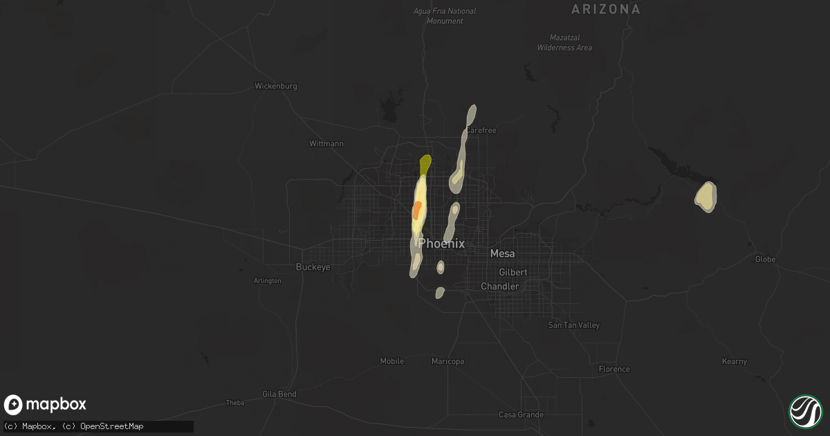
Get this storm
October 18 map
$229
one time, instant access
Download today. No call, no setup
Keep the $229
Bought the map and want the full workflow? Apply the entire $229 to a subscription within 7 days. None of it is wasted.
Every map, not just this one
This buys you this map. Subscription and you get every map we run, in the markets you choose from a few cities to whole states to nationwide. Plus real-time alerts the moment a storm fires.
Contact data
Name, contact info, occupancy, even credit band for addresses in the footprint. You go from where it hit to who to call.
Become the source they trust
Unlimited branding weather history reports on demand. You already have the documented answer ready for the property owner, and you are the one who showed up with it.
Property data and RoofTrace estimates
Pull up any address you have got, its value and the exact code rules for that jurisdiction, straight from One Click Code. Then RoofTrace estimates the squares, pitch, and roof value, priced the way you price.
Storm reports in Glendale, AZ
Glendale, AZ
| Date | Description |
|---|---|
| 10/18/20156:52 PM CDT | Ex-nws employee reports trees down and small less than 3.4 inch hail at 55th ave and northern |
| 10/18/20156:48 PM CDT | Poles down at 51st and camelback. Also 1 4 inch hail and 100ft vis in heavy rain |
| 10/18/20156:43 PM CDT | Quater-half dollar sizd hail at sweetwater and 51st ave. |
| 10/18/20156:30 PM CDT | Power poles down along camelback rd. From 51st to 59th ave. Time estimated. |
| 10/18/20156:25 PM CDT | Public report via facebook of poles down at 51st ave and glendale |
| 10/18/20156:25 PM CDT | Large tree down near 51st avenue and hwy 60. |
| 10/18/20156:14 PM CDT | And street flooding |
| 10/18/20156:13 PM CDT | Half dollar sized hail fell for 15 minutes. Max wind gust est 50 mph. Est 1.25 to 1.49 in. Of rain fell in 20 minutes. |
| 10/18/20156:10 PM CDT | Ex-nws employee reports trees down and pea sized hail at 55th ave and northern |
| 10/18/20156:10 PM CDT | And estimated wind gust of 50 to 60 mph. |
| 10/18/20156:10 PM CDT | And medium sized trees uprooted. |
| 10/18/20156:00 PM CDT | Poles down at 51st and camelback. Also pea sized hail and 100ft visibility in heavy rain |
| 10/18/20156:00 PM CDT | Quater-half dollar sizd hail at sweetwater and 51st ave. |
| 10/17/20157:16 PM CDT | Public report via facebook of poles down at 51st ave and glendale |
All States Impacted by Hail Map on October 18, 2015
All Cities Impacted by Hail Map on October 18, 2015
- Overton, NV
- Laughlin, NV
- Pima, AZ
- Willcox, AZ
- Amargosa Valley, NV
- Phoenix, AZ
- Roosevelt, AZ
- Miami, AZ
- Bullhead City, AZ
- Kingman, AZ
- Golden Valley, AZ
- Nipton, CA
- Searchlight, NV
- Alton, UT
- Dolan Springs, AZ
- Peach Springs, AZ
- Hurricane, UT
- Sells, AZ
- Casa Grande, AZ
- Littlefield, AZ
- Fort Mohave, AZ
- Glendale, AZ
- Springdale, UT
- Datil, NM
- Cave Creek, AZ
- Page, AZ
- Sanger, CA
- Maricopa, AZ
- Peridot, AZ
- Tollhouse, CA
- Pioche, NV
- Panaca, NV
- Mohave Valley, AZ
- Scottsdale, AZ
- Henderson, NV
- Needles, CA
- Laveen, AZ
- San Carlos, AZ
- New Harmony, UT
- Globe, AZ
- Safford, AZ
- New River, AZ
- Marana, AZ
- Las Vegas, NV
- Nellis Afb, NV
- Cal Nev Ari, NV
- Orderville, UT
- Mesa, AZ
- Tempe, AZ
- Payson, AZ
- Young, AZ
- Caliente, NV
- Tucson, AZ


