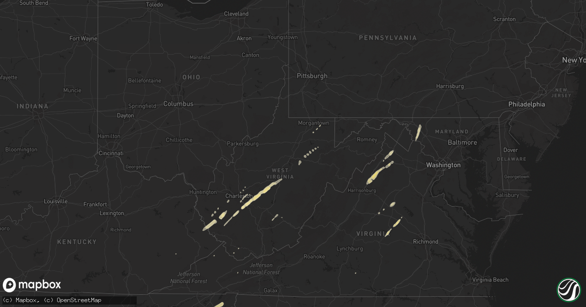
Hail Map in West Virginia on October 18, 2012
Get this storm
October 18 map
$229
one time, instant access
Download today. No call, no setup
Keep the $229
Bought the map and want the full workflow? Apply the entire $229 to a subscription within 7 days. None of it is wasted.
Every map, not just this one
This buys you this map. Subscription and you get every map we run, in the markets you choose from a few cities to whole states to nationwide. Plus real-time alerts the moment a storm fires.
Contact data
Name, contact info, occupancy, even credit band for addresses in the footprint. You go from where it hit to who to call.
Become the source they trust
Unlimited branding weather history reports on demand. You already have the documented answer ready for the property owner, and you are the one who showed up with it.
Property data and RoofTrace estimates
Pull up any address you have got, its value and the exact code rules for that jurisdiction, straight from One Click Code. Then RoofTrace estimates the squares, pitch, and roof value, priced the way you price.
Storm reports in West Virginia
West Virginia
| Date | Description |
|---|---|
| 10/18/20124:33 PM CDT | A local report indicates 1.00 inch wind near 2 WNW HOVATTER |
| 10/18/20124:30 PM CDT | Time modified based on radar. Relayed by wboy. |
| 10/18/20124:20 PM CDT | A local report indicates 1.00 inch wind near MOATSVILLE |
| 10/18/20124:17 PM CDT | Up to quarter size hail in the town of charmco |
| 10/18/20124:15 PM CDT | State police reported hail up to quarter size covering the ground. |
| 10/18/20124:13 PM CDT | 1 inch hail reported near barbour county fairgrounds |
| 10/18/20122:05 PM CDT | Cars damaged at car lot. Quarter size hail |
| 10/18/20121:54 PM CDT | Estimated quarter to half dollar sized hail. |
All States Impacted by Hail Map on October 18, 2012
Cities Impacted by Hail Map on October 18, 2012
- Hampton, TN
- Butler, TN
- Lizemores, WV
- Glen, WV
- Indore, WV
- Pond Gap, WV
- San Perlita, TX
- Raymondville, TX
- Louisa, VA
- Lyford, TX
- Johnson City, TN
- Clendenin, WV
- Pharr, TX
- Mcallen, TX
- Hidalgo, TX
- Mission, TX
- Seth, WV
- Grundy, VA
- Masontown, WV
- Philippi, WV
- Moatsville, WV
- Edinburg, TX
- La Villa, TX
- Elsa, TX
- Donna, TX
- Mercedes, TX
- Edcouch, TX
- Weslaco, TX
- Elizabethton, TN
- Madison, WV
- Sumerco, WV
- Alum Creek, WV
- Sod, WV
- Davy, WV
- Welch, WV
- Columbia, VA
- Kents Store, VA
- Chapmanville, WV
- Harts, WV
- Bremo Bluff, VA
- New Canton, VA
- Fork Union, VA
- Elkview, WV
- Charleston, WV
- Charlottesville, VA
- San Juan, TX
- Stephens City, VA
- Winchester, VA
- Duck, WV
- Clay, WV
- Kiahsville, WV
- Dunlow, WV
- Bentonville, VA
- Front Royal, VA
- Lexington, NC
- Hernshaw, WV
- Winifrede, WV
- Ranger, WV
- Knoxville, MD
- Middletown, MD
- Myersville, MD
- Jefferson, MD
- Burkittsville, MD
- Dingess, WV
- Somerset, VA
- Gordonsville, VA
- Orange, VA
- Kermit, WV
- Williamson, WV
- Breeden, WV
- Lenore, WV
- Tad, WV
- Frametown, WV
- Blount, WV
- Bomont, WV
- Drybranch, WV
- Comfort, WV
- Mammoth, WV
- Belle, WV
- Cedar Grove, WV
- Eskdale, WV
- Hansford, WV
- East Bank, WV
- Cabin Creek, WV
- Sutton, WV
- Birch River, WV
- Glasgow, WV
- Little Birch, WV
- Bickmore, WV
- Pratt, WV
- Broadway, VA
- Luray, VA
- Timberville, VA
- Fort Valley, VA
- Mount Jackson, VA
- New Market, VA
- Big Creek, WV
- Winston Salem, NC
- Encino, TX
- San Isidro, TX
- Jeffrey, WV
- Danville, WV
- Linn, TX
- Armstrong, TX
- Lovely, KY
- Charmco, WV
- Rainelle, WV
- Jonesborough, TN
- Volga, WV
- Buckhannon, WV
- Harlingen, TX
- Sebastian, TX
- Shenandoah, VA
- Pilgrim, KY
- Brunswick, MD
- Smithsburg, MD
- Danese, WV
- Rupert, WV
- Nathalie, VA
- Morgantown, WV
- Independence, WV
- Port Mansfield, TX
- Midkiff, WV
- Strasburg, VA
- Tannersville, VA
- Reedsville, WV
- Limestone, TN
- Chuckey, TN
- Telford, TN
- Carrie, KY
- Keswick, VA
- Raysal, WV
- Logan, WV
- Yolyn, WV
- Clothier, WV
- Stollings, WV
- Middletown, VA
- French Creek, WV
- Los Alamos, NM
- Santa Fe, NM
- Tererro, NM
- Glorieta, NM
- Lamy, NM
- Pecos, NM


