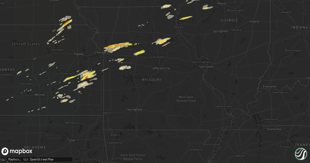
Hail Map in Missouri on October 14, 2017
Get this storm
October 14 map
$229
one time, instant access
Download today. No call, no setup
Keep the $229
Bought the map and want the full workflow? Apply the entire $229 to a subscription within 7 days. None of it is wasted.
Every map, not just this one
This buys you this map. Subscription and you get every map we run, in the markets you choose from a few cities to whole states to nationwide. Plus real-time alerts the moment a storm fires.
Contact data
Name, contact info, occupancy, even credit band for addresses in the footprint. You go from where it hit to who to call.
Become the source they trust
Unlimited branding weather history reports on demand. You already have the documented answer ready for the property owner, and you are the one who showed up with it.
Property data and RoofTrace estimates
Pull up any address you have got, its value and the exact code rules for that jurisdiction, straight from One Click Code. Then RoofTrace estimates the squares, pitch, and roof value, priced the way you price.
Storm reports in Missouri
Missouri
| Date | Description |
|---|---|
| 10/14/20176:21 PM CDT | Delayed report...trees down and debris in road south of harrisonville. Report via social media. Time estimated to radar. |
| 10/14/20176:20 PM CDT | A local report indicates 60 MPH wind near PLEASANT HILL |
| 10/14/20176:18 PM CDT | Delayed report. Roof damage to house in orrick. Time estimated to radar. |
| 10/14/20176:13 PM CDT | A local report indicates 65 MPH wind near GREENWOOD |
| 10/14/20175:40 PM CDT | A local report indicates 60 MPH wind near 1 NNE CLAYCOMO |
| 10/14/20175:31 PM CDT | A local report indicates 65 MPH wind near KANSAS CITY DOWNTOWN |
| 10/14/20175:29 PM CDT | Delayed report...multiple trees down on roadways. Relocated a full 110 gallon water tank a significant distance from original location. Report via social media. |
| 10/14/20175:19 PM CDT | Car crashed into a large tree branch that was down on the highway. |
| 10/14/20175:15 PM CDT | A local report indicates 60 MPH wind near LIBERTY |
| 10/14/20175:15 PM CDT | Delayed report...reported at i-29 and 69 highway. |
| 10/14/20175:11 PM CDT | Delayed report...12 inch branch down at worlds of fun. Reported via social media. Time estimated to radar. |
| 10/14/20175:11 PM CDT | The sign of a fairfield inn across from worlds of fun was blown over. Photos came to our office via twitter. |
| 10/14/20175:11 PM CDT | A farmstead was damaged and power lines down just east of gorin. Possible tornado. First call came in at 512 pm. |
| 10/14/20174:55 PM CDT | Large tree branch blown down onto highway 15 about a mile north of edina. |
| 10/14/20174:46 PM CDT | Ef1 tornado with winds of 95 mph was identified. Tornado was short lived and caused damage to two outbuildings and a grain silo. The length of path was .1 miles and 10 |
| 10/14/20174:36 PM CDT | Power lines down in millard. |
| 10/13/201710:45 PM CDT | Large tree down. Social media report. |
| 10/13/201710:30 PM CDT | Two large trees fell on two vehicles. Time approximate. |
| 10/13/20179:46 PM CDT | Dispatch reports a tree over powerlines in california. |
| 10/13/20179:03 PM CDT | A local report indicates 58 MPH wind near SEDALIA |
| 10/13/20178:50 PM CDT | A local report indicates 65 MPH wind near GREEN RIDGE |
| 10/13/20178:30 PM CDT | Large tree snapped and other large limbs down. Social media report. |
| 10/13/20178:20 PM CDT | Social media report. |
| 10/13/20178:20 PM CDT | Limbs and small trees down on local gravel road. Social media report. |
| 10/13/20178:16 PM CDT | Several large tree limbs down on route c between highway 24 and route m. Social media report. |
| 10/13/20178:13 PM CDT | Several trees down across the area. Social media report. |
All States Impacted by Hail Map on October 14, 2017
Cities Impacted by Hail Map on October 14, 2017
- Caldwell, KS
- Bluff City, KS
- Humboldt, NE
- Purdin, MO
- Brighton, IA
- Nelson, MO
- Marshall, MO
- Slater, MO
- Howard, KS
- Beattie, KS
- Home, KS
- Pretty Prairie, KS
- Matfield Green, KS
- Table Rock, NE
- Burchard, NE
- Pawnee City, NE
- Du Bois, NE
- Axtell, KS
- Summerfield, KS
- West Burlington, IA
- Gladstone, IL
- Burlington, IA
- Garnett, KS
- Carman, IL
- Smithshire, IL
- Monmouth, IL
- Kirkwood, IL
- Leon, KS
- Piedmont, KS
- Brunswick, MO
- Green Ridge, MO
- Windsor, MO
- Leeton, MO
- Mount Sterling, IA
- Cantril, IA
- Arbela, MO
- Kahoka, MO
- Bonaparte, IA
- Farmington, IA
- Luray, MO
- Memphis, MO
- Canute, OK
- Butler, OK
- Randolph, KS
- Latham, KS
- Chilhowee, MO
- Blairstown, MO
- Knob Noster, MO
- Sibley, MO
- Richmond, MO
- Orrick, MO
- Camden, MO
- Madison, KS
- Dahinda, IL
- Gilson, IL
- Interior, SD
- Franklin, MO
- Glasgow, MO
- Hardin, MO
- Lyons, KS
- Iola, KS
- Colony, KS
- Kincaid, KS
- La Harpe, KS
- Neosho Falls, KS
- Yates Center, KS
- Le Roy, KS
- Piqua, KS
- Frankfort, KS
- Rayville, MO
- Knoxville, IL
- Saint Patrick, MO
- Williamstown, MO
- Green, KS
- Westphalia, KS
- Greeley, KS
- Geneseo, KS
- Chase, KS
- Liberty, NE
- Steinauer, NE
- Taloga, OK
- Grenola, KS
- Moline, KS
- Fall River, KS
- Argyle, IA
- Montrose, IA
- Haven, KS
- Berwick, IL
- Maquon, IL
- Galesburg, IL
- Media, IL
- Cameron, IL
- Oquawka, IL
- Raritan, IL
- Roseville, IL
- East Galesburg, IL
- Stronghurst, IL
- Abingdon, IL
- Lomax, IL
- Biggsville, IL
- Victoria, IL
- Lehigh, KS
- Hillsboro, KS
- Columbus Junction, IA
- Cordell, OK
- Foss, OK
- Dill City, OK
- Basehor, KS
- Marion, KS
- Princeton, KS
- Williamsburg, KS
- Leonardville, KS
- Clay Center, KS
- Burlington, KS
- Westmoreland, KS
- Olsburg, KS
- Hutchinson, KS
- Norborne, MO
- Greenwood, MO
- Pleasant Hill, MO
- Cuba, IL
- Marietta, IL
- Fairview, IL
- London Mills, IL
- Avon, IL
- Smithfield, IL
- Canton, IL
- Ellisville, IL
- Blue Rapids, KS
- Baileyville, KS
- Marysville, KS
- Novinger, MO
- Kirksville, MO
- Liberty, MO
- Excelsior Springs, MO
- Kearney, MO
- Carrollton, MO
- Kansas City, MO
- Holden, MO
- Centerview, MO
- Warrensburg, MO
- Odessa, MO
- Paris, MO
- Moberly, MO
- Holliday, MO
- Madison, MO
- Waverly, KS
- Windom, KS
- Burns, KS
- Sawyer, KS
- Hartford, KS
- Stoutsville, MO
- Fredonia, KS
- Potwin, KS
- Olpe, KS
- Bates City, MO
- Lone Jack, MO
- Kingsville, MO
- Sayre, OK
- Lebo, KS
- Oxford, KS
- Winfield, KS
- Beaumont, KS
- Council Grove, KS
- Kadoka, SD
- Wataga, IL
- Oneida, IL
- Moundridge, KS
- Drexel, MO
- Louisburg, KS
- West Point, IL
- Augusta, IL
- Plymouth, IL
- Bowen, IL
- Loraine, IL
- Keosauqua, IA
- Richmond, KS
- New Cambria, KS
- Fontana, KS
- Welda, KS
- Parker, KS
- Centerville, KS
- Osawatomie, KS
- Ottawa, KS
- Rantoul, KS
- Lane, KS
- Wellington, KS
- Inman, KS
- Mcpherson, KS
- New London, IA
- Mount Union, IA
- Gorin, MO
- Wyaconda, MO
- Midland, SD
- Belvidere, SD
- Cunningham, KS
- Hamilton, KS
- Mount Hope, KS
- Mendon, IL
- Sutter, IL
- Ursa, IL
- Monticello, MO
- La Belle, MO
- Corn, OK
- Severy, KS
- Monroe City, MO
- Herington, KS
- White City, KS
- Brookfield, MO
- Buckner, MO
- Independence, MO
- Missouri City, MO
- Henrietta, MO
- Waterville, KS
- Huntsville, MO
- Spring Hill, KS
- Bucyrus, KS
- Santa Fe, MO
- Perry, MO
- New Boston, MO
- Elk Creek, NE
- Rosalia, KS
- Marquette, KS
- Lindsborg, KS
- Hydro, OK
- Carter, OK
- Elk City, OK
- Blue Mound, KS
- Archie, MO
- Harrisonville, MO
- Eureka, KS
- Moran, KS
- Prescott, IA
- Lenox, IA
- Corning, IA
- Longton, KS
- Onaga, KS
- Mound City, KS
- Winigan, MO
- Seneca, KS
- Bern, KS
- De Witt, MO
- Arrow Rock, MO
- Sweet Springs, MO
- Little York, IL
- Seaton, IL
- Wall, SD
- Vermillion, KS
- Colony, OK
- Creston, IA
- Clinton, MO
- Clinton, OK
- Mayfield, KS
- Centralia, MO
- Thompson, MO
- Mexico, MO
- Geneseo, IL
- Alexis, IL
- Gerlaw, IL
- Gridley, KS
- Melvern, KS
- Gilliam, MO
- Ishpeming, MI
- Champion, MI


