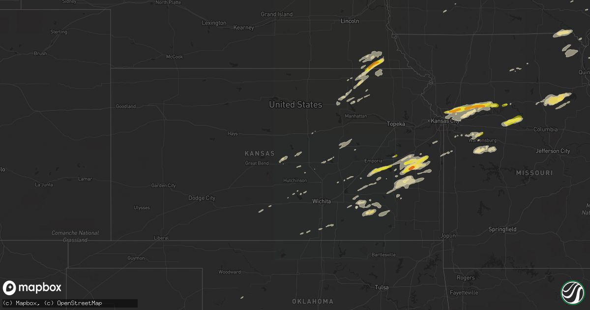
Hail Map in Kansas on October 14, 2017
Get this storm
October 14 map
$229
one time, instant access
Download today. No call, no setup
Keep the $229
Bought the map and want the full workflow? Apply the entire $229 to a subscription within 7 days. None of it is wasted.
Every map, not just this one
This buys you this map. Subscription and you get every map we run, in the markets you choose from a few cities to whole states to nationwide. Plus real-time alerts the moment a storm fires.
Contact data
Name, contact info, occupancy, even credit band for addresses in the footprint. You go from where it hit to who to call.
Become the source they trust
Unlimited branding weather history reports on demand. You already have the documented answer ready for the property owner, and you are the one who showed up with it.
Property data and RoofTrace estimates
Pull up any address you have got, its value and the exact code rules for that jurisdiction, straight from One Click Code. Then RoofTrace estimates the squares, pitch, and roof value, priced the way you price.
Storm reports in Kansas
Kansas
| Date | Description |
|---|---|
| 10/14/20176:59 PM CDT | Snapped power poles reported |
| 10/14/20176:41 PM CDT | A local report indicates 60 MPH wind near YATES CENTER |
| 10/14/20176:38 PM CDT | 1 mile west of garnett. |
| 10/14/20176:35 PM CDT | 70-80 mph estimated |
| 10/14/20176:33 PM CDT | Correction to previous hail report from garnett. |
| 10/14/20176:33 PM CDT | West side of garnett. |
| 10/14/20176:13 PM CDT | 1 mile of utility poles down on p rd with multiple trees blown down blocking roadways nnw of the eureka lake area |
| 10/14/20176:10 PM CDT | 4 power poles snapped 2 miles south of winfield city lake |
| 10/14/20176:08 PM CDT | Farm outbuilding blown apart. |
| 10/14/20176:08 PM CDT | Estimated 60-70 mph winds |
| 10/14/20176:05 PM CDT | 12 inch+ diameter tree down near base. Several limbs of 4-6 in diamater broken. |
| 10/14/20176:05 PM CDT | Wind gust of approximately 70mph. 8 inch diameter treelimb broken. |
| 10/14/20176:01 PM CDT | Large tree snapped |
| 10/14/20175:55 PM CDT | Power pole snapped |
| 10/14/20175:37 PM CDT | 60-70 estimated wind speed |
| 10/14/20175:26 PM CDT | Large tree down at 166th and evans rd. 20 inches in diameter. |
| 10/14/20175:19 PM CDT | Social media report of 6 inch tree limb down. Dispatch relayed multiple tree limbs and power lines down in the town. Radar estimated time. |
| 10/14/20175:12 PM CDT | Large tree down over valley street in southeast wamego. |
| 10/14/20175:09 PM CDT | Delayed report. Mesonet station kukl... 2 nne new strawn. |
| 10/14/20174:55 PM CDT | Relayed by the em. |
| 10/14/20174:49 PM CDT | Small outbuildings blown down. Shingles blown off of roof. Location near 16th and fauna road... Just west of john redmond reservoir. |
| 10/14/20174:46 PM CDT | Powerpoles down. |
| 10/14/20174:46 PM CDT | Semi truck jack knifed at mile marker 116 and us highway 75. No injuries were reported. Time estimated by radar. |
| 10/14/20174:43 PM CDT | A local report indicates 58 MPH wind near 3 SW BASEHOR |
| 10/14/20174:39 PM CDT | Damage to a large tree... Several branches down |
| 10/14/20174:20 PM CDT | Delayed report. Multiple reports of power lines down... Trees down. Generally north of 9th st. And east of iowa street. |
| 10/14/20174:10 PM CDT | Estimated 60mph wind gust verified |
| 10/14/20173:55 PM CDT | 3 inch branches down |
| 10/14/201710:05 AM CDT | *** 1 inj *** delayed report from dispatch of a fed ex truck being blown into the median on united states highway 54. Driver was transported to the hospital. Additional |
| 10/13/20177:28 PM CDT | Shingles blown off roof. Also reported multiple power outages across linn county. |
| 10/13/20177:26 PM CDT | Multiple trees down at 300 rd and k-7 highway. Time estimated to radar. |
| 10/13/20177:18 PM CDT | 72mph wind gust reported at central schools |
| 10/13/20177:08 PM CDT | Relayed report of utility poles down. |
| 10/13/20177:02 PM CDT | Relayed report of power lines down. Radar estimated time. |
All States Impacted by Hail Map on October 14, 2017
Cities Impacted by Hail Map on October 14, 2017
- Caldwell, KS
- Bluff City, KS
- Humboldt, NE
- Purdin, MO
- Brighton, IA
- Nelson, MO
- Marshall, MO
- Slater, MO
- Howard, KS
- Beattie, KS
- Home, KS
- Pretty Prairie, KS
- Matfield Green, KS
- Table Rock, NE
- Burchard, NE
- Pawnee City, NE
- Du Bois, NE
- Axtell, KS
- Summerfield, KS
- West Burlington, IA
- Gladstone, IL
- Burlington, IA
- Garnett, KS
- Carman, IL
- Smithshire, IL
- Monmouth, IL
- Kirkwood, IL
- Leon, KS
- Piedmont, KS
- Brunswick, MO
- Green Ridge, MO
- Windsor, MO
- Leeton, MO
- Mount Sterling, IA
- Cantril, IA
- Arbela, MO
- Kahoka, MO
- Bonaparte, IA
- Farmington, IA
- Luray, MO
- Memphis, MO
- Canute, OK
- Butler, OK
- Randolph, KS
- Latham, KS
- Chilhowee, MO
- Blairstown, MO
- Knob Noster, MO
- Sibley, MO
- Richmond, MO
- Orrick, MO
- Camden, MO
- Madison, KS
- Dahinda, IL
- Gilson, IL
- Interior, SD
- Franklin, MO
- Glasgow, MO
- Hardin, MO
- Lyons, KS
- Iola, KS
- Colony, KS
- Kincaid, KS
- La Harpe, KS
- Neosho Falls, KS
- Yates Center, KS
- Le Roy, KS
- Piqua, KS
- Frankfort, KS
- Rayville, MO
- Knoxville, IL
- Saint Patrick, MO
- Williamstown, MO
- Green, KS
- Westphalia, KS
- Greeley, KS
- Geneseo, KS
- Chase, KS
- Liberty, NE
- Steinauer, NE
- Taloga, OK
- Grenola, KS
- Moline, KS
- Fall River, KS
- Argyle, IA
- Montrose, IA
- Haven, KS
- Berwick, IL
- Maquon, IL
- Galesburg, IL
- Media, IL
- Cameron, IL
- Oquawka, IL
- Raritan, IL
- Roseville, IL
- East Galesburg, IL
- Stronghurst, IL
- Abingdon, IL
- Lomax, IL
- Biggsville, IL
- Victoria, IL
- Lehigh, KS
- Hillsboro, KS
- Columbus Junction, IA
- Cordell, OK
- Foss, OK
- Dill City, OK
- Basehor, KS
- Marion, KS
- Princeton, KS
- Williamsburg, KS
- Leonardville, KS
- Clay Center, KS
- Burlington, KS
- Westmoreland, KS
- Olsburg, KS
- Hutchinson, KS
- Norborne, MO
- Greenwood, MO
- Pleasant Hill, MO
- Cuba, IL
- Marietta, IL
- Fairview, IL
- London Mills, IL
- Avon, IL
- Smithfield, IL
- Canton, IL
- Ellisville, IL
- Blue Rapids, KS
- Baileyville, KS
- Marysville, KS
- Novinger, MO
- Kirksville, MO
- Liberty, MO
- Excelsior Springs, MO
- Kearney, MO
- Carrollton, MO
- Kansas City, MO
- Holden, MO
- Centerview, MO
- Warrensburg, MO
- Odessa, MO
- Paris, MO
- Moberly, MO
- Holliday, MO
- Madison, MO
- Waverly, KS
- Windom, KS
- Burns, KS
- Sawyer, KS
- Hartford, KS
- Stoutsville, MO
- Fredonia, KS
- Potwin, KS
- Olpe, KS
- Bates City, MO
- Lone Jack, MO
- Kingsville, MO
- Sayre, OK
- Lebo, KS
- Oxford, KS
- Winfield, KS
- Beaumont, KS
- Council Grove, KS
- Kadoka, SD
- Wataga, IL
- Oneida, IL
- Moundridge, KS
- Drexel, MO
- Louisburg, KS
- West Point, IL
- Augusta, IL
- Plymouth, IL
- Bowen, IL
- Loraine, IL
- Keosauqua, IA
- Richmond, KS
- New Cambria, KS
- Fontana, KS
- Welda, KS
- Parker, KS
- Centerville, KS
- Osawatomie, KS
- Ottawa, KS
- Rantoul, KS
- Lane, KS
- Wellington, KS
- Inman, KS
- Mcpherson, KS
- New London, IA
- Mount Union, IA
- Gorin, MO
- Wyaconda, MO
- Midland, SD
- Belvidere, SD
- Cunningham, KS
- Hamilton, KS
- Mount Hope, KS
- Mendon, IL
- Sutter, IL
- Ursa, IL
- Monticello, MO
- La Belle, MO
- Corn, OK
- Severy, KS
- Monroe City, MO
- Herington, KS
- White City, KS
- Brookfield, MO
- Buckner, MO
- Independence, MO
- Missouri City, MO
- Henrietta, MO
- Waterville, KS
- Huntsville, MO
- Spring Hill, KS
- Bucyrus, KS
- Santa Fe, MO
- Perry, MO
- New Boston, MO
- Elk Creek, NE
- Rosalia, KS
- Marquette, KS
- Lindsborg, KS
- Hydro, OK
- Carter, OK
- Elk City, OK
- Blue Mound, KS
- Archie, MO
- Harrisonville, MO
- Eureka, KS
- Moran, KS
- Prescott, IA
- Lenox, IA
- Corning, IA
- Longton, KS
- Onaga, KS
- Mound City, KS
- Winigan, MO
- Seneca, KS
- Bern, KS
- De Witt, MO
- Arrow Rock, MO
- Sweet Springs, MO
- Little York, IL
- Seaton, IL
- Wall, SD
- Vermillion, KS
- Colony, OK
- Creston, IA
- Clinton, MO
- Clinton, OK
- Mayfield, KS
- Centralia, MO
- Thompson, MO
- Mexico, MO
- Geneseo, IL
- Alexis, IL
- Gerlaw, IL
- Gridley, KS
- Melvern, KS
- Gilliam, MO
- Ishpeming, MI
- Champion, MI


