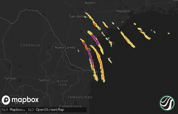
Hail Map in Texas on October 12, 2018
The weather event in Texas on October 12, 2018 includes Hail map. 2 states and 17 cities were impacted and suffered possible damage. The total estimated number of properties impacted is 1,263.

Hail
1,263
Estimated number of impacted properties by a 1.00" hail or larger1,805
Estimated number of impacted properties by a 1.75" hail or larger100
Estimated number of impacted properties by a 2.50" hail or largerStorm reports in Texas
Texas
| Date | Description |
|---|---|
| 10/12/20186:56 AM CDT | At 1155 PM CDT, a severe thunderstorm was located 16 miles north of Dryden, moving east at 15 mph. HAZARD...Tennis ball size hail and 60 mph wind gusts. SOURCE...Radar indicated. IMPACT...People and animals outdoors will be injured. Expect hail damage to roofs, siding, windows, and vehicles. Expect wind damage to roofs, siding, and trees. Locations impacted include... Terrell County Gas Plant. |
| 10/12/20185:56 AM CDT | At 1056 PM CDT, a severe thunderstorm was located 7 miles north of Sanderson, moving east at 25 mph. HAZARD...Ping pong ball size hail and 60 mph wind gusts. SOURCE...Radar indicated. IMPACT...People and animals outdoors will be injured. Expect hail damage to roofs, siding, windows, and vehicles. Expect wind damage to roofs, siding, and trees. Locations impacted include... Sanderson. |
| 10/12/20185:27 AM CDT | At 1026 PM CDT, a severe thunderstorm was located 27 miles northeast of Marathon, or 31 miles south of Fort Stockton, moving northeast at 25 mph. HAZARD...60 mph wind gusts and half dollar size hail. SOURCE...Radar indicated. IMPACT...Hail damage to vehicles is expected. Expect wind damage to roofs, siding, and trees. This severe thunderstorm will remain over mainly rural areas of south central Pecos County. |
| 10/12/20184:58 AM CDT | At 957 PM CDT, a severe thunderstorm was located over US HWY 90, 22 miles west of Sanderson, moving east at 15 mph. HAZARD...60 mph wind gusts and half dollar size hail. SOURCE...Radar indicated. IMPACT...Hail damage to vehicles is expected. Expect wind damage to roofs, siding, and trees. Locations impacted include... Sanderson. |
| 10/12/20184:51 AM CDT | At 950 PM CDT, a severe thunderstorm was located 13 miles southwest of Fort Stockton, moving northeast at 25 mph. HAZARD...60 mph wind gusts and half dollar size hail. SOURCE...Radar indicated. IMPACT...Hail damage to vehicles is expected. Expect wind damage to roofs, siding, and trees. Locations impacted include... Fort Stockton and Fort Stockton-Pecos County Airport. This includes Interstate 10 between mile markers 254 and 287. |
| 10/12/20184:20 AM CDT | At 920 PM CDT, a severe thunderstorm was located near Marathon, or 20 miles southeast of Alpine, moving east at 30 mph. HAZARD...60 mph wind gusts and half dollar size hail. SOURCE...Radar indicated. IMPACT...Hail damage to vehicles is expected. Expect wind damage to roofs, siding, and trees. Locations impacted include... Marathon. |
| 10/12/20184:05 AM CDT | Downed power lines at scr 1083 and fm 307. Scattered sign damaged and collapsed carport in town. |
| 10/12/20184:05 AM CDT | At 905 PM CDT, a severe thunderstorm was located 17 miles east of Marathon, or 34 miles west of Sanderson, moving northeast at 20 mph. HAZARD...60 mph wind gusts and half dollar size hail. SOURCE...Radar indicated. IMPACT...Hail damage to vehicles is expected. Expect wind damage to roofs, siding, and trees. This severe thunderstorm will remain over mainly rural areas of south central Pecos and northeastern Brewster Counties. |
| 10/12/20183:55 AM CDT | At 854 PM CDT, a severe thunderstorm was located over US HWY 67, 24 miles northeast of Alpine, moving northeast at 20 mph. HAZARD...60 mph wind gusts and half dollar size hail. SOURCE...Radar indicated. IMPACT...Hail damage to vehicles is expected. Expect wind damage to roofs, siding, and trees. Locations impacted include... Sierra Madera. |
| 10/12/20183:09 AM CDT | At 808 PM CDT, a severe thunderstorm was located 16 miles south of Marathon, or 32 miles southeast of Alpine, moving northeast at 20 mph. HAZARD...Golf ball size hail and 60 mph wind gusts. SOURCE...Radar indicated. IMPACT...People and animals outdoors will be injured. Expect hail damage to roofs, siding, windows, and vehicles. Expect wind damage to roofs, siding, and trees. This severe thunderstorm will approach US HWY 385. |
| 10/12/20182:36 AM CDT | At 735 PM CDT, a severe thunderstorm was located 21 miles south of Fort Stockton, moving east at 25 mph. HAZARD...60 mph wind gusts and half dollar size hail. SOURCE...Radar indicated. IMPACT...Hail damage to vehicles is expected. Expect wind damage to roofs, siding, and trees. This severe thunderstorm is approaching US HWY 285. |
| 10/12/20182:19 AM CDT | At 718 PM CDT, a severe thunderstorm was located 29 miles northwest of Persimmon Gap, or 32 miles south of Alpine, moving northeast at 25 mph. HAZARD...60 mph wind gusts and half dollar size hail. SOURCE...Radar indicated. IMPACT...Hail damage to vehicles is expected. Expect wind damage to roofs, siding, and trees. Locations impacted include... Santiago Peak, Elephant Mountain, Elephant Mountain Wildlife Management Area, and US HWY 118. |
| 10/12/20181:42 AM CDT | A local report indicates 69 MPH wind near MCCAMEY |
| 10/12/20181:38 AM CDT | At 637 PM CDT, a severe thunderstorm was located 23 miles northeast of Marathon, or 27 miles southwest of Fort Stockton, moving east at 15 mph. HAZARD...Golf ball size hail and 60 mph wind gusts. SOURCE...Radar indicated. IMPACT...People and animals outdoors will be injured. Expect hail damage to roofs, siding, windows, and vehicles. Expect wind damage to roofs, siding, and trees. Locations impacted include... Sierra Madera and US HWY 385. |
| 10/11/201811:30 PM CDT | Sheriff dept reported golf ball size hail between mile markers 280-286 along interstate 10. |
| 10/11/20189:42 PM CDT | A local report indicates 1.00 inch wind near 26 E MARATHON |


